ATLAS of ANTIENT GEOGRAPHY by SAMUEL BUTLER 1843John McInnis Auctioneers,LLC4.5(505)See Sold PriceFeb 24, 2024
18TH C. ANTIQUE MAP: FRENCH & INDIAN WAR, FRAMEDThomaston Place Auction Galleries4.4(394)See Sold PriceFeb 24, 2024
Rand McNally Railroad Map Cabinet w/ 21 Railroad MapsRail & Road Auctions4.6(165)See Sold PriceMar 08, 2024
Keith Haring - Ink on New York Map, Best Buddies, Inscribed, Signed, and DatedSapphire Auction Gallery4.1(67)See Sold PriceMar 02, 2024
LATE 17TH C. FRENCH MAP OF THE NEW WORLD BY ALEXIS-HUBERT JAILLOT (1632-1712)Thomaston Place Auction Galleries4.4(394)See Sold PriceFeb 24, 2024
Central Railroad of New Jersey Map of Sandy Hook Route-ca. 1903JM Hobby Supply and Railroad Artifact Auctions4.4(127)See Sold PriceFeb 24, 2024
Lot of Six Mixed Atlas Box Cars-HO Scale-New in BoxJM Hobby Supply and Railroad Artifact Auctions4.4(127)See Sold PriceFeb 25, 2024
Rand McNally/Santa Fe Railroad Map of Iowa-1912JM Hobby Supply and Railroad Artifact Auctions4.4(127)See Sold PriceFeb 24, 2024
NICOLAES VISSCHER (NETHERLANDS, 1618-1709) MAP OF THE NEW WORLDThomaston Place Auction Galleries4.4(394)See Sold PriceFeb 24, 2024
17TH C. WORLD MAP BY NICOLAES VISSCHER (NETHERLANDS, 1618-1709)Thomaston Place Auction Galleries4.4(394)See Sold PriceFeb 24, 2024
Lot of Six Mixed Atlas Cabooses-HO Scale-New in BoxJM Hobby Supply and Railroad Artifact Auctions4.4(127)See Sold PriceFeb 25, 2024
Double-page RR map of Texas from early Cram atlasInteresting cerographic map of Texas from 1883 edition of Cram’s Unrivaled Family Atlas of the World. Predates subdivision of Tom Green, Pecos, Crockett and Presidio Counties. Shows rail systemSee Sold Price
Great map of W. Texas from early McNally Indexed atlasSharp double-page map of Western Texas from a very early Rand McNally Indexed Atlas of the World. Shows railroads, springs, mines, forts, military posts, wells, roads, towns, rivers, lakes. From an eaSee Sold Price
1888 Cram Map of Texas -- Railroad and County Map of TexasTitle: 1888 Cram Map of Texas -- Railroad and County Map of Texas Cartographer: G Cram Year / Place: 1888, Chicago Map Dimension (in.): 16.4 X 22.4 in. This a double page, large, quite attractive mapSee Sold Price
Sold1888 Texas Railroad map by Geo. CramClean map with wide margins. Nicely centered double-page format. Full light pastel color lets railroad lines show up clearly. Very light toning to edges. 12 x 17. Reserve: $65.00 Shipping: Domestic: FSee Sold Price
George Cram: Map of Eastern Half of Texas, 1895Map: Eastern Half of Texas Maker: George F. Cram, H.B Walker Date: 1895 Size: Folio - 22.1 inches high x 15.5 inches wide Double page state map with railroads named. Later hand coloring. George F. CraSee Sold Price
TexasTitle/Content of Map: Texas Date: 1895 Cartographer: CRAM, GEORGE F. Size: 16.1X22.25 Double page state map with railroads named. Inset of panhandle. Late for hand coloring. From Walker's InternationaSee Sold Price
Nice RR map of Eastern Texas from early McNally Indexed atlasGreat map of Eastern Texas with map of the Texas Panhandle on reverse. Shows and locates ranches, railroads, topographical details, springs, rivers, roads, towns. From an early 1882 McNally Indexed AtSee Sold Price
Double-page RR map of Michigan/Wisconsin, 1874Large format, two-page vintage map of northern Great Lakes states. Shows railway system throughout the states at that time. Counties are distinguished by full and original hand coloring done at the tiSee Sold Price
Vivid 2-pg map of Texas & Ind. Terr., Tunison 1887Beautiful and striking double-page map of Texas and Indian Territory in a less common vertical format. Tunison’s maps are entirely unique among 19th century atlas publishers. The use of chromoliSee Sold Price
SoldJohn Thomson, Spanish North America, double pageJohn Thomson, Spanish North America, double page engraved map of Texas and Mexico, sight size 20 3/4" x 25". Provenance: Property from the Credit Suisse Americana Collection.See Sold Price
Scarce early Cram RR map of the Deep SouthFrom a very scarce Cram atlas comes this map of the Deep South showing the areas railway system in place in 1882. ”New Railroad and County Map of Arkansas, Louisiana & Mississippi.” The 18See Sold Price
SoldCram's Universal Atlas, Geographical, AstronomicaAuthor: Cram, George F. 632 pp. With 301 colored maps (31 are double-page) including smaller maps, plus insets; also: 23 map charts (18 with color); 9 color plates (Flags of All Nations, Arms of VarioSee Sold Price
Scarce early Cram RR map of Missouri“New Railroad and County Map of Missouri” from an exceedingly scarce 1882 edition of Cram’s Unrivaled Family Atlas of the World.” Collections of vintage maps of Missouri will nSee Sold Price
1876 SMBRR Map Poughkeepsie,RR BridgeMap South Mountain & Boston RR showing Poughkeepsie, NY RR Bridge. Double page map originally came from an 1876 atlas of Dutchess County, NY published by the Reading Publishing Co. It was hand coloredSee Sold Price
SoldWorldTitle/Content of Map: World Date Printed: 1826-12-28 Cartographer: GOODRICH, SAMUEL GRISWOLD Material/Medium: S.G. GOODRICH Size: 12.6X25.2 Double page hemisphere maps, from an early Peter Parley geogSee Sold Price
SoldCAREY, HENRY CHARLES; and LEA, ISAAC. Geographical,CAREY, HENRY CHARLES; and LEA, ISAAC. Geographical, Statistical, and Historical Map of Mexico. Double-page engraved map of Mexico, Texas, and parts of the southwestern United States with border panelsSee Sold Price
1908 Cram Map of Texas [verso] Oklahoma -- Map of TexasTitle: 1908 Cram Map of Texas [verso] Oklahoma -- Map of Texas [verso] Oklahoma Cartographer: G Cram Year / Place: 1908, Chicago Map Dimension (in.): 20.4 X 13.7 in. This is an excellent double-page mSee Sold Price
Map of Caracas.Title: Map of Caracas. Publication Date: 1814 Cartographer: CAREY, MATHEW/JOHN C. WARNICKE, sc. Publisher: M. CAREY Brief Description: Attractive early national map, double page, including the GuianasSee Sold Price
SoldSenex, A New Map Of China & India c.1721[Asia/Indonesia]. John Senex. A New Map Of India & China From the latest Observations. Double-page engraved map, from ''A New General Atlas,'' Lon: c.1721. Early outline hand-coloring, 19 3/8 x 22 7/8See Sold Price
SoldScarce 19th cent. RR map of TexasHighly detailed railroad map of Texas from the extremely scarce 1898 Cram’s Bankers and Brokers Railroad Atlas published by George F. Cram. All railroads and routes operating during that time periodSee Sold Price
Scarce 19th cent. RR map of Texas in fine conditionReserve Reduced! Highly detailed railroad map of Texas from the extremely scarce 1898 Cram’s Bankers and Brokers Railroad Atlas published by George F. Cram. All railroads and routes operating duringSee Sold Price
Scarce 19th cent. RR map of Texas in fine conditionReserve Reduced! Highly detailed railroad map of Texas from the extremely scarce 1898 Cram’s Bankers and Brokers Railroad Atlas published by George F. Cram. All railroads and routes operating duringSee Sold Price
1882 RR map of Nebraska from McNally Indexed atlasDouble-page map of Nebraska showing entire rail system in red. Also shows what looks like post office locations in red. Shows springs, Native American information, forts, ranches, lakes, roads, riversSee Sold Price
1872 Map of Mexico, Cent. America, W. IndiesDouble-page hand colored map of Mexico showing Texas and the lower half of the United States plus islands of the West Indies and Central America. Includes four insets: Sandwich Islands, Jamaica, BermuSee Sold Price
Ohio and Pennsylvania RR 2nd Annual Report-1850JM Hobby Supply and Railroad Artifact Auctions4.4(127)See Sold PriceFeb 24, 2024
Crams Colored Railway Map and Shippers Guide of South Dakota 1908-1909JM Hobby Supply and Railroad Artifact Auctions4.4(127)See Sold PriceFeb 24, 2024
Crams Map of North Dakota-Complete Railroad System and County Map-1907JM Hobby Supply and Railroad Artifact Auctions4.4(127)See Sold PriceFeb 24, 2024
Crams Railroad Map of New York-1881JM Hobby Supply and Railroad Artifact Auctions4.4(127)See Sold PriceFeb 24, 2024
Crams Township and Railroad Map of New York-1890JM Hobby Supply and Railroad Artifact Auctions4.4(127)See Sold PriceFeb 24, 2024
Crams Township and Railroad Map of Pennsylvania-1898JM Hobby Supply and Railroad Artifact Auctions4.4(127)See Sold PriceFeb 24, 2024
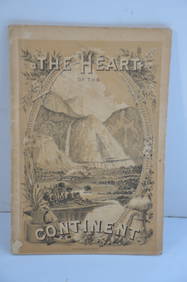
Chicago Burlington and Quincy RR The Heart of the Continent Book-1882JM Hobby Supply and Railroad Artifact Auctions4.4(127)See Sold PriceFeb 24, 2024
Rock Island RR Iowa and Minnesota Lakes Country Brochure-1926JM Hobby Supply and Railroad Artifact Auctions4.4(127)See Sold PriceFeb 24, 2024
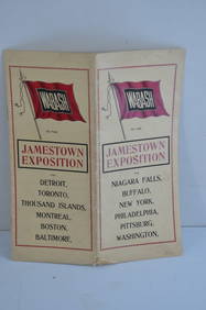
Wabash RR 1907 Jamestown Exposition BrochureJM Hobby Supply and Railroad Artifact Auctions4.4(127)See Sold PriceFeb 24, 2024
Chicago and Northwestern RY April 20, 1906 Public TimetableJM Hobby Supply and Railroad Artifact Auctions4.4(127)See Sold PriceFeb 24, 2024
Chicago Burlington and Quincy RR July 1, 1903 Public TimetableJM Hobby Supply and Railroad Artifact Auctions4.4(127)See Sold PriceFeb 24, 2024
Arrowsmith & Lewis - Map of the United StatesTrillium Antique Prints & Rare Books4.5(33)See Sold PriceFeb 24, 2024
Carey, pub. 1796 - Map of KentuckyTrillium Antique Prints & Rare Books4.5(33)See Sold PriceFeb 24, 2024
Carey, pub. 1796 - Map of the Tennassee State formerly part of North Carolina (Tennessee)Trillium Antique Prints & Rare Books4.5(33)See Sold PriceFeb 24, 2024


![1908 Cram Map of Texas [verso] Oklahoma -- Map of Texas (1 of 3)](https://p1.liveauctioneers.com/5584/195879/98794767_1_x.jpg?height=282&quality=70&version=1614724478)