ATLAS of ANTIENT GEOGRAPHY by SAMUEL BUTLER 1843John McInnis Auctioneers,LLC4.6(502)See Sold PriceFeb 24, 2024
18TH C. ANTIQUE MAP: FRENCH & INDIAN WAR, FRAMEDThomaston Place Auction Galleries4.4(386)See Sold PriceFeb 24, 2024
Rand McNally Railroad Map Cabinet w/ 21 Railroad MapsRail & Road Auctions4.6(165)See Sold PriceMar 08, 2024
Keith Haring - Ink on New York Map, Best Buddies, Inscribed, Signed, and DatedSapphire Auction Gallery4(67)See Sold PriceMar 02, 2024
LATE 17TH C. FRENCH MAP OF THE NEW WORLD BY ALEXIS-HUBERT JAILLOT (1632-1712)Thomaston Place Auction Galleries4.4(386)See Sold PriceFeb 24, 2024
Central Railroad of New Jersey Map of Sandy Hook Route-ca. 1903JM Hobby Supply and Railroad Artifact Auctions4.4(126)See Sold PriceFeb 24, 2024
Lot of Six Mixed Atlas Box Cars-HO Scale-New in BoxJM Hobby Supply and Railroad Artifact Auctions4.4(126)See Sold PriceFeb 25, 2024
Rand McNally/Santa Fe Railroad Map of Iowa-1912JM Hobby Supply and Railroad Artifact Auctions4.4(126)See Sold PriceFeb 24, 2024
NICOLAES VISSCHER (NETHERLANDS, 1618-1709) MAP OF THE NEW WORLDThomaston Place Auction Galleries4.4(386)See Sold PriceFeb 24, 2024
17TH C. WORLD MAP BY NICOLAES VISSCHER (NETHERLANDS, 1618-1709)Thomaston Place Auction Galleries4.4(386)See Sold PriceFeb 24, 2024
Lot of Six Mixed Atlas Cabooses-HO Scale-New in BoxJM Hobby Supply and Railroad Artifact Auctions4.4(126)See Sold PriceFeb 25, 2024
Sharp map of Mass., Conn. & Rhode Island by S. Augustus MitchellImpressive map of these New England states with special emphasis on showing the nearby islands. Shows complete rail system at the time, along with towns, cities, roads, rivers, lakes, bays, islands, hSee Sold Price
Map of Massachusetts, Connecticut and Rhode IslandMap of Massachusetts, Connecticut and Rhode Island, published by S. Augustus Mitchell, 1831. 17"H x 21 1/4"W, Watercolor is bright, small holes at folds, some folds with old tape repair. Full leatherSee Sold Price
Sold1856 Hand Drawn Map: Mass, R.I., Conn. Long IslandInk on paper. Signed lower right "Anne M. Prentis, September 22nd, 1856". Showing Massachusetts, Rhode Island, Connecticut, and Long Island, with mountains, rivers, bodies of water, and islands, withSee Sold Price
SoldFINLEY, MAP OF MASS, CONN, RI,ENGR W/HC,C.1826Artist: Finley, Title: Map of Massachusetts, Connecticut, and Rhode Island, Pub: A New American Atlas, Date: C.1826, Medium: Hand-colored engraving, Paper size: 21 x 17, Retail: $1400, Condition: FairSee Sold Price
Sold"Map of Massachusetts, Connecticut and Rhode Isla"Map of Massachusetts, Connecticut and Rhode Island constructed from the latest Authorities." "Published by Augustus Mitchell, Philadelphia 1840" Map in very good condition with no tears and good coloSee Sold Price
Mitchell: Antique Map of Massachusets, Conneticut, 1869Title/Content of Map: Massachusets, Conneticut & Rhode Island by Mitchell Date Printed: 1869 Cartographer: Augustus S. Mitchell Material/Medium: Paper Size: 13" x 15" Hand colored steel engraved Map.See Sold Price
Mitchell: Antique Map of Massachusetts Conneticut, 1869Title/Content of Map: Massachusetts, Conneticut & Rhode Island by Mitchell Date Printed: 1869 Cartographer: Augustus S. Mitchell Material/Medium: Paper Size: 12" x 15" Hand colored engraved Map. FromSee Sold Price
Samuel Augustus Mitchell (1790-1868), "County Map ofSamuel Augustus Mitchell (1790-1868), "County Map of New York, New Hampshire, Vermont, Massachusettes, Rhode Island and Connecticut," 1860, H. - 15 1/4 in., W. - 22 1/2 in.See Sold Price
SoldTwo New England Pocket MapsComprising Maine New Hampshire and Vermont published by S. Augustus Mitchell, Philadelphia 1833 and the second Massachusetts and Rhode Island published by J H Colton & Co. New York 1854. 21"h x 17"w aSee Sold Price
SoldMITCHELL, SAMUEL AUGUSTUS. Maps of Maine, NewMITCHELL, SAMUEL AUGUSTUS. Maps of Maine, New Hampshire and Vermont, Massachusetts & Rhode Island, Connecticut, New York, and New York City [cover title]. 6 lithographed maps, principally printed in oSee Sold Price
Rare Mitchell atlas of New EnglandTitle: Maps of Maine, New Hampshire and Vermont, Massachusetts & Rhode Island, Connecticut, New York, and New York City (wrapper title) Author:Mitchell, Samuel Augustus Description:6 color lithographeSee Sold Price
Massachusetts Conn. Rhode Island 1886Title/Content of Map: Massachusetts Conn. Rhode Island 1886 Date Printed: 1886 Material/Medium: paper Size: approx. 21.5x13.5 inches Additional Info: The People's Unrivaled Family Atlas of the World.See Sold Price
Massachusetts Conn. Rhode Island 1886Title/Content of Map: Massachusetts Conn. Rhode Island 1886 Date Printed: 1886 Material/Medium: paper Size: approx. 21.5x13.5 inches Additional Info: The People's Unrivaled Family Atlas of the World.See Sold Price
Massachusetts Conn. Rhode Island 1886Title/Content of Map: Massachusetts Conn. Rhode Island 1886 Date Printed: 1886 Material/Medium: paper Size: approx. 21.5x13.5 inches Additional Info: The People's Unrivaled Family Atlas of the World.See Sold Price
Sharp 1882 map of Rhode Island from early McNally Indexed atlasMap of Rhode Island showing railroads in red. Also shows coastal features, islands, bays and precise mapping of inlets, etc. Includes an inset of Providence. Extremely nice map of the state. From an eSee Sold Price
SoldAntique U.S. + Foreign Framed Maps-1800(3) Antique U.S. + Foreign frames maps - 1800's of Mass. + Rhode Island, Kansas City, MO, Philadelphia, Cincinnati, Detroit, New Mexico & Texas--example of misc. map sizes 8 3/4" x 9 3/4", 13 1/4" x 9See Sold Price
SoldGROUPING OF FRAMED NEW ENGLAND 19TH MAPSGrouping of three maps. 1) Framed 1862 hand color map of Massachusetts, Connecticut and Rhode Island. Map published by Mitchell. Map15 inches x 13 inches. Overall 21 inches x 19 inches. Somestains onSee Sold Price
SoldC. 1870 COLOR MAPS: NO AMERICA, IRELAND, EUROPE“Ireland in Provinces and Counties” and “County Map of Scotland” with inset map entitled “Shetland Islands” (1866) by S. Augustus Mitchell. Approx. 15 1/4” x 12 5/8”. Two color maps wiSee Sold Price
SoldROLL DOWN MAP MASS RI & CT. 1847 T & E ENSIGN NEW YOROLL DOWN MAP MASS RI & CT. 1847 T & E ENSIGN NEW YORK, MEASURES 29" X 37". MAP OF MASSACHUSETTS, RHODE ISLAND & CONNECTICUT, PUBLISHED BY T & E ENSIGN, NEW YORK. 1847. USUAL SCUFFS AND SMALL TEARS. WSee Sold Price
Sold1902 ROLL DOWN MAP MASS RI & CT. RAILROAD POST OFFIC1902 ROLL DOWN MAP MASS RI & CT. RAILROAD POST OFFICE TOWNSHIP AND COUNTY MAP OF MASSACHUSETTS, RHODE ISLAND AND CONNECTICUT, 1902. BY THE NATIONAL PUBLISHING COMPANY-1902, BOSTON, MASS. SOME TEARS ONSee Sold Price
Massachusetts Conn. Rhode Island 1886Title: Massachusetts Conn. Rhode Island 1886 Date Printed: 1886 Cartographer: Materials: paper Dimensions: approx. 21.5x13.5 inches Additional Info: The People's Unrivaled Family Atlas of the World. PSee Sold Price
SoldC. 1870 COLOR MAPS: AFRICA, & 2 OF ASIA“Map of Africa, Showing its Most Recent Discoveries” with inset map of “Island of St. Helena” (1866) by S. Augustus Mitchell. Approx. 15 1/4” x 12 5/8”. Color map on plate, with color inseSee Sold Price
SoldUSA 1903 Lot of 8 State Maps of New York & East CoastIncl Maine, Vermont/New Hampshire, Mass., Connecticut/Rhode Island, New York South, New York North, New York West and New Jersey. Lithograph Maps Published 1903 by Adam & Charles Black, Edinburgh & LoSee Sold Price
SoldMap of OceanicaDescription: Map of Oceanica Exhibiting Its Various Divisions, Island Groups &c. 73. With inset Map of the Sandwich Islands. 74. Entered ... 1860, by S. Augustus Mitchell, Jr.... Pennsylvania. MateriaSee Sold Price
Providence School: Stacy Tolman landscape (Attic Sale)Bert Gallery Studio Sales4.4(18)See Sold PriceFeb 27, 2024
1849 Mitchell School ATLAS 24 MAPS America Holy Land France Africa Egypt AsiaSchilb Antiquarian Rare Books4.8(421)See Sold PriceMar 31, 2024
1853 Colton's Railroad & Township Map of Massachusetts, Rhode Island, and ConnecticutRail & Road Auctions4.6(165)See Sold PriceMar 07, 2024
1849 THE NEW-ENGLAND MERCANTILE UNIONNorth American Artifact Auctions4.6(182)See Sold PriceApr 20, 2024
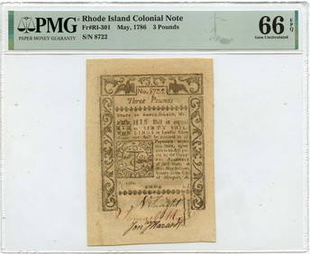
May 1786 3 Pounds Rhode Island Colonial Note RI-301 PMG Gem 66 EPQMynt Auctions4.6(680)See Sold PriceFeb 24, 2024
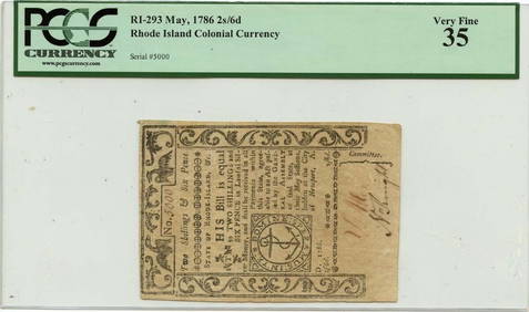
July 2 $2 Rhode Island Colonial Note 1780 RI-283 PMG AU58 EPQMynt Auctions4.6(680)See Sold PriceFeb 25, 2024
1780 July 2 $7 Rhode Island Colonial Note RI-287 PMG AU53 IssuedMynt AuctionsSee Sold PriceFeb 26, 2024
Mitchell - Map of the City of Washington (Washington, DC)Trillium Antique Prints & Rare Books4.5(30)See Sold PriceFeb 24, 2024
RHODE ISLAND CHIPPENDALE SLANT FRONT DESK.Amelia Jeffers, Auctioneers & Appraisers4.6(101)See Sold PriceMar 08, 2024
TWO PRINTS DEPICTING WATCH HILL, RHODE ISLAND Framed 18.5" x 21" and 19.5" x 21".Eldred's4.7(409)See Sold PriceMar 07, 2024
Two Hand-Colored 19th Century Maps of New Orleans and Louisiana, Larger- H.- 12 1/2 in., W.- 15 1/2Crescent City Auction Gallery4.3(229)See Sold PriceMar 08, 2024
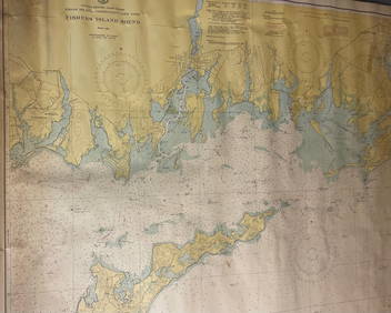
CHART: UNITED STATES - EAST COAST/ RHODE ISLAND - CONNECTICUT - NEW YORK/ Fishers IslandChurchill Galleries3.7(213)See Sold PriceFeb 26, 2024
Three early souvenirs from Mass. and Rhode IslandBaker's Antiques and Auctions3.3(462)See Sold PriceFeb 28, 2024
Joan Grober (AMERICAN / RHODE ISLAND, 20th Century) watercolor work on artist paper depicting aJoshua Kodner4.2(386)See Sold PriceMar 09, 2024
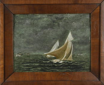
ANTIQUE AMERICAN SCHOOL OIL, RHODE ISLAND YACHT RACE.William Smith Auctions4.6(146)See Sold PriceMar 06, 2024