ATLAS of ANTIENT GEOGRAPHY by SAMUEL BUTLER 1843John McInnis Auctioneers,LLC4.5(505)See Sold PriceFeb 24, 2024
18TH C. ANTIQUE MAP: FRENCH & INDIAN WAR, FRAMEDThomaston Place Auction Galleries4.4(393)See Sold PriceFeb 24, 2024
Rand McNally Railroad Map Cabinet w/ 21 Railroad MapsRail & Road Auctions4.6(165)See Sold PriceMar 08, 2024
Keith Haring - Ink on New York Map, Best Buddies, Inscribed, Signed, and DatedSapphire Auction Gallery4(67)See Sold PriceMar 02, 2024
LATE 17TH C. FRENCH MAP OF THE NEW WORLD BY ALEXIS-HUBERT JAILLOT (1632-1712)Thomaston Place Auction Galleries4.4(393)See Sold PriceFeb 24, 2024
Central Railroad of New Jersey Map of Sandy Hook Route-ca. 1903JM Hobby Supply and Railroad Artifact Auctions4.4(127)See Sold PriceFeb 24, 2024
Lot of Six Mixed Atlas Box Cars-HO Scale-New in BoxJM Hobby Supply and Railroad Artifact Auctions4.4(127)See Sold PriceFeb 25, 2024
Rand McNally/Santa Fe Railroad Map of Iowa-1912JM Hobby Supply and Railroad Artifact Auctions4.4(127)See Sold PriceFeb 24, 2024
NICOLAES VISSCHER (NETHERLANDS, 1618-1709) MAP OF THE NEW WORLDThomaston Place Auction Galleries4.4(393)See Sold PriceFeb 24, 2024
17TH C. WORLD MAP BY NICOLAES VISSCHER (NETHERLANDS, 1618-1709)Thomaston Place Auction Galleries4.4(393)See Sold PriceFeb 24, 2024
Lot of Six Mixed Atlas Cabooses-HO Scale-New in BoxJM Hobby Supply and Railroad Artifact Auctions4.4(127)See Sold PriceFeb 25, 2024
Extremely scarce 1814 map of Maryland by M. CareyVery elusive map of Maryland from Mathew Carey's General Atlas, the first American atlas to feature hand-colored maps. This is from the extremely scarce 1816 edition which used many of the same maps uSee Sold Price
1814 map of Mexico showing Provincia Texas, M. CareyExtremely scarce and desirable map of Mexico or “New Spain” from Mathew Carey’s rare 1816 General Atlas. One of the earliest maps of Mexico published in America. Shows “ProvincSee Sold Price
Extremely scarce map of Delaware, M. Carey 1814One of the earliest obtainable maps of the State of Delaware. Mathew Carey's extremely scarce map titled “Delaware from the Best Authorities” from the scarce 1816 edition of Carey's GeneraSee Sold Price
Extremely scarce map of Connecticut, M. Carey 1814“Connecticut from the Best Authorities” delineated and engraved by Amos Doolittle. This map comes from an extremely scarce 1816 edition of Carey’s General Atlas, the same map that waSee Sold Price
Extremely scarce map of Pennsylvania, M. Carey 1814An important and very scarce map of Pennsylvania by Mathew Carey, one of the seminal figures in early American cartography. Published just after the War of 1812, this map is from Carey’s GeneralSee Sold Price
Extremely scarce and early map of Ohio, M. Carey 1814One of the most influential early maps of Ohio and the first large format map of Ohio to appear in an atlas. This 1816 example is the identical map that appeared in Carey’s 1814 General Atlas. TSee Sold Price
Rare map of Mississippi Territory, M. Carey 1814Rare map showing Mississippi and Alabama as one territory. From an extremely scarce 1816 edition of Mathew Carey General Atlas. Locates UPPER CREEKS, MIDDLE CREEKS and LOWER CREEKS in what will becomeSee Sold Price
Nice example of scarce 1814 map of Vermont, M. CareyVermont from Actual Surveys, Delineated & Engraved by Amos Doolittle. From an 1816 edition of Carey’s General Atlas (same map that’s in the 1814 edition). Very scarce map features a nice cSee Sold Price
Extremely scarce 1814 Mathew Carey map of New YorkHighly desirable and collectible War of 1812-era map of New York by Samuel Lewis. From a very scarce 1816 edition of Carey’s General Atlas (same map as the 1814 atlas). Map is colored by countieSee Sold Price
Ext. scarce 1814 map of British Possessions, M. CareyEssentially the second edition of this map, the first being from Carey’s 1795 atlas. The map was redrawn with new information for the 1814 Carey General Atlas. This example comes from his 1816 GSee Sold Price
Very scarce 1816 map of Massachusetts by M. CareyMathew Carey's map of Massachusetts, from the elusive 1816 edition of Carey's General Atlas. This extremely scarce map shows lighthouses, bays, islands, points, shoals, harbors, turnpikes, rivers, lakSee Sold Price
Extremely scarce map of South Carolina (1814)Scarce third state of Samuel Lewis’s map of South Carolina, appearing in the extremely scarce 1816 edition of Carey’s General Atlas (same map as in the 1814 Carey atlas). One of the earlieSee Sold Price
SoldState of TN Map, M. Carey, 1814THE STATE OF TENNESSEE map, published by Mathew Carey in Carey's General Atlas, Improved and Enlarged, Philadelphia, 1814. Copperplate engraving with hand coloring depicting the state of Tennessee witSee Sold Price
Scarce 1816 map of Rhode Island by M. CareyCharming and very early map of Rhode Island with original outline hand coloring by counties. Shows towns, settlements, major routes, waterways, meadows, swamps, bridges, ponds, ferries, hills, islandsSee Sold Price
Very scarce 1813 map of New Hampshire by M. CareyMathew Carey's “The State of New Hampshire compiled chiefly from actual surveys by Samuel Lewis in 1813” which first appeared in his American Atlas. The map is minutely detailed, showing iSee Sold Price
Scarce 1816 map of The Caracas by M. CareyScarce engraved map covers the region east of Lake Maracaibo and north of the equator. Map was issued during the Venezuelan War of Independence and civil war which engulfed the region. The rebel proviSee Sold Price
Scarce 1816 map of the Russian Empire, M. CareyScarce map of the Russian Empire from Mathew Carey’s very scarce 1816 edition of his General Atlas. Small stain in the Ghilaka region (far right middle part of map). Huge margins. Two other verySee Sold Price
Cary: Map of Caracas, 1814Cary: Map of Caracas, 1814. M. CAREY, CAREY, MATHEW/JOHN C. WARNICKE, sc., 1814, Folio - 12.25 H x 20.25 W Inches, Attractive early national map, double page, including the Guianas. Original coloring.See Sold Price
1814 Carey Map Of New Jersey1814 Carey Map Of New Jersey -- The State Of New Jersey Compiled From The Most Authentic Information, M Carey / S Lewis, 1814, Philadelphia, 17 x 11.8 in. A quite handsome New Jersey topographical mapSee Sold Price
SoldCarey: Antique Map of New Jersey, 1814Map: 1814 Carey Map of New Jersey -- The State of New Jersey Compiled from the most Authentic Information Date Printed: 1814, Philadelphia Cartographer: M Carey / S Lewis Size: 17 x 11.8 in. ConditionSee Sold Price
Carey: Map of New Jersey, 1814Map: 1814 Carey Map of New Jersey -- The State of New Jersey Compiled from the most Authentic Information Cartographer: M Carey / S Lewis Year / Place: 1814, Philadelphia Map Dimensions: 17 x 11.8 in.See Sold Price
Carey: Antique Map of New Jersey, 1814Map: 1814 Carey Map of New Jersey -- The State of New Jersey Compiled from the most Authentic Information Cartographer: M Carey / S Lewis Year / Place: 1814, Philadelphia Map Dimensions: 17 x 11.8 in.See Sold Price
Carey: Map of Europe, 1814Map of Europe. M. Carey, Bower, J. 1814. Double page map a polar projection that includes European Russia. Original coloring. Long repaired tear, some ink marks. Browned. Folio – 15.75 H x 18.00 W ISee Sold Price
Carey: A Map of Caracas, 1814Map: A Map of Caracas. Date: 1814 Author: M. CAREY, CAREY, MATHEW/JOHN C. WARNICKE, sc. Publisher: M. CAREY 1814 PHILADELPHIA Size: Folio – 12.25 H x 20.25 W Inches Attractive early national map, doSee Sold Price
Superb 13th century Thai Bronze Buddha- Lopburi- great face- Hard to find this nice.The Buddha Gallery4.4(29)See Sold PriceMar 13, 2024
M. de BOILEAU Satires & Works First 1st 1737 Edition Amsterdam Printing FrenchLuis Porretta Fine Arts4.3(10)See Sold PriceMar 02, 2024
HONEST JOHN OLIVER by James Morton 1st Edition Inscribed by Author ScarceLuis Porretta Fine Arts4.3(10)See Sold PriceMar 02, 2024
E M Forster Abinger Harvest True 1st Edition Dust Jacket - RARELuis Porretta Fine Arts4.3(10)See Sold PriceMar 02, 2024
ORGIAZZI 14 x Folio Sized Engravings Roman Road Signs etc. c1802 Aix FranceLuis Porretta Fine Arts4.3(10)See Sold PriceMar 02, 2024
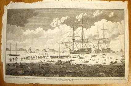
ALEXANDER HOGG ca1790 Engraving Captain Mulgrave Ships Ice Bound Cpt CookLuis Porretta Fine Arts4.3(10)See Sold PriceMar 02, 2024
DEVINE c1856 Dr Salters Map Of Lake Huron Ontario Indian Lands etc. No. 7 ScarceLuis Porretta Fine Arts4.3(10)See Sold PriceMar 02, 2024
MATTHEWS c1856 Map Of Upper Canada Ontario Indian Land Agency Divisions Scarce!Luis Porretta Fine Arts4.3(10)See Sold PriceMar 02, 2024
DUNLEVIE c1856 Map Counties Of Gaspe & Bonaventure Quebec Canada SCARCE! #1Luis Porretta Fine Arts4.3(10)See Sold PriceMar 02, 2024
Singing Frog Dressed as a Monk Extremely Scarce Ceramic BankThe RSL Auction Company4.6(240)See Sold PriceMar 09, 2024
Rare Expanded Three Seat Brake - Cast Iron ToyThe RSL Auction Company4.6(240)See Sold PriceMar 09, 2024
Battle of the Nile: Disposition of the English & French Fleets, at the Commencement of the Action,Trillium Antique Prints & Rare Books4.5(32)See Sold PriceFeb 24, 2024
Carey, pub. 1796 - Map of the State of MarylandTrillium Antique Prints & Rare Books4.5(32)See Sold PriceFeb 24, 2024
Carey, pub. 1796 - Map of KentuckyTrillium Antique Prints & Rare Books4.5(32)See Sold PriceFeb 24, 2024
Carey, pub. 1796 - Map of the Tennassee State formerly part of North Carolina (Tennessee)Trillium Antique Prints & Rare Books4.5(32)See Sold PriceFeb 24, 2024
1816 MAP SOUTHERN PART OF RUSSIA or MUSCOVY in EUROPE copper engraving ANTIQUEJasper524.5(9.9k)See Sold PriceFeb 27, 2024
1816 MAP NORTHERN PART OF RUSSIA or MUSCOVY in EUROPE copper engraving ANTIQUEJasper524.5(9.9k)See Sold PriceFeb 27, 2024
Extremely Scarce JB Owens Pottery Jardiniere Stand MajolicaMatthew Bullock Auctioneers4.7(1.8k)See Sold PriceMar 02, 2024
FIRST AMERICAN EDITION, 1814, JUNII JUVENALIS ET PERSII FLACCI SATIRAE ANTIQUENY Elizabeth 4.2(86)See Sold PriceMar 03, 2024