ATLAS of ANTIENT GEOGRAPHY by SAMUEL BUTLER 1843John McInnis Auctioneers,LLC4.6(502)See Sold PriceFeb 24, 2024
18TH C. ANTIQUE MAP: FRENCH & INDIAN WAR, FRAMEDThomaston Place Auction Galleries4.4(386)See Sold PriceFeb 24, 2024
Rand McNally Railroad Map Cabinet w/ 21 Railroad MapsRail & Road Auctions4.6(165)See Sold PriceMar 08, 2024
Keith Haring - Ink on New York Map, Best Buddies, Inscribed, Signed, and DatedSapphire Auction Gallery4(67)See Sold PriceMar 02, 2024
LATE 17TH C. FRENCH MAP OF THE NEW WORLD BY ALEXIS-HUBERT JAILLOT (1632-1712)Thomaston Place Auction Galleries4.4(386)See Sold PriceFeb 24, 2024
Central Railroad of New Jersey Map of Sandy Hook Route-ca. 1903JM Hobby Supply and Railroad Artifact Auctions4.4(126)See Sold PriceFeb 24, 2024
Lot of Six Mixed Atlas Box Cars-HO Scale-New in BoxJM Hobby Supply and Railroad Artifact Auctions4.4(126)See Sold PriceFeb 25, 2024
Rand McNally/Santa Fe Railroad Map of Iowa-1912JM Hobby Supply and Railroad Artifact Auctions4.4(126)See Sold PriceFeb 24, 2024
NICOLAES VISSCHER (NETHERLANDS, 1618-1709) MAP OF THE NEW WORLDThomaston Place Auction Galleries4.4(386)See Sold PriceFeb 24, 2024
17TH C. WORLD MAP BY NICOLAES VISSCHER (NETHERLANDS, 1618-1709)Thomaston Place Auction Galleries4.4(386)See Sold PriceFeb 24, 2024
Lot of Six Mixed Atlas Cabooses-HO Scale-New in BoxJM Hobby Supply and Railroad Artifact Auctions4.4(126)See Sold PriceFeb 25, 2024
Antique Map Print - Map of Namur - Brabant, Hainaut, Luzimborgo - BelgiumMap of Namur is located between Brabant, Hainaut, Luzimborgo and the city of Liège with small territories and narrow borders, but it is a small village. Date: 16th Century. Size: 13” x 19&#See Sold Price
Antique Map Print - Europe - Map of Belgium - Luxembourg - Northern FranceTitle: Antique Map Print - Europe - Map of Belgium - Luxembourg - Northern France Date/Period: 1720 Dimension: 61 cm x 53 cm Material: Paper Additional Information: Johann Baptist Homann. Arena MartisSee Sold Price
Antique Map Print - Heinrich Leutemann - Map of Belgium - 19th CenturyTitle/Content: Antique Map Print - Heinrich Leutemann - Map of Belgium - 19th Century Date: 19th century Material: Paper Dimensions: 8” x 10” inches / 20 cm x 25 cm Description: Map of BelSee Sold Price
Antique Map Print - Johann Baptist Homann - Map of Belgium and LuxembourgA beautifully detailed c. 1747 J. B. Homann's map of Belgium and Luxembourg. Depicts Belgium and Luxembourg as well as parts of Holland, France and Germany. The map notes fortified cities, villages, rSee Sold Price
1792 ANTIQUE MAP - HAINAUT BELGIUM 31 by 22" ORIGINAL1792 ANTIQUE MAP - HAINAUT BELGIUM Damaged upper left corner. Size 31 by 22" (002) Please note that this lot has a confidential reserve. When you leave a bid in advance of the auction, submit your maxSee Sold Price
1792 ANTIQUE MAP - HAINAUT BELGIUM 31 by 22" ORIGINAL1792 ANTIQUE MAP - HAINAUT BELGIUM Damaged upper left corner. Size 31 by 22" (002) Reserve: $70.00 Shipping: Domestic: Flat-rate of $25.00 to anywhere within the contiguous U.S. InternationalSee Sold Price
1792 ANTIQUE MAP - HAINAUT BELGIUM 31 by 22" ORIGINAL1792 ANTIQUE MAP - HAINAUT BELGIUM Damaged upper left corner. Size 31 by 22" (002) Reserve: $69.99 Shipping: Domestic: Flat-rate of $25.00 to anywhere within the contiguous U.S. InternationalSee Sold Price
1792 ANTIQUE MAP - HAINAUT BELGIUM 31 by 22" ORIGINAL1792 ANTIQUE MAP - HAINAUT BELGIUM Damaged upper left corner. Size 31 by 22" (002) Reserve: $74.99 Shipping: Domestic: Flat-rate of $25.00 to anywhere within the contiguous U.S. InternationalSee Sold Price
1792 Antique Map - Hainaut Belgium 31 by 22" Original1792 ANTIQUE MAP - HAINAUT BELGIUM Damaged upper left corner. Size 31 by 22" Please note that this lot has a confidential reserve. When you leave a bid in advance of the auction, submit your maximum.See Sold Price
1792 ANTIQUE MAP - HAINAUT BELGIUM 31 by 22" ORIGINAL1792 ANTIQUE MAP - HAINAUT BELGIUM Repaired upper left corner and margins. Size 31 by 22" Reserve: $70.00 Shipping: Domestic: Flat-rate of $25.00 to anywhere within the contiguous U.S. InternationalSee Sold Price
1792 ANTIQUE MAP - HAINAUT BELGIUM 31 by 22" ORIGINAL1792 ANTIQUE MAP - HAINAUT BELGIUM Repaired upper left corner and margins. Size 31 by 22" Reserve: $70.00 Shipping: Domestic: Flat-rate of $25.00 to anywhere within the contiguous U.S. InternationalSee Sold Price
1792 ANTIQUE MAP - HAINAUT BELGIUM 31 by 22" ORIGINAL1792 ANTIQUE MAP - HAINAUT BELGIUM Repaired upper left corner and margins. Size 31 by 22" Reserve: $70.00 Shipping: Domestic: Flat-rate of $25.00 to anywhere within the contiguous U.S. InternationalSee Sold Price
1792 ANTIQUE MAP - HAINAUT BELGIUM 31 by 22" ORIGINAL1792 ANTIQUE MAP-HAINAUT BELGIUM Repaired upper left corner and margins. Size 31 by 22" Reserve: $70.00 Shipping: Domestic: Flat-rate of $25.00 to anywhere within the contiguous U.S. International: FoSee Sold Price
1792 ANTIQUE MAP - HAINAUT BELGIUM 31 by 22" ORIGINAL1792 ANTIQUE MAP - HAINAUT BELGIUM Repaired upper left corner and margins. Size 31 by 22" Reserve: $70.00 Shipping: Domestic: Flat-rate of $25.00 to anywhere within the contiguous U.S. InternationalSee Sold Price
1792 ANTIQUE MAP - HAINAUT BELGIUM 31 by 22" ORIGINAL1792 ANTIQUE MAP - HAINAUT BELGIUM Repaired upper left corner and margins. Size 31 by 22" Reserve: $70.00 Shipping: Domestic: Flat-rate of $25.00 to anywhere within the contiguous U.S. InternationalSee Sold Price
de Fer: Antique Map of Namur, Belgium, 1705TITLE/CONTENT OF MAP: 'Namur, avec ces nouveaux ouvrages, faits et projetés jusqu à l'année 1693 [Namur, with its new works completed and projected up to the year 1693]' DATE PRINTED: 1705 IMAGE SISee Sold Price
de Fer: Antique Map of Namur, Belgium, 1705Title/Content of Map: 'Namur'. Plan of town/city & fortifications. Belgium. Date Printed: 1705 Image Size: Approx 21.5 x 32.0cm, 8.5 x 12.5 inches (Large) Type: Early 18th century copperplate map CondSee Sold Price
Antique Map Print - Europe - Plan of the Passage of the Lines of Brabant - 1705Break through the French lines in Brabant, 1705; Plan du Passage des Lignes de Brabant, Forces Le 18 Juillet 1705, Par les Armes des Allieeez (...). Map of breaking the French lines in Brabant with thSee Sold Price
Antique Map Print - Europe - Map of Netherlands - Belgian Zeeland - Homann HeirsHomann Heirs. Antique map titled "Septem Provinciae seu Belgium Foederatum quod generliter Hollandia (..)." Detailed antique map of the seven provinces of the Belgian Federation (Dutch Federation), noSee Sold Price
1579 dated MAP of NAMUR BELGIUM antique 16 by 20.5"1579 dated MAP of NAMUR, BELGIUM Titled: Namurcum. Early map of the old county of Namur with beautiful cartouches, with coat of arms and compass rose. German gothic text on verso. This map is from: 'TSee Sold Price
1579 dated MAP of NAMUR BELGIUM antique 16 by 20.5"1579 dated MAP of NAMUR, BELGIUM Titled: Namurcum. Early map of the old county of Namur with beautiful cartouches, with coat of arms and compass rose. German gothic text on verso. This map is from: 'TSee Sold Price
1579 dated MAP of NAMUR BELGIUM antique 16 by 20.5"1579 dated MAP of NAMUR, BELGIUM Titled: Namurcum. Early map of the old county of Namur with beautiful cartouches, with coat of arms and compass rose. German gothic text on verso. This map is from: 'TSee Sold Price
SoldBarclay, James 1809 Antique Map. Netherlands & Belgium"The Seven United Provinces, with The Dutch Possessions in Flanders, Brabant and Limburg" Outline Hand Coloured Copper Engraved Map Published 1809, Leeds for "Barclay's Complete and Universal DictionaSee Sold Price
Map of Holland & Belgium (Amsterdam & Brussels), 1875Original engraving by Colton, 1875. Map features inset of Amsterdam & Brussels. Dimensions: 13 3/4 x 17 1/4 inches.See Sold Price
NORTHERN AFRICA. Morocco Tunisia Algeria. Caravan routes. RAPKIN/TALLIS 1851 mapJasper524.5(9.8k)See Sold PriceFeb 28, 2024
WEST AFRICA Explorers' routes Senegal Ashanti. Mountains of Kong. SDUK 1857 mapJasper524.5(9.8k)See Sold PriceFeb 28, 2024
WEST AFRICA Niger/Gambia rivers tribes towns. 'Pays des Negres'. MALLET 1683 mapJasper524.5(9.8k)See Sold PriceFeb 28, 2024
EARLY COLONIAL WEST AFRICA. Empires of Sokoto Gando Mas.Tribes.Fellatah 1882 mapJasper524.5(9.8k)See Sold PriceFeb 28, 2024
Pre-colonial Africa. Mountains of Kong/Moon. Caravan routes. THOMSON 1817 mapJasper524.5(9.8k)See Sold PriceFeb 28, 2024
AFRICA. Pre 'Scramble for Africa'. BARTHOLOMEW 1876 old antique map plan chartJasper524.5(9.8k)See Sold PriceFeb 28, 2024
La Barbarie de la Nigritie et de la Guinée'. West Africa. DE L’ISLE 1745 mapJasper524.5(9.8k)See Sold PriceFeb 28, 2024
SOUTHERN AFRICA Monomotapa (Mutapa Kingdom) Cafrerie (Kaffraria) MALLET 1683 mapJasper524.5(9.8k)See Sold PriceFeb 28, 2024
Charles Antoine Lemaire (1800 - 1871) - Set of 4 Botanical Prints - Rose - Camellia Duchesse deProverde Auctions4.3(3)See Sold PriceFeb 28, 2024
Charles Antoine Lemaire (1800 - 1871) - Set of 4 Botanical Prints - Brassavola fragias - BerberioProverde Auctions4.3(3)See Sold PriceFeb 28, 2024
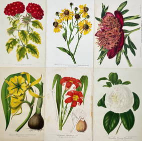
Charles Antoine Lemaire (1800 - 1871) - Set of 6 Botanical Prints - Ismene amancaes - Camellia FannyProverde Auctions4.3(3)See Sold PriceFeb 28, 2024
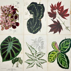
Charles Antoine Lemaire (1800 - 1871) - Set of 6 Botanical Prints - Alocasia - Calathea roseopicta -Proverde Auctions4.3(3)See Sold PriceFeb 28, 2024
Charles Antoine Lemaire (1800 - 1871) - Set of 8 Botanical Prints - Alstraemeria Argento - CayaponiaProverde Auctions4.3(3)See Sold PriceFeb 28, 2024
Charles Antoine Lemaire (1800 - 1871) - Set of 8 Botanical Prints - Embothrium coccineum -Proverde Auctions4.3(3)See Sold PriceFeb 28, 2024
Robert de Vaugondy - Map of Canada - Mer de l' Ouest or Sea of the West and a Northwest PassageProverde Auctions4.3(3)See Sold PriceFeb 28, 2024
Francis McNally - Antique Map of Ohio, Indiana & KentuckyProverde Auctions4.3(3)See Sold PriceFeb 28, 2024
Francis McNally - Antique Map of Washington, Oregon, Idaho, Nevada, Utah & ArizonaProverde Auctions4.3(3)See Sold PriceFeb 28, 2024
Vintage Map of Roman Forum - Vatican City - Versailles parkProverde Auctions4.3(3)See Sold PriceFeb 28, 2024