SoldLe Lievre Brothers (Publishers) Map of the IslandLe Lievre Brothers (Publishers) Map of the Island of Jersey,with all the Road, Lanes, Streams, &c., showing the island divided up into parishes, lithographed map with outline hand-colouring, 3See Sold Price
Map of Connecticut and Rhode Island 1889Map of Connecticut and Rhode Island Color Map. Questions on the Map at base. Publisher Harper Brothers Dated: Circa 1888 Dimensions: 20 x 12"See Sold Price
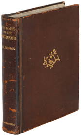
SoldStevenson's Treasure Island 1st American Finely boundHeading: Author: Stevenson, Robert Louis Title: Treasure Island Place Published: Boston Publisher:Roberts Brothers Date Published: 1884 Description: viii,292, [4] ad pp. FrSee Sold Price
Brother of “Whistler’s Mother” surveys the first RhodeHeading: (Rhode Island Manuscript Maps) Author: McNeill, William Gibbs Title: First Rhode Island Railroad surveyed by the artist Whistler's uncle Place Published: Publisher: Date Published:See Sold Price
Brother of “Whistler’s Mother” surveys the first RhodeHeading: (Rhode Island Manuscript Maps) Author: McNeill, William Gibbs Title: First Rhode Island Railroad surveyed by the artist Whistler's uncle Place Published: Publisher: Date Published:See Sold Price
North and South America, with California an island 1676Heading: Author: Du Val, Pierre Title: L'Amerique autrement le Nouveau Monde et Indes Occidentales... Place Published: Paris Publisher: Date Published: 1676 Description: CoSee Sold Price
SoldNorth and South America, with California an island 1676Heading: Author: Du Val, Pierre Title: L'Amerique autrement le Nouveau Monde et Indes Occidentales... Place Published: Paris Publisher: Date Published: 1676 Description: CoSee Sold Price
North and South America, with California an island 1676Heading: Author: Du Val, Pierre Title: L'Amerique autrement le Nouveau Monde et Indes Occidentales... Place Published: Paris Publisher: Date Published: 1676 Description: CoSee Sold Price
SoldSTEVENSON, Robert Louis (1850-1894). Treasure Island. Bosto...STEVENSON, Robert Louis (1850-1894). Treasure Island. Boston: Roberts Brothers, 1884. 8vo. Half-title, frontispiece map, 4 wood-engraved by F.T. Merrill; 12pp. publisher’s ads at end. Original pSee Sold Price
SoldAnson's voyage round the world, California an islandHeading: Author: Anson, George Title: Carte dans laquelle on Voit la Route que le Centurion a Tenu dans la Voiage au tour du Monde Place Published: Paris Publisher: Date Published: 1750 <See Sold Price
[MAP]. VON FRANKENBERG. City of Stockton. [1870?]384. [MAP]. VON FRANKENBERG, E. (delineator) & William Kierski & Brother (publishers). Map of the City of Stockton and San Joaquin Valley... [right of title, at bottom of map, inset map of theSee Sold Price
Group of (3) booksGroup of (3) books, to include: ''Missionary Travels and Researches in South Africa,'' by David Livingstone, 1858, New York: Harper & Brothers, Publishers, including folding maps, title pages stampedSee Sold Price
David Livingstone, New YorkGroup of (3) books, to include: ''Missionary Travels and Researches in South Africa,'' by David Livingstone, 1858, New York: Harper & Brothers, Publishers, including folding maps, title pages stampedSee Sold Price
Through the Darkest Continent H.M Stanley-Vol I & IIThrough the Darkest Continent H.M Stanley-Vol I & II THROUGH THE DARKEST CONTINENT H.M STANLEY 1878- HARPER AND BROTHERS PUBLISHERS 1878 WITH MAPS- SPINES DETATCHED, AS FOUND, IMPERFECTIONSSee Sold Price
SoldMap of Texas and Indian TerritoryMap of Texas and Indian Territory West Central States and States of the Plains - Southern Division. Color Map. Publisher Harper Brothers Dated: 1888 DimenSee Sold Price
Map of Texas and Indian TerritoryMap of Texas and Indian Territory West Central States and States of the Plains - Southern Division. Color Map. Publisher Harper Brothers Dated: 1888 DSee Sold Price
Political Map of North AmericaPolitical Map of North America Color Map. Publisher Harper Brothers Dated: 1888 Dimensions: 12 x 9" Condition Report Text on verso. Good PlusSee Sold Price
Map of the Middle Atlantic StatesMiddle Atlantic States Color Map. Publisher Harper Brothers Dated: 1888 Dimensions: 12 x 9" Condition Report Text on verso. Good Plus.See Sold Price
Map of Eastern & Western CanadaMap of Eastern & Western Canada Color Map. Publisher Harper Brothers Dated: 1888 Dimensions: 12 x 9" Condition Report Text on verso. Good PluSee Sold Price
Map of Mexico - West Indies & Central AmericaMap of Mexico - West Indies & Central America Color Map. Publisher Harper Brothers Dated: 1888 Dimensions: 12 x 9" Condition Report Text on vSee Sold Price
Map of the South Atlantic & Central StatesMap of the South Atlantic & South Central States Color Map. Publisher Harper Brothers Dated: 1888 Dimensions: 12 x 9" Condition Report Text oSee Sold Price
Map of Central States - Northern DivisionMap of Central States - Northern Division Color Map. Publisher Harper Brothers Dated: 1888 Dimensions: 12 x 9" Condition Report Text on versoSee Sold Price
Map of West Central and Plains StatesMap of West Central and Plains States - Northern Divison Color Map. Publisher Harper Brothers Dated: 1888 Dimensions: 12 x 9" Condition Report <See Sold Price
Map of the British IslesMap of the British Isles Color Map. Publisher Harper Brothers Dated: 1888 Dimensions: 12 x 9" Condition Report Text on verso. Good Plus.<See Sold Price
Geographical, Statistical, and Historical Map of the Leeward Islands.Jasper524.5(9.8k)See Sold PriceFeb 27, 2024
Italian edition of Sanson's map of North America, 1677PBA Galleries4.7(381)See Sold PriceMar 07, 2024
Carte de la Guinée, contenant…'. Guinea & Cape Verde islands. BONNE 1771 mapJasper524.5(9.8k)See Sold PriceFeb 28, 2024
Le Canal de Mosambique, l'Isle de Madagascar… Mozambique. Africa. BONNE 1788 mapJasper524.5(9.8k)See Sold PriceFeb 28, 2024
Le Canal de Mosambique, l'Isle de Madagascar… Mozambique. Africa. BONNE 1790 mapJasper524.5(9.8k)See Sold PriceFeb 28, 2024
Partie Occidentale de l’Afrique. West Africa coast Canary islands BONNE 1788 mapJasper524.5(9.8k)See Sold PriceFeb 28, 2024
Framed Vintage Map Of Le Port Au Prince In The Island Of Santo DomingoRapid Estate Liquidators and Auction Gallery4.5(1.1k)See Sold PriceMar 01, 2024


![[MAP]. VON FRANKENBERG. City of Stockton. [1870?] (1 of 5)](https://p1.liveauctioneers.com/514/38482/16500468_1_x.jpg?height=282&quality=70&version=1363615005)