ATLAS of ANTIENT GEOGRAPHY by SAMUEL BUTLER 1843John McInnis Auctioneers,LLC4.5(505)See Sold PriceFeb 24, 2024
18TH C. ANTIQUE MAP: FRENCH & INDIAN WAR, FRAMEDThomaston Place Auction Galleries4.4(393)See Sold PriceFeb 24, 2024
Rand McNally Railroad Map Cabinet w/ 21 Railroad MapsRail & Road Auctions4.6(165)See Sold PriceMar 08, 2024
Keith Haring - Ink on New York Map, Best Buddies, Inscribed, Signed, and DatedSapphire Auction Gallery4(67)See Sold PriceMar 02, 2024
LATE 17TH C. FRENCH MAP OF THE NEW WORLD BY ALEXIS-HUBERT JAILLOT (1632-1712)Thomaston Place Auction Galleries4.4(393)See Sold PriceFeb 24, 2024
Central Railroad of New Jersey Map of Sandy Hook Route-ca. 1903JM Hobby Supply and Railroad Artifact Auctions4.4(127)See Sold PriceFeb 24, 2024
Lot of Six Mixed Atlas Box Cars-HO Scale-New in BoxJM Hobby Supply and Railroad Artifact Auctions4.4(127)See Sold PriceFeb 25, 2024
Rand McNally/Santa Fe Railroad Map of Iowa-1912JM Hobby Supply and Railroad Artifact Auctions4.4(127)See Sold PriceFeb 24, 2024
NICOLAES VISSCHER (NETHERLANDS, 1618-1709) MAP OF THE NEW WORLDThomaston Place Auction Galleries4.4(393)See Sold PriceFeb 24, 2024
17TH C. WORLD MAP BY NICOLAES VISSCHER (NETHERLANDS, 1618-1709)Thomaston Place Auction Galleries4.4(393)See Sold PriceFeb 24, 2024
Lot of Six Mixed Atlas Cabooses-HO Scale-New in BoxJM Hobby Supply and Railroad Artifact Auctions4.4(127)See Sold PriceFeb 25, 2024
SoldBowen, Emanuel Collection of engraved maps, c.1750-65Bowen, Emanuel Collection of engraved maps, c.1750-65 including: A New and Accurate Map of China; A New and Accurate Map of the Empire of Japan; Turky in Asia, Arabia, etc.; A New and Accurate Map ofSee Sold Price
SoldAn Accurate Map of the County of Surrey. c.1750.[England] Bowen, Emanuel. “An Accurate Map of the County of Surrey; Divided into its Hundreds.” London, c.1750. Engraved map. 27 7/8” x 20 3/4”. Framed: 31” x 24”.See Sold Price
SoldA collection of five engraved county maps.A collection of five engraved county maps. Cambridgeshire, Suffolk and Huntingdonshire by Robert Morden; Cambridgeshire and Huntingdonshire by Emanuel Bowen; some colouring, condition varies (5)See Sold Price
Sold18th c. Map of America- Emanuel Bowen18th c. Map- ''A New and Accurate Map of America''- engraved map, 1748, from John Harris- ''Complete Collection of Voyages and Travels'', short repaired separation at top of centerfold. 14 3/8 x 17 5/See Sold Price
GreeceTitle:Greece Date/Period: 1744-1748 Materials: Copperplate engraved. Dimensions: 16 x 9 3/4 “ By.Emanuel Bowen. From. John Harris’s a Complete Collection of voyages and travels. Published. London.See Sold Price
GreeceTitle: Greece Date/Period: 1744-1748 Materials: Copperplate engraved. Size: 16 x 9 3/4 “ Description: By.Emanuel Bowen. From. John Harris’s a Complete Collection of voyages and travels. Published.See Sold Price
GreeceTitle: Greece Date/Period: 1744-1748 Materials: Copperplate engraved. Dimensions: 16 x 9 3/4 “ By.Emanuel Bowen. From. John Harris’s a Complete Collection of voyages and travels. Published. LondonSee Sold Price
SoldGreeceTitle: Greece Date/Period: 1744-1748 Materials: Copperplate engraved. Size: 16 x 9 3/4 “ Description: By.Emanuel Bowen. From. John Harris’s a Complete Collection of voyages and travels. Published.See Sold Price
GreeceTitle: Greece Date/Period: 1744-1748 Materials: Copperplate engraved. Size: 16 x 9 3/4 “ By.Emanuel Bowen. From. John Harris’s a Complete Collection of voyages and travels. Published. London. ReseSee Sold Price
GreeceTitle: Greece Date/Period: 1744-1748 Materials: Copperplate engraved. Dimensions: 16 x 9 3/4 “ By.Emanuel Bowen. From. John Harris’s a Complete Collection of voyages and travels. Published. LondonSee Sold Price
SoldChina.- Bowen (Emanuel) ChinaChina.- Bowen (Emanuel) China,engraved map with hand-colouring, 350 x 425mm, central vertical fold, surface dirt and minor spotting, c.1745.See Sold Price
SoldMap of Cuba by Emanuel Bowen c.1747Title: A New & Accurate Map of the Island of Cuba Drawn from Most Approved Maps & Charts and Regulated by Astron. Observations Author: Bowen, Emanuel Description: Copper-engraved map. 18x42 cm. (7x16�See Sold Price
SoldBowen (Emanuel) Nubia & AbissiniaBowen (Emanuel) Nubia & Abissinia,engraved map, with outline hand-colouring, 355 x 435mm, central vertical fold, minor surface dirt, c.1745; Barbary, showing the eastern and western parts in tSee Sold Price
Bowen (Emanuel) Nubia & AbissiniaBowen (Emanuel) Nubia & Abissinia,engraved map, with outline hand-colouring, 355 x 435mm, central vertical fold, minor surface dirt, c.1745; Barbary, showing the eastern and western parts in tSee Sold Price
Bowen map of Lancashire, England, 1761Title: Lancashire Divided into Hundreds: Containing ye Buroughs and Market Towns, Rivers, Roads, Distances &c. Author: Bowen, Emanuel Description: Copper-engraved map, hand-colored (later). 18.5x16.5See Sold Price
Scarce Antique 1777 Engraved Map by Emanuel BowenScarce Antique 1777 engraved map of The County of Kent by Emanuel Bowen (fl. 1714 - died 1767) | | Hand Colored Engraving of the County of Kent also showing views of Canterbury and Rochester CathedralSee Sold Price
SoldBOWEN, Emanuel c.1750 Yorkshire Map. 'An AccurateBOWEN, Emanuel c.1750 Yorkshire Map. 'An Accurate Map of the West Riding of Yorkshire.' Published c.1750, London, by Bowles & Sayer. With full margins & period outline colour. 58x76cmSee Sold Price
Sold18th C. Map of LouisianaAn 18th C. hand-colored engraved map by Emanuel Bowen, titled "A New and Accurate Map of Louisiana with Part of Florida and Canada, and the Adjacent Countries", Plate 59. Likely from the "Complete AtlSee Sold Price
SoldScotland.- Mackenzie (Murdoch) - Orcades: or afirst edition , list of subscribers, 8 double-page or folding engraved maps by Emanuel Bowen, the first with partial hand-colouring in yellow, rather soiled, one or two small paint stains, a few tearsSee Sold Price
SoldAntique Printed Map of Flintshire by John Owen andPublished 1731 AD. Being pages 265 and 266 of Owen and Bowen's Britannia Depicta Or Ogilby Improv'd, with text by by John Owen and the maps engraved by Emanuel Bowen; page 265 depicting the map of FliSee Sold Price
Sold1747 Engraved map of Asia by Emanuel Bowen1747 Engraved map of Asia by Emanuel Bowen "A New & Accurate Map of Asia", from 'A Complete System of Geography' (London: for William Innys, Richard Ware, etc, 1747), in fine contemporary hand color,See Sold Price
SoldBOWEN, EMANUEL. A Complete System of GeographyBOWEN, EMANUEL. A Complete System of Geography. 69 engraved maps, 2 plates. 2 volumes. Folio, 415x270 mm, contemporary calf, darkened and rubbed; scattered minor foxing, but generally quite clean. WitSee Sold Price
Owen & Bowen. Britannia DepictaOwen (John) and Emanuel Bowen. Britannia Depicta, 271 engraved road-maps only (of 273, lacking 51/52), also lacking engraved title, contemporary calf, worn, 4to, 1764.See Sold Price
SoldMAP-1750 New and Accurate Map of America By BowenHistoric Maps1750 "A New and Accurate Map of America..." By Bowen 1750 Engraved Hand-Colored Map entitled, "A New and Accurate Map of America..." engraved by Emanuel Bowen, Choice VerySee Sold Price
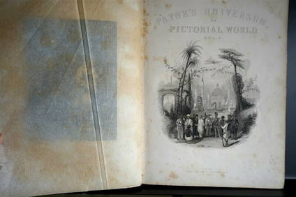
PAYNES UNIVERSUM ca1850 Calf 1st ed Travel 65 X Engravings China etc.Luis Porretta Fine Arts4.3(10)See Sold PriceMar 02, 2024
[ARCTIC]. BOWEN, Emanuel. A New & Accurate Map of the North...Potter & Potter Auctions4.6(545)See Sold PriceMar 07, 2024
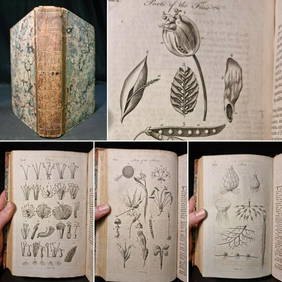
1797 Universal Magazine BOTANY PLATES Flowers FRUIT 12 Copper Engraved PlatesPrivate NY Collection4.2(22)See Sold PriceMar 01, 2024
Map: An 18thC engraved map of Bedfordshire titled An Accurate Map of the County of Bedford DividedClaydon Auctioneers Ltd4.3(125)See Sold PriceFeb 26, 2024
1816 MAP SOUTHERN PART OF RUSSIA or MUSCOVY in EUROPE copper engraving ANTIQUEJasper524.5(9.9k)See Sold PriceFeb 27, 2024
Churchill & Nieuhof 1744 Folio Map. Cape of Good Hope, South AfricaAlbion Auctions4.6(341)See Sold PriceMar 01, 2024
Churchill & Nieuhof 1744 Folio Map. Batavia Indonesia East IndiesAlbion Auctions4.6(341)See Sold PriceMar 01, 2024
Churchill & Nieuhof 1744 Map. Batavia Jakarta IndonesiaAlbion Auctions4.6(341)See Sold PriceMar 01, 2024
Jeremiah King (London, England) Regency Era Sterling Silver Tankard, 1820, H 6.5" W 4.75" L 6.5"DuMouchelles4.6(830)See Sold PriceMar 14, 2024


![[ARCTIC]. BOWEN, Emanuel. A New & Accurate Map of the North... (1 of 1)](https://p1.liveauctioneers.com/928/318880/171360917_1_x.jpg?height=282&quality=70&version=1707501302)