ATLAS of ANTIENT GEOGRAPHY by SAMUEL BUTLER 1843John McInnis Auctioneers,LLC4.6(502)See Sold PriceFeb 24, 2024
18TH C. ANTIQUE MAP: FRENCH & INDIAN WAR, FRAMEDThomaston Place Auction Galleries4.4(386)See Sold PriceFeb 24, 2024
Rand McNally Railroad Map Cabinet w/ 21 Railroad MapsRail & Road Auctions4.6(165)See Sold PriceMar 08, 2024
Keith Haring - Ink on New York Map, Best Buddies, Inscribed, Signed, and DatedSapphire Auction Gallery4(67)See Sold PriceMar 02, 2024
LATE 17TH C. FRENCH MAP OF THE NEW WORLD BY ALEXIS-HUBERT JAILLOT (1632-1712)Thomaston Place Auction Galleries4.4(386)See Sold PriceFeb 24, 2024
Central Railroad of New Jersey Map of Sandy Hook Route-ca. 1903JM Hobby Supply and Railroad Artifact Auctions4.4(126)See Sold PriceFeb 24, 2024
Lot of Six Mixed Atlas Box Cars-HO Scale-New in BoxJM Hobby Supply and Railroad Artifact Auctions4.4(126)See Sold PriceFeb 25, 2024
Rand McNally/Santa Fe Railroad Map of Iowa-1912JM Hobby Supply and Railroad Artifact Auctions4.4(126)See Sold PriceFeb 24, 2024
NICOLAES VISSCHER (NETHERLANDS, 1618-1709) MAP OF THE NEW WORLDThomaston Place Auction Galleries4.4(386)See Sold PriceFeb 24, 2024
17TH C. WORLD MAP BY NICOLAES VISSCHER (NETHERLANDS, 1618-1709)Thomaston Place Auction Galleries4.4(386)See Sold PriceFeb 24, 2024
Lot of Six Mixed Atlas Cabooses-HO Scale-New in BoxJM Hobby Supply and Railroad Artifact Auctions4.4(126)See Sold PriceFeb 25, 2024
SoldPetrus Kaerius, "Lotharingia septentrionalis" (Map of Lorraine)colored engraved map on paper, signed in the plate lower left, around 1630, title cartouche with mileage indicator in the upper right, verso text excerpt, map of the Lorraine region, published by ClopSee Sold Price
SoldPetrus Kaerius, Map of the Mediterranean Area,Abraham Ortelius (1528-1598) – Famous Flemish geographer and cartographer Petrus Kaerius (1571-1646) – Belgian engraver and globe maker 'Descriptio Peregrinationis D. Pauli Apostoli. Exhibens LocaSee Sold Price
SoldHaraeus (F van) Lumen HistoriarumHaraeus (Franciscus van) Lumen Historiarum per Orientem,east Mediterranean, Turkey, Syria, and Babylonia, with inset of the Holy Land, ornamental title cartouche, engraved map by Petrus KæriusSee Sold Price
Sold17 CENTURY MAP OF THE MEDITERRANIANHand colored by Petrus Kaerius (1571-c.1646). Map C. 1620. On laid rag paper. The map comes out of a book about the voyages of the Argonauts. Edges are folded, probably from being framed at some pointSee Sold Price
Sold[Mercator (Gerard)] Japonia[Mercator (Gerard)] Japonia,Japan, showing Korea as an island, with strapwork title cartouche, engraved map by Petrus Kærius, 185 x 245mm., French text on verso, small rust spot in lower leftSee Sold Price
MAP, Western Italy, JanssonWestern Italy. Jan Jansson, Nova & Accurata Tusciae Antiquae Descriptio Autore Ab. Ortelio, 1741 (published). Hand Color. Pieter Van Den Keere (Petrus Kaerius) engraved this attractive map of ancientSee Sold Price
MAP, Central Italy, JanssonCentral Italy. Jan Jansson, Nova & Accurata Tusciae Antiquae Descriptio Autore Ab. Ortelio, 1741 (published). Hand Color. Pieter Van Den Keere (Petrus Kaerius) engraved this attractive map of ancientSee Sold Price
SoldHaraeus (Fran) Lumen Historiarum per OrientemHaraeus (Franciscus van) Lumen Historiarum per Orientem,east Mediterranean, Turkey, Syria, and Babylonia, with inset of the Holy Land, ornamental title cartouche, engraved map by Petrus KæriusSee Sold Price
Map: Lotharingia Ducatus; Vulgo Lorraine, Ca. 164[FRANCE/LORRAINE]. Lotharingia Ducatus; Vulgo Lorraine. Amst: G. Bleauw, [ca.1640]. 14 7/8 x 19 5/8. Double-page engraving, contemporary and later coloring. German text on verso. Tack holes at cornersSee Sold Price
SoldFour hand coloured maps, comprising: 'Dorcestria',Four hand coloured maps, comprising: 'Dorcestria', Petrus Kaerius, 8.5 x 12cm, 'A Mapp of Hantshire with its Hundreds', 17 x 24cm, 'Westmorlandiae', Saxton and Kipp', 26.5 x 32cm, and 'Cornwall', 13 xSee Sold Price
A rare Dutch map of Flanders by Petrus Kaerius,A rare Dutch map of Flanders by Petrus Kaerius, untitled, with inset reading ‘Habes hic Novam & Accuratissimam Descriptionem Tractus (…)’, 17th century, together with a map of South-East Italy bSee Sold Price
SoldFrance.- Waldseemüller (Martin) [Lotharingia],France.- Waldseemüller (Martin) [Lotharingia], early Ptolemaic map of the Duchy of Lorraine, woodcut printed in colours and finished by hand, on laid paper with small fleur-de-lis, borderline 365See Sold Price
SoldEarly Map of Virginia, Hand-colored engraved mapMapsEarly Map of Virginia “NOVA VIRGINIAE TABULA”, by Petrus Kaerius Caelavit, Choice Very Fine. Hand-colored copper engraved map, most likely clipped from a book or publication, 5.5&rdquoSee Sold Price
Sold1650 Romania & Bulgaria MapUnframed c. 1650 steel engraved & colored 22" x 25 1/2" double folio map, "Vetus Descriptio Daciarum nec non Moesiarum" by Jan Jansson, Amsterdam, engraved by Petrus Kaerius, depicting Romania & BulgaSee Sold Price
SoldNova Virginiae Tabula. Map. 1630.[Virginia] Nova Virginiae Tabula. Engraved by Petrus Kaerius [van den Keere]. This is Joannes Jansson’s map of the Chesapeake, based on John Smith’s map. The map is undated, but the plate was engrSee Sold Price
SoldENGRAVED MAP WITH HAND COLORING, NORTHERN ENGLAND-ENGRAVED MAP WITH HAND COLORING, NORTHERN ENGLAND-WALES, SIGNED PETRUS KAERIUS, 17TH CENTURY. PLATE 13 3/4 X 19 1/4"; FRAMED AND GLAZED-19 X 23"See Sold Price
SoldPieter Van den Keere (Petrus Kaerius)Asiae Nova Descriptio - Amsterdam, 1614 35 x 59 cm (13 3/4 x 22 1/4 in) Very scarce map of Asia including India up to the Pacific Ocean with Japan and the Philippines to the east. The map is surroundeSee Sold Price
SoldPhilippinae Insulae: Petrus KaeriusPhilippinae InsulaePetrus Kaerius1599hand-colored copper engraving4” x 5 1/2” (10 cm x 14 cm) The map is notable for its straightforwardness – that is, it doesSee Sold Price
SoldMAP, Southern Greece, LangenesSouthern Greece. Barent Langenes, Morea, 1600 (published). Hand Color. This is a charming little map of the Peloponnesian peninsula, engraved by Petrus Kaerius (Pieter van den Keere). French text on vSee Sold Price
MAP, Northern Italy, LangenesNorthern Italy. Barent Langenes, Cremae Ager, from Thresor de Chartes, 1600 (published). Hand Color. This delightful miniature map of Crema in the Lombardy province was engraved by Petrus Kaerius, whoSee Sold Price
Petrus Kaerius (1571 - 1646) - Philippinae InsulaePetrus Kaerius (1571 - 1646) Signed & Dated Amsterdam, 1598 Medium hand-colored copperplate engraving Measurements 4†x 6†(11 cm x 15 cm) Write Up This rarSee Sold Price
MAP, Central Italy, Rome, LangenesCentral Italy, Rome. Barent Langenes, Romanum Territorium, 1600 (published). Hand Color. This tiny map focuses on the Territory of Rome and was engraved by Petrus Kaerius (Pieter van den Keere). FrencSee Sold Price
Sold[MAPS].[MAPS]. 2 18th Century Maps. ++ Carta Del Regno Di Guida, O Whidah. ++ Lotharingia Septentrionalis. Each approx. 8 x 10 inches. Variously toned, old dampstained. Should be seen. Sold with all faults,See Sold Price
SoldInsulae Philippinae Hand-Colored Copper Engravingby Petrus Kaerius First published by Barent Langenes in his miniature atlas, the Caert-Thresoor, in 1598 French edition of 1609 4” x 5” (10 cm x 13 cm)See Sold Price
PETRUS LANGENDULT New Testament Commentary c1687 Full Calf Dutch AmsterdamLuis Porretta Fine Arts4.3(10)See Sold PriceMar 02, 2024
LATE 17TH C. FRENCH MAP OF THE NEW WORLD BY ALEXIS-HUBERT JAILLOT (1632-1712)Thomaston Place Auction Galleries4.4(386)See Sold PriceFeb 24, 2024
18TH C. ANTIQUE MAP: FRENCH & INDIAN WAR, FRAMEDThomaston Place Auction Galleries4.4(386)See Sold PriceFeb 24, 2024
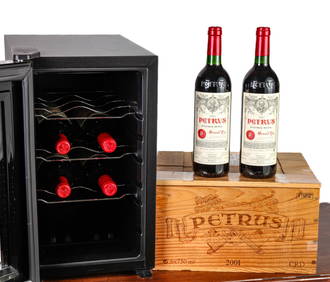
CASE OF (6) 2001 750ml BOTTLES of PETRUS POMEROLJohn McInnis Auctioneers,LLC4.6(502)See Sold PriceFeb 25, 2024
Attributed to Francis Petrus Paulus (American/ Belgian 1862-1933)Nadeau's Auction Gallery4.7(401)See Sold PriceFeb 24, 2024
Keith Haring - Ink on New York Map, Best Buddies, Inscribed, Signed, and DatedSapphire Auction Gallery4(67)See Sold PriceMar 02, 2024
Rand McNally Railroad Map Cabinet w/ 21 Railroad MapsRail & Road Auctions4.6(165)See Sold PriceMar 08, 2024
A "Red Book" of the Greatest War of History 1914North American Artifact Auctions4.6(182)See Sold PriceApr 20, 2024
Putnam - First Map of the State of Ohio by Rufus PutnamTrillium Antique Prints & Rare Books4.5(30)See Sold PriceFeb 24, 2024
Famed Black women Lorraine Hansberry and Charlotta BassPBA Galleries4.7(381)See Sold PriceMar 07, 2024
ANCIENT NORTH AFRICA Septentrionalis. Mauretania Tripolitana ARROWSMITH 1828 mapJasper524.5(9.8k)See Sold PriceFeb 28, 2024


![[Mercator (Gerard)] Japonia (1 of 1)](https://p1.liveauctioneers.com/410/16866/5605038_1_x.jpg?height=282&quality=70&version=1220278581)


![France.- Waldseemüller (Martin) [Lotharingia], (1 of 1)](https://p1.liveauctioneers.com/5458/128374/65303070_1_x.jpg?height=282&quality=70&version=1537871177)