SoldCarey, Mathew, pub. Carey's American At1 vol. Carey, Mathew, pub. Carey's American Atlas. Philadelphia, 1795. First edition. Folio, contemp. bds.; somewhat worn. Printed title-page + 21 engraved maps (20 double-page) colored in outline. TiSee Sold Price
SoldCarey's American Pocket Atlas. Phila 1796.MAP - CAREY, Mathew. Carey's American Pocket Atlas.Philadelphia: Carey, 1796. 12mo (160x90 mm). 15 engraved folding maps, only (of 19); lacks the general map of the United States, and maps oSee Sold Price
SoldMATHEW CAREY (AMERICAN, 1760-1839) MAP OF DELAWAREMATHEW CAREY (AMERICAN, 1760-1839) MAP OF DELAWARE, hand-colored engraving on paper, titled "Delaware from the best Authorities", engraved by William Barker, published Philadelphia, 1795. Modern frameSee Sold Price
SoldCarey's American Pocket Atlas, 1814Heading: Author: Carey, Mathew, publisher Title: Carey's American Pocket Atlas Place Published: Philadelphia Publisher:Mathew Carey Date Published: 1814 Description: iv, 168 pp.See Sold Price
SoldMATHEW CAREY (IRISH / AMERICAN, 1760-1839) MAP OFMATHEW CAREY (IRISH / AMERICAN, 1760-1839) MAP OF VIRGINIA, hand-colored, on laid paper, titled "A / Correct Map of / VIRGINIA" in upper right quadrant with scale; printed for Carey's "General Atlas".See Sold Price
Sold* CAREY, Mathew (1760-1839). Carey's Pocket American* CAREY, Mathew (1760-1839). Carey's Pocket American Atlas. Philadelphia: Matthew Carey, 1805. 12mo (206 x 120 mm). 20 engraved folding maps by W. Barker, J. H. Seymour, and A. Doolittle, 2 letterpresSee Sold Price
Sold(Carey, Mathew, pub.) Moore, S.S.; Jone1 vol. (Carey, Mathew, pub.) Moore, S.S.; Jones, T.W. The Traveller's Directory, or a Pocket Companion:... Philadelphia to New York, and from Philadelphia to Washington. Philadelphia: Mathew Carey, 18See Sold Price
SoldMATHEW CAREY (IRISH / AMERICAN, 1760-1839) MAP OFMATHEW CAREY (IRISH / AMERICAN, 1760-1839) MAP OF VIRGINIA, on laid paper, titled "VIRGINIA" to upper left corner, above scale, lettered "W. Baker, sculp." to lower right corner margin; after work ofSee Sold Price
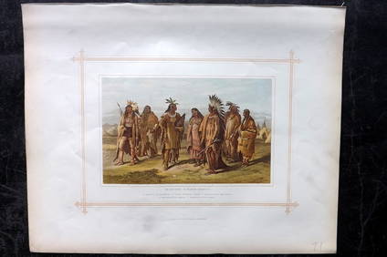
Sold[United States Constitution]. [Mathew Carey, edi[United States Constitution]. [Mathew Carey, editor]. The American Museum. See Sold Price
SoldCarey, Mathew, ed. The American Remembrancer: AnCarey, Mathew, ed. The American Remembrancer: An Impartial Collection of Essays, Resolves, Speeches , &c., Relative, or Having Affinity, to the Treaty with Great Britain. Philadelphia: Printed by HSee Sold Price
Sold1 vol. Carey, Mathew, publisher. The American Rem1 vol. Carey, Mathew, publisher. The American Remembrance; or, an Impartial Collection of Essays, Resolves, Speeches, & C, Relative,... to the Treaty With Great Britain. Philadelphia: H. Tuckniss forSee Sold Price
Extremely scarce 1814 map of Maryland by M. CareyVery elusive map of Maryland from Mathew Carey's General Atlas, the first American atlas to feature hand-colored maps. This is from the extremely scarce 1816 edition which used many of the same maps uSee Sold Price
SoldMay 1792 issue of American's 1st Literary MagazineHeading: Author: [Carey, Mathew, editor] Title: The American Museum, or, Universal Magazine, For May, 1792 Place Published: Philadelphia Publisher:Mathew Carey Date Published: 1792 DesSee Sold Price
SoldMAP, New York, CareyNew York. Mathew Carey, New York, from Carey's American Pocket Atlas, 1801 (published). Black & White. An early map of the state showing the rivers and lakes, topography, and a number of place names.See Sold Price
Sold(American Chap Book) GAY'S FABLES. Mathew Carey, P(American Chap Book) GAY'S FABLES. Mathew Carey, Philadelphia, 1808. 16mo, 122pp., complete with frontis and 5 other engarved illustrations. Orignal marbled boards with leather spine. This is the 2ndSee Sold Price
SoldUnited StatesTitle: United States Publication Date: c1805 Cartographer: CAREY, MATHEW ? Publisher: Size: 6.1Height - 7.1Width Anonymous pocket map, possibly from Carey's American Pocket atlas of 1805. Foxed and brSee Sold Price
New JerseyTitle/Content of Map: New Jersey Date: 1814 Cartographer: CAREY, MATHEW/A. DOOLITTLE Size: 7.75X5.75 From the 4th edition of Carey's American Pocket Atlas. With text. Browned. Please note that this loSee Sold Price
Sold4 TN/KY Maps, incl. Mathew Carey, 1816Two (2) Maps of Tennessee, two (2) maps of Tennessee and Kentucky, 4 items total. 1st item: Tennessee map, from American Pocket Atlas, published by Mathew Carey, Philadelphia, 1816. Copper plate engraSee Sold Price
SoldDelaware.Title/Content of Map: Delaware. Date: 1814 Cartographer: CAREY, MATHEW/A. DOOLITTLE Size: 7.75X5.75 From the 4th edition of Carey's American Pocket Atlas. With text. Browned. Please note that this lotSee Sold Price
Mathew Carey: Russian Empire in Europe & Asia MapMap: The Russian Empire in Europe and Asia Maker: Mathew Carey, Barker, W. Size: Folio - 11.30 H x 15.75 W Inches Published: Philadelphia, 1795 From: "The General Atlas for Carey's American edition ofSee Sold Price
SoldThe American Museum, 1787-8[Periodical] The American Museum,or Repository of Ancient and Modern Fugitive Pieces, & c. Prose and Poetical. Philadelphia, Mathew Carey; 1787; Philadelphia, Mathew Carey, 1788. [Vol. II: complete: 6See Sold Price
SoldMathew Carey, State of Pennsylvania, EngravingMathew Carey, State of Pennsylvania, Engraving. Date: 1795Framed in good vintage condition, with signs of yellowing and marks due to age. First atlas of America printed in America. First edition. ThesSee Sold Price
SoldMatthew Carey's American Pocket AtlasMatthew Carey's American Pocket Atlas, Philadelphia: Printed for Mathew Carey by Lang and Ustick, 1796, with hand colored in calf-backed marbled paper boards, rare copy first American pocket atlas, wiSee Sold Price
SoldCAREY, Matthew. Carey's American Pocket Atlas.CAREY, Matthew. Carey's American Pocket Atlas.Philadelphia: Printed for Mathew Carey by Lang and Ustick, 1796. 12mo (166 x 103 mm). 19 engraved folding maps (frontispiece map of the United StSee Sold Price
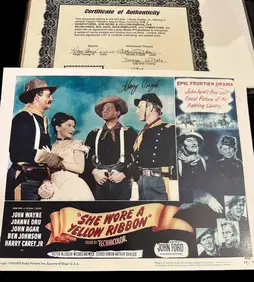
Harry Carey Jr Signed "She Wore a Yellow Ribbon" Lobby CardCowboy Joe's Antiques4.7(189)See Sold PriceFeb 27, 2024
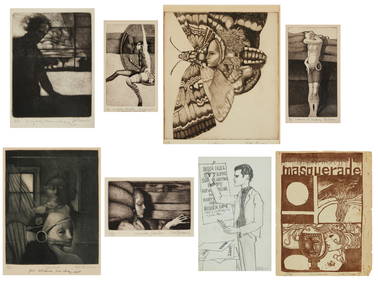
Bill Brauer (1939-2019), Eight works: Six etching and aquatints on paper, one linocut on paper, andJohn Moran Auctioneers, Inc.4.7(453)See Sold PriceFeb 27, 2024
3 Native American Paperbacks Near New ConditionNorth American Artifact Auctions4.6(182)See Sold PriceApr 20, 2024
BUFFALO by CAREY ALAN AND SANDY 1998 Fine Condition Folio Size BookNorth American Artifact Auctions4.6(182)See Sold PriceApr 20, 2024
Battle of the Nile: Disposition of the English & French Fleets, at the Commencement of the Action,Trillium Antique Prints & Rare Books4.5(30)See Sold PriceFeb 24, 2024
Putnam - First Map of the State of Ohio by Rufus PutnamTrillium Antique Prints & Rare Books4.5(30)See Sold PriceFeb 24, 2024
Carey, pub. 1796 - A Chart of the West IndiesTrillium Antique Prints & Rare Books4.5(30)See Sold PriceFeb 24, 2024
Carey, pub. 1796 - Map of the State of MarylandTrillium Antique Prints & Rare Books4.5(30)See Sold PriceFeb 24, 2024
Carey, pub. 1796 - Map of GeorgiaTrillium Antique Prints & Rare Books4.5(30)See Sold PriceFeb 24, 2024
Carey, pub. 1796 - Map of The State of South CarolinaTrillium Antique Prints & Rare Books4.5(30)See Sold PriceFeb 24, 2024
Carey, pub. 1796 - Map of KentuckyTrillium Antique Prints & Rare Books4.5(30)See Sold PriceFeb 24, 2024
Carey, pub. 1796 - Map of the Tennassee State formerly part of North Carolina (Tennessee)Trillium Antique Prints & Rare Books4.5(30)See Sold PriceFeb 24, 2024
1822 MAP of LEEWARD ISLANDS GEOGRAPHICAL STATISTICAL HISTORICAL antique 17.5x22"Jasper524.5(9.8k)See Sold PriceFeb 27, 2024
1822 MAP of SOUTH AMERICA GEOGRAPHICAL STATISTICAL HISTORICAL antique 17.5x 22"Jasper524.5(9.8k)See Sold PriceFeb 27, 2024
1822 MAP of NORTH & SOUTH AMERICA GEOGRAPHICAL STATISTICAL HISTORICAL antiqueJasper524.5(9.8k)See Sold PriceFeb 27, 2024
1822 MAP of CHILI GEOGRAPHICAL STATISTICAL HISTORICAL antique 17.5x 22" CHILEJasper524.5(9.8k)See Sold PriceFeb 27, 2024
Blackie (Pub) 1882 Folio Print. North American Indians, USAAlbion Auctions4.6(336)See Sold PriceMar 07, 2024


![[United States Constitution]. [Mathew Carey, edi (1 of 3)](https://p1.liveauctioneers.com/906/93415/47681414_1_x.jpg?height=282&quality=70&version=1473203012)