Fishing & Boating Map of the Bay, CA c1940sTitle: Fishing & Boating Map of the Bay, River & Delta Region Author: Thomas Bros. Description: 43.2x48.8 cm. (17x19¼"). Folded and affixed to red printed wrappers.The areas covered in the map includSee Sold Price
SoldFishing & Boating Map of the Bay, CA c1940sTitle: Fishing & Boating Map of the Bay, River & Delta Region Author: Thomas Bros. Description: 43.2x48.8 cm. (17x19¼"). Folded and affixed to red printed wrappers.The areas covered in the map includSee Sold Price
Fishing & Boating Map of the Bay, CA c1940sTitle: Fishing & Boating Map of the Bay, River & Delta Region Author: Thomas Bros. Description: 43.2x48.8 cm. (17x19¼"). Folded and affixed to red printed wrappers.The areas covered in the map includSee Sold Price
11 1/2 x 16 (probably late 19thC/ early 20thC) ma11 1/2 x 16 (probably late 19thC/ early 20thC) map depicting The Chesapeake Bay area ca 1585See Sold Price
SoldNautical Chart and Coastal Map of Monterey Bay, 1852Map: 1852 Nautical Chart and Coastal Map of Monterey Bay, California -- Monterey Harbor, CA from a Trigonometrical Survey Cartographer: US Coast Survey Year / Place: 1852 Map Dimensions: 13.1 x 11.7 iSee Sold Price
Nautical Chart and Coastal Map of Monterey Bay, 18521852 Nautical Chart and Coastal Map of Monterey Bay, California -- Monterey Harbor, CA from a Trigonometrical Survey. This unique chart maps the coast, town and fort of Monterey Bay. Details includedSee Sold Price
Noaa Historical Map & Chart Collection - Nautical ChartNoaa Historical Map & Chart Collection - Nautical Chart - Buzzards Bay Ca. 1974 - Sepia Tinted Size: 27 3/4 X 36 In. - This Is A Gallery Stretched Giclee Print On Canvas. The Piece Was Printed On HighSee Sold Price
Noaa Historical Map & Chart Collection - Nautical ChartNoaa Historical Map & Chart Collection - Nautical Chart - Narragansett Bay Ca. 1975 - Sepia Tinted Size: 25 1/4 X 36 In. - This Is A Gallery Stretched Giclee Print On Canvas. The Piece Was Printed OnSee Sold Price
Noaa Historical Map & Chart Collection - Nautical ChartNoaa Historical Map & Chart Collection - Nautical Chart - Massachusetts Bay Ca. 1970 - Sepia Tinted Size: 36 X 28 3/4 In. - This Is A Gallery Stretched Giclee Print On Canvas. The Piece Was Printed OnSee Sold Price
Noaa Historical Map & Chart Collection - Nautical ChartNoaa Historical Map & Chart Collection - Nautical Chart - San Francisco Bay Ca. 1975 - Sepia Tinted Size: 36 X 28 1/8 In. - This Is A Gallery Stretched Giclee Print On Canvas. The Piece Was Printed OnSee Sold Price
Noaa Historical Map & Chart Collection - Nautical ChartNoaa Historical Map & Chart Collection - Nautical Chart - Cape Cod Bay Ca. 1970 - Sepia Tinted Size: 36 X 28 1/2 In. - This Is A Gallery Stretched Giclee Print On Canvas. The Piece Was Printed On HighSee Sold Price
Noaa Historical Map & Chart Collection - Nautical ChartNoaa Historical Map & Chart Collection - Nautical Chart - San Diego Bay Ca. 1974 - Sepia Tinted Size: 36 X 27 In. - This Is A Gallery Stretched Giclee Print On Canvas. The Piece Was Printed On High QuSee Sold Price
Sold2 prints & framed fishing map: "The Last Dance at Pin2 prints & framed fishing map: "The Last Dance at Pin Oak" dated 1981 artist signed by Jack Boynton, "Bay Water Specks" artist signed by Wells 94/125See Sold Price
SoldOriginal American Regionalism Painting Morro Bay CAOriginal American Regionalism Painting Morro Bay California Fishing Boat Abstract Mixed Media Painting on Canvas. 55 x 27 1/2 x 2 inches. We pack & Ship this item for you. We take care of the shippingSee Sold Price
Original American Regionalism Painting Morro Bay CAOriginal American Regionalism Painting Morro Bay California Fishing Boat Abstract Mixed Media Painting on Canvas. 55 x 27 1/2 x 2 inches. We pack & Ship this item for you. We take care of the shippingSee Sold Price
Original American Regionalism Painting Morro Bay CAOriginal American Regionalism Painting Morro Bay California Fishing Boat Abstract Mixed Media Painting on Canvas. 55 x 27 1/2 x 2 inches. We pack & Ship this item for you. We take care of the shippingSee Sold Price
Original American Regionalism Painting Morro Bay CAOriginal American Regionalism Painting Morro Bay California Fishing Boat Abstract Mixed Media Painting on Canvas. 55 x 27 1/2 x 2 inches. We pack & Ship this item for you. We take care of the shippingSee Sold Price
SoldMaps and Books of S.F. Bay Area (120358)Lot of 6. 1. Sunset Sportsman[x=#8217/]s Atlas. S.F. Bay and Delta Area. 1955. Information on fishing, maps of boat liveries and hunting. Detailed maps. 2. The San Quentin Story by Warden Clinton T. DSee Sold Price
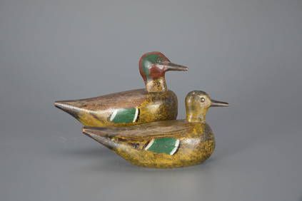
SoldRobert Capriola Bluebill Drake Duck Decoy, Humbolt Bay,Robert Capriola Bluebill Drake Duck Decoy, Humbolt Bay, CA, Glass Eyes, Solid Body, Excellent Original Paint with Nice Combing Detail, From his 1980 Personal Rig, Turned Heads, makers RC brand on bottSee Sold Price
SoldRobert Capriola pair of Canvasback Duck Decoys, HumboltRobert Capriola pair of Canvasback Duck Decoys, Humbolt Bay, CA, Glass Eyes, Hollow Bodies, Good Original Paint with Nice Combing Detail and a few shot marks, From his 1984 Personal Rig, Turned Heads,See Sold Price
SoldTexas Map with Inset of Galveston Bay, by C. Flemming,Texas Map with Inset of Galveston Bay, by C. Flemming, Ca 1845 Flemming, Carl. Texas. Glogau (formerly Silesia, now in Poland): C. Flemming, ca 1845. Overall 14 x 17.5 in., neat lines, 12.5 x 15.5 iSee Sold Price
Noaa Historical Map & Chart Collection - Nautical ChartNoaa Historical Map & Chart Collection - Nautical Chart - Tampa Bay - Northern Part Ca. 1975 - Sepia Tinted Size: 36 X 32 In. - This Is A Gallery Stretched Giclee Print On Canvas. The Piece Was PrinteSee Sold Price
SoldGeorge Blevins Decoy. Alexandria Bay, NY. Ca. 1920George Blevins Decoy. Alexandria Bay, NY. Ca. 1920. 6 1/2" x 6" x 13 1/2"See Sold Price
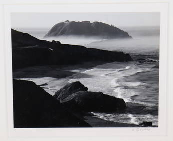
Si Chen Yuan (1911-1974 Monterey, CA)"Monterey Bay Fishing Boats" Oil on masonite Signed lower right: S.C. Yuan, titled on a gum label affixed verso 16" H x 20" W Provenance: James J. Rieser Fine Art, Carmel, CASee Sold Price
Green-Winged Teal Pair by Gottlieb Schmid (1875-1957)Copley Fine Art Auctions4.5(40)See Sold PriceFeb 24, 2024
Canvasback Decoy by Gottlieb Schmid (1875-1957)Copley Fine Art Auctions4.5(40)See Sold PriceFeb 24, 2024
LARGE LATE 17TH C. DUTCH CHART OF CANADA, GREAT LAKES, NEW FRANCE, LABRADOR, HUDSON BAY, BY PIERREThomaston Place Auction Galleries4.4(389)See Sold PriceFeb 24, 2024
EARLY 18TH C. DUTCH CHART OF PACIFIC OCEAN BY FREDERIK DE WIT (1629-1706) WITH CALIFORNIA AS ANThomaston Place Auction Galleries4.4(389)See Sold PriceFeb 24, 2024
EARLY 18TH C. MAP OF ITALY, FRAMEDThomaston Place Auction Galleries4.4(389)See Sold PriceFeb 24, 2024
LATE 16TH C. MAP OF SCOTLAND BY MERCATOR, FRAMEDThomaston Place Auction Galleries4.4(389)See Sold PriceFeb 24, 2024
An Antique Chinese Blue and White Small Porcelain Vase with Fishing SceneNeo FineArts Inc4.4(13)See Sold PriceFeb 25, 2024
Jules Andre Smith, Robin Hood's BayLotus International Auctions, LLC4.6(153)See Sold PriceMar 03, 2024
[ARCTIC]. BOWEN, Emanuel. A New & Accurate Map of the North...Potter & Potter Auctions4.6(544)See Sold PriceMar 07, 2024
GUEVARA, Ernesto “Che” (1928-1967) and CASTRO, Fidel Alejan...Potter & Potter Auctions4.6(544)See Sold PriceMar 07, 2024
[MAPS]. DUFOUR, Auguste-Henri (1795-1865). Bound Volume of ...Potter & Potter Auctions4.6(544)See Sold PriceMar 07, 2024
[MAP]. [ALBRIZZI, Giambatista, 1698-1777]. Carta Geografica...Potter & Potter Auctions4.6(544)See Sold PriceMar 07, 2024
[MAP]. NICHOLLS, Sutton (1668-1729). An Epitome of Sr. Will...Potter & Potter Auctions4.6(544)See Sold PriceMar 07, 2024
[BASEBALL]. Group of Seven Real Photo Postcards of Minor Le...Potter & Potter Auctions4.6(544)See Sold PriceMar 07, 2024
ENGLISH BRASS ARMY & NAVY FLY FISHING REEL.Amelia Jeffers, Auctioneers & Appraisers4.5(116)See Sold PriceMar 08, 2024
STAR WARS: A NEW HOPE (1977) - Framed Hand-Drawn Joe Johnston Docking Bay StoryboardPropstore4.2(6)See Sold PriceMar 13, 2024
Fifteen American Fiddleback Coin Silver Spoons by Various MakersGray's Auctioneers4.5(187)See Sold PriceMar 06, 2024
Perry, Matthew C. 1856 Large Map. Shah Bay, Lew Chew I. JapanAlbion Auctions4.6(341)See Sold PriceMar 01, 2024
Robert de Vaugondy - Map of Canada - Mer de l' Ouest or Sea of the West and a Northwest PassageProverde Auctions4.3(3)See Sold PriceFeb 28, 2024


![[ARCTIC]. BOWEN, Emanuel. A New & Accurate Map of the North... (1 of 1)](https://p1.liveauctioneers.com/928/318880/171360917_1_x.jpg?height=282&quality=70&version=1707501302)

![[MAPS]. DUFOUR, Auguste-Henri (1795-1865). Bound Volume of ... (1 of 2)](https://p1.liveauctioneers.com/928/318880/171361279_1_x.jpg?height=282&quality=70&version=1707501302)
![[MAP]. [ALBRIZZI, Giambatista, 1698-1777]. Carta Geografica... (1 of 1)](https://p1.liveauctioneers.com/928/318880/171361280_1_x.jpg?height=282&quality=70&version=1707501302)
![[MAP]. NICHOLLS, Sutton (1668-1729). An Epitome of Sr. Will... (1 of 1)](https://p1.liveauctioneers.com/928/318880/171361281_1_x.jpg?height=282&quality=70&version=1707501302)
![[BASEBALL]. Group of Seven Real Photo Postcards of Minor Le... (1 of 2)](https://p1.liveauctioneers.com/928/318880/171361375_1_x.jpg?height=282&quality=70&version=1707501302)