Map Of The State Of Texas... J. H. Young, 1859.[United States/Texas]. Map Of The State Of Texas From The Latest Authorities. By J. H. Young. Published by Charles Desilver. Philadelphia. 1859. Eng. By J. L. Hazzard. Map number in margin: “25.”See Sold Price
Scarce Cowperthwait, Desilver, Butler map of TexasScarce map of Texas by J.H. Young. “Map of the State of Texas from the Latest Authorities by J. H. Young.” 1850 map from an early 1855 edition of the Cowperthwait, Desilver & Butler New UniversalSee Sold Price
SoldScarce Cowperthwait, Desilver, Butler map of TexasScarce map of Texas by J.H. Young. “Map of the State of Texas from the Latest Authorities by J. H. Young.” 1850 map from an early 1855 edition of the Cowperthwait, Desilver & Butler New UniverSee Sold Price
SoldYOUNG, J[ames] H[amilton]. Map of Texas109. [MAP]. YOUNG, J[ames] H[amilton]. Map of the State of Texas from the Latest Authorities, by J. H. Young. Cowperthwait, DeSilver & Butler: Philadelphia. 1854. J. L. Hazzard sculp. [below neatSee Sold Price
SoldYoung, J[ames] H[amilton]. Map of the State of TX80. [MAP]. YOUNG, J[ames] H[amilton]. Map of the State of Texas from the Latest Authorities. By J. H. Young. Published by Charles DeSilver Philadelphia....1858. Eng. by J[ohn] L. Hazzard. [at bottom bSee Sold Price
YOUNG. Map of the State of Texas....Handsome Texas Pocket Map in Superb Condition 376. [MAP]. YOUNG, J[ames] H[amilton]. Map of the State of Texas from the LaSee Sold Price
[Samuel Augustus Mitchell.] Map of the State of[Samuel Augustus Mitchell.] Map of the State of Texas from the Latest Authorities by J. H. Young. Philadelphia: Cowperthwait, Desilver & Butler, 1854. Hand-colored folding map, 16" x 13". "EnteredSee Sold Price
[Samuel Augustus Mitchell.] Map of the State of[Samuel Augustus Mitchell.] Map of the State of Texas from the Latest Authorities by J. H. Young. Philadelphia: Cowperthwait, Desilver & Butler, 1854. Hand-colored folding map, 16" x 13". "EnteredSee Sold Price
SoldJ. H. YOUNG, MAP OF THE STATE OF TEXAS, PhiladelphJ. H. YOUNG, MAP OF THE STATE OF TEXAS, Philadelphia: H. Cowperthwait & Co., 1857, shows Texas with good detail throughout, depicts topographical information with clear precision, marking towns, riverSee Sold Price
SoldAN ANTIQUE MAP, "Map of the State of Texas," CIRCAAN ANTIQUE MAP, "Map of the State of Texas," CIRCA 1852, hand colored engraving on paper, "From the Latest Authorities, By J.H. Young," and "Published by Thomas, Cowperthwait & Co., Philadelphia." 12See Sold Price
SoldJ.H. Young Texas Map, 1856Map of the State of Texas, by James Hamilton Young, engraved by J.L. Hazard, published in A NEW UNIVERSAL ATLAS, Charles Desilver, Philadelphia, 1856. Steel plate engraving with hand coloring depictinSee Sold Price
SoldAN ANTIQUE ANTEBELLUM MAP, "Map of the State of Texas,"AN ANTIQUE ANTEBELLUM MAP, "Map of the State of Texas," PHILADELPHIA, CIRCA 1852, hand colored lithograph on paper, a page fragment from an atlas, no. 25, by J.H. Young, published by Thomas CowperthwaSee Sold Price
Sold1852 S.A. MITCHELL MAP OF THE STATE OF TEXASFramed "Map of the State of Texas, Engraved to Illustrate Mitchell's School and Family Geography", 1852 by S.A. Mitchell (Samuel Augustus Mitchell, Philadelphia, 1790-1868), engraved by J.H. Young, haSee Sold Price
SoldMITCHELL'S MAP OF THE STATE OF TEXAS, 1852Framed "Map of the State of Texas, Engraved to Illustrate Mitchell's School and Family Geography", 1852 by S.A. Mitchell (Samuel Augustus Mitchell, Philadelphia, 1790-1868), engraved by J.H. Young, haSee Sold Price
Sold(TEXAS.) Young, J. H. A New Map of Texas with(TEXAS.) Young, J. H. A New Map of Texas with the Contiguous American & Mexican States. Engraved folding pocket map, 320x390 mm sheet size; Texas entirely colored, border areas colored in outline; smaSee Sold Price
Sold(TEXAS.) Young, J. H. A New Map of Texas with(TEXAS.) Young, J. H. A New Map of Texas with the Contiguous American & Mexican States. Engraved folding pocket map, 330x400 mm sheet size; Texas entirely colored, border areas colored in outline; 50xSee Sold Price
Mitchell's Reference & Distance Map of the U.S. 1846Mitchell's Reference & Distance Map of the United States by J.H. Young, with Inset Map of Texas, Oregon, and California, 1846 Mitchell’s Reference & Distance Map of the United States. Engraved bySee Sold Price
SoldSamuel Augustus Mitchell. New Map of Texas withSamuel Augustus Mitchell. New Map of Texas with the Contiguous American & Mexican States, 1836 by J. H. Young. Philadelphia: S. Augustus Mitchell, 1836. Brightly colored engraved map, 15.5" x 13".See Sold Price
SoldAN ANTIQUE LATE REPUBLIC OF TEXAS MAP, "New Map ofAN ANTIQUE LATE REPUBLIC OF TEXAS MAP, "New Map of Texas with the Contiguous American & Mexican States," PHILADELPHIA, 1845, engraved by J.H. Young, published by S. Augustus Mitchell, "Sold by MitchelSee Sold Price
1837 Issue of the Young-Mitchell Map of Texas1837 Issue of the Young-Mitchell Map of the Republic of Texas 375. [MAP]. YOUNG, J[ames] H[amilton]. A New Map of TexasSee Sold Price
SoldPre-Civil War Map of Texas, J. H. Young 1858Map of Texas by J. H. Young issued in a Mitchell school atlas not long after Texas assumed its current boundaries. Most of the towns were still in the east but there were some western settlements. TheSee Sold Price
Sold(2) MAP OF TEXAS, JH YOUNG & FRAMED MARINE PRINTFramed prints, comprising: (1) colored map of Texas, most likely 20th c., after the original by J.H. Young, sight: 13.25"h, 16"w, overall: 21"h, 23.75"w; (1) print laid on board, Boat at Sea, signed iSee Sold Price
SoldNew Map of the State of TEXAS J H Colton and Co.New Map of the State of Texas Handcolored map Sight: 17 x 25.50 inches/ 43.2 x 64.8 centimeters Published by J H Colton and Co. Frame: 24.75 x 32.50 inches/ 62.8 x 82.6 centimeters In good condition:See Sold Price
Map of the United States by J.H. YoungPublication Date: 1841 Title: Map of the United States by J.H. Young Cartographer: YOUNG, J.H. Publisher: S. AUGUSTUS MITCHELL Height: 43.3 Width: 34.3 Allegorical vignette view upper center by W. MasSee Sold Price
19thc Colton Map, Comparitive Size of Lakes & IslandsConnoisseur Auctions3.9(335)See Sold PriceFeb 24, 2024
1952 J.F.K for US SENATE CAMPAIGN MATERIALSJohn McInnis Auctioneers,LLC4.6(504)See Sold PriceFeb 25, 2024
United States Map with American Flag 3-D Wall Mount PaintingWeatherham Estate Treasures3.9(157)See Sold PriceFeb 29, 2024
Vintage County Map Of NY State Plate EngravingThe Benefit Shop Foundation Inc.4.3(2.9k)See Sold PriceFeb 28, 2024
[ENSLAVEMENT & ABOLITION]. 3 works related to enslavement, comprising:Freeman's | Hindman4.4(1.6k)See Sold PriceFeb 27, 2024
Womens Vintage Estate 18K Gold Hilcox British Wedding Band RingMannys Jewelry4.6(333)See Sold PriceMar 14, 2024
Official Letters From state Leaders from the 80sRapid Estate Liquidators and Auction Gallery4.5(1.1k)See Sold PriceFeb 24, 2024
Rare 19thc Colton Map, Argentine Republic, Chile, Uruguay, PataguayConnoisseur Auctions3.9(335)See Sold PriceMar 16, 2024
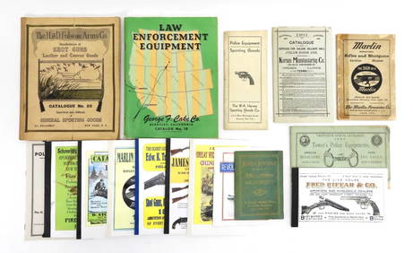
16PC Police Equipment & Sporting Goods CatalogsBruneau & Co. Auctioneers4.5(491)See Sold PriceMar 18, 2024


![YOUNG, J[ames] H[amilton]. Map of Texas (1 of 1)](https://p1.liveauctioneers.com/514/10700/2580000_1_x.jpg?height=282&quality=70&version=1160418848)
![Young, J[ames] H[amilton]. Map of the State of TX (1 of 5)](https://p1.liveauctioneers.com/514/11740/3078851_1_x.jpg?height=282&quality=70&version=1171465640)

![[Samuel Augustus Mitchell.] Map of the State of (1 of 2)](https://p1.liveauctioneers.com/906/165466/83729359_1_x.jpg?height=282&quality=70&version=1586352505)
![[Samuel Augustus Mitchell.] Map of the State of (1 of 2)](https://p1.liveauctioneers.com/906/151769/76674393_1_x.jpg?height=282&quality=70&version=1570484207)


![[ENSLAVEMENT & ABOLITION]. 3 works related to enslavement, comprising: (1 of 4)](https://p1.liveauctioneers.com/197/319238/171468080_1_x.jpg?height=282&quality=70&version=1707520367)