ATLAS of ANTIENT GEOGRAPHY by SAMUEL BUTLER 1843John McInnis Auctioneers,LLC4.6(502)See Sold PriceFeb 24, 2024
18TH C. ANTIQUE MAP: FRENCH & INDIAN WAR, FRAMEDThomaston Place Auction Galleries4.4(386)See Sold PriceFeb 24, 2024
Rand McNally Railroad Map Cabinet w/ 21 Railroad MapsRail & Road Auctions4.6(165)See Sold PriceMar 08, 2024
Keith Haring - Ink on New York Map, Best Buddies, Inscribed, Signed, and DatedSapphire Auction Gallery4(67)See Sold PriceMar 02, 2024
LATE 17TH C. FRENCH MAP OF THE NEW WORLD BY ALEXIS-HUBERT JAILLOT (1632-1712)Thomaston Place Auction Galleries4.4(386)See Sold PriceFeb 24, 2024
Central Railroad of New Jersey Map of Sandy Hook Route-ca. 1903JM Hobby Supply and Railroad Artifact Auctions4.4(126)See Sold PriceFeb 24, 2024
Lot of Six Mixed Atlas Box Cars-HO Scale-New in BoxJM Hobby Supply and Railroad Artifact Auctions4.4(126)See Sold PriceFeb 25, 2024
Rand McNally/Santa Fe Railroad Map of Iowa-1912JM Hobby Supply and Railroad Artifact Auctions4.4(126)See Sold PriceFeb 24, 2024
NICOLAES VISSCHER (NETHERLANDS, 1618-1709) MAP OF THE NEW WORLDThomaston Place Auction Galleries4.4(386)See Sold PriceFeb 24, 2024
17TH C. WORLD MAP BY NICOLAES VISSCHER (NETHERLANDS, 1618-1709)Thomaston Place Auction Galleries4.4(386)See Sold PriceFeb 24, 2024
Lot of Six Mixed Atlas Cabooses-HO Scale-New in BoxJM Hobby Supply and Railroad Artifact Auctions4.4(126)See Sold PriceFeb 25, 2024
Partie Meridionale Du Royaume De Naples,Publication Date: 1757 Title: Partie Meridionale Du Royaume De Naples, Cartographer: ROBERT DE VAUGONDY, GILLES (1686-1766) Publisher: LES AUTEURS ET BOUDET Height: 18.75 Width: 23.1 ou se trouvent laSee Sold Price
Partie Meridionale Du Royaume De Naples,Publication Date: 1757 Title: Partie Meridionale Du Royaume De Naples, Cartographer: ROBERT DE VAUGONDY, GILLES (1686-1766) Publisher: LES AUTEURS ET BOUDET Height: 18.75 Width: 23.1 ou se trouvent laSee Sold Price
Partie Meridionale Du Royaume De Naples,Title/Content of Map: Partie Meridionale Du Royaume De Naples, Cartographer: ROBERT DE VAUGONDY, GILLES (1686-1766) Height (inches): 18.75 Width (inches): 23.1Year: 1757 ou se trouvent la Calabre et ISee Sold Price
SoldCOVENS and MORTIER. Partie Meridionale du RoyaCOVENS and MORTIER. Partie Meridionale du Royaume de Naples. Engraved two-sheet folding map, 455x735 mm, wide margins; hand-colored in outline; several short repairs at edges. Amsterdam, circa 1720 ASee Sold Price
Partie Méridionale du Royaume de Naples & SicileTITLE/CONTENT OF MAP: Partie Méridionale du Royaume de Naples et celui de l'isle de Sicile [The southern part of the Kingdom of Naples and the island of Sicily] DATE PRINTED: 1789 IMAGE SIZE: ApproxSee Sold Price
1780 BONNE RIGOBERT (1725 - 1795) INCISIONE con1780 BONNE RIGOBERT (1725 - 1795) INCISIONE con coloritura coeva "Partie meridionale du royaume de Naples est celui de l'isle de Sicile" (cm 24 x 34). Misure: cm 41 x 28,5See Sold Price
Partie Méridionale du Royaume de Naples & SicileTITLE/CONTENT OF MAP: Partie Méridionale du Royaume de Naples et celui de l'isle de Sicile [The southern part of the Kingdom of Naples and the island of Sicily] The top image on the right hand side sSee Sold Price
1748 DE VAUGONDY GILLES ROBERT (1688 - 1766) de1748 DE VAUGONDY GILLES ROBERT (1688 - 1766) de vaugondy didier robert (1723 - 1786) INCISIONE in bianco e nero "Partie meridionale du royaume de Naples, ou se trouvent la Calabre et la Sicile" (cm 16See Sold Price
PARTIE MERIDIONALE DU ROYAUME DE PORTUGAL'. Algarve. DE VAUGONDY c1750 mapTITLE/CONTENT OF MAP: 'Partie Meridionale du Royaume de Portugal' The map shows Southern Portugal, with the adjacent part of Spain, including Lisbon, the Algarve, Alentejo and most of Estremadura DATESee Sold Price
"Partie meridionale du Royaume de Portugal". Algarve.TITLE/CONTENT OF MAP: 'Partie meridionale du Royaume de Portugal. Par le Sr. Bellin, Ingénieur de la Marine et du Dépost des Plans. À Venise par Francois Santini Rue Ste. Justine pres de l'ESee Sold Price
Partie meridionale du Royaume de Portugal. Algarve.TITLE/CONTENT OF MAP: 'Partie meridionale du Royaume de Portugal. Par le Sr. Bellin, Ingénieur de la Marine et du Dépost des Plans. À Venise par Francois Santini Rue Ste. Justine pres de l'ESee Sold Price
SoldSanson d'Abbeville (N) HongrieSanson d'Abbeville (Nicolas) Partie Meridionale Du Royaume De Hongrie, engraved map with outline hand-colouring, 365 x 585mm., central vertical fold, with faint ruled pencil lines, faint brownSee Sold Price
SoldRobert de Vaugondy (G & D) PortugalRobert de Vaugondy (Gilles & Didier) Partie Septrionale du Royaume de Portugal; and Partie Méridionale du Royaume de Portugal, northern and southern Portugal,2 engraved maps with orignal hand-See Sold Price
1750 DE VAUGONDY GILLES ROBEERT (1688 - 1766) DE1750 DE VAUGONDY GILLES ROBEERT (1688 - 1766) DE VAUGONDY DIDIER ROBERT (1723 - 1786) INCISIONE con coloritura coeva "Prtie meridionale du royaume de Naples, ou se trouvent la calabre et l'Isle et RoySee Sold Price
Partie Méridionale du Royaume Portugal. Southern Algarve. VAUGONDY 1751 mapTITLE OF MAP (NOT PRINTED ON THE PAGE):'Partie Méridionale du Royaume de Portugal, par le Sr. Robert, Géographe ordinaire du Roy. Avec Privilege' DATE PRINTED: 1751 IMAGE SIZE: Approx 50.0 xSee Sold Price
Partie Septentrionale Du Royaume De Naples,Publication Date: 1757 Title: Partie Septentrionale Du Royaume De Naples, Cartographer: ROBERT DE VAUGONDY, GILLES (1686-1766) Publisher: LES AUTEURS ET BOUDET Height: 18.75 Width: 23 ... 1750." CartoSee Sold Price
SoldPartie Septentrionale Du Royaume De Naples. 1779.[Italy] Vaugondy, Robert de. “Partie Septentrionale Du Royaume De Naples." Venice, P. Santini,1779. Engraved map. 23” x 18 3/4”. Hand-colored outline. Pedley 360._x000D_ Condition VeSee Sold Price
Partie septentrionale du Royaume de Naples'. Southern Italy. VAUGONDY 1750 mapTITLE OF THE MAP: 'Partie septentrionale du Royaume de Naples [Northern part of the Kingdom of Naples]' Includes Puglia, Basilicata, Campania, Molise and part of Abruzzo, with the Adriatic, Gulf of TaSee Sold Price
Partie Septentrionale Du Royaume De Naples,Publication Date: 1757 Title: Partie Septentrionale Du Royaume De Naples, Cartographer: ROBERT DE VAUGONDY, GILLES (1686-1766) Publisher: LES AUTEURS ET BOUDET Height: 18.75 Width: 23 ... 1750." CartoSee Sold Price
Partie Septentrionale Du Royaume De Naples,Title/Content of Map: Partie Septentrionale Du Royaume De Naples, Date: 1757 Cartographer: ROBERT DE VAUGONDY, GILLES (1686-1766) Size: 18.75X23 ... 1750." Cartouche. From the monumental Atlas UniversSee Sold Price
[maps] Didier, Royaume de NaplesVaugondy Didier Robert (de), Partie septentrionale du Royaume de Naples. 1750 ca. Incisione in rame con coloritura dei confini. mm 495x630. Foglio: mm 560x795. Titolo entro cartiglio in alto a deSee Sold Price
SoldDe Vaugondy, 2 maps of Italy, 1750[Italy]. Robert de Vaugondy. 2 double-page engraved maps. ++ Partie Septentrionale Du Royaume De Naples. ++ Partie Meridinale Du Royaume De Naples: Ou se trouvent la Calabre et L'Isle et Royaume de SiSee Sold Price
SoldGilles Robert de Vaugondy (1688-1766), "PartieGilles Robert de Vaugondy (1688-1766), "Partie Septentrionale du Royaume de Naples," 1750, handcolored, H. - 18 in., W. - 24 in.See Sold Price
SoldCartografia.Cartografia. Interessante insieme 25 di incisioni raffiguranti vedute di città e carte geografiche, tra le quali la Partie Méridionale du Rouaume de Naples del cartografo Gilles Robert de VaugSee Sold Price
LARGE LATE 17TH C. DUTCH CHART OF CANADA, GREAT LAKES, NEW FRANCE, LABRADOR, HUDSON BAY, BY PIERREThomaston Place Auction Galleries4.4(386)See Sold PriceFeb 24, 2024
RIGOBERT BONNE c1787 Original Colored Map Germany & Region 15" x 12"Luis Porretta Fine Arts4.3(10)See Sold PriceMar 02, 2024
SAVANN THAV (artiste cambodgien né en 1956) : Composition au fond rouge jaune et rouge. Toile. 100Valoir Pousse-Cornet4.3(4)See Sold PriceFeb 24, 2024
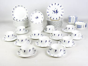
Jean PICART LE DOUX (1902-1982) d'après : Partie de service à thé-café et à dessert enValoir Pousse-Cornet4.3(4)See Sold PriceFeb 24, 2024
Elisabeth GAROUSTE (née en 1949) et Mattia BONETTI (né en 1952) : Partie de service à caféValoir Pousse-Cornet4.3(4)See Sold PriceFeb 24, 2024
Hermes PHW Bridado Shoulder Bag Evercolor Leather Jaune De Naples YellowBidhaus4.3(747)See Sold PriceFeb 28, 2024
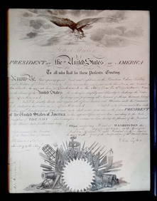
TYLER, John, 10e président des États-Unis d’Amérique / 10th President of theIEGOR Auctions4.2(133)See Sold PriceFeb 28, 2024
Edouard Vuillard La Partie De Dames Custom Framed PrintMynt Auctions4.6(680)See Sold PriceFeb 26, 2024
HENRI DE TOULOUSE-LAUTREC (1864-1901) LITHOGRAPH TITLED PARTIE DE CAMPAGNE, 22IN x 26IN (56cm xThe Rug Life4.3(12)See Sold PriceMar 07, 2024
"La Partie de Campagne", Charles Sorlier Litho.Direct Auction Galleries 4.7(322)See Sold PriceFeb 24, 2024
1764 Bellin Map of Southern Portion of Martinique -- Partie Meridionale de la MartiniqueJasper524.5(9.8k)See Sold PriceFeb 27, 2024
Afrique. Partie du Désert de Sahara #13. Mauritania Mali. VANDERMAELEN 1827 mapJasper524.5(9.8k)See Sold PriceFeb 28, 2024
Partie de la Coste d'Afrique depuis Tanit…' Southern Mauritania BELLIN 1746 mapJasper524.5(9.8k)See Sold PriceFeb 28, 2024
Partie de la Coste d'Afrique'. Southern Mauritania BELLIN/SCHLEY 1747 old mapJasper524.5(9.8k)See Sold PriceFeb 28, 2024
NORTH AFRICA. 'Biledulgerid', a former North African country. MALLET 1683 mapJasper524.5(9.8k)See Sold PriceFeb 28, 2024
Partie Occidentale de l’Afrique. West Africa coast Canary islands BONNE 1788 mapJasper524.5(9.8k)See Sold PriceFeb 28, 2024
NORTH AFRICA. Barbary. Morocco Tunisia Libya Egypt. 'Barbarie'. MALLET 1683 mapJasper524.5(9.8k)See Sold PriceFeb 28, 2024
Partie Occidentale de l'Ancien Continent… W Africa Macaronesia. BONNE 1780 mapJasper524.5(9.8k)See Sold PriceFeb 28, 2024
VAN DONGEN KEES: (1877-1968)International Autograph Auctions Europe S.L.4.5(52)See Sold PriceMar 14, 2024


![[maps] Didier, Royaume de Naples (1 of 1)](https://p1.liveauctioneers.com/1306/122788/62497235_1_x.jpg?height=282&quality=70&version=1527839290)