SoldHand-colored map “Vue de Boston”, c.1775, Grave pHand-colored map “Vue de Boston”, c.1775, Grave par Francis Xau Habemann. 13.25”x18.25”See Sold Price
SoldHand-colored map, c.1775, “Vue de Boston”, GraveHand-colored map, c.1775, “Vue de Boston”, Grave par Francois Xau Habermann. 14.25”x19”See Sold Price
Sold(2) antique maps of Europe by Nicolas De Fer(2) antique maps of Europe by Nicolas De Fer, "Les Suisses, Leurs Sujets et Leurs Alliez", black and white map, 1715 and "Le Golfe De Venise", hand-colored map, 1716, by Nicolas De Fer and P. StarckmaSee Sold Price
SoldVUE DE BOSTON…,HAND COLORED ENGR, C.1740Title: Vue de Boston - Vue de la Rue du Roi vers la Porte de la Campagne a Boston, Printmaker: Francois Xavier Habermann, Date: C.1740, Medium: Hand-colored engraving, Paper size: 12 x 16, Inscribed:See Sold Price
Sold1 piece. Hand-Colored Engraved Map. Covens, Johan1 piece. Hand-Colored Engraved Map. Covens, Johannes; Mortier, Cornelis. Novaeau Plan de Gibraltar, avec ces Fortifications"; "Vue de la Ville de Gibraltar..."; "Nouvelle Carte d'une Partie, d'EspagneSee Sold Price
SoldFRENCH, 18TH CENTURYTwo hand colored engravings including a map, La Mer Aquitanique, together with Vue de L'hotel de Ville de Paris, framed.See Sold Price
123: ENGRAVED/HAND COLORED MAPENGRAVED/HAND COLORED MAP, ISLES D'AMERIQUE DITES CARIBES ET ANTILLES ET DE BARLOVENTO, P. DU VAL d'ABBEVILLE 1677. PLATE 13 1/2 X 10 1/4; SHEET 23 X 17See Sold Price
Sold18th century engraved Vue d'Optiques(Lot of 3) Framed handcolored ''Vue d'Optiques'' engravings by Francois Xavier Habermann (French 1721-1796), depicting views of Boston: ''Vue de la Rue de de la Maison de Ville a Boston,'' ''Vue de laSee Sold Price
Sold18th century engraved Vue d'Optiques(Lot of 3) Framed handcolored ''Vue d'Optiques'' engravings by Francois Xavier Habermann (French 1721-1796), depicting views of Boston: ''Vue de la Rue de de la Maison de Ville a Boston,'' ''Vue de laSee Sold Price
Sold1750 Map Isles de Saint Dominque, MartiniqueHand-colored map, dated 1750, Isles de Saint Dominique on Hispaniola et de la Martinique, sold by Goodspeeds of Boston, 19" x 20 1/2".See Sold Price
Sold(MAP) SANTINI, P. Estat de la Seigneuri et republique(MAP) SANTINI, P. Estat de la Seigneurie et republique de Venise en Terre ferme. Venice: M. Remondini, 1776. Engraved map, hand-colored in outline. [Together with:] Le Frioul. Dresse su la carte recemSee Sold Price
(MAP) SANTINI, P. Estat de la Seigneuri et republique(MAP) SANTINI, P. Estat de la Seigneurie et republique de Venise en Terre ferme. Venice: M. Remondini, 1776. Engraved map, hand-colored in outline. [Together with:] Le Frioul. Dresse su la carte recemSee Sold Price
Early hand colored map of France entitled "CIVITASEarly hand colored map of France entitled "CIVITAS LEUCORUM SIVE PAGUS TULLENSIS AUCTORE GUILL: de L' Isle. AMSTELODOAMI Apud P. MORTIER cum Prviliegio." (Map maker Pierre Mortier, Netherlands 1661-17See Sold Price
SoldAlexis Hubert Jaillot (1632-1712), hand coloredAlexis Hubert Jaillot (1632-1712), hand colored engraved map 1693, Le Golfe De Venise, Avec Ses Principaux Caps, Promontoires, and Ports de Mer Les Nouveaux du P Corneli Autres par le sanson, plateSee Sold Price
SoldFOUR 18TH CENTURY HAND-COLORED FRENCH ENGRAVINGSFOUR 18TH CENTURY HAND-COLORED FRENCH ENGRAVINGS "Vue du Chateau Royal de Trianon Dans le Parc de Verfaillea". Published by P Le Fautre, c1770. Title in French. Some stains and edge loss: "Vue du CourSee Sold Price
Gilles Robert de Vaugondy 1688-1766 (French)Gilles Robert de Vaugondy 1688-1766 (French) 'La Judee ou Terre Sainte- Carte de la Terre de Canaan', 1779. Par P. Santini M. Rermondi Editeur, Venice. Engraved map with hand colored borders. Relief sSee Sold Price
Sold18TH C. VUE D'OPTIQUE OF DUNKERK MAPHand colored 18th century view, titled "Vue De Dunkerque." Dimensions: (Frame) H 16" x W 20", (Sight) H 12" x W 16.5" Condition: Colors bright. Small scrape upper right.See Sold Price
Sold1700 Vue de Venisse quand on vient de la Cote de Fusine1700 Vue de Venisse quand on vient de la Cote de Fusine grave par Francois Haberman, hand colored print of Venice, 12.5 by 17 inches- some stains, foxing mostly across bottom edgeSee Sold Price
Map "de Parme et de Modene"Hand colored. P. Santinia, 1729, Venice, Italy. Approx. 20" H x 28" W unframed, 25" H x 33" W framed. Broken glass.See Sold Price
SoldTwo Framed Hand-colored Maps of the Holy Land, a pTwo Framed Hand-colored Maps of the Holy Land, a page titled Of Canaan, and a Guillelmi De L'Isle and Josepho N. De L'Isle Terrae Santae Tabula, the latter sight size 13 1/2 x 19 1/4 in.See Sold Price
SoldFOUR HANDCOLORED ENGRAVINGS OF BOSTON. French engrFOUR HANDCOLORED ENGRAVINGS OF BOSTON. French engravings on laid paper by Francois Habermann. Each shows a different location identified both in French and German (the main French title "Vue de BostonSee Sold Price
SoldBertius/Tavernier, Map 1627Bertius/Tavernier, "Carte de L'Amerique Corrigee, et augmentee, dessus toutes les aultres cy devant faictes par P. Bertius", 1627, hand-colored map, first state, based on Hondius' map of 1618, richlySee Sold Price
SoldBertius/Tavernier MapBertius/Tavernier, "Carte de L'Amerique Corrigee, et augmentee, dessus toutes les aultres cy devant faictes par P. Bertius", 1627, hand-colored map, first state, based on Hondius' map of 1618, richlySee Sold Price
SoldPhillipe Vandermaelen 19th C. LithographHand Colored. Map published 1825-1827 by Belgian publisher P. Vandermaelen showing Florida and the Bahamas noting early colonies and roads. From Vandermaelen's "Atlas Universel de Geographie." SingleSee Sold Price
MARTINET / DE VRIES Catechism of Nature 4 Vol. Set c1788 Engravings Rare!Luis Porretta Fine Arts4.3(10)See Sold PriceMar 02, 2024
LARGE LATE 17TH C. DUTCH CHART OF CANADA, GREAT LAKES, NEW FRANCE, LABRADOR, HUDSON BAY, BY PIERREThomaston Place Auction Galleries4.4(393)See Sold PriceFeb 24, 2024
EARLY 18TH C. DUTCH CHART OF PACIFIC OCEAN BY FREDERIK DE WIT (1629-1706) WITH CALIFORNIA AS ANThomaston Place Auction Galleries4.4(393)See Sold PriceFeb 24, 2024
17TH C. ANTIQUE MAP SIEGE OF LA ROCHELLE, FRANCE, FRAMEDThomaston Place Auction Galleries4.4(393)See Sold PriceFeb 24, 2024
ABRAHAM ORTELIUS (1527-1598) MAP OF ROMAN GAUL (FRANCE)Thomaston Place Auction Galleries4.4(393)See Sold PriceFeb 24, 2024
CHARLES ROLLIN c1828 Ceasar Hand Colored Africa Military MapLuis Porretta Fine Arts4.3(10)See Sold PriceMar 02, 2024
RIGOBERT BONNE c1787 Original Colored Map Germany & Region 15" x 12"Luis Porretta Fine Arts4.3(10)See Sold PriceMar 02, 2024
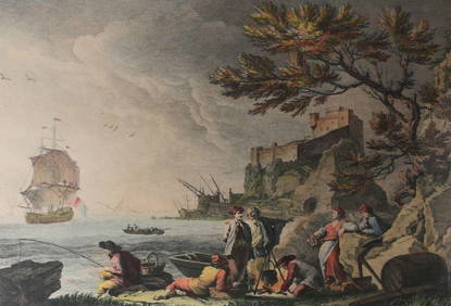
After J Vernet Engraving J Jacques Le Veau Vue des Environs de Bayonne c1750-85Global Auctions Company4.3(36)See Sold PriceMar 03, 2024
An early Dutch hand colored engraving map by Georg Balthasar Probst (1732-1801)Ostantix Auctions4.4(11)See Sold PriceFeb 27, 2024
[MAPS]. DUFOUR, Auguste-Henri (1795-1865). Bound Volume of ...Potter & Potter Auctions4.6(545)See Sold PriceMar 07, 2024
Pascal's Collection de fleurs... - Volume with 48 Originally Hand-colored LithographsTrillium Antique Prints & Rare Books4.5(32)See Sold PriceFeb 24, 2024
Italian edition of Sanson's map of North America, 1677PBA Galleries4.7(385)See Sold PriceMar 07, 2024


![[MAPS]. DUFOUR, Auguste-Henri (1795-1865). Bound Volume of ... (1 of 2)](https://p1.liveauctioneers.com/928/318880/171361279_1_x.jpg?height=282&quality=70&version=1707501302)


