SoldHand-colored map, c.1775, “Vue de Boston”, GraveHand-colored map, c.1775, “Vue de Boston”, Grave par Francois Xau Habermann. 14.25”x19”See Sold Price
SoldHand-colored map “Vue de Boston”, c.1775, Grave pHand-colored map “Vue de Boston”, c.1775, Grave par Francis Xau Habemann. 13.25”x18.25”See Sold Price
SoldVUE DE BOSTON…,HAND COLORED ENGR, C.1740Title: Vue de Boston - Vue de la Rue du Roi vers la Porte de la Campagne a Boston, Printmaker: Francois Xavier Habermann, Date: C.1740, Medium: Hand-colored engraving, Paper size: 12 x 16, Inscribed:See Sold Price
Sold1 piece. Hand-Colored Engraved Map. Covens, Johan1 piece. Hand-Colored Engraved Map. Covens, Johannes; Mortier, Cornelis. Novaeau Plan de Gibraltar, avec ces Fortifications"; "Vue de la Ville de Gibraltar..."; "Nouvelle Carte d'une Partie, d'EspagneSee Sold Price
SoldFRENCH, 18TH CENTURYTwo hand colored engravings including a map, La Mer Aquitanique, together with Vue de L'hotel de Ville de Paris, framed.See Sold Price
Sold18th century engraved Vue d'Optiques(Lot of 3) Framed handcolored ''Vue d'Optiques'' engravings by Francois Xavier Habermann (French 1721-1796), depicting views of Boston: ''Vue de la Rue de de la Maison de Ville a Boston,'' ''Vue de laSee Sold Price
Sold18th century engraved Vue d'Optiques(Lot of 3) Framed handcolored ''Vue d'Optiques'' engravings by Francois Xavier Habermann (French 1721-1796), depicting views of Boston: ''Vue de la Rue de de la Maison de Ville a Boston,'' ''Vue de laSee Sold Price
Sold1750 Map Isles de Saint Dominque, MartiniqueHand-colored map, dated 1750, Isles de Saint Dominique on Hispaniola et de la Martinique, sold by Goodspeeds of Boston, 19" x 20 1/2".See Sold Price
Sold18TH C. VUE D'OPTIQUE OF DUNKERK MAPHand colored 18th century view, titled "Vue De Dunkerque." Dimensions: (Frame) H 16" x W 20", (Sight) H 12" x W 16.5" Condition: Colors bright. Small scrape upper right.See Sold Price
Sold1700 Vue de Venisse quand on vient de la Cote de Fusine1700 Vue de Venisse quand on vient de la Cote de Fusine grave par Francois Haberman, hand colored print of Venice, 12.5 by 17 inches- some stains, foxing mostly across bottom edgeSee Sold Price
SoldFOUR HANDCOLORED ENGRAVINGS OF BOSTON. French engrFOUR HANDCOLORED ENGRAVINGS OF BOSTON. French engravings on laid paper by Francois Habermann. Each shows a different location identified both in French and German (the main French title "Vue de BostonSee Sold Price
SoldFrench & English Palace & City Views & MapFrench hand colored palace engravings (2), "Vue Meridionale de la Place Royals de Nancy" by Daumont, "Vue Perspective d'une Maison de Plaisance du Roy d'Espagne" by Basset. Plates (2) from Rapin'sSee Sold Price
SoldDe Rossi, G.48. De Rossi, G..Vue du Chateau du Pont St. Ange. A Rome. Fine engraved view of a processional heading into the Castle. 21 x 27 inches, hand-colored; rolled, scattered browning, closed tear along foldSee Sold Price
SoldRecuéil de Cartes Géographiques, Plans, Vues et Mxxxix pp. + 32 copper-engraved maps, plans & views, most double-page, a few folding, some hand-colored in outline. (4to) 9¾x7¾, original leather-backed boards. First Edition. Atlas volume to the firSee Sold Price
SoldHAND COLORED "VUE DE PHILADELPHIA"Hand colored view of Philadelphia with sailing ships. Dimensions: (Frame) H 19.75" x W 23.75" (Sight) H 12" x W 14.5" Condition: Paper age toned. A few small surface scratches upper left.See Sold Price
SoldDeroy, sc. Reproduction of Lithograph, Hand Colored, Vue de Los AngelesVue de Los Angeles. Approx. 14 x 17 3/4 in. (paper). Discoloration from previous mat. Tape residue on front 4 corners. Tape residue on back top edge. Provenance: Argosy Book Store Inc., N.Y., Oct. 20,See Sold Price
SoldHaberman: Antique View of King Street, Boston, 1770Map: Vue de Boston/Rue du Roy Cartographer: Haberman Place & Date: Augsburg / 1770s Size: 15 3/4" x 12" Condition: wash color; minor stains in margins A scarce "vue d'optique" (or magic lantern print)See Sold Price
SoldHaberman: Antique View of Boston/Old South Church, 1760Map: Vue de Boston/la Rue Grande ver l'Eglise du Sud Cartographer: Haberman Place & Date: Augsburg / 1760 (?) Size: 15 3/4" x 12" Condition: wash color; overall age toning and some browning and wrinklSee Sold Price
SoldHand Colored Map - Carte De Moscovie A. AmsterdamHand Colored Map - Carte De Moscovie A. Amsterdam chez lean Covens et ConeilleSee Sold Price
Sold1 piece. Hand-Colored Engraved Map. De1 piece. Hand-Colored Engraved Map. Delisle, Guillaume. "L'Amerique Septentrionalis." Amsterdam: Covens and Mortier, [1730]. 18 7/8 x 22 7/8 inches; 480 x 580 mm, full margins. Old outline color, cartSee Sold Price
Framed Hand Colored Map, Porto de TriesteFramed Hand Colored Map, Porto de Trieste {Dimensions of frame 25 1/4 x 27 1/4 inches} [crack to glass of frame]See Sold Price
Sold1 piece. Hand-Colored Engraved Map. De1 piece. Hand-Colored Engraved Map. Delisle, Guillaume. "Carte du Paraguay, du Chili,.." Amsterdam: Covens and Mortier, [1730]. 19 5/8 x 22 5/8 inches; 498 x 575 mm. full margins. Outline color. SomeSee Sold Price
Sold1757 hand colored map "Duche de Pomeraniae" - 29 1/1757 hand colored map "Duche de Pomeraniae" - 29 1/2 x 19 3/4See Sold Price
SoldJ.H. COLTON HAND COLORED MAP OF BOSTON, 1855Joseph Hutchins Colton, American (1800-1893). Hand-colored engraving titled "Colton's Map of Boston and Adjacent Cities". Plate No. 13 from Colton's "Atlas of the World", published by Johnson & BrowniSee Sold Price
MARTINET / DE VRIES Catechism of Nature 4 Vol. Set c1788 Engravings Rare!Luis Porretta Fine Arts4.3(10)See Sold PriceMar 02, 2024
LARGE LATE 17TH C. DUTCH CHART OF CANADA, GREAT LAKES, NEW FRANCE, LABRADOR, HUDSON BAY, BY PIERREThomaston Place Auction Galleries4.4(386)See Sold PriceFeb 24, 2024
EARLY 18TH C. DUTCH CHART OF PACIFIC OCEAN BY FREDERIK DE WIT (1629-1706) WITH CALIFORNIA AS ANThomaston Place Auction Galleries4.4(386)See Sold PriceFeb 24, 2024
17TH C. ANTIQUE MAP SIEGE OF LA ROCHELLE, FRANCE, FRAMEDThomaston Place Auction Galleries4.4(386)See Sold PriceFeb 24, 2024
ABRAHAM ORTELIUS (1527-1598) MAP OF ROMAN GAUL (FRANCE)Thomaston Place Auction Galleries4.4(386)See Sold PriceFeb 24, 2024
CHARLES ROLLIN c1828 Ceasar Hand Colored Africa Military MapLuis Porretta Fine Arts4.3(10)See Sold PriceMar 02, 2024
RIGOBERT BONNE c1787 Original Colored Map Germany & Region 15" x 12"Luis Porretta Fine Arts4.3(10)See Sold PriceMar 02, 2024
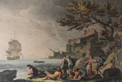
After J Vernet Engraving J Jacques Le Veau Vue des Environs de Bayonne c1750-85Global Auctions Company4.3(36)See Sold PriceMar 03, 2024
An early Dutch hand colored engraving map by Georg Balthasar Probst (1732-1801)Ostantix Auctions4.4(10)See Sold PriceFeb 27, 2024
[MAPS]. DUFOUR, Auguste-Henri (1795-1865). Bound Volume of ...Potter & Potter Auctions4.6(539)See Sold PriceMar 07, 2024
Kipling's Les plus beaux contes - 24 Engravings by Kees Van DongenTrillium Antique Prints & Rare Books4.5(30)See Sold PriceFeb 24, 2024
Pascal's Collection de fleurs... - Volume with 48 Originally Hand-colored LithographsTrillium Antique Prints & Rare Books4.5(30)See Sold PriceFeb 24, 2024
Italian edition of Sanson's map of North America, 1677PBA Galleries4.7(381)See Sold PriceMar 07, 2024


![[MAPS]. DUFOUR, Auguste-Henri (1795-1865). Bound Volume of ... (1 of 2)](https://p1.liveauctioneers.com/928/318880/171361279_1_x.jpg?height=282&quality=70&version=1707501302)


