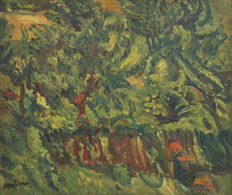
Chaim Soutine (Belarusian/French, 1893-1943) - La Petite Fille dans la VerdureFreeman's | Hindman4.5(158)See Sold PriceFeb 27, 2024
Elisabeth Frink (British, 1930-1993) - Harbinger Bird IFreeman's | Hindman4.5(158)See Sold PriceFeb 27, 2024
AMERICAN SEASCAPE PAINTING BY ROSS EMBROSE MOFFETTAntique Arena Inc.4.5(852)See Sold PriceMar 02, 2024
CHARLES HENRY GIFFORD (Massachusetts, 1839-1904), Luminist view of three sailboats in a quietEldred's4.7(409)See Sold PriceFeb 28, 2024
RARE MANHATTAN PROJECT GLASS LEADED FROM THE MANHATTAN PROJECT WORLD WAR II WW2 724 GRAMSCol. Christie Hatman Auctioneers4.5(312)See Sold PriceFeb 26, 2024
Estate Fresh Civil War Cavalry C. Roby 1863 With ScabbardRalph Fontaine Heritage Auctions Inc.4.7(235)See Sold PriceFeb 25, 2024
ABSTRACT ARAB LEBANESE OIL PAINTING BY ETEL ADNANAntique Arena Inc.4.5(852)See Sold PriceMar 02, 2024
SoldFolding map, Battle of FranklinPocket map of the Civil War Battle of Franklin, marbled end boards with handwritten title, opening to map mounted on canvas, titled "The Battlefield in front of Franklin Tennessee, where the U.S. forcSee Sold Price
[UNITED STATES NAVY]. SEMMES. Service.... 1851[UNITED STATES NAVY]. SEMMES, Raphael. Service Afloat and Ashore during the Mexican War. Cincinnati: Wm. H. Moore & Co., Publishers, 1851. [i-v]-vi, [7] 8-479 [1] pp., folding map (Battles of MexiSee Sold Price
Sold(REVOLUTION.) Tarleton, Banastre. A History of(REVOLUTION.) Tarleton, Banastre. A History of the Campaigns of 1780 and 1781, in the Southern Provinces of North America. Folding map, 4 battle plans (with the routes and positions hand-colored). 4toSee Sold Price
Sold-. Bruce (James of Kinnaird) - Travels to Discover the5 vol., foxed and toned, 3 folding maps, 3 battle plates, 55 plates, 4 pages of Ethiopian dialect, some offsetting, contemporary calf, rubbed, minor joint wear, 4to, G.G.J. and J. Robinson, 1790.See Sold Price
SoldCary Royal Welch Fusiliers 1921Cary (A. D. L. ) and others. Regimental Records of the Royal Welch Fusiliers (late the 23rd Foot),4 vol., first editions, plates, many colour, folding maps and battle-plans, original pictorialSee Sold Price
SoldM'CDOUGALL, GEORGE F. The Eventful Voyage of HM'CDOUGALL, GEORGE F. The Eventful Voyage of H. M. Discovery Ship "Resolute" to the Arctic Regions in Search of Sir John Franklin. Folding map, 8 hand-finished tinted lithographed plates. 8vo, modernSee Sold Price
Sold[AMERICANA] - George B. McCLELLAN. Report on the O[AMERICANA] - George B. McCLELLAN. Report on the Organization and Campaigns of the Army of the Potomac...New York: Sheldon & Company, 1864. 8vo. 1 folding map of the Battle of Antietam andSee Sold Price
Sold(Baron J.W. von) The Russians in Bulgaria and RumeMoltke (Baron J.W. von) The Russians in Bulgaria and Rumelia in 1828 and 1829, first English edition, folding map and 12 battle-plans on 11 folding plates at end, original cloth, spine ends woSee Sold Price
SoldBronte (Charlotte) The ProfessorBronte (Charlotte) The Professor,colour illustrations, half calf by Bayntun, sunned, 1922 § Kane (Elisha Kent) Arctic Explorations in Search of Sir John Franklin, folding map and illustrationsSee Sold Price
SoldLA BELLE ASSEMBLEE, VOL. I & 11, LONDON, FEB-DEC. 18062 volumes, each w/ marbled boards & leather bindings, totalling 3 hand-colored fashion plates, 20 B & W fashion plates, 1 colored & 1 B & W folding map of Napolean's battles, literary & nobility portrSee Sold Price
SoldCivil War Atlas Map, Plate CV, Battles of Franklin, TN,Large War Department Atlas Map No. 105. “1. Rebel defenses Mobile, Al. . / 2. Lines of the enemy [near Petersburg]. / 3. Sketch of the affair at Rappahannock Station, Va.. / 4. …Columbia, Tn.. / 5See Sold Price
SoldLABAUME (Eugene) A Circumstantial Narrative of theLABAUME (Eugene) A Circumstantial Narrative of the Campaign in Russia.., 2nd edition, Lonon 1815, 8vo, folding coloured map, 2 folding battle plans, half calfSee Sold Price
SoldBruce (James) - Travels to discover the Source of the5 vol., first edition , lacking half-titles and 4X4 in vol.2 (final blank), with engraved title-vignettes and coat-of-arms at head of dedication, 3 folding engraved maps, 3 engraved battle plans, eachSee Sold Price
Bruce (James) - Travels to discover the Source of5 vol., first edition , lacking half-titles and 4X4 in vol.2 (final blank), with engraved title-vignettes and coat-of-arms at head of dedication, 3 folding engraved maps, 3 engraved battle plans, eaSee Sold Price
Sold1815 Battle of Waterloo Folding Map1815 Plan de la Bataille de Waterloo hand colored folding map on paper, showing points of interest and army positions, index in French & English, created by H. Gerard. CONDITION: Personalized presentaSee Sold Price
SoldMaritime.- Ekins (Rear-Admiral Charles), Naval Battles,Maritime.- Ekins (Rear-Admiral Charles) Naval Battles, from 1744 to the Peace in 1814, first edition, folding engraved map and 78 engraved battle plans, 6 folding, illustrations, numerous annotationsSee Sold Price
SoldJellicoe Of Scapa Crisis of the Naval WarJellicoe Of Scapa (Admiral Viscount) The Crisis of the Naval War,maps in pocket at rear, 1920 Narrative of the Battle of Jutland, folding maps, 1924 Villa (Brian Loring) Mountbatten and thSee Sold Price
SoldEmory Notes of a Military Reconnaissance 1848Emory, Lieut. Col. W[illiam] H. Description:614 pp. Illustrated with 64 lithographed or engraved plates, 3 battle-plans; 2 folding maps; plus some figure drawings within the text. 8¾x5¼, original brSee Sold Price
SoldNotes of a Military Reconnaissance, from Fort LeaAuthor: Emory, Lieut. Col. W[illiam] H. 614 pp. Illustrated with 63 (of 64) lithographed or engraved plates, 3 battle-plans; 2 folding maps; plus some figure drawings within the text. 8¾x5¼, originaSee Sold Price
SoldNotes of a Military Reconnoissance, from Fort Lea614 pp. Illustrated with 62 (of 64) lithographed or engraved plates, 3 battle-plans; 2 folding maps; plus some figure drawings within the text. 8¾x5¼, rebound in modern blue cloth, spine lettered inSee Sold Price
Plan of The Battle of Sedan, 2 folding maps, parti(Captain George William Adolphus) Plan of The Battle of Sedan, 2 folding maps, partially hand-coloured (1 in pocket at end), 9 mounted albumen print illustrations on 5 sheets, short split of fold ofSee Sold Price
Sold149, Hand Drawn Original Civil War Map of Battle of Fre149, Hand Drawn Original Civil War Map of Battle of Fredricksburg: Lee's, Jackson's, Franklin's and Summers Headquarters, Along with Birney, Sickles, Smith, Burns and Doubledays Divisions. Location isSee Sold Price
SoldAmericas.- Burgoyne (John) A State of the ExpeditionAmericas.- Burgoyne (Lt.-Gen. John) A State of the Expedition from Canada, as laid before the House of Commons, first edition, folding engraved map and 5 folding engraved battle-plans with partial hanSee Sold Price
SoldMilitary.- The British Military Library; or, JournMilitary.- The British Military Library; or, Journal,2 vol. [all published], numbers 1-30, 31 engraved plates, all but 2 hand-coloured, 42 engraved battle-plans or maps, some folding, some minSee Sold Price
General Books - Boyle - London: A Cartographic History 1746-1950, 200 Years of Folding MapsTimeLine Auctions Ltd.4.5(183)See Sold PriceMar 08, 2024
AN ANTIQUE FOLDING MAP OF THE BRITISH ISLES DATED 1873Hutchinson Scott Auctioneers4.4(39)See Sold PriceFeb 28, 2024
1722 POMPONII MELA De Situ Orbis ARMORIAL VELLUM BINDING antiqueJasper524.5(9.8k)See Sold PriceFeb 27, 2024
First World War.- Petre (F.Loraine), Wilfrid Ewart & Major General Lowther. The Scots Guards in theForum Auctions4.3(52)See Sold PriceFeb 29, 2024
Railways & Transport.- [Prospectus] The Dorking, Brighton, and Arundel Atmospheric Railway, byForum Auctions4.3(52)See Sold PriceFeb 29, 2024
Kent & Sussex.- Moss (W.G.) The History and Antiquities of the Town and Port of Hastings, 1824; andForum Auctions4.3(52)See Sold PriceFeb 29, 2024
Emory's Notes of a Military Reconnoissance larger issuePBA Galleries4.7(381)See Sold PriceMar 07, 2024
CENTRAL EAST AFRICA French Belgian Congo British German Kenya Tanzania 1909 mapJasper524.5(9.8k)See Sold PriceFeb 28, 2024
EARLY COLONIAL WEST AFRICA. Empires of Sokoto Gando Mas.Tribes.Fellatah 1882 mapJasper524.5(9.8k)See Sold PriceFeb 28, 2024
NORTH & COLONIAL WEST AFRICA. Nigeria marked as "Royal Niger Company" 1898 mapJasper524.5(9.8k)See Sold PriceFeb 28, 2024
AFRICA. Pre 'Scramble for Africa'. BARTHOLOMEW 1876 old antique map plan chartJasper524.5(9.8k)See Sold PriceFeb 28, 2024
AFRICA. French North Africa and Morocco 1907 old antique map plan chartJasper524.5(9.8k)See Sold PriceFeb 28, 2024


![[Tintype] Massive Bowie knife (1 of 1)](https://p1.liveauctioneers.com/7226/317626/170485482_1_x.jpg?height=282&quality=70&version=1706368022)
![[Ambrotype] Magnificent Portrait (1 of 1)](https://p1.liveauctioneers.com/7226/317626/170485477_1_x.jpg?height=282&quality=70&version=1706368022)


![[Tintype] Native American Man w/ Knife (1 of 2)](https://p1.liveauctioneers.com/7226/317626/170485453_1_x.jpg?height=282&quality=70&version=1706368022)
![[REES, Charles] Enlistedman w/ Bowie Knife (1 of 1)](https://p1.liveauctioneers.com/7226/317626/170485489_1_x.jpg?height=282&quality=70&version=1706368022)
![[Ambrotype] Wounded at Gettysburg (1 of 1)](https://p1.liveauctioneers.com/7226/317626/170485471_1_x.jpg?height=282&quality=70&version=1706368022)


![[Ambrotype] Young Soldier w/ Bowie Knife (1 of 1)](https://p1.liveauctioneers.com/7226/317626/170485459_1_x.jpg?height=282&quality=70&version=1706368022)

![[Daguerreotype] Soldier w/ Bowie Knife (1 of 2)](https://p1.liveauctioneers.com/7226/317626/170485458_1_x.jpg?height=282&quality=70&version=1706368022)
![[Tintype] Soldier w/ Flowers (1 of 1)](https://p1.liveauctioneers.com/7226/317626/170485495_1_x.jpg?height=282&quality=70&version=1706368022)
![[Tintype] Identified North Carolina Infantryman (1 of 2)](https://p1.liveauctioneers.com/7226/317626/170485474_1_x.jpg?height=282&quality=70&version=1706368022)

![[UNITED STATES NAVY]. SEMMES. Service.... 1851 (1 of 4)](https://p1.liveauctioneers.com/514/95456/48680682_1_x.jpg?height=282&quality=70&version=1477936169)


![[AMERICANA] - George B. McCLELLAN. Report on the O (1 of 1)](https://p1.liveauctioneers.com/839/21828/7548567_1_x.jpg?height=282&quality=70)


![Railways & Transport.- [Prospectus] The Dorking, Brighton, and Arundel Atmospheric Railway, by (1 of 1)](https://p1.liveauctioneers.com/5458/319736/171654703_1_x.jpg?height=282&quality=70&version=1708010439)


