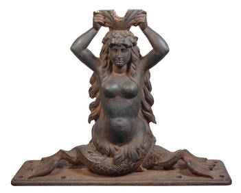
CAST IRON SHIP'S WHEEL BRACKET HELM IN THE FORM OF A MERMAID Last Quarter of the 19th/First QuarterEldred's4.7(419)See Sold PriceFeb 27, 2024
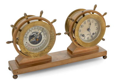
CHELSEA SHIP'S WHEEL BELL CLOCK AND BAROMETER SET Circa 1930-1950 Total height 8.75". Width 14".Eldred's4.7(419)See Sold PriceFeb 28, 2024
Vintage Weathermaster Wood Ship Wheel BarometerThe Benefit Shop Foundation Inc.4.3(2.9k)See Sold PriceFeb 28, 2024
Vintage German Time & Tide Co Nautical Chronometer And Tide ClockAkiba Galleries4.7(1.8k)See Sold PriceFeb 29, 2024
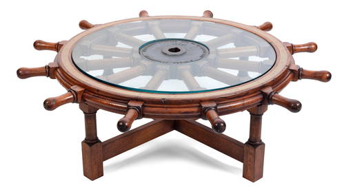
SHIPíS WHEEL MOUNTED AS A LOW TABLE Late 19th Century Wheel diameter 54.5". Height as tableEldred's4.7(419)See Sold PriceFeb 28, 2024
Vintage German Brass & Wood Ships Wheel BarometerLangston Auction Gallery4.7(508)See Sold PriceFeb 28, 2024
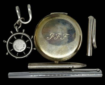
Lot of Assorted Tiffany Mostly Sterling Items.Direct Auction Galleries 4.7(337)See Sold PriceFeb 24, 2024
Four Fraternal Order Silver Badges/MedalsBroken Arch Auction Gallery NCFL#93994.6(300)See Sold PriceMar 04, 2024
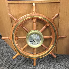
Vintage Chelsea Brass Clock In Wood Ship\'s Wheel 30"Andrew's Coin & Jewelry4.5(209)See Sold PriceMar 07, 2024
1977 Heilemans Special Export Ships Wheel Light-Up Advertising Beer SignMatthew Bullock Auctioneers4.7(1.8k)See Sold PriceMar 17, 2024
12" Premium Wooden Ship Steering Wheel Clock with Antique Copper FinishWeatherham Estate Treasures3.9(159)See Sold PriceMar 14, 2024
SoldBlaeu. 4 Maps On 2 Sheets. Amst: Blaeu, [c1630].Blaeu. 4 Maps On 2 Sheets. Amst: Blaeu, [c1630]. Copperplate engraved maps, each about 15 x 20 inches, very good in outline color with French text verso. ++ Carte du Bourdelois, du Pais de Medoc, et dSee Sold Price
Blaeu Map of North AmericaAmerica Nova Tabula. Willem Blaeu (1571-1638). Engraved Map with original hand color. Amsterdam, 1642. State 4. 19 1/2 x 23 1/4 inches sheet. Blaeu’s map of America is one of the most sought after mSee Sold Price
Blaeu Map of New EnglandBLAEU, Willem (1571-1638).Nova Belgica et Anglia Nova.Engraved map with original hand color in outline.Amsterdam, 1622 (1635 or later).19 1/4" x 23 1/2" sheet.This important map was one of the most atSee Sold Price
Blaeu Map of GuianaBlaeu, Willem (1571-1638). Guiana sive Amazonum Regio. Engraved map with original hand color. Amsterdam, c. 1640. 18 1/2” x 22 3/4” sheet. Nice map extending from the Isla Margarita in the northweSee Sold Price
SoldBlaeu Map of AmericaBLAEU, Willem (1571-1638).Americae Nova Tabula.Engraved map with original hand color.Amsterdam, 1642 (State 4).19 1/2" x 23 1/4" sheet.Classic Baroque map of the Americas by the most successful commerSee Sold Price
Joan Blaeu Engraved Map from the Atlas of Scotland - Ilse of BootBLAEU, Joan (1596-1673). Buthe Insula Vulgo the Yle of Boot. Engraved map with original hand color. Amsterdam: Joan Blaeu, 1654-1662. [Dutch Text on verso]. 20 1/4" x 24 1/2" sheet. In 1654 Joan BlaeuSee Sold Price
Joan Blaeu Engraved Map from the Atlas of Scotland - Region of Eskdale in DumfriesshireBLAEU, Joan (1596-1673). Evia et Escia, Scotis eusdall et Eskdail. Engraved map with original hand color. Amsterdam: Joan Blaeu, 1654-1662. [Dutch Text on verso]. 20 1/4" x 24 1/2" sheet. In 1654 JoanSee Sold Price
Joan Blaeu Engraved Map from the Atlas of Scotland - Kintyre and the Isle of GighaBLAEU, Joan (1596-1673). Cantyra Chersonesus / Cantyr a Demie-yland. Engraved map with original hand color. Amsterdam: Joan Blaeu, 1654-1662. [Dutch Text on verso]. 20 1/4" x 24 1/2" sheet. Map of KinSee Sold Price
Joan Blaeu Engraved Map from the Atlas of Scotland - SoutherlandiaBLAEU, Joan (1596-1673). Southerlandia. [Southerland, Scotland]. Engraved map with original hand color. Amsterdam: Joan Blaeu, 1654-1662. [Dutch Text on verso]. 20 1/4" x 24 1/2" sheet. In 1654 Joan BSee Sold Price
Joan Blaeu Engraved Map from the Atlas of Scotland - Stirling County, ScotlandBLAEU, Joan (1596-1673). Sterlinensis Praefectura / Sterlin-Shyr. Engraved map with original hand color. Amsterdam: Joan Blaeu, 1654-1662. [Dutch Text on verso]. 20 1/4" x 24 1/2" sheet. In 1654 JoanSee Sold Price
Joan Blaeu Engraved Map from the Atlas of Scotland - Lidalia vel Lidisdalia Regio, LidisdailBLAEU, Joan (1596-1673). Lidalia vel Lidisdalia Regio, Lidisdail. Engraved map with original hand color. Amsterdam: Joan Blaeu, 1654-1662. [Dutch Text on verso]. 20 1/4" x 24 1/2" sheet. This beautifuSee Sold Price
SoldWillem Blaeu - "Palatinus ad Rhenum"18th/19th century map of Germany titled, "Palatinus ad Rhenum". Inscribed in the plate, "Guiljelmum Blaeu". [Image: 16" x 19 1/2" on larger sheet; Frame: 21 1/2" x 25 1/4"]. Toning, severe water stainSee Sold Price
SoldBlaeu Engraved Map of AfricaAfricae Nova Descriptio. Willem Janszoon Blaeu (1571 - 1638). Engraved map with original hand color in part. Amsterdam, c. 1642-1663. 19 1/2 x 23 inches sheet, 32 1/2 x 28 3/4 inches framed.See Sold Price
SoldBlaeu World MapBlaeu, Willem (1571-1638). Nova Totius Terrarum Orbis Geographica Ac Hydrographica Tabula. Engraved map with original hand color. Amsterdam: c. 1617 or later (4th State). 19 3/4" x 23 3/4" sheet, 31 1See Sold Price
Spain.- Castile.- Blaeu (Willem Jansz.) UtriusqueSpain.- Castile.- Blaeu (Willem Jansz.) Utriusque Castiliae nova descriptio, engraved map with hand-colouring, platemark 415 x 500 mm. (16 1/4 x 19 3/4 in), sheet 495 x 595 mm. (19 1/2 x 23 1/2 in), FSee Sold Price
SoldAsia noviter delineataWillem Janszoon Blaeu (1571-1638). Amsterdam, 1621-30. Engraved map with original hand color in part. 18 x 23 1/2 inches sheet. Blaeu's map is one of the most famous decorative maps of Asia.This map sSee Sold Price
Blaeu Map of ChiliChili. Willem Janszoon Blaeu (1571-1638). Engraved map with original hand color. Amsterdam: Blaeu, c. 1650. 20 x 23 1/2 inches sheet. Willem Blaeu’s very decorative map of Chile features two large aSee Sold Price
Soldca 1634 Willem Blaeu map of Sabaudia Ducatus & Savoye 2ca 1634 Willem Blaeu map of Sabaudia Ducatus & Savoye 2 sheets 18” x 22.5” water stainsSee Sold Price
Sold1654 Blaeu “Vistus Insula Vulgo Viist” 2 sheet map of1654 Blaeu “Vistus Insula Vulgo Viist” 2 sheet map of the northernmost part of Scotland, h/c vignette w/ a fisherman & Gods of the Sea, 20” x 24 1/2”See Sold Price
SoldBlaeu Map of CaribbeanBLAEU, Willem (1571-1638). Insulae Americanae in Oceano Septentrionali cum Terris Adiacentibus. Engraved map with hand color. Amsterdam: c. 1635. 18 1/2" x 23 1/3" sheet. Nice example of Blaeu's chartSee Sold Price
SoldMaps (Ca. 1800). Lemovicum... Lymosin. Limaniae[FRANCE]. Blaeu. Amst: 17th cent. 2 engraved maps on 1 double-page sheet. 14 13/16 x 19 7/8. Some light areas of old waterstain, later coloring to 3 cartouches now washed out unevenly, contemporary coSee Sold Price
SoldBlaeu Map of BrazilMaritima Brasiliae Universa. Joan Blaeu (1596-1673). Engraved map with original color in part. Amsterdam: Blaeu, 1647. 21 x 24 1/2 inches sheet, 32 1/2 x 36 inches framed. This separately issued and rSee Sold Price
SoldBlaeu, Map of IcelandTabula Islandiae Auctore Georgio Carolo Flandro. Willem Blaeu (1571-1638). Engraved map with original hand color in full. Amsterdam, 1634. 17 x 21 1/2 inches sheet. This handsome map of Iceland was baSee Sold Price
SoldATTRIBUTED TO WILLEN BLAEU 2 ENGRAVED MAPSATTRIBUTED TO WILLEN BLAEU, 2 HAND COLORED ENGRAVED MAPS, "NAVA BELGICA" & "MAPPA AESTIVARUM", 15 1/4" X 19 3/4" & 16" X 21" DATES OF PRINTING ARE UNKNOWN; FRAMED. ARNOLD KLEIN FRAMING LABEL.See Sold Price
ABRAHAM ORTELIUS (1527-1598) MAP OF ROMAN GAUL (FRANCE)Thomaston Place Auction Galleries4.4(393)See Sold PriceFeb 24, 2024
WILLEM JANSZOON BLAEU (NETHERLANDS, 1571-1638) MAP OF UMBRIAThomaston Place Auction Galleries4.4(393)See Sold PriceFeb 24, 2024
Rembrandt van Rijn. Beggar with a Wooden Leg (c.1630). New Hollstein 49, III/IV Fairly thick, stiff,Tremont Auctions4.5(297)See Sold PriceFeb 25, 2024
Burmese Pali Canon Buddha Theravada Prayer Boards on Bamboo ManuscriptDana J. Tharp Auctions4.7(271)See Sold PriceFeb 24, 2024
Willem Blaeu, Etc. 17th C. Antiquarian Maps, 2Auctions at Showplace4.6(740)See Sold PriceMar 17, 2024
[BUSINESS]. Travel Guide of Negro Hotels and Guest Houses. Published by Afro-American Newspapers ofFreeman's | Hindman4.4(1.6k)See Sold PriceFeb 27, 2024
Hand Colored Engraved Map of Europe, Jean Baptiste Bourguignon Anville 1754Global Auctions Company4.3(36)See Sold PriceMar 03, 2024
1982 Takatoku Galactic Gale Baxinger DX Robot MIBBruneau & Co. Auctioneers4.5(491)See Sold PriceFeb 24, 2024
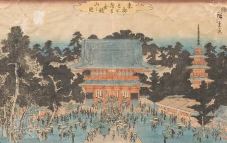
Utagawa Hiroshige, "Kinryuzan Temple in Asakusa"Old Kinderhook Auction Company4.6(217)See Sold PriceMar 05, 2024
[Constructivism]. The general plan of reconstruction of Moscow. - Moscow: Moscow Worker, 1936. -ARTMAXIMUM4.3(4)See Sold PriceMar 14, 2024
American Flyer Prewar narrow gauge steam freight setToystrainsandotheroldstuff LLC4.8(444)See Sold PriceMar 02, 2024
![Blaeu. 4 Maps On 2 Sheets. Amst: Blaeu, [c1630]. First Image](https://p1.liveauctioneers.com/179/2417/1045235_1_x.jpg?height=282&quality=95&width=282)
![Blaeu. 4 Maps On 2 Sheets. Amst: Blaeu, [c1630]. First Image](https://p1.liveauctioneers.com/179/2417/1045235_1_x.jpg?height=282&quality=1&width=282)


![Blaeu. 4 Maps On 2 Sheets. Amst: Blaeu, [c1630]. (1 of 2)](https://p1.liveauctioneers.com/179/2417/1045235_1_x.jpg?height=282&quality=70)


![[BUSINESS]. Travel Guide of Negro Hotels and Guest Houses. Published by Afro-American Newspapers of (1 of 4)](https://p1.liveauctioneers.com/197/319238/171467937_1_x.jpg?height=282&quality=70&version=1707520367)


![[Constructivism]. The general plan of reconstruction of Moscow. - Moscow: Moscow Worker, 1936. - (1 of 6)](https://p1.liveauctioneers.com/6171/320219/172084257_1_x.jpg?height=282&quality=70&version=1708525949)


