Popular Searches

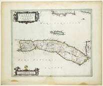
Joan Blaeu Engraved Map from the Atlas of Scotland - Kintyre and the Isle of Gigha
Related Maps & Atlases
More Items in Maps & Atlases


Recommended Transportation & Travel Collectibles


Item Details
Description
BLAEU, Joan (1596-1673).
Cantyra Chersonesus / Cantyr a Demie-yland.
Engraved map with original hand color.
Amsterdam: Joan Blaeu, 1654-1662. [Dutch Text on verso].
20 1/4" x 24 1/2" sheet.
Map of Kintyre and the Isle of Gigha, situated off Glasgow and off the western coast of Isle of Arran.
In 1654 Joan Blaeu applied for a privilege to publish maps and descriptions of Scotland and received privileges from the State of Holland and West Friesland, Oliver Cromwell, and Holy Roman Emperor Ferdinand III. His source was a series of manuscript maps by Timothy Pont from his survey of 1596 to about 1600 with information added by Robert Gordon.
Ref.: The Early Maps of Scotland to 1850. 3rd. ed. By D. G. Moir and a Committee of the Royal Scottish Geographical Society. (Edinburgh, 1973) and Peter van der Krogt, Koeman's Atlantis Neerlandici. New Edition: II, 266-294.
Buyer's Premium
- 25%
Joan Blaeu Engraved Map from the Atlas of Scotland - Kintyre and the Isle of Gigha
Shipping & Pickup Options
Item located in New York, NY, USPayment


![Joan Blaeu Engraved Map from the Atlas of Scotland - Isle of Arran: BLAEU, Joan (1596-1673). Arania Insula in Aestuario Glottae / The Yse of Arren in the Fyrth of Clyd. Engraved map with original hand color. Amsterdam: Joan Blaeu, 1654-1662. [Dutch Text on verso]. 20](https://p1.liveauctioneers.com/1968/336799/182230480_1_x.jpg?height=310&quality=70&version=1721234456)

![Joan Blaeu Engraved Map from the Atlas of Scotland - Ilse of Boot: BLAEU, Joan (1596-1673). Buthe Insula Vulgo the Yle of Boot. Engraved map with original hand color. Amsterdam: Joan Blaeu, 1654-1662. [Dutch Text on verso]. 20 1/4" x 24 1/2" sheet. In 1654 Joan Blaeu](https://p1.liveauctioneers.com/1968/336799/182230486_1_x.jpg?height=310&quality=70&version=1721234456)

![Joan Blaeu Engraved Map from the Atlas of Scotland - Lancashire: BLAEU, Joan (1596-1673). Lancastria Palatinatus Anglis Lancaster et Lancas Shire. Engraved map with original hand color. Amsterdam: Joan Blaeu, 1654-1662. [Dutch Text on verso]. 20" x 24" sheet. In 16](https://p1.liveauctioneers.com/1968/336799/182230479_1_x.jpg?height=310&quality=70&version=1721234456)
![Joan Blaeu Engraved Map from the Atlas of Scotland - Counties of Montgomery and Merioneth: BLAEU, Joan (1596-1673). Montgomeria Comitatus et Comitatus Meruinia. Engraved map with original hand color. Amsterdam: Joan Blaeu, 1654-1662. [Dutch Text on verso]. 20" x 24" sheet. Showing the Count](https://p1.liveauctioneers.com/1968/336799/182230467_1_x.jpg?height=310&quality=70&version=1721234456)
![Joan Blaeu Engraved Map from the Atlas of Scotland - Counties of Bedford and Buckingham: BLAEU, Joan (1596-1673). Bedfordiensis Comitatus Anglis Bedford Shire [WITH] Buckinghamiensis Comitatus Anglis Buckingham Shire. Engraved map with original hand color. Amsterdam: Joan Blaeu, 1654-1662](https://p1.liveauctioneers.com/1968/336799/182230463_1_x.jpg?height=310&quality=70&version=1721234456)
![Joan Blaeu Engraved Map from the Atlas of Scotland - Annandale: BLAEU, Joan (1596-1673). Annandiae Praefectura Vulgo The Stewartie of Annandail. Engraved map with original hand color. Amsterdam: Joan Blaeu, 1654-1662. [Dutch Text on verso]. 20 1/4" x 24 3/8" sheet](https://p1.liveauctioneers.com/1968/336799/182230495_1_x.jpg?height=310&quality=70&version=1721234456)

![Joan Blaeu Engraved Map from the Atlas of Scotland - Region of Eskdale in Dumfriesshire: BLAEU, Joan (1596-1673). Evia et Escia, Scotis eusdall et Eskdail. Engraved map with original hand color. Amsterdam: Joan Blaeu, 1654-1662. [Dutch Text on verso]. 20 1/4" x 24 1/2" sheet. In 1654 Joan](https://p1.liveauctioneers.com/1968/336799/182230492_1_x.jpg?height=310&quality=70&version=1721234456)
![Joan Blaeu Engraved Map from the Atlas of Scotland - Caithness region NE Scotland: BLAEU, Joan (1596-1673). Cathenesia / Caithness. Engraved map with original hand color. Amsterdam: Joan Blaeu, 1654-1662. [Dutch Text on verso]. 20 1/8" x 24 5/8" sheet. In 1654 Joan](https://p1.liveauctioneers.com/1968/336799/182230484_1_x.jpg?height=310&quality=70&version=1721234456)

![Joan Blaeu Engraved Map from the Atlas of Scotland - Dorset: BLAEU, Joan (1596-1673). Comitatus Dorcestria, sive Dorsettia Vulgo Anglice Dorset Shire. Engraved map with original hand color. Amsterdam: Joan Blaeu, 1654-1662. [Dutch Text on verso]. 20" x 24" shee](https://p1.liveauctioneers.com/1968/336799/182230478_1_x.jpg?height=310&quality=70&version=1721234456)
![Joan Blaeu Engraved Map from the Atlas of Scotland - Shropshire: BLAEU, Joan (1596-1673). Comitatus Salopiensis Anglice Shrop Shire. Engraved map with original hand color. Amsterdam: Joan Blaeu, 1654-1662. [Dutch Text on verso]. 20" x 24" sheet. In 1654 Joan Blaeu](https://p1.liveauctioneers.com/1968/336799/182230476_1_x.jpg?height=310&quality=70&version=1721234456)
![Joan Blaeu Engraved Map from the Atlas of Scotland - Rutland Shire: BLAEU, Joan (1596-1673). Rutlandia Comitatus / Rutland Shire. Engraved map with original hand color. Amsterdam: Joan Blaeu, 1654-1662. [Dutch Text on verso]. 20" x 24 1/4" sheet. In 1654 Joan Blaeu ap](https://p1.liveauctioneers.com/1968/336799/182230474_1_x.jpg?height=310&quality=70&version=1721234456)


![De Vaugondy map of China: Heading: (China) Author: Robert de Vaugondy, Gilles and Didier Title: L'Empire de la Chine dressé d'après les Cartes de l'Atlas Chinois Place Published: [Paris] Publisher: Date Published: 1](https://p1.liveauctioneers.com/642/319971/171838574_1_x.jpg?height=310&quality=70&version=1708735487)


