SoldWall Map of N.Y. State Counties. "Concise, ReadyWall Map of N.Y. State Counties. "Concise, Ready Reference. Counties, County Seats, Cities, Post Offices, Rail Stations, Villages etc... Color Good, Condition Poor. 40"h x 50"wSee Sold Price
Sold1863 Cortland Chenango County NY WALL MAP CuylerTitle: Chenango and Cortland Counties, New York Draughtsman/Cartographer/Surveyor: S. N. & F. W. Beers, A. & C. S. Warner, and B. Nichols Publisher: A. Pomeroy & S. W. Treat (Philadelphia) Printing YSee Sold Price
Sold1855 Jefferson County, NY Wall MapJ.B. Shields Publisher. 55" x 54". In poor condition with staining and roughness along edges. Perimeter shows important buildings around the county at that time. From Col. Elisha Camp's Federal Home iSee Sold Price
Sold1852 Canandaigua County NY WALL MAP Geneva NaplesTitle: Ontario County, New York Draughtsman/Cartographer/Surveyor: H. F. Walling Publisher: John E. Gillette Printing Year: 1852 Dimensions: 48 inches x 41 inches Condition/Details: ThisSee Sold Price
Sold1856 Clinton County NY WALL MAP Plattsburgh ChazyTitle: Clinton County, New York Draughtsman/Cartographer/Surveyor: A. Ligowsky Publisher: O. J. Lamb (Philadelphia) Printing Year: 1856 Dimensions: 50 inches x 56 inches Condition/Details:</See Sold Price
Sold1853 Westchester County NY WALL MAP Mount VernonTitle: Map of the Southern Part of West-Chester County, New York Draughtsman/Cartographer/Surveyor: R. F. O. Connor Publisher: M. Dripps (New York) Printing Year: 1853 Dimensions: 51 inches x 44See Sold Price
Sold1858 Oneida County NY WALL MAP Utica Rome BeersTitle: Oneida County, New York Draughtsman/Cartographer/Surveyor: J. H. French, S. N. & F. W. Beers, and D. J. Lake Publisher: John E. Gillette (Philadelphia) Printing Year: 1858 Dimensions: 64 iSee Sold Price
Sold1855 Jefferson County NY WALL MAP Thousand IslandTitle: Jefferson County, New York Draughtsman/Cartographer/Surveyor: Morris Levey Publisher: J. B. Shields Printing Year: 1855 Dimensions: 54 inches x 55 inches Condition/Details: This lSee Sold Price
Soldc1850 Dutchess County NY WALL MAP PoughkeepsieTitle: Dutchess County, New York Draughtsman/Cartographer/Surveyor: J. C. Sidney Publisher: John E. Gillett Printing Year: c1850 Dimensions: 42 inches x 58 inches Condition/Details: ThisSee Sold Price
Sold1865 Yates County NY WALL MAP Penn Yan DundeeTitle: Yates County, New York Draughtsman/Cartographer/Surveyor: S. N. & D. G. Beers assisted by A. B. Prindle and H. A. Hawley Publisher: Stone & Steward (Philadelphia) Printing Year: 1865 DimensionSee Sold Price
Sold1856 Greene County NY WALL MAP Coxsackie CatskillTitle: Greene County, New York Draughtsman/Cartographer/Surveyor: Samuel Geil Publisher: E. A. Balch (Philadelphia) Printing Year: 1856 Dimensions: 55 inches x 39 inches Condition/Details:</See Sold Price
SoldDutchess County NY wall map published by John E.Dutchess County NY wall map published by John E. Gillette, Philadelphia 1858 - some fraying of paper near top, otherwise good condition.See Sold Price
SoldAntique 1858 Wall Map,Dutchess County,NY Rhinebeck,EtcAntique 1858 Wall Map,Dutchess County,NY Rhinebeck,Etc. This Large detailed antique map of Dutchess county New York is dated 1858. This large map has lots of great little details including drawings anSee Sold Price
Canvas wall map of Dutchess County NY, published byCanvas wall map of Dutchess County NY, published by John E. Gillette, Philadelphia, 1858. Losses to lithograph paper mostly in the top right corner. See photos for more details. Size 58" x 62".See Sold Price
SoldLarge frame wall map of Delaware County NY dated 1Large frame wall map of Delaware County NY dated 1856, published by Collins G. Keeney, Phila. 56" x 56"See Sold Price
Two 19th C. Hanging Wall Maps, NY & PennsylvaniaBeers Lake and Beers wall map of Columbia County, NY, Philadelphia,1858, and Smith, Gallup and Co. wall map of Northampton County, PA, Philadelphia, 1860. Each in fair to poor condition with staining,See Sold Price
SoldFly Fishing Archive incl. Maps & BooksFly fishing archive belonging to Jordan Hoolick who worked for Angler Publications. Archive includes: 4 NY state county fishing guide fold-out maps published by Angler Publications along with the origSee Sold Price
SoldA New Map of our Country,c 1854.[United States]. A New Map Of Our Country, Prospective. And Present Compiled from Government Surveys and other Reliable Sources. Wall map. NY: Gaston & Johnson, 1854. 50 x 57 3/4 inches, excluding elaSee Sold Price
Sold1829 David Burr Map of the County of Essex, NY h/c wall1829 David Burr Map of the County of Essex, NY h/c wall map- plate size 23” x 19”See Sold Price
SoldWall Map by Gaston & Johnson, Our Country, Present andWall Map by Gaston & Johnson, Our Country, Present and Prospective(New York, 1856), a late antebellum map of the United States showing counties and minor cities. Linen backing with wooden roller. 57.5See Sold Price
SoldWall map of Sacramento County 1924Title: Map of the county of Sacramento, California. Showing cities, towns, subdivisions, county roads, state and county highways, railroads, political townships, school districts, reclamation districtSee Sold Price
Collection of 9 Everts New Century Atlas maps 1912 for Collection of 9 Everts New Century Atlas maps 1912 for various counties in NY state including Schenectady, Fulton, Ontario, Clinton, Lewis, Jefferson, Orleans, Genesee and Tompkins Counties.See Sold Price
SoldWALL MAP OF THE STATE OF MAINE.Circa 1862, Portland, Maine. J. Chace, Jr. & Co. Publishers. U.S. Coast Survey Table by H.F. Walling. A large map showing the state of Maine. The towns and counties, maps of some small towns tipped inSee Sold Price
SoldCram: Antique Ohio Railroad Retractable Wall Map, 1901Title/Content of Map: 1901 Cram's Ohio Railroad Retractable Wall Map -- Cram's Superior Map of Ohio Accompanied by a Concise and Original Ready Reference Index showing all Railroad Systems and ExpressSee Sold Price
1892 Adams and Bowles New Road Map of the State of New YorkJM Hobby Supply and Railroad Artifact Auctions4.4(127)See Sold PriceFeb 24, 2024
Crams Railroad Map of New York-1881JM Hobby Supply and Railroad Artifact Auctions4.4(127)See Sold PriceFeb 24, 2024
Rand McNally Railroad Map of Arizona-1909JM Hobby Supply and Railroad Artifact Auctions4.4(127)See Sold PriceFeb 24, 2024
Rand McNally Railroad Map of Washington-1906JM Hobby Supply and Railroad Artifact Auctions4.4(127)See Sold PriceFeb 24, 2024
United States Map with American Flag 3-D Wall Mount PaintingWeatherham Estate Treasures3.9(159)See Sold PriceFeb 29, 2024
Vintage County Map Of NY State Plate EngravingThe Benefit Shop Foundation Inc.4.3(2.9k)See Sold PriceFeb 28, 2024
Rand McNally & Co's New Ideal State and County Survey and Atlas 1911North American Artifact Auctions4.7(198)See Sold PriceApr 20, 2024
[CHICAGO]. Rare Pre-Fire Illinois Map: “Blanchard’s Map of ...Potter & Potter Auctions4.6(545)See Sold PriceMar 07, 2024
1905 20th Century Atlas of Boone County IllinoisMatthew Bullock Auctioneers4.7(1.8k)See Sold PriceFeb 24, 2024
3 Vintage The World Lithographs, By JanssonThe Benefit Shop Foundation Inc.4.3(2.9k)See Sold PriceMar 13, 2024
Aluminr Bespoke style Copper Designed Wall PlaqueRoyal Treasures Warehouse LLC3.8(114)See Sold PriceFeb 25, 2024
Map of Yorktown - York County in Virginia - United StatesProverde Auctions4.3(3)See Sold PriceFeb 28, 2024
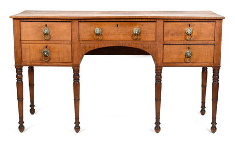
FEDERAL HUDSON VALLEY NY FIGURED MAPLE SIDEBOARD.William Smith Auctions4.6(147)See Sold PriceMar 06, 2024
Vintage 1920s Rand McNally Auto Trails MapThe Benefit Shop Foundation Inc.4.3(2.9k)See Sold PriceMar 20, 2024


![[CHICAGO]. Rare Pre-Fire Illinois Map: “Blanchard’s Map of ... (1 of 2)](https://p1.liveauctioneers.com/928/318880/171361260_1_x.jpg?height=282&quality=70&version=1707501302)