ATLAS of ANTIENT GEOGRAPHY by SAMUEL BUTLER 1843John McInnis Auctioneers,LLC4.6(502)See Sold PriceFeb 24, 2024
18TH C. ANTIQUE MAP: FRENCH & INDIAN WAR, FRAMEDThomaston Place Auction Galleries4.4(386)See Sold PriceFeb 24, 2024
Rand McNally Railroad Map Cabinet w/ 21 Railroad MapsRail & Road Auctions4.6(165)See Sold PriceMar 08, 2024
Keith Haring - Ink on New York Map, Best Buddies, Inscribed, Signed, and DatedSapphire Auction Gallery4(67)See Sold PriceMar 02, 2024
LATE 17TH C. FRENCH MAP OF THE NEW WORLD BY ALEXIS-HUBERT JAILLOT (1632-1712)Thomaston Place Auction Galleries4.4(386)See Sold PriceFeb 24, 2024
Central Railroad of New Jersey Map of Sandy Hook Route-ca. 1903JM Hobby Supply and Railroad Artifact Auctions4.4(126)See Sold PriceFeb 24, 2024
Lot of Six Mixed Atlas Box Cars-HO Scale-New in BoxJM Hobby Supply and Railroad Artifact Auctions4.4(126)See Sold PriceFeb 25, 2024
Rand McNally/Santa Fe Railroad Map of Iowa-1912JM Hobby Supply and Railroad Artifact Auctions4.4(126)See Sold PriceFeb 24, 2024
NICOLAES VISSCHER (NETHERLANDS, 1618-1709) MAP OF THE NEW WORLDThomaston Place Auction Galleries4.4(386)See Sold PriceFeb 24, 2024
17TH C. WORLD MAP BY NICOLAES VISSCHER (NETHERLANDS, 1618-1709)Thomaston Place Auction Galleries4.4(386)See Sold PriceFeb 24, 2024
Lot of Six Mixed Atlas Cabooses-HO Scale-New in BoxJM Hobby Supply and Railroad Artifact Auctions4.4(126)See Sold PriceFeb 25, 2024
SoldCHARLESTON MAP BIRDS EYE VIEW 1872Fine birdseye view of South Carolina, published in Baltimore by C. Drie C. 1872. This map is the artists impression of how the city of Charleston was in 1872. This birds eye view of the city is lookinSee Sold Price
Sold19th century map of Charleston,"Birds Eye View of the City of Charleston, South Carolina, 1872, Drawn and Published by C. Drie" (Camille Drie, dates unknown), streets and buildings with reference key at bottom, color lithograph, 23See Sold Price
Soldc 1877 MAP BIRDS EYE VIEW OF BOSTON LITHOFramed Tinted Lithograph delineated by John Bachmann, published by L. Prang & Co., Boston, 1877. In frame measures 22 50x18x1" Weight is 5 pds. PROVENANCE: A Private Charleston SC Estate.See Sold Price
OLD 1872 PRINT BIRDs EYE VIEW MAP of PHILADELPHIAOLD 1872 PRINT BIRDs EYE VIEW MAP of PHILADELPHIA HARPERs WEEKLY, Theodore Davis OLD 1872 PRINT BIRDs EYE VIEW MAP of PHILADELPHIA HARPERs WEEKLY, Theodore Davis Description 1872 Historical Antique PrSee Sold Price
OLD 1872 PRINT BIRDs EYE VIEW MAP of PHILADELPHIAOLD 1872 PRINT BIRDs EYE VIEW MAP of PHILADELPHIA HARPERs WEEKLY, Theodore Davis OLD 1872 PRINT BIRDs EYE VIEW MAP of PHILADELPHIA HARPERs WEEKLY, Theodore Davis Description 1872 Historical Antique PrSee Sold Price
SoldRevolutionary map, Charleston Harbor,"A Birds Eye View from part of Mount Pleasant…" by William Faden (1750-1836), London, 1776, showing panoramic view of islands in Charleston Harbor including fortifications, encampments, and a legendSee Sold Price
Map and Prints of the Great Boston Fire, 1872Map: 1872 Map and Prints of the Great Boston Fire Maker: Harper's Weekly Publishing Date: 11 30 1872 New York Size: 13.5 x 20.5 in. (map) A large, detailed two page bird's eye view map of Boston showiSee Sold Price
C.N. Drie. Bird’s Eye View of the City of Charleston,Art Print on Canvas - C.N. Drie. Bird’s Eye View of the City of Charleston, South Carolina, 1872See Sold Price
C.N. Drie. Bird’s Eye View of the City of Charleston,C.N. Drie. Print on Canvas. Bird’s Eye View of the City of Charleston, South Carolina, 1872. Image Size: 16 x 24 Size Incuding Trim: 20 x 28See Sold Price
Sold[CHICAGO FIRE]. Bird’s-Eye View of Chicago[CHICAGO FIRE]. Bird’s-Eye View of Chicago Restored. The Lakeside Monthly Supplement. Chicago: J.J. Spalding, 1872. Engraving by Bond & Chandler (Chicago), from a photograph by Hall (350 x 1035See Sold Price
SoldA bird’s eye panoramic view of Plymouth, DevonPlymouth, supplement to the Illustrated London News September 14, 1872. Hand-colored engraving. London: Illustrated London News, 1872. 23 x 52 1/4 inches sheet. issued as a supplement to the IllustratSee Sold Price
SoldAN ANTIQUE MAP, "Bird's-eye View of the City ofAN ANTIQUE MAP, "Bird's-eye View of the City of Seattle, Puget Sound, Washington Territory," SAN FRANCISCO, 1878, color lithograph on paper, "Drawn by E.S. Glover, Portland, Oregon," "A.L. Bancroft &See Sold Price
SoldRare Topographic Civil War Map, Birds Eye ViewRare Topographic Civil War Map, Birds Eye View of Virginia, Maryland, Delaware and the District of Columbia 22 x 29.75 in. map, mounted on linen and attached to wooden hanging bar. The title The SeSee Sold Price
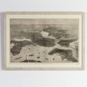
SoldMap, Birds Eye View, New York, Hammond, 1909This map is a chromolithograph depiction of a bird's eye view of New York City in 1909. It shows the development from Jamaica Bay up to Westchester County.See Sold Price
SoldMap: Bird's Eye View of Port of Kure, Japan"The Bird's Eye View of Port of Kure". Map. Dimensions: 22" H x 42" W; See Sold Price
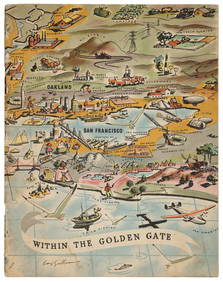
SoldMap & bird's-eye view of Alameda, California 1947Heading: (California - Alameda) Author: Title: Street Map of City of Alameda Place Published: Alameda, CA Publisher:Alameda Chamber of Commerce Date Published: 1947 Description:See Sold Price
Map & bird's-eye view of Alameda, California 1947Heading: (California - Alameda) Author: Title: Street Map of City of Alameda Place Published: Alameda, CA Publisher:Alameda Chamber of Commerce Date Published: 1947 Description:See Sold Price
SoldBird's-Eye-View of the Holy Land 1886Title/Content of Map: Bird's-Eye-View of the Holy Land 1886 Date Printed: 1886 Material/Medium: paper Size: approx. 14x11 inches The People's Family Atlas of the World. Publ. by W.H. Stewart, RochesteSee Sold Price
Birds-Eye View of the Holy Land 1909Title/Content of Map: Birds-Eye View of the Holy Land 1909 Date Printed: 1909 Material/Medium: paper Size: approx. 13x 10.5 inches Davis Illustrated Encyclopaedia of the World Reserve: $25.00 ShippingSee Sold Price
Vintage Birds-eye View of Casco Bay, 1950Map: Birds-eye View of Casco Bay, Portland, Maine and Surroundings Maker: Down-East Sportcraft Publication Date: 1950 Geographic Area: United States Body of Water: Casco Bay Condition: Good. NumerousSee Sold Price
Union News: Birdseye View of Boston Harbor, 1917Title/Content of Map: Birds Eye View of Boston Harbor in colors along the South Shore to Plymouth, Cape Cod Canal and Provincetown Showing all Steamboat Routes. Date Printed: 1917 Cartographer: Finn,See Sold Price
SoldCram: Antique Birds-Eye-View of the Holy Land, 1891Map: Birds-Eye-View of the Holy Land Date: 1891 From Cram's "Unrivaled Family Atlas of the World Indexed" Size: 14.5 x 11 inches George F. Cram (1842-1928) served in the U.S. Army during the AmericanSee Sold Price
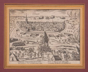
16TH C. BIRDSEYE VIEW OF SEIGE OF STEENWYCK, NETHERLANDS BY FRANS HOGENBERG (1535-1590)Thomaston Place Auction Galleries4.4(386)See Sold PriceFeb 24, 2024
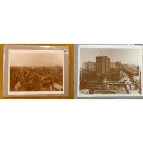
Pair of Early 1900's Atlanta Georgia Photo PrintsConnoisseur Auctions4(333)See Sold PriceFeb 24, 2024
Bird's Eye View of Boston Engraving by Illustrated London News 1872Passion For Antiques3.9(23)See Sold PriceFeb 25, 2024
Group of 15 Printed or Lithographed Items, including: litho...Potter & Potter Auctions4.6(539)See Sold PriceMar 07, 2024
Jorn Fox Impressionist Signed Original Oil on CanvasMichael's Gallery4.6(89)See Sold PriceFeb 24, 2024
Jennifer Neurnan "Winter ..." Silver Gelatin PrintAuctions at Showplace4.5(726)See Sold PriceApr 16, 2024
Jorn Fox Impressionist Signed Original Oil on CanvasMichael's Gallery4.6(89)See Sold PriceMar 02, 2024


![[CHICAGO FIRE]. Bird’s-Eye View of Chicago (1 of 3)](https://p1.liveauctioneers.com/928/212515/108628808_1_x.jpg?height=282&quality=70&version=1627420959)


![[Map] Bird's-Eye View of MD, DC, & VA (1 of 4)](https://p1.liveauctioneers.com/523/84219/43476528_1_x.jpg?height=282&quality=70&version=1453240168)
![[Map] Bird's-Eye View of VA, MD, DE & DC (1 of 5)](https://p1.liveauctioneers.com/523/84219/43476533_1_x.jpg?height=282&quality=70&version=1453240168)