ATLAS of ANTIENT GEOGRAPHY by SAMUEL BUTLER 1843John McInnis Auctioneers,LLC4.6(502)See Sold PriceFeb 24, 2024
18TH C. ANTIQUE MAP: FRENCH & INDIAN WAR, FRAMEDThomaston Place Auction Galleries4.4(386)See Sold PriceFeb 24, 2024
Rand McNally Railroad Map Cabinet w/ 21 Railroad MapsRail & Road Auctions4.6(165)See Sold PriceMar 08, 2024
Keith Haring - Ink on New York Map, Best Buddies, Inscribed, Signed, and DatedSapphire Auction Gallery4(67)See Sold PriceMar 02, 2024
LATE 17TH C. FRENCH MAP OF THE NEW WORLD BY ALEXIS-HUBERT JAILLOT (1632-1712)Thomaston Place Auction Galleries4.4(386)See Sold PriceFeb 24, 2024
Central Railroad of New Jersey Map of Sandy Hook Route-ca. 1903JM Hobby Supply and Railroad Artifact Auctions4.4(126)See Sold PriceFeb 24, 2024
Lot of Six Mixed Atlas Box Cars-HO Scale-New in BoxJM Hobby Supply and Railroad Artifact Auctions4.4(126)See Sold PriceFeb 25, 2024
Rand McNally/Santa Fe Railroad Map of Iowa-1912JM Hobby Supply and Railroad Artifact Auctions4.4(126)See Sold PriceFeb 24, 2024
NICOLAES VISSCHER (NETHERLANDS, 1618-1709) MAP OF THE NEW WORLDThomaston Place Auction Galleries4.4(386)See Sold PriceFeb 24, 2024
17TH C. WORLD MAP BY NICOLAES VISSCHER (NETHERLANDS, 1618-1709)Thomaston Place Auction Galleries4.4(386)See Sold PriceFeb 24, 2024
Lot of Six Mixed Atlas Cabooses-HO Scale-New in BoxJM Hobby Supply and Railroad Artifact Auctions4.4(126)See Sold PriceFeb 25, 2024
Niederlande: Provinces-Unies des Pays-BasNiederlande. Provinces-Unies des Pays-Bas avec leurs Acquisitions dans la Flandre, le Brabant, le Limbourg, et le Lyege ... Kupferstich mit großer, zeitgenöss. kolorierter allegorischer KartSee Sold Price
Provinces Unies Des Pays-BasTitle: Provinces Unies Des Pays-Bas Publication Date: 1750 Cartographer: ROBERT DE VAUGONDY, DIDIER Size: 5.75Height - 5.8Width Additional Information: Par le S. Robert de Vaugondy avec privilege du rSee Sold Price
Les Provinces-Unies des Pays-Bas. Netherlands. ROBERT DE VAUGONDY 1753 mapTITLE OF MAP (NOT PRINTED ON THE PAGE):'Les Provinces-Unies des Pays-Bas, que comprennent le Duché de Gueldre, les Comtés de Hollande, de Zelande, de Zutphen, les Seigneuries d'Utrecht, d'OuSee Sold Price
Les Provinces-Unies Des Pays-Bas,Title/Content of Map: Les Provinces-Unies Des Pays-Bas, Date: 1757 Cartographer: ROBERT DE VAUGONDY, GILLES (1686-1766) Publisher: LES AUTEURS ET BOUDET Size: 19Height - 23Width qui comprennent le DucSee Sold Price
SoldL'Isle Provinces Unies des Pays BasL'Isle (Guillaume de) Carte des Provinces Unies des Pays Bas,Holland with large decorative title cartouche, engraved map with original outline hand-colouring, 480 x 620mm., central vertical foSee Sold Price
SoldProvinces Unies Des Pays-BasTitle/Content of Map: Provinces Unies Des Pays-Bas Date: 1750 Cartographer: ROBERT DE VAUGONDY, DIDIER Size: 5.75Height - 5.8Width Par le S. Robert de Vaugondy avec privilege du roi. 1750. Page 178 ofSee Sold Price
Provinces Unies Des Pays-BasPublication Date: 1750 Title: Provinces Unies Des Pays-Bas Cartographer: ROBERT DE VAUGONDY, DIDIER Height: 5.75 Width: 5.8 "Par le S. Robert de Vaugondy avec privilege du roi. 1750." Page 178 of a seSee Sold Price
Provinces Unies Des Pays-BasTitle/Content of Map: Provinces Unies Des Pays-Bas Date: 1750 Cartographer: ROBERT DE VAUGONDY, DIDIER Size: 5.75X5.8 "Par le S. Robert de Vaugondy avec privilege du roi. 1750." Please note that thisSee Sold Price
SoldGrp: 9 Maps of FranceGroup of nine maps of France and other parts of Northern Europe. Hand Colored Map of the Netherlands "Les Provinces Unies des Pays-Bas" 1672; Nicolas Sanson (1600-1667) Hand Colored Map of "Les Deux BSee Sold Price
SoldLot of Two Engraved and Colored MapsLot of two engraved and colored maps, "Provinces Unies Des Pays Bas", 17" h x 21 1/2" w (sight), "Map of Europe" dated 1853, 15 1/4" h x 19 3/4" w (sight), largest frame 22" h x 27" w. Provenance: FroSee Sold Price
Bonne: Antique Map of the Netherlands, 1780TITLE/CONTENT OF MAP: 'Carte De La Hollande prise en general Contenant Les Sept Provinces Unies des Pays Bas' A map of the Netherlands DATE PRINTED: 1780 IMAGE SIZE: Approx 23.0 x 34.5cm, 9 x 13.5 incSee Sold Price
Sold"Carte des Provinces Unies..." G.M. Cassini, map"Carte des Provinces Unies..." G.M. Cassini, map, 18th Century, "Carte des Provinces Unies des Pays Bas", Royal Academy of Sciences, Paris, 1702, with some hand coloring, 19.5" x 25" (sight), framed uSee Sold Price
SoldFRAMED MAP OF THE NETHERLANDS, AFTER GERALD VALKFramed hand colored map, after Gerald Valk (Dutch, 1652-1726), "Provinces-Unies des Pays-Bas, avec leurs Acquisitions dans la Fladre, le Brabant, et Limbourg et le Lyege", 18.25"h, 26"w, 24"h, 32"w, 7See Sold Price
SoldSanson-Jaillot, a hand colored map, “Provinces-UnSanson-Jaillot, a hand colored map, “Provinces-Unies des Pays Bas avec leur Acquisitions ... par le Sr Sanson, ... 1692.” , 23" x 36" sight sizeSee Sold Price
SoldCarte de la Hollandecontenant les Sept Provinces.TITLE/CONTENT OF MAP: 'Carte De La Hollande prise en general Contenant Les Sept Provinces Unies des Pays Bas' A map of the Netherlands Date: 1780 IMAGE SIZE: Approx 23.0 x 34.5cm, 9 x 13.5 inches (LarSee Sold Price
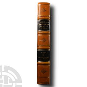
Sold[Jean LE CLERC ]- Explication historique des princ[Jean LE CLERC ]- Explication historique des principales médailles frapées [sic] pour servir à l'Histoire des Provinces-Unies des Pays-Bas [...]. Amsterdam, L'Honoré & Châtelain, 1723. In-folio,See Sold Price
Sold685 [Droit] Loi fondamentale des Provinces Unies des Pa[Droit] Loi fondamentale des Provinces Unies des Pays-Bas ou Constitution hollandaise. Bruxelles, Weissenbruch, s. d. Extrait des Gazettes de Leyde des 25, 29 Mars et 3 Avril 1814.See Sold Price
Map of United Provinces of the Netherlands. 1809.Print from steel engraving titled „Provinces unies des Pays Bas“.Author/compiler – M. Barthelemy.Engraved unknown.Notes: After restauration.From „Methode abregee et facile pour apprenre la geoSee Sold Price
Map of United Provinces of the Netherlands. 1809.Print from steel engraving titled „Provinces unies des Pays Bas“.Author/compiler – M. Barthelemy.Engraved unknown.Notes: After restauration.From „Methode abregee et facile pour apprenre la geoSee Sold Price
Sold[MAP] DELISLE, GUILLAUME Carte des Provinces Unie[MAP] DELISLE, GUILLAUME Carte des Provinces Unies des Pays Bas Engraved map, outlines colored by hand. 19 1/2 x 25 inches. Framed. Amsterdam: Jean Covens, n.d.See Sold Price
[HOLLAND] DE LA POINTE, F. La HollandeDE LA POINTE, F. La Hollande ou les provinces unies des Pays Bas. A Paris; XVIIImo Secolo 395x524; incisa in rame, a colori. Rara, mappa colorata del De La Pointe che raffigura l’Olanda e le ProvincSee Sold Price
Map of Europe, showing its Political Divisions by S. Augustus Mitchell 1869TITLE/CONTENT OF MAP: Les Sept Provinces Unies des Pays-Bas, ou la Hollande avec les Pays-Bas Autrichiens [The Seven United Provinces of the Netherlands or Holland, with the Austrian Netherlands] DATESee Sold Price
MAPS - Low Countries. De FerLow Countries. De Fer/Wyld, [Lot of 3] Les Provinces Apellees Pais Bas Connues sous les Noms de Flandre et de Hollande... [and] La Hollande ou les Provinces Unies des Pays Bas... [and] Map of the NethSee Sold Price
Le Clerc,(J.).Histoire des Provinces-Unies des Pays Bas... Bd. 3 (von 4). Amsterdam, Chatelain 1728. Fol. Mit gest. Front., gest. Titelvign. u. gest. Kopfvign. 12 Bl., 473 S. - ╔Angebunden:╗ ExplicationSee Sold Price
Numismatic Books - Miscellanea Numismatique 1872-1891TimeLine Auctions Ltd.4.5(183)See Sold PriceMar 09, 2024
[MAPS]. DUFOUR, Auguste-Henri (1795-1865). Bound Volume of ...Potter & Potter Auctions4.6(539)See Sold PriceMar 07, 2024
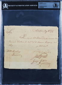
George Washington Signed 6x7.5 1787 Potomac Company Pay Order BAS SlabbedMynt Auctions4.6(680)See Sold PriceFeb 23, 2024
Duval - Pair: Map of Georgia & Map of Moscow, RussiaTrillium Antique Prints & Rare Books4.5(30)See Sold PriceFeb 24, 2024
Duval - Pair: Map of India & Map of MaldivesTrillium Antique Prints & Rare Books4.5(30)See Sold PriceFeb 24, 2024
1758 MAP PARTIE DE LA MER GLACIALE contenants La Nouvelle Zemble RUSSIA antiqueJasper524.5(9.8k)See Sold PriceFeb 27, 2024
1790 AFRICA TRAVELS Voyages dans le pays des Hottentots ILLUSTRATED antique RAREJasper524.5(9.8k)See Sold PriceFeb 27, 2024
Jules Verne, Le Pays des Fourrures, Aux Harpons, Red CoverLion and Unicorn4.7(1.8k)See Sold PriceMar 03, 2024
WEST AFRICA Niger/Gambia rivers tribes towns. 'Pays des Negres'. MALLET 1683 mapJasper524.5(9.8k)See Sold PriceFeb 28, 2024
La Basse-Guinée… Loango, Congo, AngoIa & Benguela Southern Africa BONNE 1790 mapJasper524.5(9.8k)See Sold PriceFeb 28, 2024
Afrique. Pays des Hottentots #50. Namibia South Africa VANDERMAELEN 1827 mapJasper524.5(9.8k)See Sold PriceFeb 28, 2024
Afrique. Pays des Hottentots #51. Botswana South Africa. VANDERMAELEN 1827 mapJasper524.5(9.8k)See Sold PriceFeb 28, 2024
Rivières de Sanaga & Gambra'. Senegal Gambia rivers. Guinea. BELLIN 1746 mapJasper524.5(9.8k)See Sold PriceFeb 28, 2024
La Basse-Guinée… Loango, Congo, AngoIa & Benguela Southern Africa BONNE 1788 mapJasper524.5(9.8k)See Sold PriceFeb 28, 2024


![[Jean LE CLERC ]- Explication historique des princ (1 of 1)](https://p1.liveauctioneers.com/828/27981/10670700_1_x.jpg?height=282&quality=70&version=1326189346)
![685 [Droit] Loi fondamentale des Provinces Unies des Pa (1 of 0)](https://p1.liveauctioneers.com/dist/images/placeholder.jpg?height=282&quality=70)


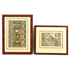
![[MAP] DELISLE, GUILLAUME Carte des Provinces Unie (1 of 1)](https://p1.liveauctioneers.com/292/8142/1390876_1_x.jpg?height=282&quality=70)
![[HOLLAND] DE LA POINTE, F. La Hollande (1 of 1)](https://p1.liveauctioneers.com/3336/110291/57703632_1_x.jpg?height=282&quality=70&version=1511544421)


![[MAPS]. DUFOUR, Auguste-Henri (1795-1865). Bound Volume of ... (1 of 2)](https://p1.liveauctioneers.com/928/318880/171361279_1_x.jpg?height=282&quality=70&version=1707501302)