ATLAS of ANTIENT GEOGRAPHY by SAMUEL BUTLER 1843John McInnis Auctioneers,LLC4.5(505)See Sold PriceFeb 25, 2024
18TH C. ANTIQUE MAP: FRENCH & INDIAN WAR, FRAMEDThomaston Place Auction Galleries4.4(393)See Sold PriceFeb 24, 2024
Rand McNally Railroad Map Cabinet w/ 21 Railroad MapsRail & Road Auctions4.6(165)See Sold PriceMar 08, 2024
Keith Haring - Ink on New York Map, Best Buddies, Inscribed, Signed, and DatedSapphire Auction Gallery4(67)See Sold PriceMar 02, 2024
LATE 17TH C. FRENCH MAP OF THE NEW WORLD BY ALEXIS-HUBERT JAILLOT (1632-1712)Thomaston Place Auction Galleries4.4(393)See Sold PriceFeb 24, 2024
Central Railroad of New Jersey Map of Sandy Hook Route-ca. 1903JM Hobby Supply and Railroad Artifact Auctions4.4(127)See Sold PriceFeb 24, 2024
Lot of Six Mixed Atlas Box Cars-HO Scale-New in BoxJM Hobby Supply and Railroad Artifact Auctions4.4(127)See Sold PriceFeb 25, 2024
Rand McNally/Santa Fe Railroad Map of Iowa-1912JM Hobby Supply and Railroad Artifact Auctions4.4(127)See Sold PriceFeb 24, 2024
NICOLAES VISSCHER (NETHERLANDS, 1618-1709) MAP OF THE NEW WORLDThomaston Place Auction Galleries4.4(393)See Sold PriceFeb 24, 2024
17TH C. WORLD MAP BY NICOLAES VISSCHER (NETHERLANDS, 1618-1709)Thomaston Place Auction Galleries4.4(393)See Sold PriceFeb 24, 2024
Lot of Six Mixed Atlas Cabooses-HO Scale-New in BoxJM Hobby Supply and Railroad Artifact Auctions4.4(127)See Sold PriceFeb 25, 2024
SoldRiver Lengths & Mountain Heights of the World, 1850Original engraving by Samuel Augustus Mitchell from Mitchell’s Universal Atlas, 1850. Dimensions: 14 x 17 inchesSee Sold Price
Sold1855 Johnston World Map with Comperative Chart ofTitle/Content: 1855 Johnston World Map with Comperative Chart of Rivers and Mountains -- The World in Hemispheres, with Comparative Views of the Heights of ths Principal Mountains and Lengths of the PSee Sold Price
1855 Johnston World Map with Comperative Chart ofTitle/Content of Map: 1855 Johnston World Map with Comperative Chart of Rivers and Mountains -- The World in Hemispheres, with Comparative Views of the Heights of ths Principal Mountains and Lengths oSee Sold Price
SoldMitchell: Rivers & Mountains of the World, 1848Lengths of the Principal Rivers in the World, Heights of the Principal Mountains of the World, S. Augustus Mitchell, 1848. 13 x 16 inches. Interesting and very desirable chart illustrating the principSee Sold Price
Sold1846 Map of Mountain & Rivers of the world1846 map of "Heights of the Principal mountains in the world; Lengths of the Principal Rivers in the world". By H N Burroughs, Pennsylvania. Colored engraving. 17 1/2" x 14" Possible owner signature oSee Sold Price
SoldLengths of Rivers/Hts. of Mts. – 1850 CowperthwaitBeautiful mid-19th century pictorial presentation of the major rivers and mountains in the world. “Lengths of the Principal Rivers in the World/Heights of the Principal Mountains in the World.” DaSee Sold Price
SoldGray Double Hemisphere World Map,18791879 Gray Double Hemisphere World Map -- Gray's New Map of the World in Hemispheres, with Comparative Views of the Heights of the Principal Mountains and Lengths of the Principal Rivers on the Globe.See Sold Price
Sold2 PCS, WORLD ENGRAVINGS BY COWPERTHWAIT, 1850Thomas Coperthwait and Company, Philadelphia. "World Map on the Globular Projection" and "Heights of the Principle Mountains of the World / Lengths of the Principle Rivers of the World" -both 1850, haSee Sold Price
SoldJohnson and Ward Mountains and Rivers Map, 1860'sJohnson (Alvin Jewitt Johnson, American, 1827-1884) and Benjamin P. Ward (American), "Mountains and Rivers" - Johnson’s Chart of Comparative Heights of Mountains and Lengths of Rivers of North AmeriSee Sold Price
Oil on Canvas, Signed Herman FuechselAmerican, oil on canvas, Landscape with a Mountain and River, signed Herman Fuechsel (1833-1915). Height 15 in., Length 24 in. Provenance: From the estate of a New York collector. Herman Fuechsel bornSee Sold Price
Sold1864 A.J. Johnson Print. Johnson's Chart of Comparative1864 A.J. Johnson Print. Johnson's Chart of Comparative Heights of Mountains, Lengths of Rivers of AFRICA. -- Dimensions: H: 24 inches: W: 17 inches -- FRAME SIZE: Frame Height 29.25 inches - Frame WiSee Sold Price
Sold1864 Johnson Chart of Mountains and Rivers perTitle: 1864 Johnson Chart of Mountains and Rivers per Continent -- Johnson's Chart of Comparative Heights of Mountains and Lengths of Rivers of Africa, Asia, Europe, South America and North America CaSee Sold Price
Impressive Mountains/Rivers, Johnson 1862One of the finest Mountains and River's Charts published in the mid-19th century. Eye-catching layout on this wonderful and original chart of heights of mountains and lengths of rivers. Great early prSee Sold Price
SoldWorld War II German Hat, Flag and ArmbandsWorld War II German Hat, Flag and Armbands Five items including SS banner, Hitler youth armband, two German Army armbands and an SS Mountain Division fez Height: 14.25 inches, Length: 18.25 inches (baSee Sold Price
SoldA. J. Johnson, "Comparative Heights of Mountains, andA. J. Johnson, "Comparative Heights of Mountains, and Lengths of Rivers in Africa, Asia, Europe, South America, North America," hand colored, 1864, 26 3/8 in., W.- 18 1/8 in.See Sold Price
Sold"Johnson's Chart of Comparative Heights of Mountains"Johnson's Chart of Comparative Heights of Mountains and Lengths of Rivers of Africa, Asia, Europe, South America and North America," 1864, presented in a gilt frame, H.- 23 3/4 in., W.- 17 in.See Sold Price
SoldA Republic period blue and white porcelain plaqueThis piece depicts a landscape scenery with mountains and flowing rivers. This piece also includes a wooden stand. Height 19.6 in, Length 14 in 民国著名画家何See Sold Price
SoldA Republic period blue and white porcelain plaqueThis piece depicts a landscape scenery with mountains and flowing rivers. This piece also includes a wooden stand. Height 19.6 in, Length 14 in 民国著å画家何许人See Sold Price
SoldA CHINESE GRISAILLE-PAINTED GILT-INLAID PORCELAINThe washer is of red glaze with grisaille-painted mountains and rivers on the body. Of hexagonal shape, it is with gilt inlaid. Length:9cm, Width:5.8cm, Height:5cm,See Sold Price
Sold1882 Mts. & Rivers of the Bible – H. H. HardestyUnusual, interesting hand colored map showing comparative height of the mountainsand comparative lengths of rivers mentioned in the Bible. Also shows “Countries of the Exile.” From the 1882 HistorSee Sold Price
WHITE JADE BOULDERChinese. The horizontal domical mountain incarved with figures and geese under a large pine tree with a river in the foreground emerging from a grotto. Height 3 7/8". Length 5 1/2". With a carved woodSee Sold Price
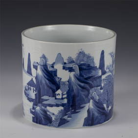
Large Blue And White Brush PotVery beautiful river bank landscape with mountains, and fisherman in the river. Standard blue color. Six Kang Xi mark on the base. 16.5cm height, 20cm diameter.See Sold Price
SoldLarge Blue and White Brush PotVery beautiful river bank landscape with mountains, and fisherman in the river. Standard blue color. Six Kang Xi mark on the base. 16.5cm height, 20cm diameter.See Sold Price
SoldEarly MapsWonderful collection of three hanging wall maps to include: Map #1 1861 Maine Map by H.E. Walling along with map of world, United States, graphic locations with mountains height and feet, side locatioSee Sold Price
LI KUCHAN'', VIEWING THE MOUNTAINS AND RIVERS FROM A DISTANCEMega International Auction4.3(62)See Sold PriceFeb 24, 2024
LIANG ZHAOTANG'S PIGEONS WHISPERING IN THE MOUNTAINS AND RIVERS, STANDING AXISMega International Auction4.3(62)See Sold PriceMar 23, 2024
Warne's Bijou Gazetteer by Rosser - Antique 1883Rapid Estate Liquidators and Auction Gallery4.5(1.1k)See Sold PriceFeb 28, 2024