ATLAS of ANTIENT GEOGRAPHY by SAMUEL BUTLER 1843John McInnis Auctioneers,LLC4.6(504)See Sold PriceFeb 24, 2024
18TH C. ANTIQUE MAP: FRENCH & INDIAN WAR, FRAMEDThomaston Place Auction Galleries4.4(389)See Sold PriceFeb 24, 2024
Rand McNally Railroad Map Cabinet w/ 21 Railroad MapsRail & Road Auctions4.6(165)See Sold PriceMar 08, 2024
Keith Haring - Ink on New York Map, Best Buddies, Inscribed, Signed, and DatedSapphire Auction Gallery4.1(67)See Sold PriceMar 02, 2024
LATE 17TH C. FRENCH MAP OF THE NEW WORLD BY ALEXIS-HUBERT JAILLOT (1632-1712)Thomaston Place Auction Galleries4.4(389)See Sold PriceFeb 24, 2024
Central Railroad of New Jersey Map of Sandy Hook Route-ca. 1903JM Hobby Supply and Railroad Artifact Auctions4.4(126)See Sold PriceFeb 24, 2024
Lot of Six Mixed Atlas Box Cars-HO Scale-New in BoxJM Hobby Supply and Railroad Artifact Auctions4.4(126)See Sold PriceFeb 25, 2024
Rand McNally/Santa Fe Railroad Map of Iowa-1912JM Hobby Supply and Railroad Artifact Auctions4.4(126)See Sold PriceFeb 24, 2024
NICOLAES VISSCHER (NETHERLANDS, 1618-1709) MAP OF THE NEW WORLDThomaston Place Auction Galleries4.4(389)See Sold PriceFeb 24, 2024
17TH C. WORLD MAP BY NICOLAES VISSCHER (NETHERLANDS, 1618-1709)Thomaston Place Auction Galleries4.4(389)See Sold PriceFeb 24, 2024
Lot of Six Mixed Atlas Cabooses-HO Scale-New in BoxJM Hobby Supply and Railroad Artifact Auctions4.4(126)See Sold PriceFeb 25, 2024
Sold1879 GERMAN MAP OF THE WORLD, GLOBULAR PROJECTION14 x 16. 5 inch sight size, slipped down in matte. Appears very good.See Sold Price
SoldArrowsmith, Aaron 1825 Rare World Hemisphere Map"World on Globular Projection" Steel Engraved Map Published 1825, London for "Outlines Of The World" by Aaron Arrowsmith. Rare. Outline hand color. Paper Size: 15 x 10.5 inch (37 x 27cm) Top margin slSee Sold Price
Bradford: Set of 2 Antique Maps, World in HemispheresTitle/Content of Map: Set of 2 Maps together World in globular projection by Bradford Date Printed: 1835 Cartographer: T.G. Bradford Material/Medium: Paper Size: 9 1/2" x 13" each A comprehensive AtlaSee Sold Price
Sold3 Maps incl: Map Of Boston And Adjacent Cities.[World/ Massachusetts/Europe] 3 Maps. ++ A New Map Of The World On The Globular Projection. Phila: Thomas, Cowperthwait & Co., (1850). Hemispheres. Outer edge of overall border: 9 1/2 x 14 1/8 in. TonSee Sold Price
SoldRARE 1852 WORLD MAP GLOBULAR COWPERTHWAIT & COA New Map of the World on the Globular Projection, 1852. Published by Thomas Cowperthwait & Co. No.253 Market Street, Philadelphia. Hand colored and framed. Paper measures 14.5 by 9.5 inches. Frame meSee Sold Price
Sold2 PCS, WORLD ENGRAVINGS BY COWPERTHWAIT, 1850Thomas Coperthwait and Company, Philadelphia. "World Map on the Globular Projection" and "Heights of the Principle Mountains of the World / Lengths of the Principle Rivers of the World" -both 1850, haSee Sold Price
SoldRYE ACADEMY GLOBULAR PROJECTION MAP OF THE WORLDRYE ACADEMY GLOBULAR PROJECTION MAP OF THE WORLDc. 1831, watercolor, pen & ink, and lithography on paper, 22 1/2 x 33 1/2 in.See Sold Price
RYE ACADEMY GLOBULAR PROJECTION MAP OF THE WORLDSgd. Miss -- W. Lyon and dated c. 1831, watercolor, pen & ink, and lithography on paper, 22 1/2 x 33 1/2 in.See Sold Price
Sold(Maps and Charts, World Projection), Waldseemuelle(Maps and Charts, World Projection), Waldseemueller, Martin (1470?-1518?), Tabu Gran Russie [Tabula Grandlandie et Russie], Strassburg: Johannes Gr?ninger, c. 1522, uncolored woodblock, one page of teSee Sold Price
Sold(Maps and Charts, World Projection) Muenster, Seba(Maps and Charts, World Projection), Muenster, Sebastian (1489-1552), Typus Orbis Universalis, [Basel, 1552 or later], woodblock folio print with hand coloring, with Latin text to verso, 12 3/8 x 15 1See Sold Price
SoldDecorative Hand-colored World Projection Map afteDecorative Hand-colored World Projection Map after Joannes Jansson, 16 3/4 x 22 in., framed.See Sold Price
Sold(Maps and Charts, World Projection), Waldseemuelle(Maps and Charts, World Projection), Waldseemueller, Martin (1470?-1518?), Tabu[la] totius orbis, [Lyons, 1535 or later], uncolored woodcut, double-page folio, unframed, (light edge toning, small chipSee Sold Price
Sold(Maps and Charts, World Projection), Two maps: Tir(Maps and Charts, World Projection), Two maps: Tirion, Isaak, Nieuwe Kaart van het Oostelykste der Weerald..., and Nieuwe Kaart van het Westelykste Deel der Weerald..., Amsterdam, 1753-54, folio, uncoSee Sold Price
Sold(Maps and Charts, World Projection, 16th Century),(Maps and Charts, World Projection, 16th Century), Waldseemuller, Martin, Orbis Typus Universalis Iuxta Hygrographorum, Strasbourg, 1513 or later, uncolored, 609 x 465 mm, (hinged to mat, restorationSee Sold Price
Sold(Maps and Charts, World Projection, 15th Century),(Maps and Charts, World Projection, 15th Century), Schedel, Hartmann, Secunda etas mundi, [1493 or later], taken from Liber chronicarum, Nuremberg: Anton Koberger, leaf XII/XIII, uncolored, with textSee Sold Price
SoldHolbrook Miniature Teaching GlobeLate 19th century, Holbrooks Manufacturing Company, Wethersfield, CT, the exterior with hand colored continental borders, the interior with the same having Mercator's style world projection., signed oSee Sold Price
SoldAmerican Hand Colored Pocket GlobeLate 19th century, Holbrooks Manufacturing Company, Wethersfield, CT, the exterior with hand colored continents, the interior with the same having Mercator's style world projection., 3" dia.See Sold Price
SoldMitchell: Antique Map of the World; Mercator ProjectionTitle: Map of the World on the Mercator Projection Maker: Samuel A. Mitchell Date: 1867 Dimensions (inches): 23 x 15 Medium: Hand Colored Lithograph Condition: Great Condition Samuel Augustus MitchellSee Sold Price
SoldWorld Atlantis Projection U.N. Member States 1952 MapWorld (Atlantis Projection). United Nations Member States. Bartholomew 1952 Map. Title/content of Map: 'United Nations' date Printed: 1952 image Size: Approx 33.0 X 21.0cm, 13 X 8.25 Inches (large) tySee Sold Price
SoldJohnson: Antique Map of Globular World, 1868Title/Content of Map: Globular World Date Printed: 1868 Cartographer: A.J. Johnson Material/Medium: Paper Size: 18" x 23 3/4" Hand colored engraved Map. From Johnson's Illustrated Family Atlas of theSee Sold Price
SoldGlobular World: Western & Eastern Hemispehere, 1868Original engraving from Johnson's Atlas of the World, 1868. Map includes vignette of Long Island & cities, towns and territories. Dimensions: 18" x 26". No Reserve This item ships from Ocean View, DE.See Sold Price
SoldMap of World / Mercators Projection, 1868Original engraving from Johnson's Atlas of the World, 1868. Map includes vignette of Long Island & cities, towns and territories. Dimensions: 18" x 26". Shipping Domestic: Shipping rates are determindSee Sold Price
SoldGeneral Chart on Mercators Projection. World. Cook's route. PAYNE 1798 old mapTITLE/CONTENT OF MAP: 'General Chart on Mercators Projection' DATE PRINTED: 1798 IMAGE SIZE: Approx 18.0 x 25.0cm, 7 x 9.75 inches (Medium) TYPE: Antique copperplate engraved map with original hand coSee Sold Price
Arrowsmith & Lewis - Map of the World on Mercator's ProjectionTrillium Antique Prints & Rare Books4.5(30)See Sold PriceFeb 24, 2024
Carey, pub. 1796 - A Chart of the West IndiesTrillium Antique Prints & Rare Books4.5(30)See Sold PriceFeb 24, 2024
Carey, pub. 1796 - Map of the State of MarylandTrillium Antique Prints & Rare Books4.5(30)See Sold PriceFeb 24, 2024
Carey, pub. 1796 - Map of GeorgiaTrillium Antique Prints & Rare Books4.5(30)See Sold PriceFeb 24, 2024
Carey, pub. 1796 - Map of The State of South CarolinaTrillium Antique Prints & Rare Books4.5(30)See Sold PriceFeb 24, 2024
Carey, pub. 1796 - Map of KentuckyTrillium Antique Prints & Rare Books4.5(30)See Sold PriceFeb 24, 2024
Carey, pub. 1796 - Map of the Tennassee State formerly part of North Carolina (Tennessee)Trillium Antique Prints & Rare Books4.5(30)See Sold PriceFeb 24, 2024
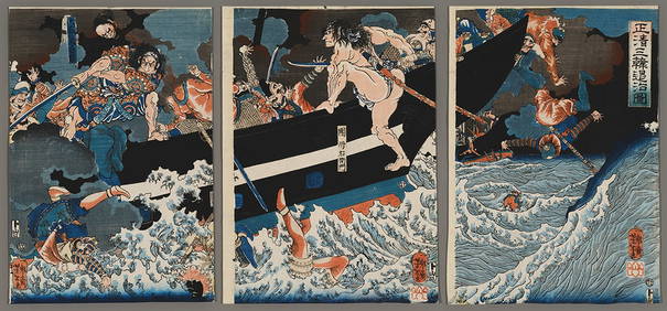
Yoshitoshi Woodblock - Masakiyo Conquers KoreaFloating World Auctions4.7(233)See Sold PriceMar 01, 2024
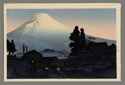
Shotei Hiroaki Woodblock - Fuji From MizukuboFloating World Auctions4.7(233)See Sold PriceMar 01, 2024
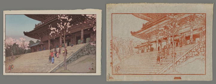
Hiroshi Yoshida Woodblock Set - Chion-in Temple GateFloating World Auctions4.7(233)See Sold PriceMar 01, 2024
Blackie (Pub) 1882 Folio Map. World on Mercators ProjectionAlbion Auctions4.6(341)See Sold PriceMar 01, 2024
"Sazikov" Antique Russian Silver Large SteinWorld Auction Gallery LLC4.7(264)See Sold PriceMar 10, 2024


![[Map] Johnson's Globular World (1 of 4)](https://p1.liveauctioneers.com/523/84219/43476535_1_x.jpg?height=282&quality=70&version=1453240168)