ATLAS of ANTIENT GEOGRAPHY by SAMUEL BUTLER 1843John McInnis Auctioneers,LLC4.5(505)See Sold PriceFeb 24, 2024
18TH C. ANTIQUE MAP: FRENCH & INDIAN WAR, FRAMEDThomaston Place Auction Galleries4.4(393)See Sold PriceFeb 24, 2024
Rand McNally Railroad Map Cabinet w/ 21 Railroad MapsRail & Road Auctions4.6(165)See Sold PriceMar 08, 2024
Keith Haring - Ink on New York Map, Best Buddies, Inscribed, Signed, and DatedSapphire Auction Gallery4.1(67)See Sold PriceMar 02, 2024
LATE 17TH C. FRENCH MAP OF THE NEW WORLD BY ALEXIS-HUBERT JAILLOT (1632-1712)Thomaston Place Auction Galleries4.4(393)See Sold PriceFeb 24, 2024
Central Railroad of New Jersey Map of Sandy Hook Route-ca. 1903JM Hobby Supply and Railroad Artifact Auctions4.4(127)See Sold PriceFeb 24, 2024
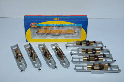
Lot of Six Mixed Atlas Box Cars-HO Scale-New in BoxJM Hobby Supply and Railroad Artifact Auctions4.4(127)See Sold PriceFeb 25, 2024
Rand McNally/Santa Fe Railroad Map of Iowa-1912JM Hobby Supply and Railroad Artifact Auctions4.4(127)See Sold PriceFeb 24, 2024
NICOLAES VISSCHER (NETHERLANDS, 1618-1709) MAP OF THE NEW WORLDThomaston Place Auction Galleries4.4(393)See Sold PriceFeb 24, 2024
17TH C. WORLD MAP BY NICOLAES VISSCHER (NETHERLANDS, 1618-1709)Thomaston Place Auction Galleries4.4(393)See Sold PriceFeb 24, 2024
Lot of Six Mixed Atlas Cabooses-HO Scale-New in BoxJM Hobby Supply and Railroad Artifact Auctions4.4(127)See Sold PriceFeb 25, 2024
WORLD KNOWN TO ANCIENTS. Herodotus Ptolemy Pliny Hanno. On 2 sheets 1845 mapTITLE/CONTENT OF MAP: 'THE WORLD AS KNOWN TO THE ANCIENTS' DATE PRINTED: 1845 IMAGE SIZE: Approx 41.5 x 64.5cm, 16.25 x 25.5 inches (Large) TYPE: Antique steel engraved map with original outline handSee Sold Price
WORLD KNOWN TO ANCIENTS. Herodotus Ptolemy Pliny Hanno. On 2 sheets 1857 mapTITLE/CONTENT OF MAP: 'THE WORLD AS KNOWN TO THE ANCIENTS' DATE PRINTED: 1857 IMAGE SIZE: Approx 41.5 x 64.5cm, 16.25 x 25.5 inches (Large) TYPE: Antique steel engraved map with original hand colourinSee Sold Price
WORLD KNOWN TO ANCIENTS. Herodotus Ptolemy Pliny Hanno. SDUK 1874 old mapTITLE/CONTENT OF MAP: 'THE WORLD AS KNOWN TO THE ANCIENTS' DATE PRINTED: 1874 IMAGE SIZE: Approx 42.0 x 63.0cm, 16.5 x 24.75 inches (Large) TYPE: Antique steel engraved map with original outline handSee Sold Price
WORLD KNOWN TO ANCIENTS. Herodotus Ptolemy Pliny Hanno. SDUK 1856 old mapTITLE/CONTENT OF MAP: 'THE WORLD AS KNOWN TO THE ANCIENTS' DATE PRINTED: 1856 IMAGE SIZE: Approx 41.5 x 64.5cm, 16.25 x 25.5 inches (Large) TYPE: Antique steel engraved map with original outline handSee Sold Price
WORLD KNOWN TO ANCIENTS. Herodotus Ptolemy Pliny Hanno.TITLE/CONTENT OF MAP: 'THE WORLD AS KNOWN TO THE ANCIENTS' The top image on the right hand side shows the entire map. To view a close up of the map showing the level of printed detail, please click onSee Sold Price
WORLD AS KNOWN TO ANCIENTS Herodotus Hanno Ptolemy Pliny SDUK 1844 old mapTITLE/CONTENT OF MAP: 'THE WORLD AS KNOWN TO THE ANCIENTS' DATE PRINTED: This map was originally published by Chapman & Hall in 1842; this date is printed on the map. This edition of the map was printSee Sold Price
Sold6 Maps published by Chapman & Hall, 1830-1842.[Mideast/Northern Africa/Ancient Geography]. 6 Maps. Prtd outline color. ++ The World As Known To The Ancients. Uses information from Hanno, Pliny, and Ptolemy. In margin at lower right: “Drawn by RSee Sold Price
Stanford Map of the WorldSTANFORD, Edward (1827-1904). The World as known to the Ancient (2 sheets). Lithograph with original hand color from the Society for the Diffusion of Useful Knowledge. London: Edward Stanford, 1857-18See Sold Price
SoldLavoisne (C.V.) Chart of the World[Lavoisne (C.V.)] Chart of the World, as known to the Ancients,... Division of the Earth among the Posterity of Noah, 2 maps on one sheet, engraved by J. Walker, with full original hand-colourSee Sold Price
Ortelius Map of the Ancient WorldORTELIUS, Abraham (1527-1598).Aevi Veteris, Typus Geographicus.Engraved Map.Antwerp: 1601.23" x 18 1/2" sheet.Stunning Ortelius Map of the Ancient World, Based on the Work of Claudius Ptolemy. DecoratSee Sold Price
SoldGroup of [4] World Maps by Various CartographersGroup of four World Maps by various cartographers and publishers. 1) W. Houghs "The World as Known to the Ancients" published by A. & C. Black. Measures 17.5" x 12.5" sheet size. 2) Engraved by J. WilSee Sold Price
SoldPtolemy / Waldseemuller World MapGenerale Ptholemei...(World). Claudius Ptolemaues & Martin Waldseemuller. Woodcut Map. Strasbourg: J. Schott, 1513 or 1520. 17 1/2 x 22 3/4 inches sheet, 29 x 34 inches framed. The Strasbourg PtolemySee Sold Price
SoldLong’s Classical Atlas w/hand-colored maps, 1856Reserve Reduced! Atlas with 26 two-page plates in outline hand-color. All maps in fine condition. Maps are all 10 x 13 sheets. Maps include (1) Geography According to the Ancients, (2) The World as KnSee Sold Price
SoldAtlas.- D'Anville (J.B.B.) - [Composite Atlas],manuscript contents leaf headed 'Table de l'Atlas de Mr. Danville', and 46 single, double and folding map sheets to form 33 maps, including 8 of the ancient world, 2 of the hemispheres, several of NorSee Sold Price
D'Anville (J.B.B.) - [Composite Atlas],manuscript contents leaf headed 'Table de l'Atlas de Mr. Danville', and 46 single, double and folding map sheets to form 33 maps, including 8 of the ancient world, 2 of the hemispheres, several of NorSee Sold Price
MAP, Caucasus & Russia, MaginiCaucasus, Russia & Ukraine. Ptolemy/Magini, Tabula Asiae II, 1598 (circa). Black & White. This Ptolemaic map, presented on a trapezoidal projection, presents a slice of the ancient world known as SarmSee Sold Price
MAP - Caucasus & Central Asia. MaginiCaucasus & Central Asia. Ptolemy/Magini, Tabula Asiae II, 1621 (published). Black & White. This Ptolemaic map, presented on a trapezoidal projection, presents a slice of the ancient world known as SarSee Sold Price
1820. Chart of the world as known to the Ancients,Title/Content of Map: 1820. Chart of the world as known to the Ancients, Divisions among the Posterity of Noah by Lavoisne. Size: 17 1/2” x 21 1/2” Published by Carey and Son in Philadelphia. PleaSee Sold Price
SoldDouble Map - Chart of the World as Known to the ADouble Map - Chart of the World as Known to the Ancients on Mercator's Scale & Division of Earth Among The Posterity of Noah # 6 - M. Carey, 1820 - 17 1/2" x 22"See Sold Price
1820. Chart of the world as known to the Ancients,Reserve Reduced! 17 1/2” x 21 1/2” Reserve: $40.00 Jasper52 negotiates the lowest reserves so bidders always get the best prices. Shipping: Domestic: Free shipping to anywhere within the contiguouSee Sold Price
1820. Chart of the world as known to the Ancients,1820. Chart of the world as known to the Ancients, Divisions among the Posterity of Noah by Lavoisne. Published by Carey and Son in Philadelphia. 17 1/2” x 21 1/2”. Please note that this lot has aSee Sold Price
MAP, Eastern Europe, MercatorEastern Europe. Ptolemy/Mercator, Eur: VIII. Tab:, 1618 (published). Hand Color. Attractive Ptolemaic map covering eastern Europe from the Baltic through the Black Sea known in ancient times as SarmatSee Sold Price
SoldPTOLEMAEUS - PTOLEMY. World map. 1478 or 1490WORLD MAP- PTOLEMAEUS [Untitled world map][Rome: 1478 or 1490]. Double-page engraved map of the ancient world, on two sheets joined, (392 x 555 mm), verso of centre with pasted paper backstriSee Sold Price
MAP - Eastern Europe. Ptolemy/MercatorEastern Europe. Ptolemy/Mercator, Eur: VIII. Tab:, 1618 (published). Hand Color. Attractive Ptolemaic map covering eastern Europe from the Baltic through the Black Sea known in ancient times as SarmatSee Sold Price
29 New Athearn Motors and Chassis-HO Scale F Units and OthersJM Hobby Supply and Railroad Artifact Auctions4.4(127)See Sold PriceFeb 25, 2024
29 New Athearn Motors and Chassis-HO Scale F Units and OthersJM Hobby Supply and Railroad Artifact Auctions4.4(127)See Sold PriceFeb 25, 2024
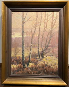
Naturalist landscape by 20th century Swedish artistBert Gallery Studio Sales4.4(18)See Sold PriceFeb 27, 2024
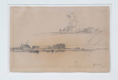
ATTRIBUTED TO WINSLOW HOMER (ME/MA/UK, 1836-1910)Thomaston Place Auction Galleries4.4(393)See Sold PriceFeb 24, 2024
NICOLAES VISSCHER (NETHERLANDS, 1618-1709) MAP OF THE NEW WORLDThomaston Place Auction Galleries4.4(393)See Sold PriceFeb 24, 2024
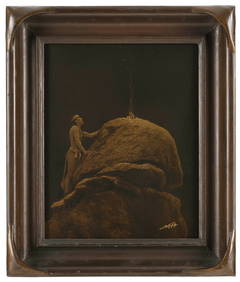
EDWARD SHERRIFF CURTIS (Washington/California, 1868-1952), "Signal Fire to the Mountain God", 1912.,Eldred's4.7(419)See Sold PriceFeb 28, 2024
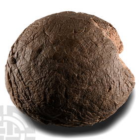
Natural History - Fossil Hadrosaur Dinosaur EggTimeLine Auctions Ltd.4.6(183)See Sold PriceMar 05, 2024
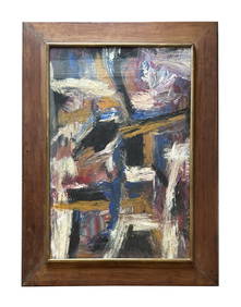
Christo Vladimirov Javacheff (1935-2020) and Jeanne-Claude Denat de Guillebon (1935-2009), known asNeely Auction4.6(224)See Sold PriceFeb 25, 2024
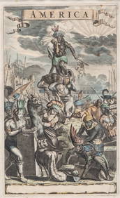
Antique Hand Colored Print "America" by Jacob van MeursCollective Hudson4.5(58)See Sold PriceMar 01, 2024
[BUSINESS]. Travel Guide of Negro Hotels and Guest Houses. Published by Afro-American Newspapers ofFreeman's | Hindman4.4(1.6k)See Sold PriceFeb 27, 2024
Hamaguchi Mezzotint - Three Butterflies (Orange)Floating World Auctions4.7(236)See Sold PriceMar 01, 2024
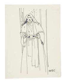
STAR WARS: A NEW HOPE (1977) - William Plumb Collection: Hand-drawn Moebius Obi-Wan Kenobi SketchPropstore4.2(6)See Sold PriceMar 13, 2024
RARE MANHATTAN PROJECT GLASS LEADED FROM THE MANHATTAN PROJECT WORLD WAR II WW2 724 GRAMSCol. Christie Hatman Auctioneers4.5(333)See Sold PriceFeb 26, 2024


![Group of [4] World Maps by Various Cartographers (1 of 5)](https://p1.liveauctioneers.com/5755/131248/66701959_1_x.jpg?height=282&quality=70&version=1542156595)


![Atlas.- D'Anville (J.B.B.) - [Composite Atlas], (1 of 2)](https://p1.liveauctioneers.com/410/84263/43496530_1_x.jpg?height=282&quality=70&version=1453293226)
![D'Anville (J.B.B.) - [Composite Atlas], (1 of 2)](https://p1.liveauctioneers.com/410/80717/41962759_1_x.jpg?height=282&quality=70&version=1445353131)


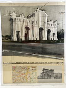

![[BUSINESS]. Travel Guide of Negro Hotels and Guest Houses. Published by Afro-American Newspapers of (1 of 4)](https://p1.liveauctioneers.com/197/319238/171467937_1_x.jpg?height=282&quality=70&version=1707520367)