ATLAS of ANTIENT GEOGRAPHY by SAMUEL BUTLER 1843John McInnis Auctioneers,LLC4.6(504)See Sold PriceFeb 24, 2024
18TH C. ANTIQUE MAP: FRENCH & INDIAN WAR, FRAMEDThomaston Place Auction Galleries4.4(389)See Sold PriceFeb 24, 2024
Rand McNally Railroad Map Cabinet w/ 21 Railroad MapsRail & Road Auctions4.6(165)See Sold PriceMar 08, 2024
Keith Haring - Ink on New York Map, Best Buddies, Inscribed, Signed, and DatedSapphire Auction Gallery4.1(67)See Sold PriceMar 02, 2024
LATE 17TH C. FRENCH MAP OF THE NEW WORLD BY ALEXIS-HUBERT JAILLOT (1632-1712)Thomaston Place Auction Galleries4.4(389)See Sold PriceFeb 24, 2024
Central Railroad of New Jersey Map of Sandy Hook Route-ca. 1903JM Hobby Supply and Railroad Artifact Auctions4.4(126)See Sold PriceFeb 24, 2024
Lot of Six Mixed Atlas Box Cars-HO Scale-New in BoxJM Hobby Supply and Railroad Artifact Auctions4.4(126)See Sold PriceFeb 25, 2024
Rand McNally/Santa Fe Railroad Map of Iowa-1912JM Hobby Supply and Railroad Artifact Auctions4.4(126)See Sold PriceFeb 24, 2024
NICOLAES VISSCHER (NETHERLANDS, 1618-1709) MAP OF THE NEW WORLDThomaston Place Auction Galleries4.4(389)See Sold PriceFeb 24, 2024
17TH C. WORLD MAP BY NICOLAES VISSCHER (NETHERLANDS, 1618-1709)Thomaston Place Auction Galleries4.4(389)See Sold PriceFeb 24, 2024
Lot of Six Mixed Atlas Cabooses-HO Scale-New in BoxJM Hobby Supply and Railroad Artifact Auctions4.4(126)See Sold PriceFeb 25, 2024
SoldFramed Hudson River Map PrintPiece depicts a map of the HUDSON RIVER. PIECE Is professionally framed with black toned metal frame. Map, map print, framed map. Glass has small cracks near corner. Piece measures approximately 44 inSee Sold Price
Sold2 Stacking Oak Map Print Cases. Each cabinet with2 Stacking Oak Map Print Cases. Each cabinet with 5 shallow long horizontal drawers. Metal pulls. -- Dimensions: H: 30.5 inches: W: 45.75 inches: D: 35.5 inches ---See Sold Price
SoldAFTER WILLIAM SANDUSKY 1845 GALVESTON TEXAS MAP PRINTFramed print on paper, "Plan of the City of Galveston, Texas," a reproduction after the original created by William H. Sandusky (William Harrison Sandusky, Ohio, Texas, 1813-1847), in1845, lithographiSee Sold Price
Sold3pc Stacking Industrial Metal Map Print Cabinet.3pc Stacking Industrial Metal Map Print Cabinet. Gray metal 5 drawer sections. Some drawers are lined. Silver chrome pulls. Marked HAMILTON.-- Dimensions: H: 49.75 inches: W: 41 inches: D: 29.5 inchesSee Sold Price
Sold1926 Tony Sarg Nantucket Map Print1926 Tony Sarg (1880-1942) Nantucket Map Print 15 in. x 18 in. Overall 22 in. x 24 in.See Sold Price
SoldLarge Contemporary Florence Map Print TapestryLarge Contemporary Florence Map Print Tapestry. Map of Florence printed on canvas with wood pediment and rod. Measures approximately 74 inches x 100 inches.See Sold Price
SoldGerman Moscovia Map PrintTitled "Mosvavw", hand colored, note on verso "Braun and Hogenburg, Cologne c. 1585 The earliest obtainable map or view of Moscow". Map, 15-1/2" x 21", framed 22-1/2" x 28"See Sold Price
SoldJennifer Smith Native American Tribes Map Print 1989 USJennifer Smith Native American Tribes Map Print 1989 US And Canada 16â€Â x 19â€Â H **Age appropriate condition, as seen in photosSee Sold Price
SoldOversized Industrial Commercial Oak Map Print CheOversized Industrial Commercial Oak Map Print Chest. Metal handles, panel sides. Antique.-- Dimensions: H: 65.5 inches: W: 63 inches: D: 25 inches ---See Sold Price
SoldNorddeutscher Lloyd Bremen Ocean Liner Map PrintNorddeutscher Lloyd Bremen Ocean Liner Map Print framed under ship with steamships Munchen and Columbus. Measurements in inches: 45 x 33, Image: 39 x 27 Condition:Some wear to frame, print is clean ShSee Sold Price
Sold19C Oak Map Print Paper Collector's Case CabinetUnited States,Late 19th Century Six long drawers with bin pulls on a molded base, used for holding works on paper including maps and blueprints. Oak 57" x 36" x 32", From an Exeter, Rhode Island estatSee Sold Price
SoldAstronomy Antique Map PrintCelestial Planisphere astronomy chart of stars, constellations, milky way. F.J. Huntington, Hartford, Connecticut: c. 1835 15 3/4" x 23 3/4".See Sold Price
SoldAndrew Wyeth / Chris Sanderson Chester Co. Map PrintAndrew Wyeth / Chris Sanderson print, "Map of Historical Chester County". Framed under glass. Frame opening: 22-1/4 in x 24-1/4 in.See Sold Price
Sold1600s View of Mexico Hand Colored Map PrintNot sure when this was printed, but probably 18th or early 19th century. It has been in its current for about 100 years. Image size is 9 x 10.5, but is larger with border. Framed to 12.75 x 14.75. ImaSee Sold Price
SoldVintage Celestial Map PrintHand colored, fold lie down middle. As is. 17 X 20" (23" X 26"). (Property of a Mamaroneck NY Private Collector)"See Sold Price
SoldShag 50th Anniversary Disneyland Map Print.(Disneyland, 2005) A stylish map print by the artist Shag that was created for Disneyland's 50th anniversary. Depicting the park as it is remembered from its earliest years, this popular print measureSee Sold Price
SoldPr STACOR Stacking Map Print Chests. Blond wood cPr STACOR Stacking Map Print Chests. Blond wood case & drawers. Marked.-- Dimensions: H: 41 inches: W: 40.75 inches: D: 28.5 inches ---See Sold Price
SoldThe Red Sea or Arabic Gulph Map PrintOverall with frame 30-1/2" high x 9-1/4'' wide. Some discoloration to paper. Some losses to frame.See Sold Price
SoldAndrew Wyeth/Chris Sanderson Chester Co. Map PrintAndrew Wyeth and Chris Sanderson print, "Map of Historical Chester County". Framed under glass. Frame opening: 23-1/4 x 25 in.See Sold Price
SoldAN ANTIQUE AMERICAN TOPOGRAPHICAL MAP PRINT CharlesAN ANTIQUE AMERICAN TOPOGRAPHICAL MAP PRINT Charles Blaskowitz. Map 76 cm x 52 cm.See Sold Price
SoldIllustrated Harbor Landscape of Antwerp Map PrintEurope,19th Century Depicts Antwerp's skyline in the back with ships scattered throughout the water and a nude man holding an oar in the foreground. Lithograph,22" x 62", From the collection of a LehiSee Sold Price
SoldAntique Map Print - America - Mexico - Brazil - California - Vaugondy - 1806Title: Antique Map Print - America - Mexico - Brazil - California - Vaugondy - 1806 Description: Original 1806 copper-engraved map by Robert de Vaugondy on the Mercator projection. Derived from "NouveSee Sold Price
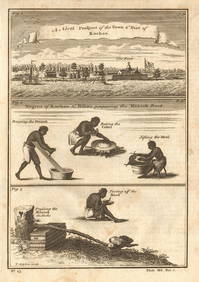
Guinea-Bissau Cacheu town Fortaleza de São José da Amura Preparing cassava 1745Jasper524.5(9.8k)See Sold PriceFeb 28, 2024
Nigeria & Chad. French West & Equatorial Africa. Cameroon. TIMES 1956 old mapJasper524.5(9.8k)See Sold PriceFeb 28, 2024
Africa. French Equatorial Africa. Rhodesia. Belgian Congo. TIMES 1956 old mapJasper524.5(9.8k)See Sold PriceFeb 28, 2024
Morocco Algeria. French & Spanish West Africa. Sahara sand dunes. TIMES 1956 mapJasper524.5(9.8k)See Sold PriceFeb 28, 2024
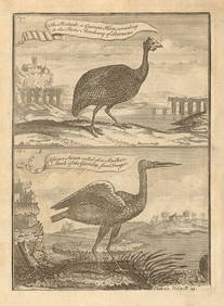
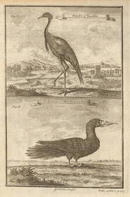
Pintado or Guinea-Hen. African Swan, or Gambian Stork. West African birds 1745Jasper524.5(9.8k)See Sold PriceFeb 28, 2024
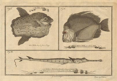
Ocean sunfish. Opah Moonfish. Orsie Petinbuaba Filefish. West African Fish 1745Jasper524.5(9.8k)See Sold PriceFeb 28, 2024
ANCIENT AFRICA cum Aegypto et Insulis. Nigritae Aethiopia. ARROWSMITH 1828 mapJasper524.5(9.8k)See Sold PriceFeb 28, 2024
AFRICA. European Possessions in Central; map of Zanzibar 1907 old antiqueJasper524.5(9.8k)See Sold PriceFeb 28, 2024
West African fruit. Kola nut. Guava fruit. Kalabash Calabash tree 1745 printJasper524.5(9.8k)See Sold PriceFeb 28, 2024
Gambian birds. Monoceros. A bird with four wings. CHILD 1745 old antique printJasper524.5(9.8k)See Sold PriceFeb 28, 2024
Bougainville's 1766 circumnavigation. France-Africa-Réunion. GENTS MAG 1774 mapJasper524.5(9.8k)See Sold PriceFeb 28, 2024
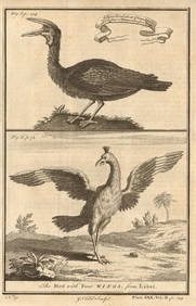
West African Birds. Crane Demoiselle. Alcatrazi or Mad-Bird. Albatross 1745Jasper524.5(9.8k)See Sold PriceFeb 28, 2024
MAGHREB. North Africa. Marocco Algeria and Tunis. BLACKIE 1886 old antique mapJasper524.5(9.8k)See Sold PriceFeb 28, 2024
COLONIAL CENTRAL AFRICA. Kenya Tanzania Belgian Congo Angola. JOHNSTON 1912 mapJasper524.5(9.8k)See Sold PriceFeb 28, 2024
Central Africa. Map showing great forest traversed by Mr Stanley, 1890Jasper524.5(9.8k)See Sold PriceFeb 28, 2024
French West Africa. Gold Coast. Sahara desert sand dunes. TIMES 1956 mapJasper524.5(9.8k)See Sold PriceFeb 28, 2024
ANCIENT NORTH AFRICA Septentrionalis. Mauretania Tripolitana ARROWSMITH 1828 mapJasper524.5(9.8k)See Sold PriceFeb 28, 2024
AFRICA. French North Africa and Morocco 1907 old antique map plan chartJasper524.5(9.8k)See Sold PriceFeb 28, 2024
COLONIAL CENTRAL AFRICA. Kenya Tanzania Belgian Congo Angola. JOHNSTON 1913 mapJasper524.5(9.8k)See Sold PriceFeb 28, 2024
EARLY COLONIAL WEST AFRICA. Empires of Sokoto Gando Mas.Tribes.Fellatah 1886 mapJasper524.5(9.8k)See Sold PriceFeb 28, 2024
West Africa gold trinkets worn as spells and utensils. jewels ornaments 1745Jasper524.5(9.8k)See Sold PriceFeb 28, 2024
Vintage Framed Cat Island Nautical Map PrintRapid Estate Liquidators and Auction Gallery4.5(1.1k)See Sold PriceFeb 25, 2024
Framed Tropical West Indies Map PrintRapid Estate Liquidators and Auction Gallery4.5(1.1k)See Sold PriceFeb 26, 2024