SoldWilliam Faden Map of Sicily & 4 others.William Faden coloured engraving, Map of Sicily, 1813, 34 x 48 ins. a map of Italy and 3 other maps.See Sold Price
SoldWilliam Faden Map of Scotland & 2 others.William Faden coloured engraving, Map of Scotland, sectional, 44 x 38 ins. a Cary of Northumberland and a Wyld of Great Britain.See Sold Price
SoldWilliam Faden mapWilliam Faden- ''North America, with the New Discoveries''- map mounted on fabric, poor condition. 13 1/2 x 15 3/4''See Sold Price
SoldCoxe Account of the Russian DiscoveriesCoxe (William) Account of the Russian Discoveries between Asia and America, fourth edition, engraved frontispiece map, 4 other maps and charts and 1 plate, offsetting, contemporary half straigSee Sold Price
SoldWilliam Faden 1793 Map of Eastern United StatesThe United States of North American: with the British Territories and Those of Spain, according to the Treaty of 1784, Engraved by Wm Faden 1793. 25-3/4"h x 38"wSee Sold Price
SoldGrp: 4 Maps of South America and the Caribbean SaGroup of four maps of South America and the Caribbean. Includes William Faden (1749–1836), "New Andalusia or Province of Guyana, according to the modern Division of the Spaniards, which extendsSee Sold Price
SoldSketch of the Surprise of GermantownSketch of the Surprise of Germantown... John Hills (fl. 1777-1816) & William Faden (1749-1836). Engraved map. London: Faden, 1784. 21 3/4 x 30 1/2 inches sheet. Hills’ magnificent plan of the BattleSee Sold Price
SoldNorfolk.- Faden (William) A Topographical Map of tNorfolk.- Faden (William) A Topographical Map of the County of Norfolklarge map in 4 sections, by T. Donald & T. Milne, with 3 inset plans of Lynn, Swaffham and Great Yarmouth, with a decoSee Sold Price
SoldFaden. A New Map of Spain and PortugalFaden (William) A New Map of Spain and Portugal,engraved map in 4 parts, original outline hand-colouring, dissected and linen-backed, each 565 x 785mm., original board slip-case, worn, 8vo, 18See Sold Price
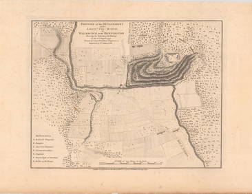
SoldFaden (William) - The Country Twenty-Five Miles Round3rd edition, unjoined 4-sheet map, from Ware to Redhill, and from Beaconsfield to Basildon, on a scale of one inch to a mile, oval title cartouche upper left, engraved map with original hand-colouringSee Sold Price
SoldWittman (William) Travels Turkey, Asia-MinorWittman (William) Travels in Turkey, Asia-Minor, Syria, and...Egypt,folding engraved frontispiece, 16 hand-coloured costume plates, 2 maps, 1 partly coloured, 4 other plates, without the TurkiSee Sold Price
SoldFaden Map of New York, 1776FADEN, William (1749-1836). A Plan of New York Island, with part of Long Island, Staten Island & East New Jersey. Engraved map. London: William Faden, October 19th, 1776. 26 3/4" x 21 3/4" sheet, 39"See Sold Price
SoldHerodotus. [Works]Herodotus. [Works],4 vol., translated and edited by William Beloe, engraved folding map, occasional spotting, contemporary cloth-backed boards, spines gilt, 1812; and 4 others, Classics, 8vo(8See Sold Price
SoldA Topographical Map of the North Part of New YorkWilliam Faden (1750 - 1836). London: Faden, 1793. 19 3/4 x 13 inches. This map records activity in 1776 when the British, led by General Howe, attacked New York City, defended by General Washington. DSee Sold Price
Fisher Map of Delaware BayFISHER, Joshua (1707-1783).A Chart of the Delaware Bay and River.... Engraved map.London: Faden, 1776.21 3/4" x 29 3/4" sheet.Fine example of William Faden's important early chart of the Delaware RiveSee Sold Price
A Map of the Province of New-York.Claude Joseph Sauthier. Engraved map with original hand-color in outline. London: William Faden, 1776. 29 1/4 x 23 1/4 inches, 41 1/2 x 35 1/4 inches framed. The first published map to use Ratzer's suSee Sold Price
SoldA Chorographical Map of the Province of New YorkClaude Joseph Sauthier published by William Faden, London, 1779 in three panels, each 25 1/4" x 55" overall 75 3/4" x 55" each panel consists of two seamed sheets,bottom panel with an additional SeameSee Sold Price
Map of the Province of New Jersey20th C. Divided into East and West commonly called The Jerseys, reproduction engraving from William Faden, December 1st 1778. Sight size: 30-1/4"h x 22"wSee Sold Price
SoldMap: Newport, Rhode Island, HC EngravingArtist: Charles Blaskowitz, Title: A Plan of the Town of Newport in Rhode Island, Printmaker: William Faden, Pub: William Faden, Date: C1877, Medium: Engraving with hand color, Paper size: 14 1/4 x 20See Sold Price
Sauthier Chorographical Map of New York 1779A Chorographical Map of the Province of New York in North America. Claude Joseph Sauthier (1736-1802). Fine engraved map on six sheets joined. London: William Faden, 1779. 73 3/4 x 56 1/2 inches sheetSee Sold Price
SoldFaden (William) World and 4 HemispheresFaden (William) World and 4 Hemispheres,5 sheets, outline world map on Mercator's projection, with the pair of north and south polar hemispheres, and the pair of east and west hemispheres, linSee Sold Price
SoldFaden Map of the Course of the Delaware RiverFADEN, William (1750-1836). The Course of the Delaware River from Philadelphia to Chester… Engraving with original hand color. London: Faden, 1779 (2nd State). 17 7/8" x 27 1/8" plate, 29 1/4" xSee Sold Price
Faden Revoltionary War battle mapFaden, William (1749-1836). A plan of New York Island, with part of Long Island, Staten Island & East New Jersey. Engraved map with original hand color in part above letterpress text in 4 columns. LonSee Sold Price
Faden Plan of New York Island during the Revolutionary War, First StateFADEN, William (1749 - 1836). A plan of New York Island with part of Long Island, Staten Island, and East New Jersey... Engraved map with original hand color. London: Faden, Oct. 19, 1776. 20 3/4" x 1See Sold Price
Oregon Short Line RR April 1899 Public TimetableJM Hobby Supply and Railroad Artifact Auctions4.4(127)See Sold PriceFeb 24, 2024
Joseph Martin Kronheim Pair Early Color Glamor Prints c1850Luis Porretta Fine Arts4.3(10)See Sold PriceMar 02, 2024
Law.- Cases.- The Respondents Case. William Grene Appellant. Johanna & John Grene, Respondents, noForum Auctions4.3(53)See Sold PriceFeb 29, 2024
Herschel (William), Everard Home, William Hyde Wollaston and others, contributors.- PhilosophicalForum Auctions4.3(53)See Sold PriceFeb 29, 2024
Guthrie, William 1812 Antique Map. Spain and PortugalAlbion Auctions4.7(341)See Sold PriceMar 01, 2024
1792 OLD INDIA HISTORY ANTIQUE ILLUSTRATED WITH MAPS OF THE EIGHTEENTH CENTURY IN FRENCHNY Elizabeth 4.2(86)See Sold PriceMar 03, 2024
John Senex Map of Louisiana & Mississippi RiverWillow Auction House4.5(289)See Sold PriceMar 14, 2024