Marc Chagall-Limited Edition -Paris Opera Ceiling after ChagallArt Legacy Auctions4.5(223)See Sold PriceFeb 24, 2024
Salvador Dali Pantagruel Limited Edition Lithograph Hand signed and numberedArt Legacy Auctions4.5(223)See Sold PriceFeb 24, 2024
Pablo Picasso Bouquet of Peace Collection Domaine Picasso Limited Edition on paper.Art Legacy Auctions4.5(223)See Sold PriceFeb 24, 2024
A RARE MAXFIELD PARRISH JACK AND THE BEANSTALK PRINTSoulis Auctions4.8(953)See Sold PriceFeb 24, 2024
LARGE MECHANICAL PRINT 'STARS' AFTER MAXFIELD PARRISHSoulis Auctions4.8(953)See Sold PriceFeb 24, 2024
Heinrich Aldegrever, etc. 15 old master prints. 16th-17th centuries. Aldegrever works include "ManTremont Auctions4.5(297)See Sold PriceFeb 25, 2024
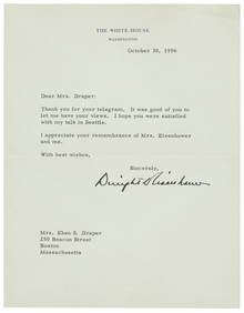
SoldWhite, Charles A, Map of Washington Territory West ofWhite, Charles A, Map of Washington Territory West of the Cascade Mountains. New York: G.W. & C.B. Colton & Co., 1870. Lithographed map on four sheets, 123 x 167 cm, hand-colored. (Some creasing.) OriSee Sold Price
WHITE, Charles A. Map of Washington Territory....Grandiose Map of Washington Territory in 1870 371. [MAP]. WHITE, Charles A. Map of Washington Territory West of the CascSee Sold Price
SoldMap of Washington Territory west of Cascade Mountains,Map of Washington Territory west of Cascade Mountains, comp. by Charles A. White. NY: 1870Statue miles 4 to One (1) inch.Dimensions: 30 1/2" X 20 1/2" and 30 1/4" X 15" in Two (2) sections (maps)Inv.3See Sold Price
SoldRARE Hand colored map by Charles DeSilver c. 1859RARE original hand colored map of California and the territories of Oregon, Washington, Utah and New Mexico, by Charles DeSilver, in frame, circa 1859, image measuring 16.75" xSee Sold Price
SoldDesilver map of California, etc., 1854Title: A New Map of the State of California, the Territories of Oregon, Washington, Utah & New Mexico Author: Desilver, Charles Description: Lithographed map, hand-colored. 38x30 cm. (15x11¾") plus dSee Sold Price
SoldDesilver map of California, etc., 1856Title: A New Map of the State of California, the Territories of Oregon, Washington, Utah & New Mexico Author: Desilver, Charles Description: Lithographed map, hand-colored. 38x30 cm. (15x11¾") plus dSee Sold Price
Desilver map of California, etc., 1856Title: A New Map of the State of California, the Territories of Oregon, Washington, Utah & New Mexico Author: Desilver, Charles Description: Lithographed map, hand-colored. 38x30 cm. (15x11¾") plus dSee Sold Price
Civil War: Virginia and Washington, D.C. Military MapInteresting page featuring a "View of Washington City" and "Military Map of Maryland & Virginia" by Charles Magnus, 8.25 x 10.5, with annotations indicating the bridge into Virginia, the White House,See Sold Price
Civil War: Virginia and Washington, D.C. Military MapInteresting page featuring a "View of Washington City" and "Military Map of Maryland & Virginia" by Charles Magnus, 8.25 x 10.5, with annotations indicating the bridge into Virginia, the White House,See Sold Price
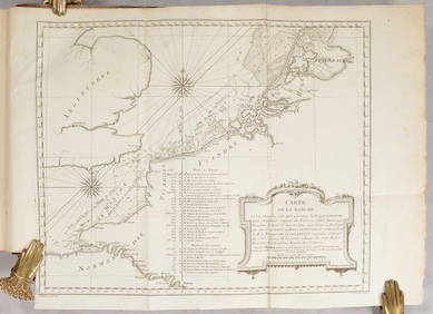
SoldEarly Oregon Trail Map - , ORc1841 This is a 38" x 24" black and white "Map/ Of The/ Oregon Territory/ By The/ U.S. E.X. E.X./ Charles Wilkes Esqr./ Commander/ 1841". The printer`s mark on the lower right corner of the map is mosSee Sold Price
SoldMap of Territory of Idaho by Charles Roeser 1876Territory of Idaho comp. by Charles Roeser. Washington, DC: and NY: Julius Bien, 1876Dimensions: 17 3/4" X 10"Inv.53See Sold Price
Map of Territory of Idaho comp. by Charles Roeser.Territory of Idaho comp. by Charles Roeser. Washington, DC: and NY: Julius Bien, 1876Dimensions: 17 3/4" X 10"Inv.171See Sold Price
Map of Territory of Idaho comp. by Charles Roeser.Territory of Idaho comp. by Charles Roeser. Washington, DC: and NY: Julius Bien, 1876Dimensions: 17 3/4" X 10"Inv.171See Sold Price
SoldU.S. MAP WASHINGTON TERRITORY, ANSON HENRY, 1863"Map of Public Surveys, Washington Territory to accompany Report of Surv: Genl: 1863, Anson G. Henry, Surveyor General, Lith of J. Bien 24 Vesey St, NY", showing positions of Mt. Baker, Gold Mines, OlSee Sold Price
Cram's Washington (territory) MapCram's Washington (territory) Map, Washington (Territory) George F. Cram 1887 Map, 13.5 x 11 in Please note that this lot has a confidential reserve. When you leave a bid in advance of the auction, suSee Sold Price
SoldGLO Map of Washington Territory, ca 1860-61**Originally Listed At $100** Map of a Part of Washington Territory to Accompany the Report of the Surveyor General 1860-61. A very collectible early survey map of the Washington Territory that was coSee Sold Price
SoldMap of Washington Territory, 1859Map: 1859 Washington Territory Map -- Map of a Part of Washington Territory to Accompany the report of the Surveyor General Cartographer: US State Surveys (J Tilton) Year / Place: 1859 Washington MapSee Sold Price
SoldPocket map of Washington Territory 1878Heading: Author: Habersham, Robert A. Title: J.K. Gill & Cos. Map of Washington Ter. Portland Ogn. 1878. Showing all surveys made previous to January 1st 1878. Compiled by Robt. A. Habersham Civil EnSee Sold Price
SoldMap of Washington Territory 1879Title: Washington Territory Author: U.S. State Surveys Description: Color lithographed map. Compiled by C. Roeser from the official records of the General Land Office. Lithographed by Julius Bien. 56xSee Sold Price
1883 Map of Washington TerritoryAuthor: Cram Title: 1883 Map of Washington Territory Medium: Ink on Paper Dimensions: 13.5"X11" Map of Washington territory dated 1883. Engraved and published by George Cram in Chicago. Color coded foSee Sold Price
GLO Map of Washington Territory, ca 1860-61**Originally Listed At $100** Map of a Part of Washington Territory to Accompany the Report of the Surveyor General 1860-61. A very collectible early survey map of the Washington Territory that was coSee Sold Price
GLO Map of Washington Territory, ca 1860-61**Originally Listed At $100** Map of a Part of Washington Territory to Accompany the Report of the Surveyor General 1860-61. A very collectible early survey map of the Washington Territory that was coSee Sold Price
SoldUncommon map of Washington TerritoryHeading: Author: Page, H.R., & Co. Title: Map of Washington Ter. Place Published: Chicago Publisher: Date Published: 1883 Description: Lithographed map, hand-colored. 35.7xSee Sold Price
GLO Map of Washington Territory, ca 1860-61Map of a Part of Washington Territory to Accompany the Report of the Surveyor General 1860-61. A very collectible early survey map of the Washington Territory that was conducted under the supervisionSee Sold Price
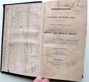
Charles Butler Ancient & Modern Music 1824 1st Edition Scarce MusicLuis Porretta Fine Arts4.3(10)See Sold PriceMar 02, 2024
[ART]. MacLeish, Norman. Exhibition of Negro Artists of Chicago. Washington, DC: Howard UniversityFreeman's | Hindman4.4(1.6k)See Sold PriceFeb 27, 2024
D'Oyly (Calcutta, India) - Government House from St. Andrew's LibraryTrillium Antique Prints & Rare Books4.5(32)See Sold PriceFeb 24, 2024
D'Oyly (Calcutta, India) - Procession of the CurruckpoojaTrillium Antique Prints & Rare Books4.5(32)See Sold PriceFeb 24, 2024


![[ART]. MacLeish, Norman. Exhibition of Negro Artists of Chicago. Washington, DC: Howard University (1 of 3)](https://p1.liveauctioneers.com/197/319238/171468004_1_x.jpg?height=282&quality=70&version=1707520367)