W. & J. MOUNT & T. PAGE: 'A NEW CHART OF THE SEA COASTW. & J. MOUNT & T. PAGE: 'A NEW CHART OF THE SEA COAST OF SCOTLAND WITH THE ISLANDS THEREOF..' CIRCA 1756 hand-coloured map on laid paper -- 19 x 21in. (48 x 53.5cm.)See Sold Price
SoldMount & Page. Charts of Lowestoft & OrfordnessMount (J.) and T. Page. Publishers. A New and Correct Chart of the Sea Coast from Lowestoft to Orford; A New and Correct Chart of the Sea Coast from Orfordness Lights to Prittlewell,2 coastalSee Sold Price
SoldMount (J.) and T. Page. Publishers. A New and CorMount (J.) and T. Page. Publishers. A New and Correct Chart of the Sea Coast from Lowestoft to Orford; A New and Correct Chart of the Sea Coast from Orfordness Lights to Prittlewell,2 coastalSee Sold Price
Sold[SHIP-USED ATLAS] GREAT BRITAIN'S COASTING PILOTIn Two Parts, Being a New and Exact Survey of the Sea-Coast of England and Scotland..., by Captain Greenvile Collins, London: Printed for W. and J. Mount and T. Page, on Tower-Hill, 1758, inscribed 'TSee Sold Price
SoldPortugal & Spain.- (W.J.) Mount & T. Page A Chart ofPortugal & Spain.- Mount (W.J.) & T. Page A Chart of the Sea Coasts of Algrave and Andalusia Between Cape St. Vincent and the Strait of Gibralter and C Spartel, English sea chart of the southern coastSee Sold Price
SoldSpain.- Biscay.- Mount & T. Page (W.J.) A Chart of theSpain.- Biscay.- Mount (W.J.) & T. Page A Chart of the Sea Coasts of Biscay and Gallicia between Cape Machicaca and Cape de Pinas and from Cape de Pinas to Cape de Finisterre, two English sea charts oSee Sold Price
1700s Coast of Portugal and Spain Map, Mount & PageEarly 18th century. A partially hand-colored New Sea Chart of the Coast of Portugal and part of Spain, from Cape Finistere. By the notable Mount & Page mao company. Fair condition. Bottom rightSee Sold Price
SoldMount (J.) and T. Page. Publishers. A group of 16Mount (J.) and T. Page. Publishers. A group of 16 marine charts,including the North Sea, the Norwegian sea, with charts of the coast of Denmark, Norway, and others, engraved maps, each c. 425See Sold Price
SoldFrance.- Biscay.- Mount & T. Page (W.J.) The Sea CoastsFrance.- Biscay.- Mount (W.J.) & T. Page The Sea Coasts of France from Olone to Cape Machiacaca in Biscay, English sea chart of the Bay of Biscay, with large inset chart of the Bordeaux river, embelliSee Sold Price
France.- Brittany.- Mount (W.J.) & T. Page The SeaFrance.- Brittany.- Mount (W.J.) & T. Page The Sea Coast of France from Ushent to Olone, English sea chart of Brittany with inset maps of Brest harbour, and another of the mouth of the Loire from theSee Sold Price
SoldIreland.- Mount (W.J.) & T. Page. A Chart of the CoastsIreland.- Mount (W.J.) & T. Page. A Chart of the Coasts of Ireland and Part of England, detailed chart of all Ireland with the Irish Sea and western approaches from Scilly to the Severn Estuary and WaSee Sold Price
Portugal.- Algarve.- Mount (W.J.) & T. Page A Chart ofPortugal.- Algarve.- Mount (W.J.) & T. Page A Chart of part of the Coasts of Gallisia and Portugall, two English sea charts on one sheet showing from Cape Finisterre to Peniche and the the Berlengas aSee Sold Price
Chart of the South Sea 1721Title: A Generall Chart of the South Sea from the River of Plate to Dampiers Streights on ye Coast of New Guinea Author: Mount, Richard & Thomas Page Description: Copper-engraved chart. 44x58 cm. (17�See Sold Price
Sold1833 J W Norie “New Chart of the Coast of America1833 J W Norie “New Chart of the Coast of America from New York & Philadelphia to the Strait or gulf of Florida†J Stephenson, engraver (rough as found condition, tears & creases, losses, maSee Sold Price
Mount & Page: Antique North Sea Coast Chart, 1771TITLE/CONTENT OF MAP: 'A correct chart of the sea coasts of England, Flanders and Holland. Shewing the sands, shoals, rocks and dangers, the bays, harbours, roads, buoys, beacons & seamarks on the saiSee Sold Price
Mount (J.) and T. Page. - A New and Correct Chart ofnorth oriented to the right, England, Scotland and Ireland with inset coats-of-arms, decorative title cartouche upper right, compass roses and rhum lines, engraved map with hand-colouring, 450 x 560mmSee Sold Price
North Sea Coast ChartNORTH SEA coast chart. East Anglia Holland Flanders. MOUNT/PAGE/COLLINS 1771 map Size: Approx 46.0 x 57.5cm, 18 x 22.5 inches (Large); Please note that this is a folding map. Please note that this lotSee Sold Price
SoldMount & Page A Chart of ye Coast of BarbaryMount (J.) and T. Page. Publishers. A Chart of ye Coast of Barbary from Cape Geer to Cape Bajadore,with A Chart of ye Coast of Barbary from C. Bajadore to the Golfe of St. Anne, two charts onSee Sold Price
SoldMount (J.) and T. Page. Publishers. A Chart of yeMount (J.) and T. Page. Publishers. A Chart of ye Coast of Barbary from Cape Geer to Cape Bajadore,with A Chart of ye Coast of Barbary from C. Bajadore to the Golfe of St. Anne, two charts onSee Sold Price
Mount (J.) and T. Page. Publishers. A Chart of yeMount (J.) and T. Page. Publishers. A Chart of ye Coast of Barbary from Cape Geer to Cape Bajadore,with A Chart of ye Coast of Barbary from C. Bajadore to the Golfe of St. Anne, two charts onSee Sold Price
SoldMap of West Indies from Mercator 1773"A new general chart for the West Indies of E Wright's projection on Mercator's chart," London: J. Mount & T. Page, ca. 1773. From "The English Pilot. The Fourth Book describing the West India NavigatSee Sold Price
Mount & Page Map of the Atlantic, 1723MOUNT & PAGE. A General Chart of the Western Ocean. Engraved map. London: W. Mount & T. Page, c. 1723-1773. 18 7/8” x 23 1/2” sheet. Handsome and scarce sea chart of the North Atlantic covering thSee Sold Price
Sold(Maritime), Colson, Nathaniel, The Mariner's New K(Maritime), Colson, Nathaniel, The Mariner's New Kalendar, London: W. and J. Mount and T. Page, 1748, later light brown calf, small 8vo, (seventeen repaired leaves with most text intact, some minor teSee Sold Price
Thornton, J.: Chart of the Caribe Islands Map 1730Map: A Chart of the Caribe Islands, Puerto Rico/ Lesser Antilles Publishing: Thornton, J., Mount, W.& J., Page, T.: London Date: 1730 Size: 16.75 x 20.75 inches The primary, printed chart used by EnglSee Sold Price
BOTH TITLE PAGES OF COLLINS" COASTAL SURVEY, 1776, IN MATCHING FRAMESThomaston Place Auction Galleries4.4(394)See Sold PriceFeb 24, 2024
Capobianco "The Severed Head of..." Oil on CanvasAuctions at Showplace4.6(744)See Sold PriceMar 03, 2024
CHART "LONG ISLAND SOUND FROM NEW YORK TO MONTOCK POINT ..." New York, 1830 21" x 77" sight. FramedEldred's4.7(423)See Sold PriceFeb 27, 2024
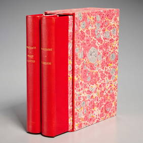
[OCCULT]. BLAVATSKY, H.P. (1831 – 91). Isis Unveiled: A Mas...Potter & Potter Auctions4.6(550)See Sold PriceFeb 24, 2024
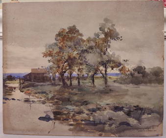
J Francis Murphy W/C New England Landscape PaintingHeritage Gallery Auctions4.4(63)See Sold PriceMar 10, 2024
An ornate pair of juvenile 'Dobby' horse carousel mounts by C J Spooner,Sworders Fine Art Auctioneers4.4(30)See Sold PriceMar 07, 2024
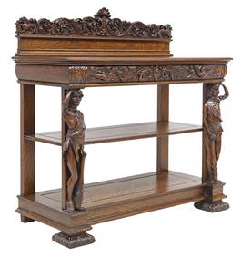
R.J. HORNER (ATTRIB.) AMERICAN QUARTER SAWN OAK SERVERAustin Auction Gallery4.7(1.2k)See Sold PriceFeb 25, 2024
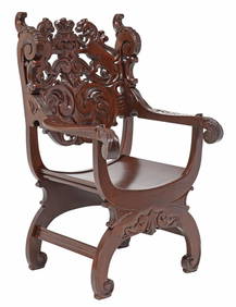
R.J. HORNER (ATTRIB.) RENAISSANCE STYLE CARVED MAHOGANY CURULE CHAIRAustin Auction Gallery4.7(1.2k)See Sold PriceFeb 25, 2024
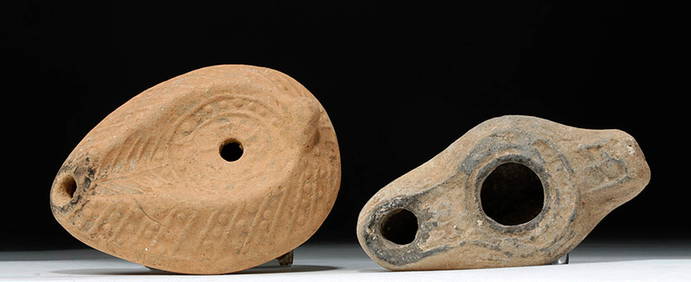
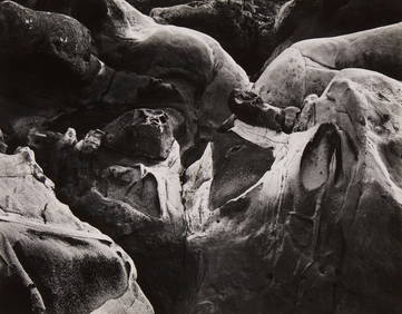
Edward Weston (1886-1958), "Sandstone Erosion, Point Lobos," 1942, Gelatin silver print on paperJohn Moran Auctioneers, Inc.4.7(463)See Sold PriceFeb 27, 2024
Edward Weston (1886-1958), "Rock Erosion, Point Lobos," 1938, Gelatin silver print on paper mountedJohn Moran Auctioneers, Inc.4.7(463)See Sold PriceFeb 27, 2024
4 Books on Birds and Animals HardbacksNorth American Artifact Auctions4.7(201)See Sold PriceApr 20, 2024
Domenick Capobianco Abstract Ocean Oil on CanvasAuctions at Showplace4.6(744)See Sold PriceMar 17, 2024
[ENSLAVEMENT & ABOLITION]. A group of photographs and other items related to abolitionist figuresFreeman's | Hindman4.4(1.6k)See Sold PriceFeb 27, 2024
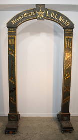
19Th C. Freemason Archway In Original PaintRalph Fontaine Heritage Auctions Inc.4.7(236)See Sold PriceFeb 25, 2024
1780 BIBLE in DUTCH ILLUSTRATED w/ 38 ENGRAVINGS antique OLD & NEW TESTAMENTJasper524.5(9.9k)See Sold PriceFeb 27, 2024
South Namibia coast. Walvis Bay-Orange River ADMIRALTY sea chart 1881 (1954) mapJasper524.5(9.9k)See Sold PriceFeb 28, 2024
America's Heroes & Ronald Reagan The First Four Years HardcoversRapid Estate Liquidators and Auction Gallery4.5(1.1k)See Sold PriceFeb 29, 2024
Vintage Roy Norton The Plunderer HardcoverRapid Estate Liquidators and Auction Gallery4.5(1.1k)See Sold PriceMar 01, 2024


![[SHIP-USED ATLAS] GREAT BRITAIN'S COASTING PILOT (1 of 14)](https://p1.liveauctioneers.com/522/145506/73550360_1_x.jpg?height=282&quality=70&version=1562377940)


![[OCCULT]. BLAVATSKY, H.P. (1831 – 91). Isis Unveiled: A Mas... (1 of 3)](https://p1.liveauctioneers.com/928/317913/170625569_1_x.jpg?height=282&quality=70&version=1706650066)


![[ENSLAVEMENT & ABOLITION]. A group of photographs and other items related to abolitionist figures (1 of 3)](https://p1.liveauctioneers.com/197/319238/171468086_1_x.jpg?height=282&quality=70&version=1707520367)