ATLAS of ANTIENT GEOGRAPHY by SAMUEL BUTLER 1843John McInnis Auctioneers,LLC4.6(502)See Sold PriceFeb 24, 2024
18TH C. ANTIQUE MAP: FRENCH & INDIAN WAR, FRAMEDThomaston Place Auction Galleries4.4(386)See Sold PriceFeb 24, 2024
Rand McNally Railroad Map Cabinet w/ 21 Railroad MapsRail & Road Auctions4.6(165)See Sold PriceMar 08, 2024
Keith Haring - Ink on New York Map, Best Buddies, Inscribed, Signed, and DatedSapphire Auction Gallery4(67)See Sold PriceMar 02, 2024
LATE 17TH C. FRENCH MAP OF THE NEW WORLD BY ALEXIS-HUBERT JAILLOT (1632-1712)Thomaston Place Auction Galleries4.4(386)See Sold PriceFeb 24, 2024
Central Railroad of New Jersey Map of Sandy Hook Route-ca. 1903JM Hobby Supply and Railroad Artifact Auctions4.4(126)See Sold PriceFeb 24, 2024
Lot of Six Mixed Atlas Box Cars-HO Scale-New in BoxJM Hobby Supply and Railroad Artifact Auctions4.4(126)See Sold PriceFeb 25, 2024
Rand McNally/Santa Fe Railroad Map of Iowa-1912JM Hobby Supply and Railroad Artifact Auctions4.4(126)See Sold PriceFeb 24, 2024
NICOLAES VISSCHER (NETHERLANDS, 1618-1709) MAP OF THE NEW WORLDThomaston Place Auction Galleries4.4(386)See Sold PriceFeb 24, 2024
17TH C. WORLD MAP BY NICOLAES VISSCHER (NETHERLANDS, 1618-1709)Thomaston Place Auction Galleries4.4(386)See Sold PriceFeb 24, 2024
Lot of Six Mixed Atlas Cabooses-HO Scale-New in BoxJM Hobby Supply and Railroad Artifact Auctions4.4(126)See Sold PriceFeb 25, 2024
SoldVIRGINIA / WASHINGTON, D.C. MAP / PRINTVIRGINIA / WASHINGTON, D.C. MAP / PRINT, hand-colored, having two images, the upper being a panoramic view of Washington, D.C. with the Capitol Building in the foreground, and the lower image being aSee Sold Price
SoldFour Washington D.C. Related Maps & Prints ca. 19th CenturyGroup of four Washington D.C. related maps & prints, ca. mid to late 19th century. Frame size of "Map of Washington. District of Columbia." are 10 1/2" H x 11 1/2" W x 3/8" D.See Sold Price
Civil War: Virginia and Washington, D.C. Military MapInteresting page featuring a "View of Washington City" and "Military Map of Maryland & Virginia" by Charles Magnus, 8.25 x 10.5, with annotations indicating the bridge into Virginia, the White House,See Sold Price
Civil War: Virginia and Washington, D.C. Military MapInteresting page featuring a "View of Washington City" and "Military Map of Maryland & Virginia" by Charles Magnus, 8.25 x 10.5, with annotations indicating the bridge into Virginia, the White House,See Sold Price
1831 Hinton Map of Virginia, Maryland, Delaware andTitle: 1831 Hinton Map of Virginia, Maryland, Delaware and Washington DC -- Map of the States of Virginia, and Maryland Cartographer: J Hinton Year / Place: 1831, London Map Dimension (in.): 9.7 X 15.See Sold Price
1831 Hinton Map of Virginia, Maryland, Delaware andTitle: 1831 Hinton Map of Virginia, Maryland, Delaware and Washington DC -- Map of the States of Virginia, and Maryland Cartographer: J Hinton Year / Place: 1831, London Map Dimension (in.): 9.7 X 15.See Sold Price
SoldHand-Inked Civil War Field Map of Northern Virginia,Civil War-period manuscript map on linen, in black/brown and blue ink, 31 x 37 in., depicting Northern Virginia and Washington, DC, ca 1862. The map key at lower right indicates what represents a "ComSee Sold Price
SoldMaps of MD, DE, VA & D.C. Mid 19th century.A group of maps of Maryland, Delaware, Virginia and Washington D.C. ++ A Johnson & Ward map of Delaware and Maryland. 1864/New York. Maker: Alvin J. Johnson & H.C. Ward. Including vignettes of the PosSee Sold Price
SoldCivil War Map of Northern Virginia and Washington, D.C.Attractive circa 1892 color Civil War map entitled “Surveys for Military Defenses Map of North Eastern Virginia and Vicinity of Washington,” 27.75 x 17, issued as Plate VII, Sheet 1, and pSee Sold Price
Washington DC Map of Smithsonian Museum SerigraphReference #: ULXX1873 Artist Name: Unknown Title: Washington DC Area Map of the Smithsonian Museum Medium: Serigraph Edition Size: Unknown Year: Unknown Paper Size: 48.5 x 32.5 in. Image Size: 33.5 xSee Sold Price
MTA Washington DC Area Map SerigraphReference #: ULXX1870 Artist Last Name: MTA Artist First Name: Washington Title: Washington DC Area Map Medium: Serigraph Paper Height: 48.5 inches Paper Size Width: 33.3 inches Image Height: 33.5 incSee Sold Price
Washington DC Area Map SerigraphReference #: ULXX1870 Artist Name: Unknown Title: Washington DC Area Map Medium: Serigraph Edition Size: Unknown Year: Unknown Paper Size: 48.5 x 33.3 inches Image Size: 33.5 x 33.5 inches Condition:See Sold Price
Washington DC Area Map SerigraphReference #: ULXX1870 Artist Name: Unknown Title: Washington DC Area Map Medium: Serigraph Edition Size: Unknown Year: Unknown Paper Size: 48.5 x 33.3 inches Image Size: 33.5 x 33.5 inches Condition:See Sold Price
Washington DC Area Map SerigraphReference #: ULXX1870 Artist Name: Unknown Title: Washington DC Area Map Medium: Serigraph Edition Size: Unknown Year: Unknown Paper Size: 48.5 x 33.3 inches Image Size: 33.5 x 33.5 inches Condition:See Sold Price
Washington DC Area Map SerigraphReference #: ULXX1870 Artist Name: Unknown Title: Washington DC Area Map Medium: Serigraph Edition Size: Unknown Year: Unknown Paper Size: 48.5 x 33.3 inches Image Size: 33.5 x 33.5 inches Condition:See Sold Price
Washington DC Area Map SerigraphReference #: ULXX1870 Artist Name: Unknown Title: Washington DC Area Map Medium: Serigraph Edition Size: Unknown Year: Unknown Paper Size: 48.5 x 33.3 inches Image Size: 33.5 x 33.5 inches Condition:See Sold Price
Washington DC Area Map SerigraphReference #: ULXX1870 Artist Name: Unknown Title: Washington DC Area Map Medium: Serigraph Edition Size: Unknown Year: Unknown Paper Size: 48.5 x 33.3 in. Image Size: 33.5 x 33.5 in. Condition: A-: NeSee Sold Price
MTA Washington DC White House Serigraph MapReference #: ULXX1872 Artist Last Name: MTA Artist First Name: Washington Title: Washington DC Area Map-The White House Medium: Serigraph Paper Height: 48.5 inches Paper Size Width: 33.25 inches ImageSee Sold Price
Washington DC Area Map-The White House SerigraphReference #: ULXX1872 Artist Name: Unknown Title: Washington DC Area Map-The White House Medium: Serigraph Edition Size: Unknown Year: Unknown Paper Size: 48.5 x 33.25 inches Image Size: 33.5 x 33.25See Sold Price
Washington DC Area Map-The White House SerigraphReference #: ULXX1872 Artist Name: Unknown Title: Washington DC Area Map-The White House Medium: Serigraph Edition Size: Unknown Year: Unknown Paper Size: 48.5 x 33.25 inches Image Size: 33.5 x 33.25See Sold Price
Washington DC Area Map-The Pentagon SerigraphReference #: ULXX1874 Artist Name: Unknown Title: Washington DC Area Map-The Pentagon Medium: Serigraph Edition Size: Unknown Year: Unknown Paper Size: 48.5 x 33.25 inches Image Size: 33.5 x 33.25 incSee Sold Price
Washington DC Area Map-The Pentagon SerigraphReference #: ULXX1874 Artist Name: Unknown Title: Washington DC Area Map-The Pentagon Medium: Serigraph Edition Size: Unknown Year: Unknown Paper Size: 48.5 x 33.25 inches Image Size: 33.5 x 33.25 incSee Sold Price
Washington DC Area Map-The Pentagon SerigraphReference #: ULXX1874 Artist Name: Unknown Title: Washington DC Area Map-The Pentagon Medium: Serigraph Edition Size: Unknown Year: Unknown Paper Size: 48.5 x 33.25 inches Image Size: 33.5 x 33.25 incSee Sold Price
Washington DC Area Map-The Pentagon SerigraphReference #: ULXX1874 Artist Name: Unknown Title: Washington DC Area Map-The Pentagon Medium: Serigraph Edition Size: Unknown Year: Unknown Paper Size: 48.5 x 33.25 inches Image Size: 33.5 x 33.25 incSee Sold Price
African American History, Martin Luther King SpeechConnoisseur Auctions4(333)See Sold PriceFeb 24, 2024
African American History, Washington DC Family Photo PrintConnoisseur Auctions4(333)See Sold PriceFeb 24, 2024
African American History, Washington DC Family Photo PrintConnoisseur Auctions4(333)See Sold PriceMar 02, 2024
G. Harvey, Gentle Nation, Washington D.C., CapitalLotus International Auctions, LLC4.6(153)See Sold PriceMar 03, 2024
FORT LARAMIE NATIONAL MONUMENT, WYOMING 1954North American Artifact Auctions4.6(182)See Sold PriceApr 20, 2024
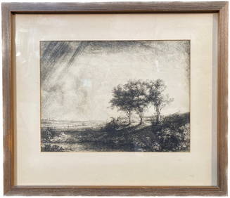
REMBRANDT VAN RIJN (1606-1669) LITHOGRAPH TITLED THE THREE TREES, 13IN x 15INThe Rug Life4.3(12)See Sold PriceMar 07, 2024
EDVARD MUNCH (1863-1944) ORIGINAL NATIONAL GALLERY EXHIBIT POSTER FOR HIS MASTER PRINTS, 32IN x 41INThe Rug Life4.3(12)See Sold PriceMar 07, 2024
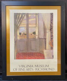
ORIGINAL HENRI MATISSE (1869-1954) VIRGINIA MUSEUM OF FINE ART EXHIBITION POSTER, 31IN x 38IN (79cmThe Rug Life4.3(12)See Sold PriceMar 07, 2024
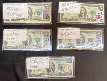
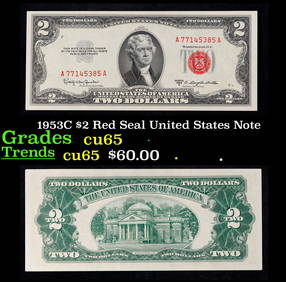
TEN $2 BILLS STAMPED JULY 4, 1976 FROM RICHMOND, VA. 6 ARE CONSECUTIVELY NUMBEREDThe Rug Life4.3(12)See Sold PriceMar 07, 2024
Mitchell - Map of the City of Washington (Washington, DC)Trillium Antique Prints & Rare Books4.5(30)See Sold PriceFeb 24, 2024
Chicago Bulls vs. Washington Bullets Dec. 14.1991 (Michael Jordan 29 points) Ticket Stub Capital3 Kings Auction4.3(194)See Sold PriceFeb 27, 2024
CLAUDE MONET (1840-1926) PRINT ON CANVAS TITLED THE JAPANESE FOOT BRIDGE, 20.5IN x 25IN (52cm xThe Rug Life4.3(12)See Sold PriceMar 07, 2024
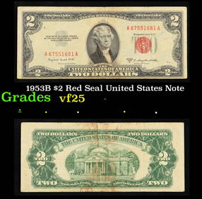
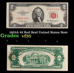
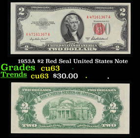
1953A $2 Red Seal United States Note Grades Select CUKey Date Coins4.2(1.2k)See Sold PriceFeb 28, 2024