SoldVery early hand colored map of Belgium dated 1579 -Very early hand colored map of Belgium dated 1579 - 16x21See Sold Price
SoldLot of 2 Early Hand Colored Engraved MapsLot of two early hand colored engraved maps, to include: "Andegaver Sium Ditionis Vera et Integra Descripto," dated 1579, map of Anjou, France, 13 3/4" h x 18 3/8" w (view), 19" h x 23 5/8" w (frame)See Sold Price
SoldFramed Hand Colored Map of Belgium dated 1748Framed hand colored map of Belgium dated 1748, author Tobia Mayero. Framed, not examined out of frame. Only after the final defeat of Napoleon, was the name of the Seven Provinces changed to the NetheSee Sold Price
SoldEarly Hand Colored Map of FranceEarly hand colored map of France dated 1628 covering the provinces Orange and Avignon 15.75"H x 20"WSee Sold Price
EARLY HANDCOLORED MAP OF AMERICA BY HOMAEARLY HANDCOLORED MAP OF AMERICA BY HOMANN. Dated "1687" and titled "Mississippi" by "aIo. Bapt. Homanno, Norimberge". Good color and condition with foxing. Taped at the corners to a backing. 21" x 24See Sold Price
EARLY HANDCOLORED FRENCH MAP OF THE AMEEARLY HANDCOLORED FRENCH MAP OF THE AMERICAS. Dated "1722" and titled "Carte d' Amerique, Par Guillaume Delisle, Paris". Engraving with green and red coloring along the coastline and rivers. Minor staSee Sold Price
SoldEarly Abraham Ortelius hand-colored 1584 map of thEarly Abraham Ortelius hand-colored 1584 map of the Low Countries (Belgium) with four ornate cartouches and a compass rose, showing the English Chanel and part of Britain. 15.75”h.x19.5”w.See Sold Price
1579 Cremae Diotionis Descriptio Agricremonensis TypusBy: Abraham Ortelius Date: 1579 (dated) Antwerp Dimensions: 13.5 x 19.5 inches (34.3 cm x 50 cm) This breathtaking authentic, antique hand-colored map was published by Abraham Ortelius and based on anSee Sold Price
1726 Map of BelgiumTitle: 1726 Map of Belgium Author: Weigelen Medium: Ink on Paper Dimensions: 20"X16" Map of Belgium dated 1726. Engraved by Chritopher Weigelen in Nuremberg. Hand colored. Elaborate cartouche upper leSee Sold Price
Map of BelgiumTitle: Map of Belgium Artist: Weigelen Medium:Paper Dimensions: 20" X 16" Description: Map of Belgium dated 1726. Engraved by Christopher Weigelen in Nuremberg. Hand colored. Elaborate cartouche upperSee Sold Price
1726 Map of BelgiumAuthor: Weigelen Title: 1726 Map of Belgium Medium: Ink on Paper Dimensions: 20"X16" Map of Belgium dated 1726. Engraved by Christopher Weigelen in Nuremberg. Hand colored. Elaborate cartouche upper lSee Sold Price
Sold(1781-Dated) New York Rev War Map Reprint c 1870Historic Maps Rare Early New York Revolutionary War Era Map Reprint (1781-Dated) New York Revolutionary War Map, c. 1870 Early Hand-colored Reprint, Placed Upon A 20” x 12” Wooden Presentation MouSee Sold Price
1579 dated MAP of NAMUR BELGIUM antique 16 by 20.5"1579 dated MAP of NAMUR, BELGIUM Titled: Namurcum. Early map of the old county of Namur with beautiful cartouches, with coat of arms and compass rose. German gothic text on verso. This map is from: 'TSee Sold Price
1778 World Atlas of 52 Maps by Robert De VaugondyAmerican Revolution 1778 Robert De Vaugondy's World Atlas With Fifty-two Handcolored Dated Maps the World Divided by Religions 1778-Dated Revolutionary War Period, Hand-Colored Engraved "World Atlas"See Sold Price
SoldDOUBLE-PAGE ENGRAVED AND HAND-COLORED EARLY MAPof Flandria or current day Belgium, likely that this map is Ortelius Map #75, frayed edges and repaired tears, 15x20in.See Sold Price
Early Copy of Engraved Map of Africa by Willem BlaeuAn early hand-colored copy of a copper engraved map of Africa by Dutch cartographer Willem Janszoon Blaeu (1571-1638). This map is signed and dated 1631 on the lower left. It is presented in a woodenSee Sold Price
SoldTHREE ANTIQUE FRAMED MAPSincluding a double page, hand-colored map of Norlingen Germany dated 1549, a double page uncolored engraving of Albany NY dated 1794, and an early hand colored etching of Franconia, Germany, likely c.See Sold Price
Sold1867 Impressive Colorful Map of the New York AreaHistoric Maps Colorful Hand-colored 1867 Folding Map of New York 1867-Dated, Hand-colored Map, 40 MILES AROUND NEW YORK by H.H. Lloyd, Very Fine. Impressive Hand-colored Pocket Map measuring 29" x 27"See Sold Price
Sold1847 Hand-Colored Map: A New Map of VIRGINIA...Historic Maps 1847 “A New Map of Virginia...” by S. Augustus Mitchell 1847-Dated, Hand-Colored Map titled “A New Map of VIRGINIA...”, Published by S. Augustus Mitchell, Choice Crisp ExtremelySee Sold Price
1867 Impressive Colorful Map of the New York AreaHistoric Maps Colorful Hand-colored 1867 Folding Map of New York 1867-Dated, Hand-colored Map, 40 MILES AROUND NEW YORK by H.H. Lloyd, Very Fine. Impressive Hand-colored Pocket Map measuring 29" x 27"See Sold Price
Sold1797 A Map of America, or The New World, FadenHistoric Maps 1797 “A Map of America, or The New World” by Faden April 12, 1797-Dated, Hand-Colored Map, “A Map of America, or The New World,” Published by W. Faden, Wm. Palmer, sculptor, LondSee Sold Price
Sold1745 Historic Hand-Colored Map of the Holy LandHistoric Maps 1745 Historic Hand-Colored Map of the Holy Land Divided According to the Twelve Tribes of Israel with Inset Map 1745-Dated Historic Hand-Colored Map of the Holy Land titled, “Carte deSee Sold Price
1867 Impressive Colorful Map of the New York AreaHistoric Maps Impressive Colorful 1867 Folding Map of New York 1867-Dated, Impressive Hand-colored Map, 40 MILES AROUND NEW YORK by H.H. Lloyd, Very Fine. Impressive Hand-colored Pocket Map measuringSee Sold Price
Sold1745 Historic Hand-Colored Map of the Holy LandHistoric Maps 1745 Hand-Colored Map of the Holy Land Divided Among the Twelve Tribes of Israel with Inset Map 1745-Dated Historic Hand-Colored Map of the Holy Land titled, "Carte de la terre des HebreSee Sold Price
EARLY 18TH C. DUTCH CHART OF PACIFIC OCEAN BY FREDERIK DE WIT (1629-1706) WITH CALIFORNIA AS ANThomaston Place Auction Galleries4.4(386)See Sold PriceFeb 24, 2024
EARLY 18TH C. MAP OF ITALY, FRAMEDThomaston Place Auction Galleries4.4(386)See Sold PriceFeb 24, 2024
Early 1900's Railway Service Map, Illinois, Ohio, Indiana, Kentucky, TennesseeConnoisseur Auctions4(333)See Sold PriceFeb 24, 2024
An early Dutch hand colored engraving map by Georg Balthasar Probst (1732-1801)Ostantix Auctions4.4(10)See Sold PriceFeb 27, 2024
Hand Colored Map of the city of Amsterdam 1720Global Auctions Company4.3(36)See Sold PriceMar 03, 2024
Hand Colored Engraved Map of Europe, Jean Baptiste Bourguignon Anville 1754Global Auctions Company4.3(36)See Sold PriceMar 03, 2024
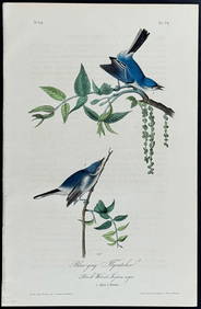
Audubon - Blue-grey Flycatcher. 70Trillium Antique Prints & Rare Books4.5(30)See Sold PriceFeb 24, 2024
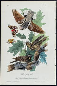
Audubon - Chuck-will's Widow. 41Trillium Antique Prints & Rare Books4.5(30)See Sold PriceFeb 24, 2024
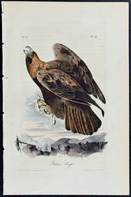
Audubon - Common Osprey Fish Hawk. 15Trillium Antique Prints & Rare Books4.5(30)See Sold PriceFeb 24, 2024
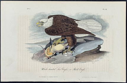
Audubon - White-headed Sea Eagle or Bald Eagle. 14Trillium Antique Prints & Rare Books4.5(30)See Sold PriceFeb 24, 2024
Audubon - Little Screech Owl. 40Trillium Antique Prints & Rare Books4.5(30)See Sold PriceFeb 24, 2024