EARLY HANDCOLORED FRENCH MAP OF THE AMEEARLY HANDCOLORED FRENCH MAP OF THE AMERICAS. Dated "1722" and titled "Carte d' Amerique, Par Guillaume Delisle, Paris". Engraving with green and red coloring along the coastline and rivers. Minor staSee Sold Price
Sold2 Early French Hand Colored Engraved Maps2 Early French Hand Colored Engraved Maps. 1) Canada IIe. Feuille, Plate No. XXXV, B 32. Detailed map of eastern Canada, US and Louisiana territory, c.1776; has a vertical crease through the center. SSee Sold Price
EARLY FRENCH MAP OF THE NORTH PACIFICEarly hand-colored map of the North Pacific, 15 1/4" x 11 3/4", printed in French circa 1779-1780 by "Dupuis". The map depicts the coast of Asia from southern China to the Kamchatka Peninsula, the JapSee Sold Price
SoldThree maps, late 18th-early 19th centuryThree mapslate 18th-early 19th centuryComprising a French hand-colored copperplate map of Virginia, 1760-1762; a map of the United States, 1719, by H.A. Chatelain, Amsterdam; and a map of Delaware, 18See Sold Price
SoldAntique French Map of St. AugustineAntique French Map of St. Augustine, "Plan de la Ville et Port de St. Augustin", late 18th/early 19th c., hand-colored engraved map, sight 8 1/2 in. x 12 in., framed. Provenance: Estate of Faith K. TiSee Sold Price
Sold18TH CENTURY FRENCH COLONIAL / EARLY UNITED STATES MAP18TH CENTURY FRENCH COLONIAL / EARLY UNITED STATES MAP hand-colored, depicting French and English possessions in North America, with the "ETATS UNIS" or United States included, text panels flanking thSee Sold Price
SoldTWO ANTIQUE FRENCH HAND-COLORED ENGRAVED MAPSboth depicting early Catholic Dioceses, one of Sarlat, the other Toulouse, largest 18x26in.See Sold Price
SoldEARLY MAP OF PATAGONIA AND THE STRAIT OF MAGELLANEarly hand-colored, copperplate-engraved map, 20 3/4' x 25 1/2', a depiction of southern South America, including modern Uruguay, Paraguay, Argentina and Chile. The map was created by French cartograpSee Sold Price
Sold3 Items: Partie des Etats_Unis + 2 Maps.[Carribean/Bermuda/Gulf of Mexico]. 3 Items. Early hand-colored outline. ++ Partie Des Etats_Unis. Consists of 2 columns of French text, with a small lithographed map of northeastern North Carolina atSee Sold Price
SoldEARLY FRENCH MAP OF NEW ENGLANDHand-colored. Ca 1750-1760. Map in French. Map 14 1/2 x 12 1/2 inches. Fold marks and water stains. Overall 21 inches x 19 inches. Stains and cut down.See Sold Price
Soldc. 1785, French Map of North AmericaMapsHand-colored map of North America c. 1785, French Map of North America Printed in Holland, Very Fine. This detailed 9.25” x 12” hand-colored map has been matted to an overall size of 1See Sold Price
Soldc. 1785, French Map of North AmericaMapsHand-colored map of North America c. 1785, French Map of North America Printed in Holland, Very Fine. This detailed 9.25" x 12" hand-colored map has been matted to an overall size of 16&See Sold Price
Soldc. 1785, French Map of North AmericaMapsHand-colored map of North America c. 1785, French Map of North America Printed in Holland, Very Fine. This detailed 9.25” x 12” hand-colored map has been matted to an overall size of 1See Sold Price
SoldEARLY 18TH CENTURY L'ISLE FRENCH MAPL'ISLE, Guillaume de, (1675-1726): Early 18th century map of Diocese de Toul, France. Hand colored outlines, shows Roman roads and camps, battle lines, modern roads, and places in French and Latin. SiSee Sold Price
Sold1833 FRENCH MAP OF NORTH AMERICA BY LORRAIN124. 1833 MAP OF NORTH AMERICA Splendid early 19th century map by N. Lorrain, Pere, 14"x20", Paris, 1833. Hand colored copper plate engraving dividing what is now the western United States with MexicoSee Sold Price
French Map of U.S. & Antilles c.1805Title: Etats Unis et Grandes Antilles Author: Chamouin, Jean Baptiste Marie Description: Copper-engraved map, hand-colored in outline. 29.5x22.2 cm. (11½x8½").Early nineteenth century map of the UniSee Sold Price
SoldEARLY FRENCH MAPS OF VIRGINIA AND MARYLAND, LOT OF TWOEARLY FRENCH MAPS OF VIRGINIA AND MARYLAND, LOT OF TWO hand-colored, the first captioned "der Jungfrauen Landt / Fig. 15", with title in upper proper right corner "VIRGINIE", showing the Chesapeake BaSee Sold Price
Sold1758 Carte De La Louisiana, Maryland, Virginie..Colonial America 1758 “Carte De La Louisiana, Maryland, Virginie, Caroline, Georgie, avec une partie de la Floride.” Covens & Mortier 1758-Dated French & Indian War, Hand-Colored Map of the SoutheSee Sold Price
Sold1750s World Globe Map Explorers’ Routes + DatesHistoric Maps 1750s French World Map with Explorers’ Routes & Dates c. 1750, Hand-Colored World Map in Double Hemisphere, “Mappe Monde ou Description du Globe Terrestre,” by Hendrik de Leth, VerSee Sold Price
Sold1750s World Globe Map Explorers’ Routes + DatesHistoric Maps 1750s French World Map with Explorers’ Routes & Dates c. 1750, Hand-Colored World Map in Double Hemisphere, “Mappe Monde ou Description du Globe Terrestre,” by Hendrik de Leth, VerSee Sold Price
Sold1750s World Globe Map Explorers’ Routes + DatesHistoric Maps 1750s French World Map with Explorers’ Routes & Dates c. 1750, Hand-Colored World Map in Double Hemisphere, “Mappe Monde ou Description du Globe Terrestre,” by Hendrik de Leth, VerSee Sold Price
Sold1750s World Globe Map Explorers Routes + DatesHistoric Maps 1750s French World Map with Explorers' Routes & Dates c. 1750, Hand-Colored World Map in Double Hemisphere, "Mappe Monde ou Description du Globe Terrestre," by Hendrik de Leth, Very RareSee Sold Price
French & indian War MapMap of North America from French & Indian War 1760, "PARTIE DU NORD DE L'AMERIQUE..." [NORTH AMERICA], by M. Bonne, Choice Extremely Fine. 12.25" x 9.25" handcolored engraving, with 1-2" margins on leSee Sold Price
LATE 17TH C. FRENCH MAP OF THE NEW WORLD BY ALEXIS-HUBERT JAILLOT (1632-1712)Thomaston Place Auction Galleries4.4(386)See Sold PriceFeb 24, 2024
EARLY 18TH C. DUTCH CHART OF PACIFIC OCEAN BY FREDERIK DE WIT (1629-1706) WITH CALIFORNIA AS ANThomaston Place Auction Galleries4.4(386)See Sold PriceFeb 24, 2024
EARLY 18TH C. MAP OF ITALY, FRAMEDThomaston Place Auction Galleries4.4(386)See Sold PriceFeb 24, 2024
18TH C. ANTIQUE MAP: FRENCH & INDIAN WAR, FRAMEDThomaston Place Auction Galleries4.4(386)See Sold PriceFeb 24, 2024
Early 1900's Railway Service Map, Illinois, Ohio, Indiana, Kentucky, TennesseeConnoisseur Auctions4(333)See Sold PriceFeb 24, 2024
An early Dutch hand colored engraving map by Georg Balthasar Probst (1732-1801)Ostantix Auctions4.4(10)See Sold PriceFeb 27, 2024
Willem Blaeu, Etc. 17th C. Antiquarian Maps, 2Auctions at Showplace4.5(726)See Sold PriceMar 17, 2024
Battle of the Nile: Disposition of the English & French Fleets, at the Commencement of the Action,Trillium Antique Prints & Rare Books4.5(30)See Sold PriceFeb 24, 2024
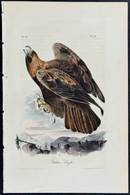
Audubon - Common Osprey Fish Hawk. 15Trillium Antique Prints & Rare Books4.5(30)See Sold PriceFeb 24, 2024
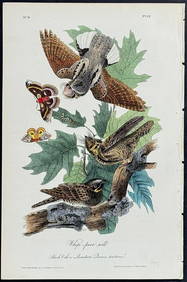
Catesby, Folio - Red Bellied Woodpecker & Hairy Woodpecker with Black Oak. 1-19Trillium Antique Prints & Rare Books4.5(30)See Sold PriceFeb 24, 2024
ANTIQUE FRENCH HAND COLORED INTERIOR DESIGN PRINTAntique Arena Inc.4.5(852)See Sold PriceMar 09, 2024