ATLAS of ANTIENT GEOGRAPHY by SAMUEL BUTLER 1843John McInnis Auctioneers,LLC4.6(502)See Sold PriceFeb 24, 2024
18TH C. ANTIQUE MAP: FRENCH & INDIAN WAR, FRAMEDThomaston Place Auction Galleries4.4(386)See Sold PriceFeb 24, 2024
Rand McNally Railroad Map Cabinet w/ 21 Railroad MapsRail & Road Auctions4.6(165)See Sold PriceMar 08, 2024
Keith Haring - Ink on New York Map, Best Buddies, Inscribed, Signed, and DatedSapphire Auction Gallery4(67)See Sold PriceMar 02, 2024
LATE 17TH C. FRENCH MAP OF THE NEW WORLD BY ALEXIS-HUBERT JAILLOT (1632-1712)Thomaston Place Auction Galleries4.4(386)See Sold PriceFeb 24, 2024
Central Railroad of New Jersey Map of Sandy Hook Route-ca. 1903JM Hobby Supply and Railroad Artifact Auctions4.4(126)See Sold PriceFeb 24, 2024
Lot of Six Mixed Atlas Box Cars-HO Scale-New in BoxJM Hobby Supply and Railroad Artifact Auctions4.4(126)See Sold PriceFeb 25, 2024
Rand McNally/Santa Fe Railroad Map of Iowa-1912JM Hobby Supply and Railroad Artifact Auctions4.4(126)See Sold PriceFeb 24, 2024
NICOLAES VISSCHER (NETHERLANDS, 1618-1709) MAP OF THE NEW WORLDThomaston Place Auction Galleries4.4(386)See Sold PriceFeb 24, 2024
17TH C. WORLD MAP BY NICOLAES VISSCHER (NETHERLANDS, 1618-1709)Thomaston Place Auction Galleries4.4(386)See Sold PriceFeb 24, 2024
Lot of Six Mixed Atlas Cabooses-HO Scale-New in BoxJM Hobby Supply and Railroad Artifact Auctions4.4(126)See Sold PriceFeb 25, 2024
Vandermaelen: Antique Map of Western Norway, 1827TITLE/CONTENT OF MAP: 'Europe - Partie de la Norwège - No 3 ' Western Norway, the Shetland and Faroe Islands DATE PRINTED: 1827 IMAGE SIZE: Approx 71.0 x 52.0cm, 27.75 x 20.25 inches (Large); PleaseSee Sold Price
Vandermaelen: Antique Map of Norway Sweden 1827TITLE/CONTENT OF MAP: 'Europe - Partie de la Suède et de la Norwège - No 4 ' Central Norway and Sweden, western Finland, and the Gulf of Bothnia DATE PRINTED: 1827 IMAGE SIZE: Approx 71.0 x 52.0cm,See Sold Price
Vandermaelen: Antique Map of Denmark, 1827TITLE/CONTENT OF MAP: 'Europe - Danemarc - No 8 ' Denmark, and parts of southern Sweden and Norway DATE PRINTED: 1827 IMAGE SIZE: Approx 71.0 x 52.0cm, 27.75 x 20.25 inches (Large); Please note that tSee Sold Price
SoldVandermaelen: Antique Map of Poland Czechia SlovakiaTitle/Content of Map: 'Europe - Partie de l'Allemagne - No 14 ' Poland south of Olsztyn, Czechia, Slovakia, and parts of Austria & Western Ukraine Date Printed: 1827 Image Size: Approx 71.0 x 52.0cm,See Sold Price
Vandermaelen: Antique Map of Greece, 1827TITLE/CONTENT OF MAP: 'Europe - Grèce - No 27 ' Greece, the Aegean and the western part of Turkey. The United States of the Ionian Islands, then a British Protectorate, are showed coloured green as aSee Sold Price
Vandermaelen: Antique Map of Northern Italy, 1827TITLE/CONTENT OF MAP: 'Europe - Partie de l'Italie - No 20 ' Most of the northern Italian states, Switzerland, the western Balkans, and the southern part of what is now Austria DATE PRINTED: 1827 IMAGSee Sold Price
Vandermaelen: Antique Map of Balearic islands, 1827TITLE/CONTENT OF MAP: 'Europe - Iles Baléares et Sardaigne - No 25 ' Part of the western Mediterranean including Sardinia, the Balearic islands, the coasts of Catalonia (including Barcelona), AlgeriaSee Sold Price
Vandermaelen: Antique Map of Northwest Europe, 1827TITLE/CONTENT OF MAP: 'Europe - Royaume des Pays-Bas - No 13 ' The north-western part of continental Europe, including modern-day Belgium and the Netherlands, western Germany, and north-eastern FranceSee Sold Price
Vandermaelen: Antique Map of Southern France, 1827TITLE/CONTENT OF MAP: 'Europe - Partie de la France - No 19 ' Central and southern France, western Switzerland, and part of the Kingdom of Sardinia (now north-western Italy, Savoie and Alpes-MaritimesSee Sold Price
Danemarc #8 Denmark. Southern Sweden & Norway. VANDERMAELEN 1827 old mapTITLE OF MAP (NOT PRINTED ON THE PAGE):'Europe' DATE PRINTED: 1898 IMAGE SIZE: Approx 44.5 x 57.0cm, 17.5 x 22.5 inches (Large); Please note that this is a folding map. TYPE: Antique atlas map CONDITISee Sold Price
Partie de la Suède et de la Norwège #4 Norway Sweden. VANDERMAELEN 1827 mapTITLE/CONTENT OF MAP: 'Western Front Battle lines March to Nov. 1918' DATE PRINTED: 1920 IMAGE SIZE: Approx 21.5 x 32.5cm, 8.5 x 12.75 inches (Large) TYPE: Vintage colour map; Scale 1:1,500,000. ThisSee Sold Price
Partie de la Suède et de la Norwège #4 Norway Sweden. VANDERMAELEN 1827 mapTITLE/CONTENT OF MAP: 'Europe - Partie de la Suède et de la Norwège - No 4' Central Norway and Sweden, western Finland, and the Gulf of Bothnia DATE PRINTED: 1827 IMAGE SIZE: Approx 71.0 x 5See Sold Price
Vandermaelen: Antique Map of Cuba, 1827Title/Content of Map: Ile de Cuba Cartographer: Philippe Vandermaelen Place & Date: Brussels / 1827 Size: 21 1/2" x 18 1/4" Condition: wash color; light overall age toning A scarce, beautifully coloreSee Sold Price
Vandermaelen: Antique Map of Europe, 1827TITLE/CONTENT OF MAP: 'Carte d'Assemblage de l'Europe' DATE PRINTED: 1827 IMAGE SIZE: Approx 71.0 x 52.0cm, 27.75 x 20.25 inches (Large); Please note that this is a folding map. TYPE: Antique folio-siSee Sold Price
Vandermaelen: Antique Map of Romania, Serbia, 1827TITLE/CONTENT OF MAP: 'Europe - Partie de la Turquie - No 21 ' The map area includes most of the countries known today as Romania, Serbia, Montenegro, northern Bulgaria, and eastern Hungary DATE PRINTSee Sold Price
Vandermaelen: Antique Map of Baltic Countires, 1827TITLE/CONTENT OF MAP: 'Europe - Partie de la Russie - No 9 ' The Baltic countries known today as Estonia, Latvia and Lithuania, the southern part of the Baltic Sea, the Gulf of Finland to Saint PetersSee Sold Price
Vandermaelen: Antique Map of Southern Finland, 1827TITLE/CONTENT OF MAP: 'Europe - Partie de la Russie d'Europe - No 5 ' Most of the southern part of Finland and the Russian region of Karelia, with part of the White Sea DATE PRINTED: 1827 IMAGE SIZE:See Sold Price
Vandermaelen: Antique Map of Ukraine Belarus, 1827TITLE/CONTENT OF MAP: 'Europe - Partie de la Russie d'Europe - No 15 ' Most of Ukraine north of Moldova and west from Kharkov, Belarus/White Russia south from Minsk, and part of Russia DATE PRINTED: 1See Sold Price
Vandermaelen: Antique Map of Southern Ukraine, 1827TITLE/CONTENT OF MAP: 'Europe - Partie de la Russie - No 22 ' Southern Ukraine including the Crimea, and the adjacent part of Russian Krasnodar DATE PRINTED: 1827 IMAGE SIZE: Approx 71.0 x 52.0cm, 27.See Sold Price
Vandermaelen: Antique Map of Southern Italy, 1827TITLE/CONTENT OF MAP: 'Europe - Naples et Sicile - No 26 ' Southern Italy including Sicily and Naples, and part of the adjacent coast of Albania DATE PRINTED: 1827 IMAGE SIZE: Approx 71.0 x 52.0cm, 27See Sold Price
Vandermaelen: Antique Map of Caucasus Russia, 1827TITLE/CONTENT OF MAP: 'Europe - Partie de la Russie d'Europe - No 23 ' The Caucasus, including the southern part of Russia and Georgia DATE PRINTED: 1827 IMAGE SIZE: Approx 71.0 x 52.0cm, 27.75 x 20.2See Sold Price
Vandermaelen: Antique Map of European Russia, 1827TITLE/CONTENT OF MAP: 'Europe - Partie de la Russie d'Europe - No 11 ' The Russian regions/oblasts of Kirov, Perm, Orenburg & Kazan and adjacent territories DATE PRINTED: 1827 IMAGE SIZE: Approx 71.0See Sold Price
Vandermaelen: Antique Map of Northern Russia, 1827TITLE/CONTENT OF MAP: 'Europe - Partie de la Russie d'Europe - No 2 ' North-west Russia including parts of the Russian regions of Murmansk and Arkhangelsk (Archangel / Archangelsk), the White Sea andSee Sold Price
Vandermaelen: Antique Map of Spain & Portugal, 1827TITLE/CONTENT OF MAP: 'Europe - Partie de l'Espagne et Portugal - No 24 ' The southern part of the Iberian peninsula, including Portugal and most of Spain DATE PRINTED: 1827 IMAGE SIZE: Approx 71.0 xSee Sold Price
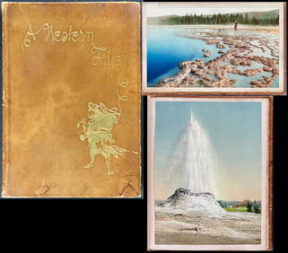
Schmidt's Memoir, A Western Trip - Volume with 12 Photos by William Henry Jackson, 17 by Schmidt andTrillium Antique Prints & Rare Books4.5(30)See Sold PriceFeb 24, 2024
Afrique. Limba Soulimana #26. Guinea Sierra Leone Liberia. VANDERMAELEN 1827 mapJasper524.5(9.8k)See Sold PriceFeb 28, 2024
Afrique. Partie du Sahara #16. Niger & Chad Libya. VANDERMAELEN 1827 old mapJasper524.5(9.8k)See Sold PriceFeb 28, 2024
Afrique. Partie du Désert de Sahara #13. Mauritania Mali. VANDERMAELEN 1827 mapJasper524.5(9.8k)See Sold PriceFeb 28, 2024
EARLY COLONIAL WEST AFRICA. Empires of Sokoto Gando Mas.Tribes.Fellatah 1882 mapJasper524.5(9.8k)See Sold PriceFeb 28, 2024
Afrique. Côte Déserte #48. Skeleton Coast. Namibia. VANDERMAELEN 1827 old mapJasper524.5(9.8k)See Sold PriceFeb 28, 2024
Afrique Pays… sud du Lac Tchad 30 Central African Republic VANDERMAELEN 1827 mapJasper524.5(9.8k)See Sold PriceFeb 28, 2024
Afrique. Partie du Sahara #12. Mauritania. Western Sahara. VANDERMAELEN 1827 mapJasper524.5(9.8k)See Sold PriceFeb 28, 2024
Afrique. Benguela #44. Southern Angola & Northern Namibia. VANDERMAELEN 1827 mapJasper524.5(9.8k)See Sold PriceFeb 28, 2024
Western Africa by Edward Weller. Early British/French settlements 1860 old mapJasper524.5(9.8k)See Sold PriceFeb 28, 2024
WESTERN AFRICA.Kong Mountains.Caravan routes.Slave Coast.TALLIS/RAPKIN 1849 mapJasper524.5(9.8k)See Sold PriceFeb 28, 2024
Afrique. Bambara #20 Niger River. Western Mali. Mauritania VANDERMAELEN 1827 mapJasper524.5(9.8k)See Sold PriceFeb 28, 2024
WEST CENTRAL AFRICA. Congo Angola Gabon Cameroon Sao Tome. MALLET 1683 old mapJasper524.5(9.8k)See Sold PriceFeb 28, 2024
Western Sahara. Africa 1885 old antique vintage map plan chartJasper524.5(9.8k)See Sold PriceFeb 28, 2024
Afrique. Pays des Hottentots #50. Namibia South Africa VANDERMAELEN 1827 mapJasper524.5(9.8k)See Sold PriceFeb 28, 2024
Afrique. Pays des Hottentots #51. Botswana South Africa. VANDERMAELEN 1827 mapJasper524.5(9.8k)See Sold PriceFeb 28, 2024
WESTERN AFRICA.Kong Mountains.Caravan routes.Slave Coast.TALLIS/RAPKIN 1851 mapJasper524.5(9.8k)See Sold PriceFeb 28, 2024
Western coast of Africa… to the River Sanaga. Southern Mauritania LABAT 1745 mapJasper524.5(9.8k)See Sold PriceFeb 28, 2024
Operation Torch Nov 1942-May 1943. World War 2. Western Mediterranean 1966 mapJasper524.5(9.8k)See Sold PriceFeb 28, 2024
Western Africa by Edward Weller. Early British/French settlements 1859 old mapJasper524.5(9.8k)See Sold PriceFeb 28, 2024
PRE COLONIAL WESTERN AFRICA. Shows Mountains of Kong. Tribes. WELLER 1863 mapJasper524.5(9.8k)See Sold PriceFeb 28, 2024
Cooke, George 1801 Antique Map. Sweden, Denmark, Norway, IcelandAlbion Auctions4.6(336)See Sold PriceMar 01, 2024