ATLAS of ANTIENT GEOGRAPHY by SAMUEL BUTLER 1843John McInnis Auctioneers,LLC4.6(504)See Sold PriceFeb 24, 2024
18TH C. ANTIQUE MAP: FRENCH & INDIAN WAR, FRAMEDThomaston Place Auction Galleries4.4(389)See Sold PriceFeb 24, 2024
Rand McNally Railroad Map Cabinet w/ 21 Railroad MapsRail & Road Auctions4.6(165)See Sold PriceMar 08, 2024
Keith Haring - Ink on New York Map, Best Buddies, Inscribed, Signed, and DatedSapphire Auction Gallery4.1(67)See Sold PriceMar 02, 2024
LATE 17TH C. FRENCH MAP OF THE NEW WORLD BY ALEXIS-HUBERT JAILLOT (1632-1712)Thomaston Place Auction Galleries4.4(389)See Sold PriceFeb 24, 2024
Central Railroad of New Jersey Map of Sandy Hook Route-ca. 1903JM Hobby Supply and Railroad Artifact Auctions4.4(126)See Sold PriceFeb 24, 2024
Lot of Six Mixed Atlas Box Cars-HO Scale-New in BoxJM Hobby Supply and Railroad Artifact Auctions4.4(126)See Sold PriceFeb 25, 2024
Rand McNally/Santa Fe Railroad Map of Iowa-1912JM Hobby Supply and Railroad Artifact Auctions4.4(126)See Sold PriceFeb 24, 2024
NICOLAES VISSCHER (NETHERLANDS, 1618-1709) MAP OF THE NEW WORLDThomaston Place Auction Galleries4.4(389)See Sold PriceFeb 24, 2024
17TH C. WORLD MAP BY NICOLAES VISSCHER (NETHERLANDS, 1618-1709)Thomaston Place Auction Galleries4.4(389)See Sold PriceFeb 24, 2024
Lot of Six Mixed Atlas Cabooses-HO Scale-New in BoxJM Hobby Supply and Railroad Artifact Auctions4.4(126)See Sold PriceFeb 25, 2024
SoldW.H. Jackson Cabinet Photo of Iron Whip, PoncaW.H. Jackson Cabinet Photograph of Iron Whip, Ponca Albumen cabinet card with Hayden's U.S. Geological & Geographical Survey of Territories imprint on mount recto. Iron Whip, or Wagasapa, identifiedSee Sold Price
SoldU.S. Geological and Geographical SurveyU.S. Geological and Geographical Survey of the Territories of Wyoming and Idaho 1878 (2 volumes) by F.V. Hayden. U.S. Government Printing Office 1883 VG condition. Provenance: Private collection, DaveSee Sold Price
Sold(NATIVE-AMERICANS) jackson, william henry Grou(NATIVE-AMERICANS) jackson, william henry Group of 3 cabinet card portraits from the "U.S. Geological and Geographical Survey of the Territories, F. V. Hayden, U. S. Geologist in Charge." Albumen prinSee Sold Price
SoldDrainage Map of ColoradoDepartment of the Interior U.S. Geological and Geographical Survey of the Territories, F. V. Hayden. U.S. Geologist in charge. 23"W.x 191/8" L.See Sold Price
SoldColorado Maps (2)Economic, Geological and drainage map of Colorado. Department of the Interior US Geological and Geographical Survey of the Territories. F.V. Hayden, US. Geologist in Charge. 27.5x37.25"See Sold Price
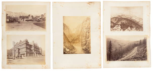
Photographer WILLIAM JACKSON - Stock Cert SignedWilliam H. Jackson (1843-1942) Photographer. Jackson was the official photographer for the U.S. Geological and Geographical Survey of the Territories, and his photographs were instrumental in the estaSee Sold Price
Geological/Geographical Survey..Wyoming and IdahoU.S. Geological and Geographical Survey... Wyoming and Idaho for the year 1878. Washington D.C. P.O.: 1883, 2 vols. Thick Small 4to.See Sold Price
SoldMap of Yellowstone National Park 1878Title: Yellowstone National Park Author: U.S. Geological Survey Description: Lithographed map. 8xx72 cm. (32x28½").Yellowstone National Park from the U.S. Geological and Geographical Survey of the TeSee Sold Price
Map of Yellowtone Lake 1871Title: Yellowstone Lake Wyoming Territory Author: U.S. Geological Survey Description: Lithographed map. 37x38 cm. (14½x15").Map of Yellowstone Lake from the U.S. Geological and Geographical Survey ofSee Sold Price
Economic Map of Portions of Wyoming, Idaho and UtahTitle: Economic Map of Portions of Wyoming, Idaho and Utah Publication Date: 1879-04-01 Cartographer: HAYDEN, FERDINAND VANDIVEER Publisher: U.S. GEOLOGICAL AND GEOGRAPHICAL SURVEY OF THE TERRITORIESSee Sold Price
Preliminary Geological Map of the Yellowstone NationalMap: Preliminary Geological Map of the Yellowstone National Park Date: 1878 Cartographer: HOLMES, W. H./HENRY GANNETT Publisher: U.S. GEOLOGICAL AND GEOGRAPHICAL SURVEY OF THE TERRITORIES Size (inchesSee Sold Price
SoldLot of 25 American Indian Cabinet CardsLot of 25 Cabinet Cards depicting American Indians. Created by the U.S. Department of the Interior for its "Geological & Geographical Survey of the Territories". Images: Jose Pocati; Sleeping Wolf andSee Sold Price
Distribution Map of Washington Indian Tribes 1876Map: Map Showing the Distribution of the Indian Tribes of Washington Territory Maker: U.S. Geographical and Geological Survey of the Rocky Mountain Region Size: 19.75 inches high x 15.5 inches wide DaSee Sold Price
SoldNATIVE AMERICAN INDIAN WOMEN USGS SURVEY COLORADO2 Stereoviews. Each is 4 1/2 x 7 inches. 1) Department of the Interior, U.S. Geographical and Geological Survey of the Rocky Mountain Regions, J.W. Powell, Geologist in Charge. INDIANS OF THE COLORADOSee Sold Price
SoldAMERICAN INDIAN FAMILY USGS POWELL SURVEY HILLERSDepartment of the Interior, U.S. Geographical and Geological Survey of the Rocky Mountain Regions, J. W. Powell, Geologist in Charge. INDIANS OF THE COLORADO VALLEY. U-IN-TATS. Living in the U-in-ta VSee Sold Price
Report on the Geology of the High Plateaus of Utah.Report on the Geology of the High Plateaus of Utah. Department of the Interior. U.S. Geographical and Geological Survey of the Rocky Mountain Region. Frontispiece, xxxii, 307p, 11 heliotype prints, foSee Sold Price
SoldUS Geological Survey - 25 Vols.[Geology]. 25 United States Geologial And Geographical Survey (USGS) Bulletins. Wash: GPO, 1878-1908. 8vo. Wraps. Geology, geography, and hydrology of specified regions of the western US, with attentiSee Sold Price
SoldGeological, geographical atlas of Colorado. Hayden,United States Geological And Geographical Surveys Of The Territories. Geological And Geographical Atlas Of Colorado And Portions Of Adjacent Territory By F.V. Hayden, U.S. Geologist In Charge. CorrectSee Sold Price
SoldLot of Monographs from the U.S. Geological SurveyIncludes: Wheeler, Geo. M. Report upon Geographical and Geological Explorations and Surveys...Vol. III, Part VI. [1875] * Powell, J.W. Report on the Geology of the Eastern Portion of the Uinta MountaiSee Sold Price
SoldUS Geo Survey west of 100th Meridian Vol IIITitle: Report Upon United States Geographical Surveys West of the One Hundredth Meridian... Vol. III, Supplement, Geology (series title). Report upon Geological Examinations in Southern Colorado and NSee Sold Price
Zoo-Geographical Map of North AmericaTitle: Zoo-Geographical Map of North America Prublication Date: 1883 Cartographer: U.S. GEOLOGICAL SURVEY Publisher: U.S.G.S. Size: 16.1Height - 10.9Width Additional Information: From the 12th annualSee Sold Price
SoldUS Geological Survey Map of the United StatesVery large book of US maps, from the whole country. All color topographical maps, featuring quadrant sections. This book measures 28"x19", and has railroads indicated on the maps. These maps are detaiSee Sold Price
Sold7TH ANNUAL US GEOLOGICAL SURVEY 1885-86Powell, J. W. (director); "Seventh Annual Report of the United States Geological Surey to the Secretary of the Interior 1885-86"; Washington Government Printing Office, 1888; many fold out maps and diSee Sold Price
22nd Annual Report Of The U.S. Geological SurveyTitle: Twenty Second Annual Report Of The United States Geological Survey Of The Secretary Of The I Nterior 1900 - 1901 In Four Parts (Part Ii - Ore Deposits) Author: Charles D. Walcott Publishing : GSee Sold Price
1852 CHART SHOWING POSITIONS of DAVIS'S SOUTH SHOAL & OTHER DANGERS antiqueJasper524.5(9.8k)See Sold PriceFeb 27, 2024
Nottingham.- Ordnance Survey Office (publisher) Collection 8 geological maps on the environs ofForum Auctions4.3(53)See Sold PriceFeb 29, 2024
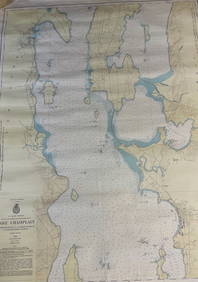
CHART: U.S LAKE SURVEYS/ LAKE CHAMPLAIN/ CUMBERLAND HEAD, NY and SAVAGE ISLAND, VT. TO FOUR BROTHERSChurchill Galleries3.7(216)See Sold PriceFeb 26, 2024
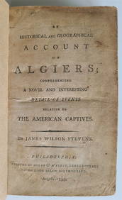
1797 PIRACY: A HISTORICAL & GEOGRAPHICAL ACCOUNT OF ANCIENNY Elizabeth 4.3(85)See Sold PriceMar 03, 2024
Virginia and West Virginia Topography MapsRapid Estate Liquidators and Auction Gallery4.5(1.1k)See Sold PriceFeb 28, 2024
(3) Copper Print Plates of N. Carolina & TennesseeWilliam Bunch Auctions & Appraisals4.6(878)See Sold PriceFeb 27, 2024


![Untitled. [Eastern U.S., Gulf of Mexico and Caribbean] (1 of 5)](https://p1.liveauctioneers.com/5584/319958/171812128_1_x.jpg?height=282&quality=70&version=1708466739)