ATLAS of ANTIENT GEOGRAPHY by SAMUEL BUTLER 1843John McInnis Auctioneers,LLC4.5(505)See Sold PriceFeb 24, 2024
18TH C. ANTIQUE MAP: FRENCH & INDIAN WAR, FRAMEDThomaston Place Auction Galleries4.4(393)See Sold PriceFeb 24, 2024
Rand McNally Railroad Map Cabinet w/ 21 Railroad MapsRail & Road Auctions4.6(165)See Sold PriceMar 08, 2024
Keith Haring - Ink on New York Map, Best Buddies, Inscribed, Signed, and DatedSapphire Auction Gallery4(67)See Sold PriceMar 02, 2024
LATE 17TH C. FRENCH MAP OF THE NEW WORLD BY ALEXIS-HUBERT JAILLOT (1632-1712)Thomaston Place Auction Galleries4.4(393)See Sold PriceFeb 24, 2024
Central Railroad of New Jersey Map of Sandy Hook Route-ca. 1903JM Hobby Supply and Railroad Artifact Auctions4.4(127)See Sold PriceFeb 24, 2024
Lot of Six Mixed Atlas Box Cars-HO Scale-New in BoxJM Hobby Supply and Railroad Artifact Auctions4.4(127)See Sold PriceFeb 25, 2024
Rand McNally/Santa Fe Railroad Map of Iowa-1912JM Hobby Supply and Railroad Artifact Auctions4.4(127)See Sold PriceFeb 24, 2024
NICOLAES VISSCHER (NETHERLANDS, 1618-1709) MAP OF THE NEW WORLDThomaston Place Auction Galleries4.4(393)See Sold PriceFeb 24, 2024
17TH C. WORLD MAP BY NICOLAES VISSCHER (NETHERLANDS, 1618-1709)Thomaston Place Auction Galleries4.4(393)See Sold PriceFeb 24, 2024
Lot of Six Mixed Atlas Cabooses-HO Scale-New in BoxJM Hobby Supply and Railroad Artifact Auctions4.4(127)See Sold PriceFeb 25, 2024
SoldU.S Coast Survey 1853 Map. Gargathy Machipongo Inlet VA"Preliminary Chart of the Sea Coast of Virginia From Gagathy Inlet to Gr. Machipongo Inlet" Electrotype Map Published 1843-65, Washington for "Report of the Superintendent of the U.S. Coast Survey..."See Sold Price
U.S Coast Survey 1853 Map. Gargathy Machipongo Inlet VA"Preliminary Chart of the Sea Coast of Virginia From Gagathy Inlet to Gr. Machipongo Inlet" Electrotype Map Published 1843-65, Washington for "Report of the Superintendent of the U.S. Coast Survey..."See Sold Price
U.S Coast Survey 1853 Map. Gargathy Machipongo Inlet VA"Preliminary Chart of the Sea Coast of Virginia From Gagathy Inlet to Gr. Machipongo Inlet" Electrotype Map Published 1843-65, Washington for "Report of the Superintendent of the U.S. Coast Survey..."See Sold Price
U.S Coast Survey 1853 Map. Gargathy Machipongo Inlet VA"Preliminary Chart of the Sea Coast of Virginia From Gagathy Inlet to Gr. Machipongo Inlet" Electrotype Map Published 1843-65, Washington for "Report of the Superintendent of the U.S. Coast Survey..."See Sold Price
U.S Coast Survey 1853 Map. Gargathy Machipongo Inlet VA"Preliminary Chart of the Sea Coast of Virginia From Gagathy Inlet to Gr. Machipongo Inlet" Electrotype Map Published 1843-65, Washington for "Report of the Superintendent of the U.S. Coast Survey..."See Sold Price
U.S Coast Survey 1853 Map. Gargathy Machipongo Inlet VA"Preliminary Chart of the Sea Coast of Virginia From Gagathy Inlet to Gr. Machipongo Inlet" Electrotype Map Published 1843-65, Washington for "Report of the Superintendent of the U.S. Coast Survey..."See Sold Price
SoldU.S Coast Survey 1853 Map. Cherrystone Inlet, Virginia"Preliminary Sketch of Cherrystone Inlet" Electrotype Map Published 1843-65, Washington for "Report of the Superintendent of the U.S. Coast Survey..." Published under the supervision and direction ofSee Sold Price
U.S Coast Survey 1853 Map. Cherrystone Inlet, Virginia"Preliminary Sketch of Cherrystone Inlet" Electrotype Map Published 1843-65, Washington for "Report of the Superintendent of the U.S. Coast Survey..." Published under the supervision and direction ofSee Sold Price
SoldU.S. Coast Survey 1853 Map of Aransas Pass, Texas"Reconnoissance of Aransas Pass Texas" Electrotype Map Published 1843-65, Washington for "Report of the Superintendent of the U.S. Coast Survey..." Published under the supervision and direction of AleSee Sold Price
SoldU.S. Coast Survey 1853 Map of Long Island, New Jersey"Sketch B Showing the progress of Section No. 2" Electrotype Map Published 1843-65, Washington for "Report of the Superintendent of the U.S. Coast Survey..." Published under the supervision and directSee Sold Price
SoldU.S. Coast Survey 1853 Map of Cape Cod, MA, NH"Sketch A Shewing the progress of the Survey in Section No. 1" Electrotype Map Published 1843-65, Washington for "Report of the Superintendent of the U.S. Coast Survey..." Published under the supervisSee Sold Price
SoldU.S Coast Survey 1853 Map of Pungoteague Creek Virginia"Preliminary Sketch of Pungoteague Creek Virginia" Electrotype Map Published 1843-65, Washington for "Report of the Superintendent of the U.S. Coast Survey..." Published under the supervision and direSee Sold Price
SoldU.S. Coast Survey 1853 Map of Galveston Entrace, Texas"(Sketch I No. 3) Galveston Entrance Texas" Electrotype Map Published 1843-65, Washington for "Report of the Superintendent of the U.S. Coast Survey..." Published under the supervision and direction oSee Sold Price
SoldU.S Coast Survey 1853 Map. Ship Island Shoal, Louisiana"Preliminary Chart of Ship Island Shoal Louisiana" Electrotype Map Published 1843-65, Washington for "Report of the Superintendent of the U.S. Coast Survey..." Published under the supervision and direSee Sold Price
SoldU.S Coast Survey 1853 Map. Cortez Bank, California"Cortez Bank on the Western Coast of the United States" Electrotype Map Published 1843-65, Washington for "Report of the Superintendent of the U.S. Coast Survey..." Published under the supervision andSee Sold Price
SoldU.S Coast Survey 1853 Map. Timballier Bay, Louisiana"Preliminary Reconnaissance of Grand Pass Entrance to Timballier Bay Louisiana" Electrotype Map Published 1843-65, Washington for "Report of the Superintendent of the U.S. Coast Survey..." Published uSee Sold Price
SoldU.S Coast Survey 1853 Map. Barataria Bay, Louisiana"Preliminary Reconnaissance of Entrance to Barataria Bay Louisiana" Electrotype Map Published 1843-65, Washington for "Report of the Superintendent of the U.S. Coast Survey..." Published under the supSee Sold Price
SoldU.S. Coast Survey 1853 Map of St. Georges Sound,"Preliminary Reconnaissance of the Middle or Main, and West Entrances to St. Georges Sound Florida" Electrotype Map Published 1843-65, Washington for "Report of the Superintendent of the U.S. Coast SuSee Sold Price
U.S Coast Survey 1853 Map. Ship Island Shoal, Louisiana"Preliminary Chart of Ship Island Shoal Louisiana" Electrotype Map Published 1843-65, Washington for "Report of the Superintendent of the U.S. Coast Survey..." Published under the supervision and direSee Sold Price
U.S Coast Survey 1853 Map. Ship Island Shoal, Louisiana"Preliminary Chart of Ship Island Shoal Louisiana" Electrotype Map Published 1843-65, Washington for "Report of the Superintendent of the U.S. Coast Survey..." Published under the supervision and direSee Sold Price
U.S Coast Survey 1853 Map. Barataria Bay, Louisiana"Preliminary Reconnaissance of Entrance to Barataria Bay Louisiana" Electrotype Map Published 1843-65, Washington for "Report of the Superintendent of the U.S. Coast Survey..." Published under the supSee Sold Price
U.S Coast Survey 1853 Map. Cortez Bank, California"Cortez Bank on the Western Coast of the United States" Electrotype Map Published 1843-65, Washington for "Report of the Superintendent of the U.S. Coast Survey..." Published under the supervision andSee Sold Price
Sold1853 U.S. Coast Survey Map of New Orleans1853 U.S. Coast Survey Map of New Orleans, Lake Pontchartrain and the Mississippi Delta hand-colored lithograph, inscribed "U.S. Coast Survey, A. D. Bache Superintendent, Sketch H, Showing the progresSee Sold Price
Sold1853 US Coast Survey Map Of San Francisco"U.S. Coast Survey A.D. Bache, Superintendent, City Of San Francisco And Its Vicinity California. From a Trigonometrical Survey by R.D. Cutts, Assistant. Topography by A.F. Rodgers Sub-assistant. HydrSee Sold Price
Emma Levinia Swan (RI,German,1853-1927) oil painting antiqueBroward Auction Gallery4.7(292)See Sold PriceMar 10, 2024
Oliver Clare (UK,1853-1927) oil painting antiqueBroward Auction Gallery4.7(292)See Sold PriceMar 10, 2024
Central Railroad of New Jersey Map of Sandy Hook Route-ca. 1903JM Hobby Supply and Railroad Artifact Auctions4.4(127)See Sold PriceFeb 24, 2024
Southern Pacific RR Four Gateways to the Pacific Coast Brochure-1917JM Hobby Supply and Railroad Artifact Auctions4.4(127)See Sold PriceFeb 24, 2024
FLYING A TOURING SERVICE U.S. ROAD MAPS TIN WALL DISPLAY.Dan Morphy Auctions4.2(1.3k)See Sold PriceFeb 25, 2024
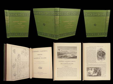
1874 HAWAII 1ed Northern California Oregon Pacific Island Travel Puget RedwoodsSchilb Antiquarian Rare Books4.8(428)See Sold PriceMar 10, 2024
1885 CIVIL WAR 1ed Famous Memoirs US Grant Sheridan Sherman 6v RARE LOT MapsSchilb Antiquarian Rare Books4.8(428)See Sold PriceMar 10, 2024
BOTH TITLE PAGES OF COLLINS" COASTAL SURVEY, 1776, IN MATCHING FRAMESThomaston Place Auction Galleries4.4(393)See Sold PriceFeb 24, 2024
1963 J.F.K. for US PRESIDENT RE-ELECTION MATERIALJohn McInnis Auctioneers,LLC4.5(505)See Sold PriceFeb 25, 2024
Jerusalem Map for British Soldiers in Palestine - WW2Levy Auction House4.3(11)See Sold PriceFeb 27, 2024
1853 Colton's Railroad & Township Map of Massachusetts, Rhode Island, and ConnecticutRail & Road Auctions4.6(165)See Sold PriceMar 07, 2024
Alton S. Tobey, Toward the Arctic SunLotus International Auctions, LLC4.6(153)See Sold PriceMar 03, 2024
[MAP]. NICHOLLS, Sutton (1668-1729). An Epitome of Sr. Will...Potter & Potter Auctions4.6(545)See Sold PriceMar 07, 2024
[VIETNAM]. A group of approx. 120 photographs assembled by African American soldier Vernon CliftonFreeman's | Hindman4.4(1.6k)See Sold PriceFeb 27, 2024
West Coast U.S. Vintage Travel Maps, Brochures 46Grant Zahajko Auctions, LLC4.7(1k)See Sold PriceMar 06, 2024


![[Daguerreotype] c. 1853 Dragoon (1 of 1)](https://p1.liveauctioneers.com/7226/317626/170485456_1_x.jpg?height=282&quality=70&version=1706368022)


![[MAP]. NICHOLLS, Sutton (1668-1729). An Epitome of Sr. Will... (1 of 1)](https://p1.liveauctioneers.com/928/318880/171361281_1_x.jpg?height=282&quality=70&version=1707501302)
![[VIETNAM]. A group of approx. 120 photographs assembled by African American soldier Vernon Clifton (1 of 6)](https://p1.liveauctioneers.com/197/319238/171468143_1_x.jpg?height=282&quality=70&version=1707520367)