ATLAS of ANTIENT GEOGRAPHY by SAMUEL BUTLER 1843John McInnis Auctioneers,LLC4.5(505)See Sold PriceFeb 24, 2024
18TH C. ANTIQUE MAP: FRENCH & INDIAN WAR, FRAMEDThomaston Place Auction Galleries4.4(393)See Sold PriceFeb 24, 2024
Rand McNally Railroad Map Cabinet w/ 21 Railroad MapsRail & Road Auctions4.6(165)See Sold PriceMar 08, 2024
Keith Haring - Ink on New York Map, Best Buddies, Inscribed, Signed, and DatedSapphire Auction Gallery4.1(67)See Sold PriceMar 02, 2024
LATE 17TH C. FRENCH MAP OF THE NEW WORLD BY ALEXIS-HUBERT JAILLOT (1632-1712)Thomaston Place Auction Galleries4.4(393)See Sold PriceFeb 24, 2024
Central Railroad of New Jersey Map of Sandy Hook Route-ca. 1903JM Hobby Supply and Railroad Artifact Auctions4.4(127)See Sold PriceFeb 24, 2024
Lot of Six Mixed Atlas Box Cars-HO Scale-New in BoxJM Hobby Supply and Railroad Artifact Auctions4.4(127)See Sold PriceFeb 25, 2024
Rand McNally/Santa Fe Railroad Map of Iowa-1912JM Hobby Supply and Railroad Artifact Auctions4.4(127)See Sold PriceFeb 24, 2024
NICOLAES VISSCHER (NETHERLANDS, 1618-1709) MAP OF THE NEW WORLDThomaston Place Auction Galleries4.4(393)See Sold PriceFeb 24, 2024
17TH C. WORLD MAP BY NICOLAES VISSCHER (NETHERLANDS, 1618-1709)Thomaston Place Auction Galleries4.4(393)See Sold PriceFeb 24, 2024
Lot of Six Mixed Atlas Cabooses-HO Scale-New in BoxJM Hobby Supply and Railroad Artifact Auctions4.4(127)See Sold PriceFeb 25, 2024
SoldUnusual Early Edwardian Project MapJohnston, W. & A. K. United States & Mexico constructed and engraved by W. & A.K. Johnston... Lithographed map. c. 1903. 41" x 49 ¼" sheet. Handsome and artistic schoolroom map on spring roller witSee Sold Price
unusual Early Map Of Boston Circa 1833.unusual Early Map Of Boston Circa 1833. Measures 26 x 32 inches.See Sold Price
1872 Map of Penn. Mineral Deposits – Walling, GrayMap of Pennsylvania Showing the Principal Deposits of Iron, Anthracite, Coal, Petroleum and Zinc.” Unusual early map, colored to show distribution of mineral deposits. Shows area in northwest part oSee Sold Price
1872 Geological map of Penn. – Walling, Gray1872 Topographical Map of Pennsylvania, Colored for the Principal Geological Formations,” by J. Peters. Lovely, colorful presentation with period hand coloring. Unusual early map, colored to show thSee Sold Price
1872 Map of Penn. Flora – Walling, GrayMap of Pennsylvania colored to Illustrate the Distribution of its Flora,” by Thos. C. Porter. Hand colored engraving. Unusual early map, colored to show the distribution of plants in the state. FromSee Sold Price
UNUSUAL EARLY HANDCOLORED FRENCH MAP. EUNUSUAL EARLY HANDCOLORED FRENCH MAP. Engraving with small areas of red, green and yellow coloring. Dated 1703, by N. de Fer of the theater of war in Germany. Margins have been cut. 19 3/4" x 46 1/2"See Sold Price
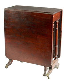
SoldUnusual form early 19thC period cherry & tiger mapUnusual form early 19thC period cherry & tiger maple 2 drawer dropleaf work stand on turned legs w unusually long drawers - 28 1/2" tallSee Sold Price
SoldEarly Postcard Unusual Rare American MapABOUT POSTCARDS: The study and collecting of postcards is termed deltiology (from Greek deltion, small writing tablet, and English -logy, the study of). Rarity. As with all antique items, rarity bringSee Sold Price
Sold1835 map of United States – Samuel GoodrichSmall, attractive hand-colored map of the U. S. in 1835. Shows unusual early Texas and huge western territories. Some minor foxing. Modern hand color. 4.25 x 6. Reserve: $70.00 Shipping: Domestic: FlSee Sold Price
Italian Map of Northern U.S. 1826Map: Le Provincie Settentrionali Degli Stati Uniti. Italian Map of Northern U.S Date: 1826 Size: Quarto, 12.1 inches high x 18.10 inches wide Unusual early 19th Cent. U.S. Shows east and New England tSee Sold Price
Le Provincie Meridionali Degli Stati UnitiTitle/Content of Map: Le Provincie Meridionali Degli Stati Uniti Date Printed: 1800 ca. Cartographer: ANONYMOUS Size: 12.6X17.8 Unusual early 19th Cent. U.S. Shows Southeast west to about Nashville. SSee Sold Price
SoldRare 1921 auto road atlas. 11.7 x 15Reserve Reduced! This rare and unusual early auto road atlas was published during the time the National Highway System was being developed. It includes individual “auto-trails” maps for each stateSee Sold Price
Map of Dakota, Wyoming, Kansas, Nebraska & ColoradoS. Augustus Mitchell, Jr., Mitchell, Samuel Augustus, Jr., 1870, Folio – 19.80 H x 14.80 W Inches, Unusual regional map that shows early Colorado in some detail. Douglas Couinty extends to the KansaSee Sold Price
SoldPatent Form Victorian ChairDESCRIPTION: A late Victorian or early Edwardian patent form arm chair, probably American. Patent furniture describes a wide range of unusual formed late 19th century furniture that was designed and pSee Sold Price
Aspin: Antique Map of North and South America, 1838Title/Content of Map: North and South America. Early American Project Map Publication Date: 1838 Authors: JOHN HARRIS, ASPIN, JEHOSHOPHAT/N. R. HEWITT, sc. Publisher: JOHN HARRIS Size: Folio –See Sold Price
SoldUnusual Edwardian Mahogany Revolving StandUnusual Edwardian Mahogany Revolving Stand, early 20th century, fitted with three graduated tiers, each of concave tripartite form and with spindled galleries supported by bulbous uprights, the wholeSee Sold Price
SoldWorld.- Zahn (Johannes) TabulaWorld.- Zahn (Johannes) Tabula Geographico-Hydrographica Motus Oceani Currentes, Abyssos, Montes Igniuomos in Universo, an unusual example of early thematic cartography, illustrating ocean currents, vSee Sold Price
SoldEnglish Edwardian Carved Nut Walking Stick CaneEarly 20th Century Edwardian, English malacca cane with hand carved coquilla nut knop, in the form of an acorn with carved leaf patterns. Unusual & interesting example. Approx 33" overall lengthSee Sold Price
SoldAmerican QuiltAmerican Edwardian Couch-Embroidered And Quilted Coverlet, early 20th Century, unusual design detailed with white steps on a pink ground, with Art Nouveau style pink tulips and chrysanthemums on quiltSee Sold Price
SoldAmerican QuiltAmerican Edwardian Couch-Embroidered And Quilted Coverlet, early 20th Century, unusual design detailed with white steps on a pink ground, with Art Nouveau style pink tulips and chrysanthemums on quiltSee Sold Price
English Edwardian Carved Nut Walking Stick CaneEarly 20th Century Edwardian, English malacca cane with hand carved coquilla nut knop, in the form of an acorn with carved leaf patterns. Unusual & interesting example. Approx 33" overall lengthSee Sold Price
English Edwardian Carved Nut Walking Stick CaneEarly 20th Century Edwardian, English malacca cane with hand carved coquilla nut knop, in the form of an acorn with carved leaf patterns. Unusual & interesting example. Approx 33" overall lengthSee Sold Price
English Edwardian Carved Nut Walking Stick CaneEarly 20th Century Edwardian, English malacca cane with hand carved coquilla nut knop, in the form of an acorn with carved leaf patterns. Unusual & interesting example. Approx 33" overall lengthSee Sold Price
SoldUNUSUAL EDWARDIAN ROTATING CANTERBURYEdwardian rotating canterbury, early 20th c., four storage slots divided by brass screens set on the rectangular base, all rising on stretcher joined tubular brass tripod base, mark of Hall & Sons, BiSee Sold Price
AN UNUSUAL EARLY 19TH CENTURY WALNUT CUMBERLAND TYPE GATE LEG TABLEHutchinson Scott Auctioneers4.4(42)See Sold PriceFeb 28, 2024
AN UNUSUAL EARLY 20TH CENTURY MINIATURE ELECTRIC BAROGRAPHHutchinson Scott Auctioneers4.4(42)See Sold PriceFeb 28, 2024
Unusual Early 1800s Ovoid 1 Gallon Salt Glazed Jar w/ Applied HandlesHoller and Hammer4.6(64)See Sold PriceFeb 24, 2024
WEST AFRICA Explorers' routes Senegal Ashanti. Mountains of Kong. SDUK 1857 mapJasper524.5(9.9k)See Sold PriceFeb 28, 2024
AFRICA. Map pre-dating much exploration. Mountains of Kong. SDUK 1851 oldJasper524.5(9.9k)See Sold PriceFeb 28, 2024
WEST AFRICA explorers' routes. Beaufort Gray Park Dochard Caillie. SDUK 1874 mapJasper524.5(9.9k)See Sold PriceFeb 28, 2024
WEST AFRICA I Explorers' routes Senegal Ashanti Ivory Gold Coast. SDUK 1851 mapJasper524.5(9.9k)See Sold PriceFeb 28, 2024
WEST AFRICA showing early explorers' routes & Mountains of Kong. SDUK 1844 mapJasper524.5(9.9k)See Sold PriceFeb 28, 2024
PRE COLONIAL WESTERN AFRICA. Shows Mountains of Kong. Tribes. WELLER 1863 mapJasper524.5(9.9k)See Sold PriceFeb 28, 2024
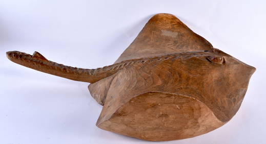
A LARGE AND UNUSUAL EARLY 20TH CENTURY CARVED ELM FIGURE OF A RAY of naturalistic form. 60 cm x 40 cHannam's Auctioneers Ltd4.3(396)See Sold PriceFeb 27, 2024
AN UNUSUAL EARLY 20TH CENTURY AFRICAN PAINTED WOOD AND HIDE TRIBAL MONKEY HELMUT. 27 cm x 27 cm.Hannam's Auctioneers Ltd4.3(396)See Sold PriceFeb 27, 2024
AN UNUSUAL EARLY 20TH CENTURY NOVELTY SILVER PLATED PUNCH TABLE LIGHTER. 17 cm high.Hannam's Auctioneers Ltd4.3(396)See Sold PriceFeb 27, 2024
AN UNUSUAL EARLY HAWIAN CARVED VOLCANIC STONE POUNDER of almost rhinoceros horn form. 21 cm high.Hannam's Auctioneers Ltd4.3(396)See Sold PriceFeb 27, 2024
AN UNUSUAL EARLY 20TH CENTURY DAYAK TRIBAL WOOD SPOON. 19 cm long.Hannam's Auctioneers Ltd4.3(396)See Sold PriceFeb 27, 2024
AN UNUSUAL EARLY 20TH CENTURY ENGLISH STONEWARE JUG formed as a standing dog. 24 cm high.Hannam's Auctioneers Ltd4.3(396)See Sold PriceFeb 27, 2024
AN UNUSUAL EARLY 20TH CENTURY CHINESE CARVED ICY JADEITE PLAQUE Late Qing/Republic. 3 cm x 2 cm.Hannam's Auctioneers Ltd4.3(396)See Sold PriceFeb 29, 2024
AN UNUSUAL EARLY 20TH CENTURY CHINESE SILVER GILT AND ENAMEL FIGURE OF BIRDS Late Qing/Republic. 42.Hannam's Auctioneers Ltd4.3(396)See Sold PriceFeb 29, 2024