ATLAS of ANTIENT GEOGRAPHY by SAMUEL BUTLER 1843John McInnis Auctioneers,LLC4.6(502)See Sold PriceFeb 24, 2024
18TH C. ANTIQUE MAP: FRENCH & INDIAN WAR, FRAMEDThomaston Place Auction Galleries4.4(386)See Sold PriceFeb 24, 2024
Rand McNally Railroad Map Cabinet w/ 21 Railroad MapsRail & Road Auctions4.6(165)See Sold PriceMar 08, 2024
Keith Haring - Ink on New York Map, Best Buddies, Inscribed, Signed, and DatedSapphire Auction Gallery4(67)See Sold PriceMar 02, 2024
LATE 17TH C. FRENCH MAP OF THE NEW WORLD BY ALEXIS-HUBERT JAILLOT (1632-1712)Thomaston Place Auction Galleries4.4(386)See Sold PriceFeb 24, 2024
Central Railroad of New Jersey Map of Sandy Hook Route-ca. 1903JM Hobby Supply and Railroad Artifact Auctions4.4(126)See Sold PriceFeb 24, 2024
Lot of Six Mixed Atlas Box Cars-HO Scale-New in BoxJM Hobby Supply and Railroad Artifact Auctions4.4(126)See Sold PriceFeb 25, 2024
Rand McNally/Santa Fe Railroad Map of Iowa-1912JM Hobby Supply and Railroad Artifact Auctions4.4(126)See Sold PriceFeb 24, 2024
NICOLAES VISSCHER (NETHERLANDS, 1618-1709) MAP OF THE NEW WORLDThomaston Place Auction Galleries4.4(386)See Sold PriceFeb 24, 2024
17TH C. WORLD MAP BY NICOLAES VISSCHER (NETHERLANDS, 1618-1709)Thomaston Place Auction Galleries4.4(386)See Sold PriceFeb 24, 2024
Lot of Six Mixed Atlas Cabooses-HO Scale-New in BoxJM Hobby Supply and Railroad Artifact Auctions4.4(126)See Sold PriceFeb 25, 2024
United States. Rand, McNally & Co.'s Indexed Atlas ofTitle: United States. Rand, McNally & Co.'s Indexed Atlas of the World (Complete in Two Volumes) Publication Date: 1896 Primary Authors: RAND, MCNALLY & COMPANY Publisher: RAND, MCNALLY & COMPANY DescSee Sold Price
United States. Rand, McNally & Co.'S Indexed Atlas ofPublication Date: 1896 Title: United States. Rand, McNally & Co.'S Indexed Atlas of the World (Complete in Two Volumes) Primary Authors: RAND, MCNALLY & COMPANY Publisher: RAND, MCNALLY & COMPANY contSee Sold Price
SoldRand McNally Index Atlas of the World Vol 1 1902Rand McNally Indexed Atlas of the World Historical - Descriptive - Statistical Volume I - United States, Rand McNally & Co, Chicago, 1902. Color engraved atlas of the United States.See Sold Price
Crops of Corn, Wheat, and Oats in the United StatesPrint: Crops of Corn, Wheat, and Oats in the United States, 1891 & Crops of Corn, Wheat and Oats in the United States, 1870-1891 Publishing: Rand, McNally & Co. 1898 From the New Standard Atlas of theSee Sold Price
SoldRAND-MCNALLY INDEXED ATLAS OF THE WORLDRAND-MCNALLY INDEXED ATLAS OF THE WORLD, REVISED EDITION, SIZE 15 X 21, WITH 275 ILLUSTRATIONS, HISTORICAL-DESCRIPTIVE-STATISTICAL VOL. 1 UNITED STATES, CONTAINING LARGE SCALE MAPS OF ALL THE STATES ASee Sold Price
SoldRAND, McNALLY & CO.’S BUSINESS ATLAS. Chi: 1878.[Atlas]. RAND, McNALLY & CO.’S BUSINESS ATLAS Containing Large Scale Maps of Each State and Territory of the United States, the Provinces of Canada, West India Islands, Etc., Etc… Chi: Rand, McNalSee Sold Price
MAPS - Western US, Railroads. Rand McNallyWestern United States, Railroads. Rand McNally& Co., [Lot of 2] Map of the Chicago, Rock Island & Pacific Railway and Connections [and] Map Exhibiting the Leading Transportation Lines of the Pacific CSee Sold Price
Untitled. [United States]c1907 Title: Untitled. [United States] Cartographer: RAND, MCNALLY & CO. Publisher: RAND, MCNALLY & CO. Height: 30.5 Width: 42.25 Detailed large scale national map, 82 miles to the inch. Folds into prSee Sold Price
SoldRand, McNally & Co.'s New Handy Atlas ContainingTitle/Content of Map: Rand, McNally & Co.'s New Handy Atlas Containing Colored County Maps of the United States And the Dominion of Canada Date: 1893 Cartographer: RAND, MCNALLY & CO Publisher: RAND,See Sold Price
Rand, McNally & Co Improved Indexed Business Atlas 1888Rand, McNally & Co's Improved Indexed Business Atlas and Shipper's Guide. Containing large scale maps of dominion of Canada, Old Mexico, Central America, Cuba, and the several states and territories oSee Sold Price
SoldRand McNally NEW DOLLAR ATLAS 1884 U.S. & CanadaTitle: Rand, McNally & Co.'s New Dollar Atlas of the United States and Dominion of Canada Publisher: Continental Publishing Co. Printing Year: 1884 Condition/Details: Bound in decorative hardcover, tSee Sold Price
SoldRand McNally Business Atlas 1893Title: Rand, McNally & Co.'s Enlarged Business Atlas and Shippers' Guide, Containing Large-Scale Maps of All States and Territories in the United States, the Dominion of Canada, Old Mexico, Central AmSee Sold Price
SoldMap of the United States showing Density of PopulationRand, McNally & Co. 1898 New Standard Atlas of the World. Also contains census information on population 1870, 1880, and 1890 Size: 21 x 15 inches No Reserve: This lot starts at $1 and has no reserveSee Sold Price
SoldRand McNally & Co's State & Counry Survey Atlas$18 Shipping/handling/insurance (up to 100) shipped in the continental United States. We do not combine shipping as the packages are sealed and labeled immediately after the item is sold. InternationaSee Sold Price
Coal Fields of the United States.Title: Coal Fields of the United States. Prublication Date: 1906 Cartographer: RAND, MCNALLY & CO. Publisher: RAND, MCNALLY & CO. Size: 15.5Height - 26Width Additional Information: Coal area territorySee Sold Price
New Official Railroad Map of the United States andTitle/Content of Map: New Official Railroad Map of the United States and Dominion of Canada Date: c1909 Cartographer: RAND MCNALLY & CO. Publisher: RAND MCNALLY & CO. Size: 28Height - 38.5Width FoldsSee Sold Price
Huge Rand, McNally Railroad Pocket Map of the U.S.Rand, McNally & Co. (fl. 1856-Present). Rand, McNally & Co.'s New Official Railroad Map of the United States Canada And Mexico. Lithographed map. Rand McNally & Co., 1886. 31 ½" x 44 ½" sheet. VSee Sold Price
Special Rand McNally Physical-Political UnitedTitle/Content of Map: Special Rand McNally Physical-Political United States... Date Printed: 6/1/1941 Cartographer: RAND MCNALLY & CO. Size: 42.5x63 Folding national map on fabric, in stiff brown coveSee Sold Price
SoldAtlas of the WorldRand McNally & Co. Volume 1: United States. Copyright 1902. Color plates. 20-3/4" long (closed).See Sold Price
Rand, McNally & Co.'S New Official Railroad Map of theReserve Reduced! Title: Rand, McNally & Co.'S New Official Railroad Map of the United States And Dominion of Canada Publication Date: 1903 Cartographer: RAND, MCNALLY & CO. Publisher: RAND, MCNALLY &See Sold Price
Rand McNally: Antique Railroad Map of the United StatesTitle/Content of Map: Rand McNally & Co.'s New Railroad and County Map of the United States And Dominion of Canada Date Printed: 1882 Cartographer: RAND, MCNALLY & CO. Size: 26.5X44 Some fold repairs.See Sold Price
Rand, McNally & Co.'s New Official Railroad Map of theMap: Rand, McNally & Co.'s New Official Railroad Map of the United States And Canada. Date: 1910 ca. Cartographer: RAND, MCNALLY & CO. Publisher: RAND, MCNALLY & CO. | J.L. SMITH Size (inches): 26.5x4See Sold Price
SoldReligious Denominations in the United States, 1890Print: Religious Denominations in the United States 1890, The Creeds of the World Maker: Rand, McNally & Co. Printing Date: 1898 Size: 21.5 x 15 inches From New Standard Atlas of the World No Reserve:See Sold Price
Rand McNally: Antique Railroad Map of United StatesTitle/Content of Map: Rand, McNally & Co.'S New Official Railroad Map of the United States Canada And Mexico. Huge Rand, McNally Railroad Pocket Map of the U.S. Publication Date: 1886 Authors: RAND, MSee Sold Price
Rand McNally & Co's New Ideal State and County Survey and Atlas 1911North American Artifact Auctions4.6(182)See Sold PriceApr 20, 2024
The World And It's Peoples Photographed And Described 1910 Folio SizeNorth American Artifact Auctions4.6(182)See Sold PriceApr 20, 2024
1905 20th Century Atlas of Boone County IllinoisMatthew Bullock Auctioneers4.7(1.8k)See Sold PriceFeb 24, 2024
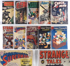
10PC Atlas DC Dell Golden Silver Age Comics GroupBruneau & Co. Auctioneers4.5(491)See Sold PriceFeb 24, 2024
18 Atlas DC Quality Comics Golden Silver Age GroupBruneau & Co. Auctioneers4.5(491)See Sold PriceFeb 24, 2024
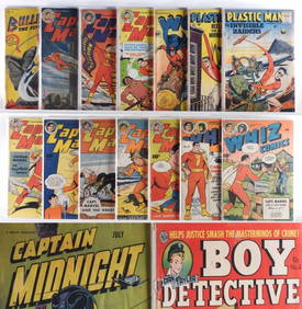
32PC Estate Fresh Golden Age Crime Hero GroupBruneau & Co. Auctioneers4.5(491)See Sold PriceFeb 24, 2024
10PC Atlas Comics Dell Combat War Golden Age GroupBruneau & Co. Auctioneers4.5(491)See Sold PriceFeb 24, 2024
Atlas Comics Journey Into Mystery #62 CGC 4.5Bruneau & Co. Auctioneers4.5(491)See Sold PriceFeb 24, 2024
Atlas Comics Sub-Mariner Comics #36 CGC 3.5Bruneau & Co. Auctioneers4.5(491)See Sold PriceFeb 24, 2024
West Indies. Rand, McNally & Co.'S Indexed Atlas Map of the West Indies.Jasper524.5(9.8k)See Sold PriceFeb 27, 2024
Framed Space Age Rand McNally Map of Planets Poster, 1958PUBLIC SALE4.7(217)See Sold PriceMar 02, 2024
Vintage Street Map of Pittsburgh, Pennsylvania - Rand McNallyProverde Auctions4.3(3)See Sold PriceFeb 28, 2024
Stamps and Collector Plate's BooksRapid Estate Liquidators and Auction Gallery4.5(1.1k)See Sold PriceFeb 27, 2024
Vintage 1920s Rand McNally Auto Trails MapThe Benefit Shop Foundation Inc.4.3(2.9k)See Sold PriceMar 20, 2024
New Concise Dictionary Thesaurus Hardcover Book Set 1986Rapid Estate Liquidators and Auction Gallery4.5(1.1k)See Sold PriceMar 03, 2024


![Untitled. [United States] (1 of 1)](https://p1.liveauctioneers.com/5584/155577/78518572_1_x.jpg?height=282&quality=70&version=1574821323)