ATLAS of ANTIENT GEOGRAPHY by SAMUEL BUTLER 1843John McInnis Auctioneers,LLC4.6(502)See Sold PriceFeb 24, 2024
18TH C. ANTIQUE MAP: FRENCH & INDIAN WAR, FRAMEDThomaston Place Auction Galleries4.4(386)See Sold PriceFeb 24, 2024
Rand McNally Railroad Map Cabinet w/ 21 Railroad MapsRail & Road Auctions4.6(165)See Sold PriceMar 08, 2024
Keith Haring - Ink on New York Map, Best Buddies, Inscribed, Signed, and DatedSapphire Auction Gallery4(67)See Sold PriceMar 02, 2024
LATE 17TH C. FRENCH MAP OF THE NEW WORLD BY ALEXIS-HUBERT JAILLOT (1632-1712)Thomaston Place Auction Galleries4.4(386)See Sold PriceFeb 24, 2024
Central Railroad of New Jersey Map of Sandy Hook Route-ca. 1903JM Hobby Supply and Railroad Artifact Auctions4.4(126)See Sold PriceFeb 24, 2024
Lot of Six Mixed Atlas Box Cars-HO Scale-New in BoxJM Hobby Supply and Railroad Artifact Auctions4.4(126)See Sold PriceFeb 25, 2024
Rand McNally/Santa Fe Railroad Map of Iowa-1912JM Hobby Supply and Railroad Artifact Auctions4.4(126)See Sold PriceFeb 24, 2024
NICOLAES VISSCHER (NETHERLANDS, 1618-1709) MAP OF THE NEW WORLDThomaston Place Auction Galleries4.4(386)See Sold PriceFeb 24, 2024
17TH C. WORLD MAP BY NICOLAES VISSCHER (NETHERLANDS, 1618-1709)Thomaston Place Auction Galleries4.4(386)See Sold PriceFeb 24, 2024
Lot of Six Mixed Atlas Cabooses-HO Scale-New in BoxJM Hobby Supply and Railroad Artifact Auctions4.4(126)See Sold PriceFeb 25, 2024
SoldTwo New England Pocket MapsComprising Maine New Hampshire and Vermont published by S. Augustus Mitchell, Philadelphia 1833 and the second Massachusetts and Rhode Island published by J H Colton & Co. New York 1854. 21"h x 17"w aSee Sold Price
SoldVintage Shield Knives, Crosses & Desk ItemsLot includes two NEW Richards Sheffield England shield pocket knives with celluloid handle, AXL by Triton religious crucifix (chain approx 21" L) NEW in box, gold tone and silver tone crucifix (approxSee Sold Price
SoldSmith's Rail Road, Steam Boat & Stage Route Map...[New York/New England] J. Calvin Smith. SMITH’S RAIL ROAD, STEAM BOAT & STAGE ROUTE MAP OF NEW ENGLAND, NEW-YORK AND CANADA. Pocket map. Front cover title: SHERMAN & SMITH’S ILLUSTRATED RAILROAD SSee Sold Price
SoldTWO 18TH C. MAPS *NEW ENGLAND, NEW YORK, NEW JERSTWO 18TH C. MAPS *NEW ENGLAND, NEW YORK, NEW JERSEY, & PENSILVANIA (SIC) BY H. MOLL, GEOGRAPHER* AND NORTH AMERICA SIGNED NAME UNCERTAIN; 14 1/2 IN X 9 1/4 IN & NA IS 10 1/4 IN X 8 INSee Sold Price
SoldTwo Maps of New EnglandReproductions. Colonial Prototyopes of House Beautiful Houses together with New England Map of Chief Auto Routes. 12" x 18-1/2"; 22" x 17"See Sold Price
SoldGrp: 2 Early Maps of New England de Vaugondy HomaGroup of two early maps of New England or the eastern seaboard of what is now the United States. Includes Robert de Vaugondy (1688–1766), "Partie de L'Amerique Septentrionale, qui comprend le CSee Sold Price
SoldBOWLES’S Map of New England Offset LithographBOWLES’S Map of New England Offset Lithograph, inscription reads ‘BOWLES’s New Pocket Map of the most inhabited part of New England comprehending the provinces of Massachusetts Bay and Nee HampsSee Sold Price
SoldTwo Pocket MapsComprising Sectional Map of Minnesota published by Silas Chapman Milwaukee Wisconsin 1865 and The New Pocket Map of Victoria Australia published by EL Robinson Melbourne 1862. 29 1/2"h x 28 3/4"w,17 1See Sold Price
SoldJEFFERYS / BOWLES. Bowles's New Pocket Map ofJEFFERYS / BOWLES. Bowles's New Pocket Map of the Most Inhabited Part of New England. Double-page engraved map, 650x530 mm, side margins ample, others wide, hand-colored in outline; scattered foxing oSee Sold Price
SoldMap LotLot two 19th c. maps inluding "Map Of Orange County Vermont 1853" (H.F. Walling), 57" x 55", along with 1899 New England map (as found).See Sold Price
SoldNew York and New England Open Case Pocket WatchesNew York and New England Open Case Pocket Watches Two watches; c.1890, New England is serial #77264, key wind and key set; New York is serial #5515060, stem wind and lever set, Montgomery dialSize: 18See Sold Price
SoldTwo Silver Pocket WatchesTwo Silver Pocket Watches, one New England Watch Co. marked, coin silver, 2 1/2" D, glass missing and the other American Waltham Watch Company, 2 1/4" D, neither work.Estimate: $100 - $200See Sold Price
SoldMILITARY MEDAL INSIGNIA & STERLING BADGE LOTMilitary collectable lot consisting of WWII cloth silk flyers map, England and New Zealand bullion pilot wings, two boxed U.S. Naval office overseas cap insignia in sterling, WWII U.S Navy shoulder boSee Sold Price
SoldGROUPING OF MAPS(3) pieces including contemporary map of New England in gold frame, and two French lithograph maps. Dimensions: (Largest) (Frame) H 24.5" x W 18.5" Condition: Crack to glass of largest. No issues to oSee Sold Price
SoldPocket watch/Elgin/New EnglandTwo pocket watches: nickel case New England and Elgin SilveroidSee Sold Price
SoldRARE MAP OF NEW ENGLAND BY HOMANN FROM 1716 ATLASNew England, Johannes Baptista Homann (1664-1724) "Nova Anglia Septentrionali...." Nuremberg, 1716. Double-paged folio map, copperplate engraving on two joined sheets of wove paper, older color, slighSee Sold Price
SoldWall maps of New England and Eastern U.S. 1872Heading: Author: Watson, Gaylord Title: Two maps of the eastern and northeastern portions of the United States, on opposite sides of a rolling wall map Place Published: Boston Publisher:Perry & SpaulSee Sold Price
TWO-PART MAP OF NEW ENGLANDTWO-PART MAP OF NEW ENGLANDboth by George Gillet, 1821, compiled for President Dwight's travels, including 'Map of the Northern Part of New England', 8-1/2 x 14 in. (sight), and 'Map of the Southern PSee Sold Price
SoldThree Framed Maps Connecticut & New EnglandLot of three framed maps. Two of Connecticut and one of New England. Good overall, condition issues are foxing, water spots, folds, wrinkles, and toning. Lot includes: Geographical StatistSee Sold Price
Sold[Map]. 1857 J. H. Colton Pocket Map of Texas. Ne[Map]. 1857 J. H. Colton Pocket Map of Texas. New York: J.H. Colton & Co., 1857. Measures 16.75" x 14" when folded out. Hand painted, with marked railroads, cities, towns, rivers, etc. Two insetsSee Sold Price
SoldJohnson and Ward, New York, Hand-Colored MapsTwo Johnson and Ward, New York, Hand-Colored Engraved Maps, one of France, Spain and Portugal, 1863, the other a Johnson and Ward similarly colored engraved map of England and Wales, also third quarteSee Sold Price
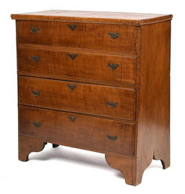
SoldAmerican Queen Anne Figured Walnut High ChestNew England, 18th century, upper case with map drawer over four graduated long drawers, lower case with two long drawers and cabriole legs, dovetailed construction, white pine secondary, 67-1/4 x 35 xSee Sold Price
SoldEarly American East Coast Map, Willem BleauWillem Janszoon Blaeu (Dutch, 1571-1638). Two conjoined pages to form the single map depicting New Netherlands and New England, with Manhattan and the coast of Long Island. Embellished with ships, figSee Sold Price
SoldTwo Antique MapsTwo Antique Maps. Map of United States and Texas, dated 1839 by Daniel Burgess and a Map of Mexico Central America and the West Indies, dated 1867 by S Augustus Mitchell.See Sold Price
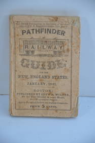
Pathfinder Railway Guide for the New England States-January 1851JM Hobby Supply and Railroad Artifact Auctions4.4(126)See Sold PriceFeb 24, 2024
Lehigh and New England RR 6-Pack Athearn 34 Foot 2 Bay Hoppers-HO Scale-New in BoxJM Hobby Supply and Railroad Artifact Auctions4.4(126)See Sold PriceFeb 25, 2024
CHIPPENDALE TIGER MAPLE SLANT LID DESKThomaston Place Auction Galleries4.4(386)See Sold PriceFeb 24, 2024
PORTRAIT OF A NEW ENGLAND GENTLEMAN, CA 1810Thomaston Place Auction Galleries4.4(386)See Sold PriceFeb 24, 2024
Chanel Burgundy Leather Double Flap BagDOYLE Auctioneers & Appraisers4.6(166)See Sold PriceFeb 29, 2024
Chanel Beige Quilted Calfskin Small Double Flap BagDOYLE Auctioneers & Appraisers4.6(166)See Sold PriceFeb 29, 2024
1849 THE NEW-ENGLAND MERCANTILE UNIONNorth American Artifact Auctions4.6(182)See Sold PriceApr 20, 2024
[MAP]. [ALBRIZZI, Giambatista, 1698-1777]. Carta Geografica...Potter & Potter Auctions4.6(539)See Sold PriceMar 07, 2024
1803 NARRATIVE OF INDIAN WARS IN NEW-ENGLAND antique Stockbridge AMERICANAJasper524.5(9.8k)See Sold PriceFeb 27, 2024
Two Hand-Colored 19th Century Maps of New Orleans and Louisiana, Larger- H.- 12 1/2 in., W.- 15 1/2Crescent City Auction Gallery4.3(229)See Sold PriceMar 08, 2024
Late 18th century map of England and Wales sampler and two printsFellows4.3(159)See Sold PriceMar 05, 2024
Jules Verne, L'Archipel en Feu, Au Steamer Red MacaronLion and Unicorn4.7(1.8k)See Sold PriceMar 10, 2024
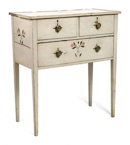
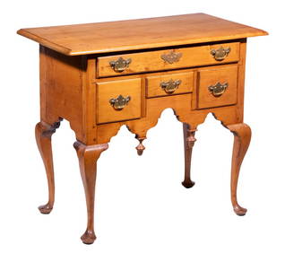
FINE FEDERAL NEW ENGLAND PAINT DECORATED SERVER.William Smith Auctions4.6(146)See Sold PriceMar 06, 2024
18TH C. QUEEN ANNE TIGER MAPLE BLANKET CHEST.William Smith Auctions4.6(146)See Sold PriceMar 06, 2024
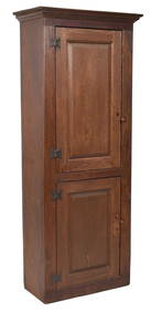
18TH C. NEW ENGLAND RED STAINED CHIMNEY CUPBOARD.William Smith Auctions4.6(146)See Sold PriceMar 06, 2024
FEDERAL NEW ENGLAND INLAID MAHOGANY SIDEBOARD.William Smith Auctions4.6(146)See Sold PriceMar 06, 2024
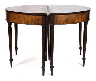
19TH C. NE TIGER MAPLE & CHERRY BANQUET TABLE.William Smith Auctions4.6(146)See Sold PriceMar 06, 2024


![[Map]. 1857 J. H. Colton Pocket Map of Texas. Ne (1 of 2)](https://p1.liveauctioneers.com/906/165466/83729356_1_x.jpg?height=282&quality=70&version=1586352505)


![[MAP]. [ALBRIZZI, Giambatista, 1698-1777]. Carta Geografica... (1 of 1)](https://p1.liveauctioneers.com/928/318880/171361280_1_x.jpg?height=282&quality=70&version=1707501302)