ATLAS of ANTIENT GEOGRAPHY by SAMUEL BUTLER 1843John McInnis Auctioneers,LLC4.6(502)See Sold PriceFeb 24, 2024
18TH C. ANTIQUE MAP: FRENCH & INDIAN WAR, FRAMEDThomaston Place Auction Galleries4.4(386)See Sold PriceFeb 24, 2024
Rand McNally Railroad Map Cabinet w/ 21 Railroad MapsRail & Road Auctions4.6(165)See Sold PriceMar 08, 2024
Keith Haring - Ink on New York Map, Best Buddies, Inscribed, Signed, and DatedSapphire Auction Gallery4(67)See Sold PriceMar 02, 2024
LATE 17TH C. FRENCH MAP OF THE NEW WORLD BY ALEXIS-HUBERT JAILLOT (1632-1712)Thomaston Place Auction Galleries4.4(386)See Sold PriceFeb 24, 2024
Central Railroad of New Jersey Map of Sandy Hook Route-ca. 1903JM Hobby Supply and Railroad Artifact Auctions4.4(126)See Sold PriceFeb 24, 2024
Lot of Six Mixed Atlas Box Cars-HO Scale-New in BoxJM Hobby Supply and Railroad Artifact Auctions4.4(126)See Sold PriceFeb 25, 2024
Rand McNally/Santa Fe Railroad Map of Iowa-1912JM Hobby Supply and Railroad Artifact Auctions4.4(126)See Sold PriceFeb 24, 2024
NICOLAES VISSCHER (NETHERLANDS, 1618-1709) MAP OF THE NEW WORLDThomaston Place Auction Galleries4.4(386)See Sold PriceFeb 24, 2024
17TH C. WORLD MAP BY NICOLAES VISSCHER (NETHERLANDS, 1618-1709)Thomaston Place Auction Galleries4.4(386)See Sold PriceFeb 24, 2024
Lot of Six Mixed Atlas Cabooses-HO Scale-New in BoxJM Hobby Supply and Railroad Artifact Auctions4.4(126)See Sold PriceFeb 25, 2024
SoldTwo Maps; Unknown, "Charte von den NordwestkusteTwo Maps; Unknown, "Charte von den Nordwestkuste Americas Nach Vancouver," Prague, 1818, H. - 10 in., W. - 8 in.; together with Unknown, "Charte der neuen Niederlassungen in Ober Canada each der mythsSee Sold Price
SoldTwo Maps by Friedrich Wilhelm Streit, "Charte vonTwo Maps by Friedrich Wilhelm Streit, "Charte von America Nach den neuesten Materialen Sichersten Ortbestimmungen and der neuesten Entheilung entworfen," together with "Nord America Und West Indien,"See Sold Price
SoldTwo maps of the Sandwich Islandsincluding Charte von den Sandwich Inseln by James Cook (1728- 1779), published in Des Capitan Jacob Cook's dritte Entdeckungsreise, 1788, depicting Cook's route through the Sandwich Islands/Hawaii, wiSee Sold Price
SoldUnknown, "Charte von den Vereinigten Staaten for NordUnknown, "Charte von den Vereinigten Staaten for Nord America mit Louisiana," Prague, 1818, H. - 13 1/2 in., W. - 17 3/4 in.See Sold Price
SoldMAP - Charte von Den Vereinigten Staaten von NordMAP - GÜSSEFELD, Franz Ludwig. Charte von Den Vereinigten Staaten von Nord-America nebst Louisiana.Weimar: 1805. Hand-colored double-page engraved map printed on light green paper (530x700 mmSee Sold Price
SoldUnknown, "Charte von America nach den Neusten BerichtenUnknown, "Charte von America nach den Neusten Berichten und Entdeckungen entworfen," Prague, 1818, H. - 18 in., W. - 12 5/8 in.See Sold Price
Geographisches Institut: Antique Map West Indies, 1814Map: Charte von West Indien oder den Antillischen Inseln Cartographer: Verlage des Geograph. Instituts Place & Date: Weimar / 1814 Size: 16"x 12" Condition: outline color; overall age toning and someSee Sold Price
SoldGeograph. Institut: Caribbean Isles/BahamasMap: Charte von West Indien oder den Antillischen Inseln Cartographer: Verlage des Geograph. Instituts Place & Date: Weimar / 1814 Size: 16"x 12" Condition: outline color; overall age toning and someSee Sold Price
SoldTWO MAPS OF THE WESTERN HEMISPHERE. Charte von America and Charte von Nord-America. Prague, 1818.TWO MAPS OF THE WESTERN HEMISPHERE. Charte von America and Charte von Nord-America. Prague, 1818. Two engraved maps with hand coloring, matted and framed, one showing North and South America and one sSee Sold Price
SoldGrp: 6 Maps of SpainGroup of six maps of France and Spain. Includes Friedrich Wilhelm Streit (1772-1839) map of France "Charte von Frankreich nach den besten Hulfsmitteln," Nuremberg, 1815; Guillaume Delisle (1675-1726)See Sold Price
SoldScarce German map of United States in 1805Heading: Author: Güssefeld, Franz Ludwig Title: Charte von Den Vereinigten Staaten von Nord-America nebst Louisiana... Place Published: Weimar Publisher:Verlage des Geograph Instituts Date PubliSee Sold Price
Pluth Map of North AmericaPLUTH, Franz (1800-1871).Charte von den Vereninigten Staaten von Nord America mit Louisiana.Engaraved map with hand color in outline.Prague, 1818.13 1/4" x 17 5/8" sheet.The present map is Pluth's modSee Sold Price
Goetze: Charte von Sicilien und Malta, 1801Map: Charte von Sicilien und Malta Cartographer: Goetze Place & Date: Weimar / 1801 Size: 22" x 17 1/4" Condition: wash color; overall age toning, some spotting, mostly in margins; two small holes inSee Sold Price
SoldTwo framed 18th century hand colored engraved mapsTwo framed 18th century hand colored engraved maps including Schwaben Circulus Sueviae Continens ducatum Wirtenbergensen, 18th century map and Charte von dem Königreich PreuBen 1795.See Sold Price
SoldKIPFERLING, KARL JOSEPH. Charte von Westindien denKIPFERLING, KARL JOSEPH. Charte von Westindien den Vereinigten Staaten und Einem Theile von Sud America. Engraved map of post-Louisiana Purchase North America showing political borders delineated in oSee Sold Price
Goetze: Sicily with Maltese Islands Inset, 1801Map Title: Charte von Sicilien und MaltaCartographer: Goetze Place/Date: Weimar / 1801 Size: 22" x 17 1/4" Condition: wash color; overall age toning, some spotting, mostly in margins; two small holesSee Sold Price
Homann Map of Asia*** START PRICE IS THE RESERVE *** [Asia] HOMANN, Johann Baptiste (1664-1724). Charte von Asien Nach den bewahrtesten... Engraved map with original hand color in outline. Nurenberg: 1793. 21 1/2" x 25See Sold Price
SoldGerman map of North America 1807Heading: Author: Walch, Johann Title: Charte von Nordamerica nach den neusten Entdeckungen und zuverlässigsten astronomischen Ortsbestimmungen entworfen Place Published: Augsburg Publisher: DateSee Sold Price
SoldGerman map of Americas 1800Title: Charte von America, Nac den neuesten Entdeckungewn und astronomischen Ortsbestimmunden berichliget und geseichnet Author: Reinecke, Johann Matthais Christoph Description: Copper-engraved map, hSee Sold Price
Gerrman map of Americas 1810Title: Charte von America nach den Neuesten Materialen... Author: Streit, Friedrich Wilhelm Description: Copper-engraved map, hand-colored in outline. 58x47 cm. (23x18½").North and South America withSee Sold Price
Gerrman map of Americas 1810Title: Charte von America nach den Neuesten Materialen... Author: Streit, Friedrich Wilhelm Description: Copper-engraved map, hand-colored in outline. 58x47 cm. (23x18½").North and South America withSee Sold Price
SoldGerrman map of Americas 1810Title: Charte von America nach den Neuesten Materialen... Author: Streit, Friedrich Wilhelm Description: Copper-engraved map, hand-colored in outline. 58x47 cm. (23x18½").North and South America withSee Sold Price
SoldReichard, Charte von Nordamerica, 1804.[North America]. C.G. Reichard. Charte Von Nordamerica Nach Den Neuesten Bestimmungen Und Entdeckungen. Weimar Geographical Institute, August, 1804. Double-page engraved map, early outline hand-coloriSee Sold Price
SoldReichard's North America with Franklin 1802Title: Charte von Nordamerica nach den Neuesten Bestimmungen und Entdeckungen Author: Reichard, Christian Gottlieb Theophil Description: Copper-engraved map, hand-colored. 59x51.5 cm. (23¼x20¼").MapSee Sold Price
Cleveland and Mahoning RR 2nd Annual Report-December 20, 1854JM Hobby Supply and Railroad Artifact Auctions4.4(126)See Sold PriceFeb 24, 2024
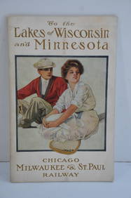
Chicago Milwaukee and St Paul RY To the Lakes of Wisconsin and Minnesota Book-1909JM Hobby Supply and Railroad Artifact Auctions4.4(126)See Sold PriceFeb 24, 2024
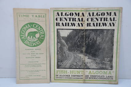
Algoma Central RY March 12, 1944 Public Timetable and BrochureJM Hobby Supply and Railroad Artifact Auctions4.4(126)See Sold PriceFeb 24, 2024
MARTINET / DE VRIES Catechism of Nature 4 Vol. Set c1788 Engravings Rare!Luis Porretta Fine Arts4.3(10)See Sold PriceMar 02, 2024
GOERG OTT 1861 Religious Legends German Language With WoodcutsLuis Porretta Fine Arts4.3(10)See Sold PriceMar 02, 2024
Jerusalem Map for British Soldiers in Palestine - WW2Levy Auction House4.3(11)See Sold PriceFeb 27, 2024
18 Booklets Collection - War Graves of Palestine - WWILevy Auction House4.3(11)See Sold PriceFeb 27, 2024
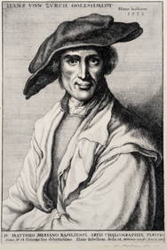
Wenceslaus Hollar. Portraits. To include: Hans von Zurch Goltshmidt, Frans van den Wyngarde,Tremont Auctions4.6(293)See Sold PriceFeb 25, 2024
Willem Blaeu, Etc. 17th C. Antiquarian Maps, 2Auctions at Showplace4.5(726)See Sold PriceMar 17, 2024
GEORGE ANDREW CORLEY (DATES UNKNOWN) U.S. TEAM SKI TRYOUTS / MT. HOOD OREGON. 1939.Swann Auction Galleries4.4(65)See Sold PriceFeb 29, 2024
Two Hand-Colored 19th Century Maps of New Orleans and Louisiana, Larger- H.- 12 1/2 in., W.- 15 1/2Crescent City Auction Gallery4.3(229)See Sold PriceMar 08, 2024
THE ANTIQUE ILLUSTRATED BOOK "1856 ARCTIC EXPLORATIONS: SECOND GIRNEL EXPEDITION 2" BY E. KANENY Elizabeth 4.3(84)See Sold PriceMar 03, 2024
Three Chinese fan paintings, by Din Shoukui (Chinese), Zhou Bin (Chinese), and an unknown artistOakridge Auction Gallery4.5(190)See Sold PriceMar 17, 2024