ATLAS of ANTIENT GEOGRAPHY by SAMUEL BUTLER 1843John McInnis Auctioneers,LLC4.6(502)See Sold PriceFeb 24, 2024
18TH C. ANTIQUE MAP: FRENCH & INDIAN WAR, FRAMEDThomaston Place Auction Galleries4.4(386)See Sold PriceFeb 24, 2024
Rand McNally Railroad Map Cabinet w/ 21 Railroad MapsRail & Road Auctions4.6(165)See Sold PriceMar 08, 2024
Keith Haring - Ink on New York Map, Best Buddies, Inscribed, Signed, and DatedSapphire Auction Gallery4(67)See Sold PriceMar 02, 2024
LATE 17TH C. FRENCH MAP OF THE NEW WORLD BY ALEXIS-HUBERT JAILLOT (1632-1712)Thomaston Place Auction Galleries4.4(386)See Sold PriceFeb 24, 2024
Central Railroad of New Jersey Map of Sandy Hook Route-ca. 1903JM Hobby Supply and Railroad Artifact Auctions4.4(126)See Sold PriceFeb 24, 2024
Lot of Six Mixed Atlas Box Cars-HO Scale-New in BoxJM Hobby Supply and Railroad Artifact Auctions4.4(126)See Sold PriceFeb 25, 2024
Rand McNally/Santa Fe Railroad Map of Iowa-1912JM Hobby Supply and Railroad Artifact Auctions4.4(126)See Sold PriceFeb 24, 2024
NICOLAES VISSCHER (NETHERLANDS, 1618-1709) MAP OF THE NEW WORLDThomaston Place Auction Galleries4.4(386)See Sold PriceFeb 24, 2024
17TH C. WORLD MAP BY NICOLAES VISSCHER (NETHERLANDS, 1618-1709)Thomaston Place Auction Galleries4.4(386)See Sold PriceFeb 24, 2024
Lot of Six Mixed Atlas Cabooses-HO Scale-New in BoxJM Hobby Supply and Railroad Artifact Auctions4.4(126)See Sold PriceFeb 25, 2024
SoldTwo Maps of the Holy LandLot of two maps of the Holy Land: *"Terrae Sanctae 2". Copperplate engraving. Paris: Lattre & Delalain,1782. Authors: Guillaume de l'Isle and Joseph Nicolas de l'Isle. Dimensions of plate: 34X48.5 cm.See Sold Price
SoldPromised Land Map LotLot of two maps of the Holy Land: 1. "A map of the Land of Promise Compiled by the Author out of the Book of Joshua". Hand-colored copperplate engraving. From: Calmet, Augustin Antoine. A historical,See Sold Price
Sold(MAP) ORTELIUS, ABRAHAM Size of frame 20 x 26 1/4 i(MAP) ORTELIUS, ABRAHAM A group of two maps of the Holy Land and surrounding Mediterranean. (Antwerp, c. 1580). Hand-colored. Framed and matted. Palestinae sive totius terrae promissionis nova descripSee Sold Price
SoldTwo Antique Maps of the Holy LandLot of two antique maps of the Holy Land: *Pictorial representation of the wandering of the Jews in the desert: "Voyages des Enfants d’Israel Dans le Desert depuis leur sortie d’Egypte PSee Sold Price
Sold(HOLY LAND.) Fer, Nicolas de. Descriptio Acurata Terrae(HOLY LAND.) Fer, Nicolas de. Descriptio Acurata Terrae Promissae per Sortes XII / Terre Sainte Moderne. Double-page sheet with two engraved maps contrasting the Holy Land region in ancient and modernSee Sold Price
Fuller (Thomas) The Holy LandFuller (Thomas) The Holy Land,two maps from A Pisgah-Sight of Palestine, each with ornamental title and scale cartouches, each with pairs of compasses, engraved maps, each 280 x 335mm., each wSee Sold Price
SoldTwo ca. 1700 Dutch Maps of the Holy LandLot of two antique maps of the holy land: *"Het Beloofde Landt Canaan door wandelt van onsen Salichmaecker Jesu Christo neffens syne Apostelen". Copperplate engraving. From: Biblia..., Dordrecht and ASee Sold Price
SoldTwo Framed Hand-colored Maps of the Holy Land, a pTwo Framed Hand-colored Maps of the Holy Land, a page titled Of Canaan, and a Guillelmi De L'Isle and Josepho N. De L'Isle Terrae Santae Tabula, the latter sight size 13 1/2 x 19 1/4 in.See Sold Price
Two atlases with maps of the Holy Land. Start of theTwo atlases with maps of the Land of Israel, London and New York prints. *Â Atlas of the Historical Geography of the Holy Land. Edited by George Adam Smith. London, 1915. 60 colored geographical mapSee Sold Price
SoldH.B. Tristram - The Land of Israel, a Journal ofTwo Palestine Travel Books, London, 1862-1865. Including: 1. H.B. Tristram - The Land of Israel, a Journal of Travels in Palestine, London, 1865. Including two maps: 1. Routes in the holy Land,See Sold Price
SoldWright, Paul 1782 Holy Land Map. Apostles Travels etcTwo maps on one sheet by Thomas Conder "A Map of the Countries where the Apostles Travell'd…" and "A Map of the more remote Places mentioned in the New Testament" Folio Copper Plate Published 1782,See Sold Price
SoldYOUR GUIDE TO THE HOLY LAND, 1941Guide to the Holy Land by Fareed Imam. Jerusalem, 1941. English. Many photos, including two folded maps.The Muslim author included his photo. Soft, printed cover with a picture pasted to it. Fine condSee Sold Price
Norov, Abraham «Journey to Holy Land in 1835»2nd ed. In 2 parts. St. Petersburg, 1844. 25,3x16,5 cm. Text in Russian. A complete set of engraved illustrations, lithographed map. Two half-leather bindings. In 1st part there is one additional engrSee Sold Price
Sold(HOLY LAND.) Janssonius, Johannes. Judaeae seu Terrae(HOLY LAND.) Janssonius, Johannes. Judaeae seu Terrae Israelis Tabula Geographica. Double-page engraved map of the Holy Land with two decorative figural cartouche designs. 18¾x22¾ inches sheSee Sold Price
Sold(HOLY LAND.) Homann, Johann Baptist. Judaea seu(HOLY LAND.) Homann, Johann Baptist. Judaea seu Palaestina ob Sacratissima Redemtoris Vestigia Hodie Dicta Terra Sancta. Double-page engraved map of the Holy Land with two decorative vignette cartouchSee Sold Price
SoldMiddle East.- Cassini (Giovanni Maria) Gli ImperiMiddle East.- Cassini (Giovanni Maria) Gli Imperi Antichi Parte Occidentale; Gli Imperi Antichi Parte Orientale, two part map of the Turkish Empire, showing Greece, Asia Minor, the Holy Land, Egypt, tSee Sold Price
Sanson (Nicolas) Terra Promissa, sive JudaeaSanson (Nicolas) Terra Promissa, sive Judaea,engraved map of the Holy Land, on two sheets, joined, hand-coloured, decorative title cartouche, 380 x 500mm., one repair to the upper left side, PSee Sold Price
Maps of the Holy Land. Images of Terra SanctaTitle: Maps of the Holy Land. Images of Terra Sancta through Two Millennia. New York. Abbeville Press. 1986 Author(s): Nebenzahl, Kenneth First edition. Condition: Fine copy in fine dust jacket (in mySee Sold Price
SoldMaps of the Holy Land Images of Terra SanctaMaps of the Holy Land. Images of Terra Sancta through Two Millennia. Nebenzahl, Kenneth. Abbeville Press. First edition. Folio. Illustrated in black, white and color. Shipping: Domestic: Flat-rate ofSee Sold Price
SoldTwo books of maps of Eretz Israel: 1. Jerusalem, theTwo books of maps of Eretz Israel: 1. Jerusalem, the saga of the Holy City, The Universitas publ Jlm 1954 no 947 of limited ed 2. Holy Land in maps, ed A. Tishby, The Il Museum Jlm 2001See Sold Price
SoldAntique Map of the Holy Land \\\"Terra Sancta quae inAntique Map of the Holy Land \\\"Terra Sancta quae in Sacris Terra Promissionis Olim Palestina\\\", Janszoon Blaeu, 1629Includes large cartouche, two compass roses, sea monsters and other embellishmenSee Sold Price
SoldGroup of six maps of the Holy Lands, four are 14.Group of six maps of the Holy Lands, four are 14.25”x18.5” and two are hand-colored 8”x10”See Sold Price
SoldSitus Terrae Promissionis, Cologne, 1590Map of the Holy Land: "Situs Terrae Promissionis SS Bibliorum Intelligentiam Exacte Aperiens: Per Christianum Adrichomium Delphum". Latin. Printed on two sheets joined together. Copperplate engraving.See Sold Price
SoldHoly Land.- Sanson (Nicolas) Judaea seu Terra SanctaHoly Land.- Sanson (Nicolas) Judaea seu Terra Sancta quae Hebraeorum sive Israelitarum, large map of the Holy Land divided into tribes, engraving with some early hand-colouring, on two sheets conjoineSee Sold Price
DAVID ROBERTS - Holy Land / Syria / Egypt etc. 3 x Folio Volumes 1849 Very RareLuis Porretta Fine Arts4.3(10)See Sold PriceMar 02, 2024
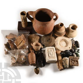
Large Holy Land Terracotta Storage Jar with Pie-Crust HandlesTimeLine Auctions Ltd.4.5(183)See Sold PriceMar 07, 2024
Jerusalem Map for British Soldiers in Palestine - WW2Levy Auction House4.3(11)See Sold PriceFeb 27, 2024
Collection of 10 Maps of Cities in Israel for TouristsLevy Auction House4.3(11)See Sold PriceFeb 27, 2024
Two booklets - Diskin Orphanage, Jerusalem, PalestineLevy Auction House4.3(11)See Sold PriceFeb 27, 2024
18 Booklets Collection - War Graves of Palestine - WWILevy Auction House4.3(11)See Sold PriceFeb 27, 2024
Two Silver Souvenir Spoons - Jerusalem - 19th centuryLevy Auction House4.3(11)See Sold PriceFeb 27, 2024
Two Porcelain Plates - Nordau Plaza Hotel Tel AvivLevy Auction House4.3(11)See Sold PriceFeb 27, 2024
1849 Mitchell School ATLAS 24 MAPS America Holy Land France Africa Egypt AsiaSchilb Antiquarian Rare Books4.8(421)See Sold PriceMar 31, 2024
1872 Holy BIBLE & Hitchcock Analysis Gruden Concordance Theology MAPS Holy LandSchilb Antiquarian Rare Books4.8(421)See Sold PriceMar 31, 2024
TWO ANTIQUE JEWISH NATIONAL FUND CHARITY BOXES. The first one made in Berlin c. 1920J. Greenstein & Co., Inc.4.3(55)See Sold PriceApr 16, 2024
A GROUP OF TWO EARLY BLACK AND WHITE HOLY LAND PHOTOGRAPHS BY AMERICAN COLONY PHOTOGRAPHERS.J. Greenstein & Co., Inc.4.3(55)See Sold PriceApr 16, 2024