ATLAS of ANTIENT GEOGRAPHY by SAMUEL BUTLER 1843John McInnis Auctioneers,LLC4.5(505)See Sold PriceFeb 25, 2024
18TH C. ANTIQUE MAP: FRENCH & INDIAN WAR, FRAMEDThomaston Place Auction Galleries4.4(393)See Sold PriceFeb 24, 2024
Rand McNally Railroad Map Cabinet w/ 21 Railroad MapsRail & Road Auctions4.6(165)See Sold PriceMar 08, 2024
Keith Haring - Ink on New York Map, Best Buddies, Inscribed, Signed, and DatedSapphire Auction Gallery4(67)See Sold PriceMar 02, 2024
LATE 17TH C. FRENCH MAP OF THE NEW WORLD BY ALEXIS-HUBERT JAILLOT (1632-1712)Thomaston Place Auction Galleries4.4(393)See Sold PriceFeb 24, 2024
Central Railroad of New Jersey Map of Sandy Hook Route-ca. 1903JM Hobby Supply and Railroad Artifact Auctions4.4(127)See Sold PriceFeb 24, 2024
Lot of Six Mixed Atlas Box Cars-HO Scale-New in BoxJM Hobby Supply and Railroad Artifact Auctions4.4(127)See Sold PriceFeb 25, 2024
Rand McNally/Santa Fe Railroad Map of Iowa-1912JM Hobby Supply and Railroad Artifact Auctions4.4(127)See Sold PriceFeb 24, 2024
NICOLAES VISSCHER (NETHERLANDS, 1618-1709) MAP OF THE NEW WORLDThomaston Place Auction Galleries4.4(393)See Sold PriceFeb 24, 2024
17TH C. WORLD MAP BY NICOLAES VISSCHER (NETHERLANDS, 1618-1709)Thomaston Place Auction Galleries4.4(393)See Sold PriceFeb 24, 2024
Lot of Six Mixed Atlas Cabooses-HO Scale-New in BoxJM Hobby Supply and Railroad Artifact Auctions4.4(127)See Sold PriceFeb 25, 2024
SoldTwo Maps by Samuel Augustus Mitchell (1790-1868), "MapTwo Maps by Samuel Augustus Mitchell (1790-1868), "Map of North America," No. 4, 1852, hand colored, H. -11 1/2 in., W. - 9 1/8 in. (2 Pcs.)See Sold Price
SoldTwo Maps by Samuel Augustus Mitchell (1790-1868),Two Maps by Samuel Augustus Mitchell (1790-1868), consisting of "Western Hemisphere", 1874, hand colored, H. -15 1/4 in., W. - 11 3/4 in.; together with "Eastern Hemisphere", 1884, hand colored, H. -1See Sold Price
SoldTwo Maps by Samuel Augustus Mitchell (1790-1868),Two Maps by Samuel Augustus Mitchell (1790-1868), "United States and Territories together with Canada," 1860," hand colored, H.-15 1/4 in., W.- 23 1/8 in. (2 Pcs.)See Sold Price
SoldTwo Maps by Samuel Augustus Mitchell (1790-1868), "MapTwo Maps by Samuel Augustus Mitchell (1790-1868), "Map of the Western States and Chief Parts of the SouthernStates," 1852, hand colored, H.-11/2 in., W.- 17 1/2 in., and 11 5/8 in., W.- 18 in.See Sold Price
SoldThree Maps by Samuel Augustus Mitchell (1790-1868), "Three Maps by Samuel Augustus Mitchell (1790-1868), " County Maps of Arkansas, Louisiana and Mississippi, Verso with Florida, and a Plan of New Orleans" 1882, hand colored, on two pages, H.-24 in., W.See Sold Price
SoldTwo Copies of Samuel Augustus Mitchell (1790-1868),Two Copies of Samuel Augustus Mitchell (1790-1868), "Map of the United States," 1877, H. - 11 1/2 in., W. -15 in. (2 Pcs.)See Sold Price
SoldTwo Copies of Samuel Augustus Mitchell (1790-1868), "Two Copies of Samuel Augustus Mitchell (1790-1868), " County Map of Arkansas, Mississippi, and Louisiana," 1870, hand colored, H.-15 1/8 in., W.- 23 1/8 in. (2 Pcs.)See Sold Price
SoldSAMUEL AUGUSTUS MITCHELL (AMERICAN,1790-1868) FOLDINGSAMUEL AUGUSTUS MITCHELL (AMERICAN,1790-1868) FOLDING MAPS OF THE UNITED STATES, SET OF TWO, hand-colored, cover stamped "MITCHELL'S NATIONAL MAP OF THE UNITED STATES.", comprising "MITCHELL'S NationaSee Sold Price
SoldSAMUEL AUGUSTUS MITCHELL (AMERICAN,1790-1868) FOLDINGSAMUEL AUGUSTUS MITCHELL (AMERICAN,1790-1868) FOLDING MAPS OF THE UNITED STATES, SET OF TWO, one hand-colored, comprising "Mitchell's National Map of the American Republic", full title "MITCHELL'S NatSee Sold Price
SoldThree Maps by Samuel Augustus Mitchell (1790-1868),Three Maps by Samuel Augustus Mitchell (1790-1868), "County Map of England and Wales," 1860, hand colored, H.-15 3/8 in., W.- 12 1/8 in. (3 Pcs.)See Sold Price
SoldTwo Copies of Samuel Augustus Mitchell (1790-1868),Two Copies of Samuel Augustus Mitchell (1790-1868), "Northern Portion of New York City and Brooklyn County," 1880, hand colored, H.-15 1/4 in., W.- 24 1/4 in. (2 Pcs.)See Sold Price
SoldTwo Copies of Samuel Augustus Mitchell (1790-1868),Two Copies of Samuel Augustus Mitchell (1790-1868), "Plan of New Orleans," 1867, hand colored, H. -11 3/4 in., W. - 15 1/8 in.See Sold Price
Sold(6) MITCHELL & BRADLEY ATLAS MAPS NEW YORK, BOSTON(lot of 6) Unframed atlas maps, Samuel Augustus Mitchell (United States, 1790-1868), c.1884, approx 15.25"h, 23.25"w, including: (1) plan of Boston, with inset of Boston Harbor, (1) plan of the city oSee Sold Price
(4) MITCHELL ATLAS MAPS, PANAMA CANAL, C.1884(lot of 4) Unframed atlas maps, Samuel Augustus Mitchell (United States, 1790-1868), c.1884, including: (1) North and South Carolina, with inset map of Charleston harbor and plan of Charleston, 12.5"hSee Sold Price
(4) MITCHELL ATLAS MAPS, KANSAS, OHIO, MICHIGAN(lot of 4) Unframed atlas maps, Samuel Augustus Mitchell (United States, 1790-1868), drawn and engraved by William H. Gamble (United States, 1827-1892), including: (1) County map of Minnesota, c.1884,See Sold Price
SoldSamuel Augustus Mitchell (1790-1868), "Map of NorthSamuel Augustus Mitchell (1790-1868), "Map of North America," 1852, H. - 11 1/2 in., W. - 9 in.See Sold Price
SoldSamuel Augustus Mitchell (1790-1868), "Map of the StateSamuel Augustus Mitchell (1790-1868), "Map of the State of Texas," 1852, No. 13, hand colored, H. -9 in., W. - 15 3/8 in.See Sold Price
Samuel Augustus Mitchell (1790-1868), "Map ofSamuel Augustus Mitchell (1790-1868), "Map of Pennsylvania," 1871, H. - 15 1/8 in., W. -23 in. (2 Pcs.)See Sold Price
Samuel Augustus Mitchell (1790-1868), " Map of theSamuel Augustus Mitchell (1790-1868), " Map of the Chief Parts of the Western States including Western Virginia," 1852, hand colored, H.-11 3/4 in., W.-18 3/8 in.See Sold Price
SoldSamuel Augustus Mitchell (1790-1868), "Map of theSamuel Augustus Mitchell (1790-1868), "Map of the United States," 1852, hand colored, H.-11 1/4 in., W.- 18 in.See Sold Price
SoldThree Copies of Samuel Augustus Mitchell (1790-1868),Three Copies of Samuel Augustus Mitchell (1790-1868), "Map of the Chief part of the Southern States and Part of the Western States," 1851, H. - 15 1/8 in., W. -23 in. (3 Pcs.)See Sold Price
SoldSamuel Augustus Mitchell (1790-1868), "County Map ofSamuel Augustus Mitchell (1790-1868), "County Map of the States of Georgia and Alabama," 1860, H.- 12 1/4 in., W.- 15 3/8 in.See Sold Price
SoldSamuel Augustus Mitchell (1790-1868), "County Map ofSamuel Augustus Mitchell (1790-1868), "County Map of the State of Illinois," 1861, hand colored, H.-15 1/4 in., W.- 12 3/8in.See Sold Price
SoldSamuel Augustus Mitchell (1790-1868), "County Map ofSamuel Augustus Mitchell (1790-1868), "County Map of Florida," 1867, Atlas, with an inset of Mobile, H.- 12 in., W.- 12 3/8 in.See Sold Price
Cleveland and Mahoning RR 2nd Annual Report-December 20, 1854JM Hobby Supply and Railroad Artifact Auctions4.4(127)See Sold PriceFeb 24, 2024
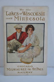
Chicago Milwaukee and St Paul RY To the Lakes of Wisconsin and Minnesota Book-1909JM Hobby Supply and Railroad Artifact Auctions4.4(127)See Sold PriceFeb 24, 2024
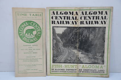
Algoma Central RY March 12, 1944 Public Timetable and BrochureJM Hobby Supply and Railroad Artifact Auctions4.4(127)See Sold PriceFeb 24, 2024
Frederick Carl Smith (CA,DC,OH,Norway,1868-1955) oil paintingBroward Auction Gallery4.7(292)See Sold PriceMar 17, 2024
SAMUEL AYSCOUGH Remarkable Passages In Shakespeare 1st 1790 Edition Full CalfLuis Porretta Fine Arts4.3(10)See Sold PriceMar 02, 2024
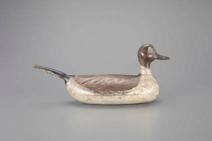
Pintail Drake Decoy by Samuel Hockings Sr. (1868-1950)Copley Fine Art Auctions4.5(40)See Sold PriceFeb 24, 2024
1849 Mitchell School ATLAS 24 MAPS America Holy Land France Africa Egypt AsiaSchilb Antiquarian Rare Books4.8(428)See Sold PriceMar 31, 2024
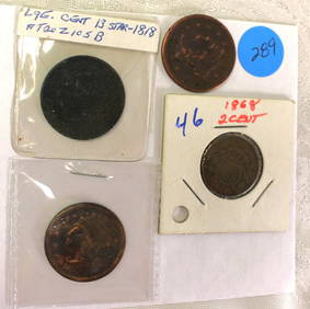
4 US coins: rare 1868 two cent piece & 3 large cents 1855 1851 and 13 star 1818South Jersey Auction by Babington Auction Inc4.6(124)See Sold PriceFeb 25, 2024
Early 1990s Chicago Transit Authority Fiberglass Line MapRail & Road Auctions4.6(165)See Sold PriceMar 08, 2024
Judson Tunison American Landscape Watercolor PaintingNapoleon's Fine Art4.4(75)See Sold PriceFeb 25, 2024
Willem Blaeu, Etc. 17th C. Antiquarian Maps, 2Auctions at Showplace4.6(740)See Sold PriceMar 17, 2024
Mitchell - Map of the City of Washington (Washington, DC)Trillium Antique Prints & Rare Books4.5(32)See Sold PriceFeb 24, 2024
Two Hand-Colored 19th Century Maps of New Orleans and Louisiana, Larger- H.- 12 1/2 in., W.- 15 1/2Crescent City Auction Gallery4.3(231)See Sold PriceMar 08, 2024
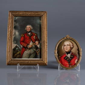
ANTIQUE PORTRAIT MINIATURES OF LORD HEATHFIELDPridham's Auctions & Appraisals4.7(223)See Sold PriceMar 02, 2024
THE ANTIQUE ILLUSTRATED BOOK "1856 ARCTIC EXPLORATIONS: SECOND GIRNEL EXPEDITION 2" BY E. KANENY Elizabeth 4.2(86)See Sold PriceMar 03, 2024
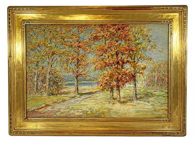
Lg. Watercolor Painting, Judson Samuel Tunison.Direct Auction Galleries 4.7(337)See Sold PriceFeb 24, 2024
SAMUEL LOVER MINIATURE PORTRAIT OF YOUNG WOMAN.William Smith Auctions4.6(147)See Sold PriceMar 06, 2024