ATLAS of ANTIENT GEOGRAPHY by SAMUEL BUTLER 1843John McInnis Auctioneers,LLC4.5(505)See Sold PriceFeb 24, 2024
18TH C. ANTIQUE MAP: FRENCH & INDIAN WAR, FRAMEDThomaston Place Auction Galleries4.4(393)See Sold PriceFeb 24, 2024
Rand McNally Railroad Map Cabinet w/ 21 Railroad MapsRail & Road Auctions4.6(165)See Sold PriceMar 08, 2024
Keith Haring - Ink on New York Map, Best Buddies, Inscribed, Signed, and DatedSapphire Auction Gallery4(67)See Sold PriceMar 02, 2024
LATE 17TH C. FRENCH MAP OF THE NEW WORLD BY ALEXIS-HUBERT JAILLOT (1632-1712)Thomaston Place Auction Galleries4.4(393)See Sold PriceFeb 24, 2024
Central Railroad of New Jersey Map of Sandy Hook Route-ca. 1903JM Hobby Supply and Railroad Artifact Auctions4.4(127)See Sold PriceFeb 24, 2024
Lot of Six Mixed Atlas Box Cars-HO Scale-New in BoxJM Hobby Supply and Railroad Artifact Auctions4.4(127)See Sold PriceFeb 25, 2024
Rand McNally/Santa Fe Railroad Map of Iowa-1912JM Hobby Supply and Railroad Artifact Auctions4.4(127)See Sold PriceFeb 24, 2024
NICOLAES VISSCHER (NETHERLANDS, 1618-1709) MAP OF THE NEW WORLDThomaston Place Auction Galleries4.4(393)See Sold PriceFeb 24, 2024
17TH C. WORLD MAP BY NICOLAES VISSCHER (NETHERLANDS, 1618-1709)Thomaston Place Auction Galleries4.4(393)See Sold PriceFeb 24, 2024
Lot of Six Mixed Atlas Cabooses-HO Scale-New in BoxJM Hobby Supply and Railroad Artifact Auctions4.4(127)See Sold PriceFeb 25, 2024
SoldTwo Maps by Olfert Dapper (1636-1689), "Nova VirginiaTwo Maps by Olfert Dapper (1636-1689), "Nova Virginia Tabula, " 1650, H. - 12 1/4 in., W. - 15 in.See Sold Price
SoldSIX OLD MASTER ENGRAVINGS, 17TH-18TH CENTURYSIX OLD MASTER ENGRAVINGS, 17TH-18TH CENTURY. Including a large engraving by Olfert Dapper (Dutch 1636-1689) of a scene from The Congo "The Bansa, or Residence of the King of Kongo called St. SalvadorSee Sold Price
SoldAntique Print LotLot of 14 antique prints. Including two prints by Olfert Dapper (c. 1635 - 1689), a Dutch physician, writer and geographer: the Church of Jerusalem and the Tomb of Marry, both from 1677. Dimensions: 9See Sold Price
SoldHand-Painted Engraving of Jerusalem and Environs, byEngraving taken from the book Naukeurige beschrijving van gantsch Syrie, en Palestyn of Heilige lant, and hand-painted. Olfert Dapper was the author and engraver of this work. Dapper (1636-1689) was aSee Sold Price
SoldJacob van Meurs. Africae Accurata Tabula. [AmsteJacob van Meurs. Africae Accurata Tabula. [Amsterdam]: Jacob vSee Sold Price
SoldHalma Francois - Ramla Map, Leeuwarden, 1717.Halma Francois (1653-1722) - Ramla Map, Leeuwarden, 1717. Copper plate engraving. After Dapper Olfert (1639-1689). 20.5cm X 32.5cm / 8in X 12.8in.See Sold Price
SoldJansson Nova Anglia MapNova Anglia Novum Belgium et Virginia. Jan Jansson (1588-1664). Amsterdam, 1636. Engraved map with hand color in part. 16 1/4 x 20 3/4 inches visible, 25 1/2 x 30 inches framed. This is the first statSee Sold Price
SoldJansonius Map of North.East. U.S., 1636.JANSSONIUS, Johannes (1588-1664). Nova Anglia Novum Belgium et Virginia. Engraving with original hand color in part. Amsterdam, 1636 or later. 18 1/2" x 22".See Sold Price
SoldJansonius Map of N.E. U.S., 1636JANSSONIUS, Johannes (1588-1664). Nova Anglia Novum Belgium et Virginia. Engraving with original hand color in part. Amsterdam, 1636 or later (First State). 19" x 22" sheet, 24" x 28" framed. First stSee Sold Price
SoldInfluential map of northeastern America 1636Heading: Author: Jansson, Jan Title: Nova Anglia Novum Belgium et Virginia Place Published: Amsterdam Publisher: Date Published: 1636-[1639] Description: Engraved map, uncoSee Sold Price
SoldJansson - Nova Anglia, Novum Belgium et VirginiaJan Jansson (1588-1664), Nova Anglia, Novum Belgium, et Virginia, 1636, black and white line engraving with period color, 15-1/4 X 19-3/8 in. (plate), 19-1/2 x 23 in. (overall); unframedNotes: ThisSee Sold Price
Hondius/Valk & Schenk: VirginiaMap: Nova Virginiae Tabula Cartograper: Hondius / Valk & Schenk Place / Date: Amsterdam / 1700 Size: 19 1/2" x 15" Condition: light overall age toning. some spotting in margins. two small repaired teaSee Sold Price
Hondius/Valk & Schenk: VirginiaMap: Nova Virginiae Tabula Cartographer: Hondius / Valk & Schenk Place/Date: Amsterdam / 1700 Size: 19 1/2" x 15" Condition: "wash color; light overall age toningsome spotting in margins; two small reSee Sold Price
SoldGroup of Two Maps of Virginia and North CarolinaGroup of Two Works,A. After Arnoldus Montanus (Dutch c. 1625-1683),Nova Terrae-Mariae Tabula,Engraving with hand-coloring depicting Virginia and Maryland from John Ogilby's America, inscribed Ogilby,See Sold Price
SoldOlfert Dapper - Study of Syria and Palestine -Asia, Oder Genaue und Gründliche Beschreibung des gantzen Syrien und Palestins, oder Gelobten Landes… Nuremberg: Johann Hoffmann, 1688 (second part dated 1689). German. Two parts in one voluSee Sold Price
SoldOlfert Dapper - Study of Syria and Palestine -Naukeurige Beschryving van Gantsch Syrie, en Palestyn of Heilige Lant, by Olfert Dapper. Amsterdam: Jacob Van Meurs, 1677. Dutch. Two parts in one volume. Comprehensive study of Syria and Palestine, bSee Sold Price
Dutch Hand-Colored Map of New England, c. 1640Nova Anglia, Novum Belgium et Virginia, Amsterdam ca. 1636-42. Hand-colored copper-plate engraving with Dutch text front and back. The outline color of the map and full color of the elegant title cartSee Sold Price
SoldDutch Hand-Colored Map of New England, c. 1640Nova Anglia, Novum Belgium et Virginia, Amsterdam ca. 1636-42. Hand-colored copper-plate engraving with Dutch text front and back. The outline color of the map and full color of the elegant title cartSee Sold Price
SoldDapper, Asia - First EditionDAPPER, Olfert (ca 1635 - 1690). Asia, of Naukeurige Beschryving va Het Rijk des Grooten Mogols en een groot gedeelte van Indien. Amersterda: Jakob van Meurs, 1672. Two parts in one volume. Folio (12See Sold Price
SoldJansson Northeast U.S. MapJansson, Jan (1588-1664). Nova Anglia Novum Belgium et Virginia. Engraved map with original hand color. Amsterdam, c. 1636. 17 3/4” x 22” sheet. This is the first state of Jansson's important mapSee Sold Price
Jansson Northeast U.S. MapJansson, Jan (1588-1664). Nova Anglia Novum Belgium et Virginia. Engraved map with original hand color. Amsterdam, c. 1636. 18 1/4" x 22 1/4" sheet, 24" x 28" framed. This is the first state of JanssoSee Sold Price
SoldJanssonius Map of East coastJANSSONIUS, Joannes. Nova Anglia Novum Belgium et Virginia. Copperplate engraving. Amsterdam, 1636 (first State). Burden 247. 18 3/4 x 22 1/2 inches sheetSee Sold Price
SoldEaly map of Virginia 1636Heading: Author: Hondius, Jodocus Title: Virginiae Item et Floridae Americae Provinciarum, Nova Descriptio Place Published: Amsterdam Publisher: Date Published: 1606-[1636] DescriptionSee Sold Price
Jansson Map of New England and VirginiaJANSSON, Jan (1588-1664). Nova Anglia, Novum Belgium et Virginia. Engraving with original hand color. From Geradi Mercatoris et I. Hondii Atlas.Amsterdam, c. 1636 (English Text). 24 1/2" x 18" sheet,See Sold Price
Cleveland and Mahoning RR 2nd Annual Report-December 20, 1854JM Hobby Supply and Railroad Artifact Auctions4.4(127)See Sold PriceFeb 24, 2024
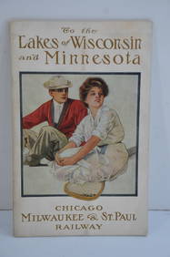
Chicago Milwaukee and St Paul RY To the Lakes of Wisconsin and Minnesota Book-1909JM Hobby Supply and Railroad Artifact Auctions4.4(127)See Sold PriceFeb 24, 2024
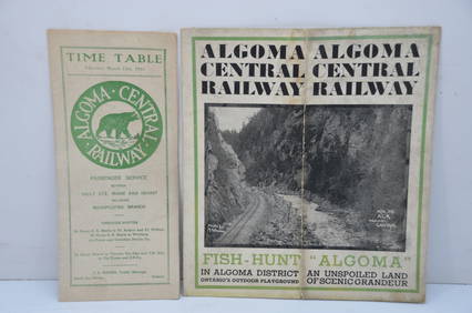
Algoma Central RY March 12, 1944 Public Timetable and BrochureJM Hobby Supply and Railroad Artifact Auctions4.4(127)See Sold PriceFeb 24, 2024
Nova Totius Full Color Geographical World MapThe Benefit Shop Foundation Inc.4.3(2.9k)See Sold PriceFeb 28, 2024
Early 1990s Chicago Transit Authority Fiberglass Line MapRail & Road Auctions4.6(165)See Sold PriceMar 08, 2024
[MAP]. NICHOLLS, Sutton (1668-1729). An Epitome of Sr. Will...Potter & Potter Auctions4.6(545)See Sold PriceMar 07, 2024
Willem Blaeu, Etc. 17th C. Antiquarian Maps, 2Auctions at Showplace4.6(740)See Sold PriceMar 17, 2024
A quantity of World War II / Two military ephemera to include assorted 1940s newspapers pages toClaydon Auctioneers Ltd4.3(125)See Sold PriceFeb 26, 2024
SAMUEL CHAMBERLAIN (Massachusetts/Iowa, 1895-1975), Two prints of Williamsburg, VirginiaEldred's4.7(419)See Sold PriceMar 07, 2024
Two Hand-Colored 19th Century Maps of New Orleans and Louisiana, Larger- H.- 12 1/2 in., W.- 15 1/2Crescent City Auction Gallery4.3(231)See Sold PriceMar 08, 2024
THE ANTIQUE ILLUSTRATED BOOK "1856 ARCTIC EXPLORATIONS: SECOND GIRNEL EXPEDITION 2" BY E. KANENY Elizabeth 4.2(86)See Sold PriceMar 03, 2024
Hubert Kornelisz (1689 - 1733) - Set of 2 Allegorical Copperplate Engravings, NetherlandsProverde Auctions4.3(3)See Sold PriceFeb 28, 2024
Hubert Kornelisz (1689 - 1733) - Set of 2 Allegorical Copperplate Engravings, NetherlandsProverde Auctions4.3(3)See Sold PriceFeb 28, 2024
Galliae Regionis Nova Descriptio Hand Colored Map of France on Laid Paper, Ca. 16th Century, H 10" WDuMouchelles4.6(830)See Sold PriceMar 15, 2024


![[MAP]. NICHOLLS, Sutton (1668-1729). An Epitome of Sr. Will... (1 of 1)](https://p1.liveauctioneers.com/928/318880/171361281_1_x.jpg?height=282&quality=70&version=1707501302)