VINTAGE 18K WHITE GOLD DIAMOND RINGThomaston Place Auction Galleries4.4(393)See Sold PriceFeb 25, 2024
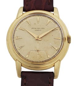
Patek Philippe Calatrava 2525 18k Gold Beveled Vintage Mens Wrist WatchHess Fine Auctions4.5(210)See Sold PriceMar 02, 2024
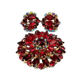
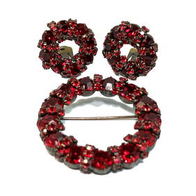
WONDERFIUL VINTAGE JULIANA LOT OF BROOCH AND EARRINGS PRONG SET RHINESTONESNoble House Collection Gallery4.5(123)See Sold PriceFeb 28, 2024
BEAUTIFUL JOSEPH WARNER SET OF SIGNED BROOCH AND EARRINGS PRONG SET RHINESTONESNoble House Collection Gallery4.5(123)See Sold PriceFeb 28, 2024
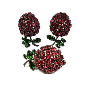
FINE VINTAGE SCHREINER LOT OF BERRY BROOCH AND EARRINGS RHINESTONE PRONG SETNoble House Collection Gallery4.5(123)See Sold PriceFeb 28, 2024
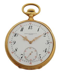
Amazing Patek Philippe 18k Gold Ultra Large 52mm High Grade Pocket Watch Red Chapter NumbersHess Fine Auctions4.5(210)See Sold PriceMar 02, 2024
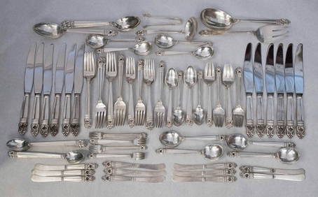
Royal Danish by International Sterling Silver 127 Piece Dinner Flatware Set forMynt Auctions4.6(697)See Sold PriceFeb 24, 2024
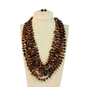
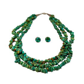
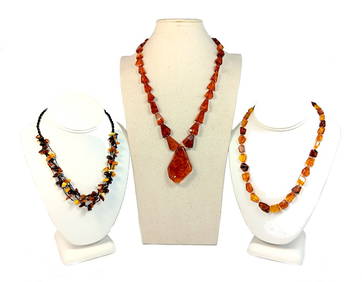
AN EXQUISTE VINTAGE TIGER'S EYE NECKLACE 8 STRAND AND EARRINGS JAY KINGNoble House Collection Gallery4.5(123)See Sold PriceFeb 28, 2024
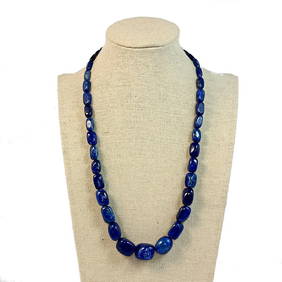
A FABULOUS VINTAGE LAPIS LAZULI NECKLACE BY JAY KING DESERT ROSE 18"Noble House Collection Gallery4.5(123)See Sold PriceFeb 28, 2024
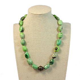
SUPERB VINTAGE NECKLACE NATURAL STONE TURQUOISE STERLING 16"Noble House Collection Gallery4.5(123)See Sold PriceFeb 28, 2024
BEAUTIFUL VINTAGE NATIVE AMERICAN SOUTHWESTERN NECKLACE EARRINGS STERLINGNoble House Collection Gallery4.5(123)See Sold PriceFeb 28, 2024
SoldTwo engravings + map. Map, 18th century, the Grande merTwo engravings + map. Map, 18th century, the Grande mer Indes, Amsterdam di B. Elwe. 18th Century handingkleurde engraving, Amsterdam canal face with Figs. 19th Century sepia, signed C.P.V.B 1871, solSee Sold Price
SoldCaspian Sea Antique Maps (2 parts)Caspian Sea map in two separate parts, north and south:. Carte Marine de la Mer Caspiene. Guillaume Delisle, Paris, 18th Century. Engravings uncolored. Center fold as issued.19 3/4" x 26".See Sold Price
Two Map Engravings.Two Map Engravings. One 18th century hand colored depicting Nubia and Abissinia and the other a 19th century written in French depicting 'Les Cotes D'Ajan et de Zanguebar' Larger sight: 12.5" x 17.5"See Sold Price
SoldTwo 18th C. Maps & Two 18th C. EngravingsLot consists of three 18th century engravings--1st item: Mid 18th century map titled "A New Map of Carolina by Robert Morden"; page taken from a book or publication "A Description of Carolina"; map siSee Sold Price
Sold3 Antique Engraved MapsTwo handcolored engravings; 1 map of "Royaumes D'Aragen et de Navarre avec Catalogne" by M. Bonne. French. 18th Century. Approx 10" H x 14" W w/o frame, 15" H x 19" W framed. Some wear and yellowing.See Sold Price
An 18th century road map engraving, Chester to CardiffAn 18th century road map engraving, Chester to Cardiff, on two sheets, to/w another double-sided road map, Lancaster to Knaresborough, two Thomas Kitchen county maps, Oxfordshire and Suffolk and a VicSee Sold Price
SoldSanson, Sr., (18th Century), Two MapsSanson, Sr. (18th Century) Two Maps hand colored engraving Largest 22 1/2 x 35 inches. Property from the Estate of Marcia B. Nachtrieb.See Sold Price
SoldGEORGE ROLLOS (18TH CENTURY) TWO MAPS.GEORGE ROLLOS (18TH CENTURY) TWO MAPS. Comprised of "An Accurate Map of Turkey in Asia" and "An Accurate Map of Persia," both engravings. Together with two 18th century French engravings depicting ruiSee Sold Price
SoldFRENCH, 18TH CENTURYTwo hand colored engravings including a map, La Mer Aquitanique, together with Vue de L'hotel de Ville de Paris, framed.See Sold Price
Two old / antique Dutch 17th - 18th century maps, city maps. Once Delft by HendrTwo old / antique Dutch 17th - 18th century maps, city maps. Once Delft by Hendrik van Leth. One time Muyden. Crack. Engravings on paper. Size: 22 - 25 cm. In reasonable / good condition.See Sold Price
SoldTwo framed maps including Johann Mattheus, Hasio,Two framed maps including Johann Mattheus, Hasio, Continental 18th century hand colored engraving map Europa (19 1/2'' x 22'') and a Status Ecclesiae at Magni Ducatus Hetruriae Math Sutter August VindSee Sold Price
THREE ANTIQUE 18TH C FRAMED MAPS: SPAIN, ENGLANDLot of three antique 18th century hand colored map engravings. Includes Balearic Islands, Spain, 1778, Antonio Zatta; Buckinghamshire, 1787, J. Cary; and Oxfordshire, 1787, J. Cary. The two smaller EnSee Sold Price
18th C. Map & Two 18th C. EngravingsLot consists of three 18th century engravings--1st item: c. 1765 map of South America, pictorial cartouche lower left "A NEW & CORRECT MAP OF SOUTH AMERICA from the latest Improvements and regulated bSee Sold Price
SoldTwo historical maps of the 18th centTwo historical maps of the 18th century, map of Europe ''Europa secundum legitima'', partly col. copper engraving by Homann Erben about 1740, stained, backed and with missing parts at lower margin, anSee Sold Price
Two 17th - 18th century city maps. Monnekedam, Gorchum.Two 17th - 18th century city maps. Monnekedam, Gorchum. Engravings on paper. Size: 21 x H, B 27 cm / H B 23 x 27 cm. In good condition.See Sold Price
Pair of 18th Century Architecture EngravingTwo engravings from John Soane's "Sketches in Architecture", published by I. & J. Taylor, London, 1793. One titled "Plate XI" and one survey map titled "No. 4. Plan for 30 Acres." Sight size measuresSee Sold Price
SoldTwo 18th century historicTwo 18th century historical maps of France and England, ''Regnorum Magnae Britanniae sive Angliae Scotiae ...'', Bordercol. Copper engraving with figurative cartouche Detail map of the Orkney Islands,See Sold Price
SoldTWO EARLY EUROPEAN MAPS. Map of France by Johann BTWO EARLY EUROPEAN MAPS. Map of France by Johann Baptist Homann (Nuremburg, Germany, 1663-1724), engraving on laid paper with handcoloring, 18th Century, 23"h. 25 1/2"w. (framed); and a map of DenmarkSee Sold Price
SoldTwo 18th century London maps. Thomas Kitchin, A Map ofTwo 18th century London maps. Thomas Kitchin, A Map of the Countries Thirty Miles Round London, engraving c.1773 with outline colour for Noorthouck's History of London, 53 x 55cm; Carrington Bowles, BSee Sold Price
SoldTWO EARLY MAPS. Map of Africa by Johann Matthias HTWO EARLY MAPS. Map of Africa by Johann Matthias Hase (German, 1684-1742), engraving on laid paper with handcoloring, 18th Century, 24"h. 27"w. (framed); and a map of Greece and Crete by Guillaume DelSee Sold Price
18th C Lot of Russia Maps Morden De FerThree engravings including one entitle Moscovie or Russie attributed to Robert Mordern early 18th century, "Grande Tartarie", by N De Fer, , and handcolored plan of the fortress of Tobolsk. All smalleSee Sold Price
18th C Three Russia Maps HandcoloredThree engravings including one entitle Moscovie or Russie attributed to Robert Mordern early 18th century, "Grande Tartarie", by N De Fer, , and handcolored plan of the fortress of Tobolsk. All smalleSee Sold Price
EARLY 18TH C. DUTCH CHART OF PACIFIC OCEAN BY FREDERIK DE WIT (1629-1706) WITH CALIFORNIA AS ANThomaston Place Auction Galleries4.4(393)See Sold PriceFeb 24, 2024
18TH C. ANTIQUE MAP: FRENCH & INDIAN WAR, FRAMEDThomaston Place Auction Galleries4.4(393)See Sold PriceFeb 24, 2024
TWO DUTCH MARINE ENGRAVINGS Late 18th/Early 19th Century 11.5" x 14.5" sight. Framed 17.25" xEldred's4.7(419)See Sold PriceFeb 27, 2024
An early Dutch hand colored engraving map by Georg Balthasar Probst (1732-1801)Ostantix Auctions4.4(11)See Sold PriceFeb 27, 2024
18th Century Hess Germany Hand colored Engraved MapGlobal Auctions Company4.3(36)See Sold PriceMar 03, 2024
Willem Blaeu, Etc. 17th C. Antiquarian Maps, 2Auctions at Showplace4.6(740)See Sold PriceMar 17, 2024
After C. Josse, Early 20th century, Wood engraving, A Portrait of Adolf von Menzel. Together withClaydon Auctioneers Ltd4.3(125)See Sold PriceFeb 26, 2024
1758 MAP PARTIE DE LA MER GLACIALE contenants La Nouvelle Zemble RUSSIA antiqueJasper524.5(9.9k)See Sold PriceFeb 27, 2024
États du Roi de Maroc… d’Alger, Tunis & Tripoli. North Africa. BONNE 1790 mapJasper524.5(9.9k)See Sold PriceFeb 28, 2024
Le Canal de Mosambique, l'Isle de Madagascar… Mozambique. Africa. BONNE 1788 mapJasper524.5(9.9k)See Sold PriceFeb 28, 2024
Le Royaume d’Adel… Ajan & Zanguebar. Adal Ajuran. Kenya Tanzania. BONNE 1788 mapJasper524.5(9.9k)See Sold PriceFeb 28, 2024
Partie Occidentale de l’Afrique. West Africa coast Canary islands BONNE 1788 mapJasper524.5(9.9k)See Sold PriceFeb 28, 2024
Le Royaume d’Adel… Ajan & Zanguebar. Adal Ajuran. Kenya Tanzania. BONNE 1790 mapJasper524.5(9.9k)See Sold PriceFeb 28, 2024
États du Roi de Maroc… d’Alger, Tunis & Tripoli. North Africa. BONNE 1788 mapJasper524.5(9.9k)See Sold PriceFeb 28, 2024
Egypte, Nubie et Abissinie. Egypt, Nubia & Abyssinia. Sudan. BONNE 1788 mapJasper524.5(9.9k)See Sold PriceFeb 28, 2024
Two Hand-Colored 19th Century Maps of New Orleans and Louisiana, Larger- H.- 12 1/2 in., W.- 15 1/2Crescent City Auction Gallery4.3(231)See Sold PriceMar 08, 2024
Late 18th century map of England and Wales sampler and two printsFellows4.3(159)See Sold PriceMar 05, 2024
THE WHOLE CHRONICLE OF POLYBIUS ANCIENT IN ENGLISH, 1756NY Elizabeth 4.2(86)See Sold PriceMar 03, 2024