SoldAN EARLY 20TH CENTURY AFRICAN ASSORTED ITEMSA vintage leather toy Camel with Bedouin. Copper tray with a map of Africa, a lighter with bottle opener and two leather bonding for documents. Dimensions: Smallest: 6 in.Largest: 9 1 /2 in.See Sold Price
SoldTwo Early Maps of Poland,Matthaus Quad, Printed in Cologne, c.1592, detailed map of Southern Poland and the from the Weysel River in the north to the Carpathian Mountains in the south, centered on Auschwitz,Nicholas de Fer, PSee Sold Price
SoldTwo early maps of the United States including Northern Two early maps of the United States including Northern Provinces & Southern Provinces - Drawn and engraved for Thomsons New General Atlas 1817. No. 56 & 57.See Sold Price
SoldLot of Two Early Maps.Includes 17th century Hand Colored Mariette Map of India and Indes Orientales 18" x 24" with huge margins and a Map of Arabia Deserta. 13 1/2" x 16" Black and White.See Sold Price
SoldTwo Early Maps of Poland,Printed in Cologne, c.1592, detailed map of Southern Poland and the from the Weysel River in the north to the Carpathian Mountains in the south, centered on Auschwitz, Nicholas de Fer, Paris 1705, BirSee Sold Price
SoldTwo early mapsNew South Wales & Norfolk Island (Gridley) and Tasmania or Van Dieman’s Land (2) Both simply mounted.See Sold Price
SoldTwo Early Map and Geography Books1909 copy of Baedeker's United States, with 33 old colored maps and 48 plans, as well as a copy of Warren's Brief Course in Geography published by Cowperthwait & Co Philadelphia; Baedeker's book retaiSee Sold Price
SoldTwo Early Maps"J. Churchill Dacuerrean Artist Delhi" (one) states "1856 Delaware Co. Map of New York from actual Survey by Jay Gould Published by Collins G. Keeney No 17 & 19 Minor St. Philadelphia." Paper on canvaSee Sold Price
SoldTwo early maps, GA & US and obsolete currencyLot of two early maps, Georgia and United States along with obsolete currency. 1st item - Early map of Georgia titled, "North America. Sheet XII, Georgia, with Parts of North and South Carolina, TenneSee Sold Price
Sold(EUROPA REGINA.) Two early maps depicting the European(EUROPA REGINA.) Two early maps depicting the European continent as a Queenly personification. Vp, vd Münster, Sebastian. [Europa Regina.] Woodcut, 13½x8¾ inches sheet size, German textSee Sold Price
Two Early Maps of City of JerusalemHistoric MapsTwo Early Maps of Jerusalem, Choice Very Fine. "A Plan of the City of Jerusalem according to the Description thereof in the Books of the Old Testament but more especially in that of NSee Sold Price
SoldTwo Early Maps, One Each By Blaeu and HomannTwo Early Maps, One Each By Blaeu and Homann both hand-colored engravings, the first "Dioecese de Rheims, et le pais de Rethel" by Willem and Joan Blaeu, Amsterdam, circa 1650, depicts Rheims and surrSee Sold Price
SoldTwo Early Maps 1662, 1754Two Early Maps, Map of Asia, c.1662, Family of Willem Janszoon Blaeu, Dutch, ht. 20 1/2, wd. 23 1/4 & Nieuwe Kaart Van het Weftelykste Deel der Weereld, 1734 by IS. Tirion, ht. 15 3/4, wd. 18 1/2See Sold Price
SoldTWO EARLY MAPS. Map of Africa by Johann Matthias HTWO EARLY MAPS. Map of Africa by Johann Matthias Hase (German, 1684-1742), engraving on laid paper with handcoloring, 18th Century, 24"h. 27"w. (framed); and a map of Greece and Crete by Guillaume DelSee Sold Price
SoldTwo early maps- largest of Kent circa 1660, site-Two early maps- largest of Kent circa 1660, site- 17"x21.25", and a map of southern Scotland pub. By Alex R. Hogg, site- 9.5"x13"See Sold Price
SoldTwo Early Maps of JerusalemHistoric MapsTwo Early Maps of Jerusalem, Choice Very Fine. "A Plan of the City of Jerusalem according to the Description thereof in the Books of the Old Testament but more especially in that of NSee Sold Price
SoldTWO EARLY MAPS. Includes "An Accurate Map of SoutTWO EARLY MAPS. Includes "An Accurate Map of South America", Emanuel Bowen, 18th century, engraving on laid paper, handcolored, matted and framed, 15"h. 16 1/4"w.; and a map of the military districtsSee Sold Price
SoldTwo Early Maps of JerusalemJudaicaTwo Early Maps of Jerusalem, Choice Very Fine. "A Plan of the City of Jerusalem according to the Description thereof in the Books of the Old Testament but more especially in that of NehemiaSee Sold Price
SoldTwo Early Maps - CAc1860 This is a pair of framed and matted maps, one of the western United States dated 1860 and the other, a full map of the United Staes, dated 1865. Both are in good condition, with the western mapSee Sold Price
SoldTwo Early Maps of JerusalemJudaicaTwo Early Maps of Jerusalem, Choice Very Fine. “A Plan of the City of Jerusalem according to the Description thereof in the Books of the Old Testament but more especially in that of NehemSee Sold Price
SoldTwo Early Maps of Hollandcomprising "La Reppublica D'ollandia" by Antonio Zatta, Venice, 1776 and "Typis Frisiae Veteris, etc." Map of Friesland by Franciscus Halms, 1718. Both with light creases. Framed, not examined out ofSee Sold Price
SoldTwo Early Maps of JerusalemJudaicaTwo Early Maps of Jerusalem, Choice Very Fine. “A Plan of the City of Jerusalem according to the Description thereof in the Books of the Old Testament but more especially in that of NehemSee Sold Price
SoldGrp: 2 Early Maps of New England de Vaugondy HomaGroup of two early maps of New England or the eastern seaboard of what is now the United States. Includes Robert de Vaugondy (1688–1766), "Partie de L'Amerique Septentrionale, qui comprend le CSee Sold Price
EARLY 18TH C. DUTCH CHART OF PACIFIC OCEAN BY FREDERIK DE WIT (1629-1706) WITH CALIFORNIA AS ANThomaston Place Auction Galleries4.4(394)See Sold PriceFeb 24, 2024
EARLY 18TH C. MAP OF ITALY, FRAMEDThomaston Place Auction Galleries4.4(394)See Sold PriceFeb 24, 2024
Joseph Martin Kronheim Pair Early Color Glamor Prints c1850Luis Porretta Fine Arts4.3(10)See Sold PriceMar 02, 2024
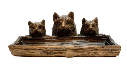
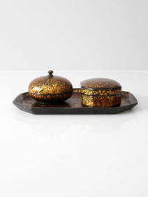
Hand Carved Wood Terrier Dog Pen Tray Ink Well Ink Stand Early 20th CTaylor & Harris4.7(163)See Sold PriceMar 10, 2024
Early 1990s Chicago Transit Authority Fiberglass Line MapRail & Road Auctions4.6(165)See Sold PriceMar 08, 2024
Six Tiffany & Co. Silver Plate Shell Decorated Trays / PlatesHoch LTD.4.6(80)See Sold PriceFeb 25, 2024
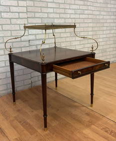
Antique Weiman Heirloom French Louis Style Brass Mounted Tray Top Single Drawer Dessert TableJasper524.5(9.9k)See Sold PriceFeb 28, 2024
NATIVE AMERICAN BASKETRY TWO-HANDLED TRAY Early to Mid-20th Century Diameter 19".Eldred's4.7(423)See Sold PriceMar 07, 2024
Tiffany Studios, New York, Graduate Pattern Gilt Bronze Desk Set of 10 PiecesCoral Gables Auction4.4(523)See Sold PriceFeb 28, 2024
THE ANTIQUE ILLUSTRATED BOOK "1856 ARCTIC EXPLORATIONS: SECOND GIRNEL EXPEDITION 2" BY E. KANENY Elizabeth 4.1(88)See Sold PriceMar 03, 2024
ANTIQUE AMERICAN EMBOSSED SILVER PLATED SERVING TRAYAntique Arena Inc.4.5(883)See Sold PriceMar 09, 2024
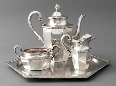
PERSIAN ISFAHAN .84 SILVER TRAY WITH HANDLES, EARLY 20TH CENTURYLos Angeles Antiques 4.3(12)See Sold PriceMar 10, 2024
EIGHT PIECES OF 18th C SHEFFIELD PLATEA.H. Wilkens Auctions & Appraisals4.7(400)See Sold PriceFeb 28, 2024