ATLAS of ANTIENT GEOGRAPHY by SAMUEL BUTLER 1843John McInnis Auctioneers,LLC4.5(505)See Sold PriceFeb 24, 2024
18TH C. ANTIQUE MAP: FRENCH & INDIAN WAR, FRAMEDThomaston Place Auction Galleries4.4(393)See Sold PriceFeb 24, 2024
Rand McNally Railroad Map Cabinet w/ 21 Railroad MapsRail & Road Auctions4.6(165)See Sold PriceMar 08, 2024
Keith Haring - Ink on New York Map, Best Buddies, Inscribed, Signed, and DatedSapphire Auction Gallery4.1(67)See Sold PriceMar 02, 2024
LATE 17TH C. FRENCH MAP OF THE NEW WORLD BY ALEXIS-HUBERT JAILLOT (1632-1712)Thomaston Place Auction Galleries4.4(393)See Sold PriceFeb 24, 2024
Central Railroad of New Jersey Map of Sandy Hook Route-ca. 1903JM Hobby Supply and Railroad Artifact Auctions4.4(127)See Sold PriceFeb 24, 2024
Lot of Six Mixed Atlas Box Cars-HO Scale-New in BoxJM Hobby Supply and Railroad Artifact Auctions4.4(127)See Sold PriceFeb 25, 2024
Rand McNally/Santa Fe Railroad Map of Iowa-1912JM Hobby Supply and Railroad Artifact Auctions4.4(127)See Sold PriceFeb 24, 2024
NICOLAES VISSCHER (NETHERLANDS, 1618-1709) MAP OF THE NEW WORLDThomaston Place Auction Galleries4.4(393)See Sold PriceFeb 24, 2024
17TH C. WORLD MAP BY NICOLAES VISSCHER (NETHERLANDS, 1618-1709)Thomaston Place Auction Galleries4.4(393)See Sold PriceFeb 24, 2024
Lot of Six Mixed Atlas Cabooses-HO Scale-New in BoxJM Hobby Supply and Railroad Artifact Auctions4.4(127)See Sold PriceFeb 25, 2024
SoldTwo 20thC Copies of Old MapsTwo 20thC Copies of Old Maps, A) Early Caribbean map after Christopher Columbus trip, 20 1/2" wide x 15 3/4". B) Early double globe of the world C1617. Estimate: $100 - $200See Sold Price
SoldTwo Early Map and Geography Books1909 copy of Baedeker's United States, with 33 old colored maps and 48 plans, as well as a copy of Warren's Brief Course in Geography published by Cowperthwait & Co Philadelphia; Baedeker's book retaiSee Sold Price
SoldAmshewitz (John Henry) - European Revue. Kill Thatseparately published First World War serio-comic map of Europe, colour-printed wood-engraved map, 390 x 710mm., two repaired splits on old folds, otherwise a clean copy, folding into publisher's printSee Sold Price
SoldAmshewitz (John Henry) - European Revue. Kill Thatseparately published First World War serio-comic map of Europe, colour-printed wood-engraved map, 390 x 710mm., two short splits at ends old folds, otherwise a clean copy, folding into publisher's priSee Sold Price
SoldColton (G.W. & C.B.) - New Map of the City of Brooklynengraved map with extensive original hand-colouring, on tissue-thin paper, 620 x 775mm., old folds with one or two minor splits, a printer's crease lower left, otherwise a crisp clean copy, folding inSee Sold Price
SoldTwo old Maps: ILES BRITANNIQUES & AMERIQUE, approx. 13Two old Maps: ILES BRITANNIQUES & AMERIQUE, approx. 13" X 17" eachSee Sold Price
Two old maps of Middle Eastern areas one marked No. 18Two old maps of Middle Eastern areas one marked No. 18 and titled "Pars Orientalis Inferior", the other marked No. 3 titled "Pars Occidentalis Superior" - both pub. in Paris - 18th century or earlier.See Sold Price
SoldBooks- Lyle Saxon, "Fabulous New Orleans," 1954, twBooks- Lyle Saxon, "Fabulous New Orleans," 1954, two copies, "Old Louisiana," 1950, and "Lafitte The Pirate," 1950, all illustrated by E. H. Suydam.See Sold Price
SoldTwo Old Hand-Drawn Maps: Italy and MissouriTwo Old hand-drawn and hand-painted maps: Italy and Missouri. Size: 8.5" x 8.75", 22 x 23 cm (largest). Provenance: Estate of Robert Swan Lindsley and Eric Hoage, Philadelphia.See Sold Price
SoldTwo Old English Road MapsTwo Old English Road Maps by John Ogilby, published London, 1675-1698, the first "The Roads from London, to Wells in Norfolk and St. Edmons Bury in Suffolk..."; pl. 13" x 17-5/8"; the second "The RoadSee Sold Price
SoldTWO OLD VINTAGE MINING MAPSTWO OLD VINTAGE MINING MAPS. 1931 MAP OF THE MAYFLOWER MINES NEVADA CITY MINING DISTRICT. THIS MAP IS ON LINEN PAPER. WRITING AND DRAWING EXISTS ON ONE MAP. 1936 MAP OF THE SOUTHEASTERLY GRASS VALEY-NSee Sold Price
SoldTwo Hand-Colored Old World MapsTwo Hand-Colored Old World Maps of England/Wales and the Americas, consisting of "Accuratissima Angliae Regni et Walliae Principatus...", engraved by Cornelis Danckerts, ca. 1690-1700, plate 20-1/2" xSee Sold Price
Soldtwo old VT schoolhouse mapsRand McNally wall map of the Eastern & Western Hemispheres in wooden box roller from an old schoolhouse in St George, VT, length 85" sold with another rough wall mapSee Sold Price
SoldFour E.T. Hurley Books of EtchingsTitles include two copies of For Old Acquaintance, 1917 printed by The A.B. Closson Jr. Co., Cincinnati & U.P. James Bookseller, Cincinnati, both 12mo (5 1/4 x 7 3/4") in illustrated paper boards; pluSee Sold Price
SoldLarge Lot of Southwestern Style BellsLarge Lot of Southwestern Style Bells, A large lot (24) of 20thC copies of the old 18th/19thC mission bells, some were hand rung, others rung from the side of a building or freestanding, most are bronSee Sold Price
SoldNEVADA CITY GOLD MINING MAPSTWO OLD GOLD MINING MAPS. 1948THE GRACIE MINE - NEVADA CITY CALIF - PAPER AND LINEN, OLD MAP DEPICTING WHERE CERTAIN GROUPS WERE DIGGING. MONARCH GROUP, BULLION GROUP, PHOENIX GROUP, BUTCHER RANCH GROSee Sold Price
Dickens letter to School for Indigent BlindCharles Dickens (1812-1870) Autograph Letter with holograph envelope. One Page December 20th 1869. Third person letter to the school for the indigent blind. Sending two copies of the old curiosity shoSee Sold Price
SoldSixteen Reference Books on SilverSixteen Reference Books on Silver, including Seymour B. Wyler, The Book of Old Silver (two copies), Howard Okie, Old Silver and Old Sheffield Plate, Judith Bannister, English Silver, N. M. Penzer, PauSee Sold Price
SoldMap of Jerusalem - Two Hand Colored Etchings, Late 16thTwo copies of a map of Jerusalem - Iervsalem, et Suburbia Eius [Jerusalem and its suburbs] by Christian Van Adrichom, hand colored etching and engraving (differences in coloring between the maps). ColSee Sold Price
FOUR MAPS One reproduction from 1906 anFOUR MAPS One reproduction from 1906 and three older maps from 16th and 17th Century, one designed by Christopher Saxton. Estimate $300-500 CONDITION Good to fair, two of the old maps are in good condSee Sold Price
SoldGroup Lot of Four Vintage MapsGrouping of four maps. Including one titled "Wyckoff Franklin Township," two copies titled "Sports' Map of Milford, PA and Vicinity" dated 1934, and one titled "Early Days of Wyckoff," dated 1971 andSee Sold Price
Three Big Old Taureg Brass African Niger Anklet Bracelet Currency CuffsArarity Auctions4.6(177)See Sold PriceMar 03, 2024
Two Old and Heavy African Copper Burkina Faso Tribal Currency BraceletsArarity Auctions4.6(177)See Sold PriceMar 03, 2024
[SHEET MUSIC]. [MINSTRELSY]. Group of 33 Sheet Music Depict...Potter & Potter Auctions4.6(545)See Sold PriceMar 07, 2024
Mckenney & Hall - Two Octavo Volumes of Text with Rare Plate of Billy BowlegsTrillium Antique Prints & Rare Books4.5(32)See Sold PriceFeb 24, 2024
Handkerchief.- Census (The), 3 April 1881, satirical printed cotton handkerchief, 1881 & others,Forum Auctions4.3(53)See Sold PriceFeb 29, 2024
Morocco, Algeria, Tunisia & Libya. North Africa. HUGHES 1876 old antique mapJasper524.5(9.9k)See Sold PriceFeb 28, 2024
West Africa by Arrowsmith & Lewis 1812 old antique vintage map plan chartJasper524.5(9.9k)See Sold PriceFeb 28, 2024
CAP VERT. French/Portuguese Guinea Gambia Senegal Sierra Leone 1947 old mapJasper524.5(9.9k)See Sold PriceFeb 28, 2024
Western Sahara. Africa 1885 old antique vintage map plan chartJasper524.5(9.9k)See Sold PriceFeb 28, 2024
NORTH AFRICA.Afrika;Atlaslander Morocco Algeria Marokko Algerien 1958 old mapJasper524.5(9.9k)See Sold PriceFeb 28, 2024
Eastern Sahara. Africa. Libya Niger Algeria Chad Nigeria 1885 old antique mapJasper524.5(9.9k)See Sold PriceFeb 28, 2024
AFRICA. Political Map of showing International Boundaries 1936 old vintageJasper524.5(9.9k)See Sold PriceFeb 28, 2024
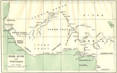
AFRICA. Niger River and Tributaries 1936 old vintage map plan chartJasper524.5(9.9k)See Sold PriceFeb 28, 2024
NAMIBIA. South West Africa protectorate. HARMSWORTH 1920 old antique map chartJasper524.5(9.9k)See Sold PriceFeb 28, 2024
Africa by Arrowsmith & Lewis 1812 old antique vintage map plan chartJasper524.5(9.9k)See Sold PriceFeb 28, 2024
1675: ANTIQUE ILLUSTRATED JULIUS CAESAR MAPS OF ROMAN HISTORYNY Elizabeth 4.2(86)See Sold PriceMar 03, 2024


![[SHEET MUSIC]. [MINSTRELSY]. Group of 33 Sheet Music Depict... (1 of 6)](https://p1.liveauctioneers.com/928/318880/171361182_1_x.jpg?height=282&quality=70&version=1707501302)