SoldTwo 18th Century French Maps of Eastern SeaboardTwo 18th Century French Maps of Eastern Seaboard both hand-colored engravings by J. Bellin, Paris, 1757; the first map "Carte De La Nouvelle Angleterre, Nouvelle Yorck et Pensilvanie," shows much of tSee Sold Price
Sold18th century French Map of the Eastern Seaboard18th century French Map of the Eastern SeaboardPARTIE DE L'AMERIQUE SPTENTRIONALE, QUI COMPREND LE COURS DE L'OHIO, LA NUE ANGLOTERRE, LA NUE YORK, LE NEW JERSEY, LA PENSYLVANIE, LE MARYLAND, LA VIRGISee Sold Price
SoldTwo 18th Century French World MapsA nautical world map, signed at the lower right corner "Moithey Ing.Geo. del et sculp Herault Scrip" and a world map published by Delmarche. Both hand colored. Dimensions: Each frame is 13" x 18 1/2".See Sold Price
SoldTwo 18th Century French Made European MapsTwo 18th century French made map prints, framed. "Carte Des Isles Britanniques" 23" x 30" map of the British Islands made in Paris by C.F. Delamarche, and 23" x 28 1/2" 1702 French West Coast map. SomSee Sold Price
SoldTwo 18th Century French Caribbean Island Mapscirca 1760, copperplate engravings with outline color depicting Barbados and Grenada. Presented in wooden frames. DOA 13 x 10.75 in. From the Collection of Colette Gaudron, Southeast Asia & Chapel HilSee Sold Price
SoldFramed colored map of North America,Framed colored 17th/18th century map of North America, detailed map showing eastern seaboard extending to the Caribbean, the western U.S being largely uncharted with Mendocino Bay being the last northSee Sold Price
SoldGEORGE ROLLOS (18TH CENTURY) TWO MAPS.GEORGE ROLLOS (18TH CENTURY) TWO MAPS. Comprised of "An Accurate Map of Turkey in Asia" and "An Accurate Map of Persia," both engravings. Together with two 18th century French engravings depicting ruiSee Sold Price
18th century French map of U.S.,"Carte des Etats-Unis…M. Brion de la Tour…Paris," undated, probably mid-18th century, eastern coast of United States from Florida to New England, hand-colored features, damage and losses to upperSee Sold Price
Sold18th Century Map of VirginiaThe State of Virginia, from the best Authorities, by Samuel Lewis, 1794, probably from Carey's American edition of [Guthrie's Geography Improved,] from the eastern seaboard to the Appalachian mountainSee Sold Price
SoldGroup of French Maps Guillaume de l'Isle SansonGroup of four 17th and 18th century French maps. Guillaume Delisle (1675-1726) hand colored engraved map of Picardie, 1748. Two maps by Nicolas Sanson (1600-1677), "Le Roayaume de France" and "GouvernSee Sold Price
SoldTWO 18TH CENTURY OCEANICA MAPS.TWO 18TH CENTURY OCEANICA MAPS. One of the Mare Nigrum and the other of the Mare Mediterranaeum. Both written in Latin. Together with three assorted Oceanica maps, one French harbor map, and three marSee Sold Price
18th century map of eastern UnitedStates, "The Marches of Lord Cornwallis in the Southern Provinces, now States of North America; Comprehending the Two Carolinas, with Virginia and Maryland, and the Delaware Counties. By William FadenSee Sold Price
SoldTwo French Maps of the Americas18th century: "[Carte Du Golphe Du Mexique et des Isles De L'Amerique…,]" by M. Bellin, from Prevost d'Exiles' [L'Histoire Generale des Voyages,] Paris, 1754, showing portions of the southeastern UnSee Sold Price
SoldMathieu Bonne (French, fl. circa 1720-1805)Mathieu Bonne (French, fl. circa 1720-1805) hand-colored engraved map of eastern North American, fourth quarter 18th century, 15" x 10-1/2". Presented in a narrow fruitwood frame and glazed.See Sold Price
Sold3 Antique Engraved MapsTwo handcolored engravings; 1 map of "Royaumes D'Aragen et de Navarre avec Catalogne" by M. Bonne. French. 18th Century. Approx 10" H x 14" W w/o frame, 15" H x 19" W framed. Some wear and yellowing.See Sold Price
SoldFRENCH, 18TH CENTURYTwo hand colored engravings including a map, La Mer Aquitanique, together with Vue de L'hotel de Ville de Paris, framed.See Sold Price
SoldTwo Overton maps, Italy, Mediterranean(Henry Overton, British, working 1707-1749): one Mediterranean Sea based on map by N. Sanson (French, 1600-1667), undated, early 18th century, 19 x 32-1/2 in. (sight); one of Italy, dedicated to KingSee Sold Price
Two Map Engravings.Two Map Engravings. One 18th century hand colored depicting Nubia and Abissinia and the other a 19th century written in French depicting 'Les Cotes D'Ajan et de Zanguebar' Larger sight: 12.5" x 17.5"See Sold Price
SoldThree Copperplate Maps of Cyprus on Disbound Bookto include two hand-colored 17th century maps, one with Italian text and one with French text, plus an 18th century map without color. The maps presented in silver-toned wooden frames. DOA 17.74 x 14.See Sold Price
A PAIR OF 20 BORE FRENCH FLINTLOCK PISTOLS FOR THEA PAIR OF 20 BORE FRENCH FLINTLOCK PISTOLS FOR THE EASTERN MARKET BY ROYET, MID-18TH CENTURY, PROBABLY ST ETIENNE with tapering gilt-brass barrels formed in two stages, fitted with silver bead fore-siSee Sold Price
Sold(5) French & Belgium TapestriesIncluding a matching set of three depictions of 18th century high society, and two depictions of middle eastern peoples with horses, donkeys, and camel, the largest is 20" H x 57" W, circa early 20thSee Sold Price
SoldSet of three copper engraved maps(lot of 3) Copper engraved 18th century maps with hand coloring, depicting Italy, Switzerland, Sweden, and Norway and all with later French text, two dated 1766, all by St. BrionSee Sold Price
SoldJEAN JANVIER "ATLAS MODERNE LE SIEUR" 18th CENTURYJANVIER "ATLAS MODERNE LE SIEUR "18TH CENTURY Jean (Robert) Janvier ( French 1746-1776 ) Cartographer Le Sieur, plate # 18 in Jean Janvier 1776 Atlas Moderne Map of Eastern Europe 1771 "DE Hongrie" DiSee Sold Price
SoldSet of three copper engraved maps(lot of 3) Copper engraved 18th century maps with hand coloring, depicting Italy, Switzerland, Sweden, and Norway and all with later French text, two dated 1766, all by St. BrionSee Sold Price
18TH C. ANTIQUE MAP: FRENCH & INDIAN WAR, FRAMEDThomaston Place Auction Galleries4.4(393)See Sold PriceFeb 24, 2024
Willem Blaeu, Etc. 17th C. Antiquarian Maps, 2Auctions at Showplace4.6(740)See Sold PriceMar 17, 2024
1758 MAP PARTIE DE LA MER GLACIALE contenants La Nouvelle Zemble RUSSIA antiqueJasper524.5(9.9k)See Sold PriceFeb 27, 2024
1749 MAP CARTE DE LA TARTARIE ORIENTALE RUSSIA & CHINA antique EASTERN TARTARYJasper524.5(9.9k)See Sold PriceFeb 27, 2024
Late 18th century map of England and Wales sampler and two printsFellows4.3(159)See Sold PriceMar 05, 2024
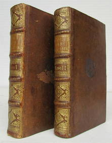
1731 TWO VOLUMES ADVANCED SCIENCE IN FRENCH BY BERNARD FONTENELLENY Elizabeth 4.2(86)See Sold PriceMar 03, 2024
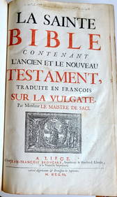
1702 FRENCH BIBLE LA SAINTE BIBLE VINTAGE OLD & NEW TESTAMENT FOLIONY Elizabeth 4.2(86)See Sold PriceMar 03, 2024
NICOLAS LEMERY'S 1717 PHARMACOPEIA IS AN OLD FRENCH PHARMACOLOGY TREATISE FROM THE 17TH CENTURY.NY Elizabeth 4.2(86)See Sold PriceMar 03, 2024
ANTIQUE ILLUSTRATED HANDBOOK OF GEOGRAPHY AND TRAVEL IN ASIA, VOLUME 2, 1896NY Elizabeth 4.2(86)See Sold PriceMar 03, 2024
1783 ANTIQUE CHINESE MORALS OF CONFUCIUS PHILOSOPHER FRENCH PHILOSOPHY OF CHINANY Elizabeth 4.2(86)See Sold PriceMar 03, 2024
1774: AN ANTIQUE ILLUSTRATED TWO-VOLUME HISTORY OF PERUVIAN DISCOVERY AND CONQUEST WITH MAPNY Elizabeth 4.2(86)See Sold PriceMar 03, 2024
THE WHOLE CHRONICLE OF POLYBIUS ANCIENT IN ENGLISH, 1756NY Elizabeth 4.2(86)See Sold PriceMar 03, 2024
1792 OLD INDIA HISTORY ANTIQUE ILLUSTRATED WITH MAPS OF THE EIGHTEENTH CENTURY IN FRENCHNY Elizabeth 4.2(86)See Sold PriceMar 03, 2024
1754 THEOPHRASTE'S 2 VOLUME ANTIQUE GREEK-TO-FRENCH VELLUM CHARACTERSNY Elizabeth 4.2(86)See Sold PriceMar 03, 2024
FRENCH CUPIDS OIL PAINTING AFTER FRANCOIS BOUCHERAntique Arena Inc.4.5(878)See Sold PriceMar 09, 2024