ATLAS of ANTIENT GEOGRAPHY by SAMUEL BUTLER 1843John McInnis Auctioneers,LLC4.6(502)See Sold PriceFeb 24, 2024
18TH C. ANTIQUE MAP: FRENCH & INDIAN WAR, FRAMEDThomaston Place Auction Galleries4.4(386)See Sold PriceFeb 24, 2024
Rand McNally Railroad Map Cabinet w/ 21 Railroad MapsRail & Road Auctions4.6(165)See Sold PriceMar 08, 2024
Keith Haring - Ink on New York Map, Best Buddies, Inscribed, Signed, and DatedSapphire Auction Gallery4(67)See Sold PriceMar 02, 2024
LATE 17TH C. FRENCH MAP OF THE NEW WORLD BY ALEXIS-HUBERT JAILLOT (1632-1712)Thomaston Place Auction Galleries4.4(386)See Sold PriceFeb 24, 2024
Central Railroad of New Jersey Map of Sandy Hook Route-ca. 1903JM Hobby Supply and Railroad Artifact Auctions4.4(126)See Sold PriceFeb 24, 2024
Lot of Six Mixed Atlas Box Cars-HO Scale-New in BoxJM Hobby Supply and Railroad Artifact Auctions4.4(126)See Sold PriceFeb 25, 2024
Rand McNally/Santa Fe Railroad Map of Iowa-1912JM Hobby Supply and Railroad Artifact Auctions4.4(126)See Sold PriceFeb 24, 2024
NICOLAES VISSCHER (NETHERLANDS, 1618-1709) MAP OF THE NEW WORLDThomaston Place Auction Galleries4.4(386)See Sold PriceFeb 24, 2024
17TH C. WORLD MAP BY NICOLAES VISSCHER (NETHERLANDS, 1618-1709)Thomaston Place Auction Galleries4.4(386)See Sold PriceFeb 24, 2024
Lot of Six Mixed Atlas Cabooses-HO Scale-New in BoxJM Hobby Supply and Railroad Artifact Auctions4.4(126)See Sold PriceFeb 25, 2024
SoldTravel Poster London Cycling Road Map 50 Miles FoldedOriginal vintage folded map of Bacon's Cycling Road Map - 50 Miles Round London. Publlished by G.W. Bacon & Co. Ltd, 127 Strand, London. George Washington Bacon (1830–1922) was an American mapmSee Sold Price
1915 Bacon Map of SouthEast England for Cyclists and1915 Bacon Map of SouthEast England for Cyclists and Autos -- Bacon's Cycling and Motoring Road Map of South East England Sheet No.6 (of England) … Fifty Miles Around London 1915 c., London G BaconSee Sold Price
Bacon's Motoring & Cycling Road Map (Scale 3 Miles to 1Title: Bacon's Motoring & Cycling Road Map (Scale 3 Miles to 1 Inch) Inverness District. Publication Date: c1925 Cartographer: Bacon, G.W. & Co. Publisher: G.W. Bacon & Co., LTD. Size: 25.25Height - 2See Sold Price
SoldLondon and Brighton.- Edwards (J.) Edwards's GeneralLondon and Brighton.- Edwards (J.) Edwards's General Map of 1400 Square Miles, map of the road from London to Brighton, East Surrey and East Sussex, with north oriented to the left, engraving with hanSee Sold Price
London and Brighton.- Edwards (J.) Edwards's GeneralLondon and Brighton.- Edwards (J.) Edwards's General Map of 1400 Square Miles, map of the road from London to Brighton, East Surrey and East Sussex, with north oriented to the left, engraving with hanSee Sold Price
SoldTravel Poster Brisbane City Suburbs Australia MapOriginal vintage folded map of Brisbane city, Australia and its suburbs, as No. 77 of the series 'Gregory's Road Map', and officially recognised by the Royal Automobile Club of Queensland. Brisbane RiSee Sold Price
SoldTravel Poster ChildrenOriginal vintage folded map of a Children's Map of London, printed and published by John Bartholomew & Son Ltd of Edinburgh. Collins Bartholomew, formerly John Bartholomew and Son, is a long-establishSee Sold Price
Bacon: Antique Cycling Map of SouthEast England, 1915Title/Content of Map: 1915 Bacon Map of SouthEast England for Cyclists and Autos -- Bacon's Cycling and Motoring Road Map of South East England Sheet No.6 (of England) … Fifty Miles Around LondoSee Sold Price
1915 Bacon Map of SouthEast England for Cyclists andTitle/Content of Map: 1915 Bacon Map of SouthEast England for Cyclists and Autos -- Bacon's Cycling and Motoring Road Map of South East England Sheet No.6 (of England) … Fifty Miles Around London DaSee Sold Price
Bacon: Antique Map of SouthEast England for CyclistsTitle/Content of Map: 1915 Bacon Map of SouthEast England for Cyclists and Autos -- Bacon's Cycling and Motoring Road Map of South East England Sheet No.6 (of England) … Fifty Miles Around London DaSee Sold Price
1915 Bacon Map of SouthEast England for Cyclists andTitle/Content of Map: 1915 Bacon Map of SouthEast England for Cyclists and Autos -- Bacon's Cycling and Motoring Road Map of South East England Sheet No.6 (of England) … Fifty Miles Around London DaSee Sold Price
SoldFRAMED "HUB CYCLING MAP OF LONDON DISTRICT"Framed map, "The Hub Cycling Map of London District", "Reduced from the New Ordance Survey", belived to be early 20th.c, the margin with advertising for Dunlop "for cycles and carriages", 1"=2 miles sSee Sold Price
Geographia Large Scale Road Map of London.Title/Content of Map: Geographia Large Scale Road Map of London. Cartographer: "Geographia" Ltd. Date: c1935 Publisher: "Geographia" Ltd. Size: 30.75Height - 39.25Width 30 miles round London arterialSee Sold Price
Geographia Large Scale Road Map of London.Title/Content of Map: 'Geographia Large Scale Road Map of London. Date: 1935 ca. Cartographer: "Geographia" Ltd. Size: 30.75X39.25 30 miles round London arterial and by-pass roads prominently indicateSee Sold Price
'Geographia Large Scale Road Map of London.Title: 'Geographia Large Scale Road Map of London. Cartographer: "Geographia" Ltd. Publisher: "Geographia" Ltd. Height: 30.75 Width: 39.25 30 miles round London arterial and by-pass roads prominentlySee Sold Price
Bacon's Motor Road Map of Scotland c.1930s Cloth BackedBacons Motor Road Map, Scotland Scale 8 Miles = 1 Inch, c.1930s Publisher. G.W. Bacon & Co, Ltd. Price on cover 4s.0d. Blue boards 8x5 inches. Folded colour map 39x29 inches. Cloth (Gauze) Backed. NOTSee Sold Price
Bacons Motor Road Map c.1930s: Scotland. On ClothBacons Motor Road Map, Scotland Scale 8 Miles = 1 Inch, c.1930s Publisher. G.W. Bacon & Co, Ltd. Price on cover 4s.0d. Blue boards 8x5 inches. Folded colour map 39x29 inches. Cloth (Gauze) Backed. NOTSee Sold Price
Bacons Motor Road Map c.1930s: Scotland. On ClothBacons Motor Road Map, Scotland Scale 8 Miles = 1 Inch, c.1930s Publisher. G.W. Bacon & Co, Ltd. Price on cover 4s.0d. Blue boards 8x5 inches. Folded colour map 39x29 inches. Cloth (Gauze) Backed. NOTSee Sold Price
Bacons Motor Road Map c.1930s: Scotland. On ClothBacons Motor Road Map, Scotland Scale 8 Miles = 1 Inch, c.1930s Publisher. G.W. Bacon & Co, Ltd. Price on cover 4s.0d. Blue boards 8x5 inches. Folded colour map 39x29 inches. Cloth (Gauze) Backed. NOTSee Sold Price
Bacons Motor Road Map c.1930s: Scotland. On ClothBacons Motor Road Map, Scotland Scale 8 Miles = 1 Inch, c.1930s Publisher. G.W. Bacon & Co, Ltd. Price on cover 4s.0d. Blue boards 8x5 inches. Folded colour map 39x29 inches. Cloth (Gauze) Backed. NOTSee Sold Price
SoldRoad map to golf links 30 miles round LondonHeading: Author: Gross, Alexander Title: 30 Miles Round London: Golf Links in Area of 30 Miles Round London Place Published: London Publisher:Geographia Ltd. Date Published: 1913 DescrSee Sold Price
SoldBritain.- Cary (John) Cary's Actual Survey of theBritain.- Cary (John) Cary's Actual Survey of the Fifteen Miles Round London, engraved double-page general map and 50 engraved single-page maps, hand-coloured in outline, general map linen-backed withSee Sold Price
Map – Bacon’s New Map of London c.1880s...Map – Bacon’s New Map of London c.1880s, divided into half mile squares and circles, scale 4”to the mile, back with linen and folded in 16 sections, 76x98cm approx., small tears in places alongSee Sold Price
Bacons Motor Road Map: England & Wales, North. c.1920sBacons Motor Road Map. North Sheet. England & Wales. Scale. 8 miles = 1 inch Publisher. G.W. Bacon & Co, Ltd. Price on cover 5/=. Folded colour map 29 x 39. Grey/Blue cloth boards 7.5x4.5x0.5 inches (See Sold Price
17TH C. ENGLISH LINEAR MAP BY OGILBY, FRAMEDThomaston Place Auction Galleries4.4(386)See Sold PriceFeb 24, 2024
Museum of Horrors - King of Pigs -Emil Zola - 1899Levy Auction House4.3(11)See Sold PriceFeb 27, 2024
Three Switzerland and Spain Railway Advertising Travel PostersRail & Road Auctions4.6(165)See Sold PriceMar 07, 2024
Large Assortment of Railroad Items - Insulators, Globes, Hand Bell, Posters, Maps, Timetables,Rail & Road Auctions4.6(165)See Sold PriceMar 07, 2024
1853 Colton's Railroad & Township Map of Massachusetts, Rhode Island, and ConnecticutRail & Road Auctions4.6(165)See Sold PriceMar 07, 2024
1855 Map of New York & Erie Railroad and 1917 Trespassing On Railway Property Is A MisdemeanorRail & Road Auctions4.6(165)See Sold PriceMar 07, 2024
Three Delaware & Hudson Canal Company Railroad Annual Passes - 1884, 1885, and 1886Rail & Road Auctions4.6(165)See Sold PriceMar 08, 2024
1867 Map of the Railroads of The State of New YorkRail & Road Auctions4.6(165)See Sold PriceMar 08, 2024
New York, New Haven & Hartford Railroad "The Kid in Upper 4" World War II Advertising / TravelRail & Road Auctions4.6(165)See Sold PriceMar 08, 2024
1931 Baltimore and Ohio Railroad Travel Poster - "A Shipment of Gold"Rail & Road Auctions4.6(165)See Sold PriceMar 08, 2024
[ARCTIC]. BOWEN, Emanuel. A New & Accurate Map of the North...Potter & Potter Auctions4.6(539)See Sold PriceMar 07, 2024
[POSTCARDS] Twenty-eight Tourist Travel Vintage Postcards. ...Potter & Potter Auctions4.6(539)See Sold PriceMar 07, 2024
[CHICAGO]. Rare Pre-Fire Illinois Map: “Blanchard’s Map of ...Potter & Potter Auctions4.6(539)See Sold PriceMar 07, 2024
[BUSINESS]. Travel Guide of Negro Hotels and Guest Houses. Published by Afro-American Newspapers ofFreeman's | Hindman4.4(1.6k)See Sold PriceFeb 27, 2024
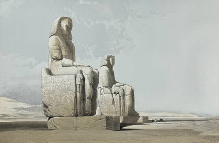
David Roberts - Obelisk of LuxorTrillium Antique Prints & Rare Books4.5(30)See Sold PriceFeb 24, 2024
David Roberts - Approach of the Simoom, Desert of GizehTrillium Antique Prints & Rare Books4.5(30)See Sold PriceFeb 24, 2024
Karl Bodmer - Scalp Dance of the Minatarres. 27Trillium Antique Prints & Rare Books4.5(30)See Sold PriceFeb 24, 2024
Matson SS Mariposa South Seas Lithograph Travel Cruise PosterClark's Auction Company4.6(433)See Sold PriceMar 03, 2024
Churchill & Nieuhof 1744 Folio Map. Batavia Indonesia East IndiesAlbion Auctions4.6(336)See Sold PriceMar 01, 2024


![[ARCTIC]. BOWEN, Emanuel. A New & Accurate Map of the North... (1 of 1)](https://p1.liveauctioneers.com/928/318880/171360917_1_x.jpg?height=282&quality=70&version=1707501302)
![[POSTCARDS] Twenty-eight Tourist Travel Vintage Postcards. ... (1 of 1)](https://p1.liveauctioneers.com/928/318880/171361149_1_x.jpg?height=282&quality=70&version=1707501302)
![[CHICAGO]. Rare Pre-Fire Illinois Map: “Blanchard’s Map of ... (1 of 2)](https://p1.liveauctioneers.com/928/318880/171361260_1_x.jpg?height=282&quality=70&version=1707501302)
![[BUSINESS]. Travel Guide of Negro Hotels and Guest Houses. Published by Afro-American Newspapers of (1 of 4)](https://p1.liveauctioneers.com/197/319238/171467937_1_x.jpg?height=282&quality=70&version=1707520367)