SoldThree Framed Hand-Colored Maps[A New and Accurat Map of the World], by P. Kaerius/John Speed, Amsterdam, circa 1646, miniature version, 3-3/8 x 4-7/8 in. (sight), [toning]; [Tiipus Orbis Terrarum] by Phillipe Galle, circa 1574, thSee Sold Price
SoldSET OF 3 18th CENTURY FRAMED HAND COLORED MAPSSET OF THREE 18th CENTURY FRAMED HAND COLORED MAPS OF BARBADOS, ANTILLES, JAMAICA, CIRCA 1766.See Sold Price
SoldHandcolored engravings Antique MapsThree framed handcolored engravings, Antique Maps (Golphe de Grimaul; Bovin, Forte de St Anne)See Sold Price
SoldThree framed Beers atlas local Dutchess County handThree framed Beers atlas local Dutchess County hand colored maps including Rhinebeck, Rhinecliff, and Red Hook. Published in 1867. Provenance: Private donation to the Northern Dutchess Hospital in RhiSee Sold Price
SoldFOUR FRAMED ETCHINGS FROM JAMES BEVERALL'S 'LE GRANDFOUR FRAMED ETCHINGS FROM JAMES BEVERALL'S 'LE GRAND BRETAGNE & DE L'IRLANDE'. Hand colored. Together with three framed maps comprising one hand colored etching depicting Tartaire (Russia), (printed iSee Sold Price
SoldHand-colored map, Johann Baptiste Homann, 1720Framed hand-colored map, Accurater Prospect und Grundris de Konigl: Gros Britanisch: Haupt und Reidentz Stadt London, Nurnberg, c. 1720, by Johann Baptiste Homann and Family, double-page, with three cSee Sold Price
SoldTHREE ANTIQUE FRAMED MAPSincluding a double page, hand-colored map of Norlingen Germany dated 1549, a double page uncolored engraving of Albany NY dated 1794, and an early hand colored etching of Franconia, Germany, likely c.See Sold Price
SoldThree Framed 18th and 19th Century Maps and a FramedThree Framed 18th and 19th Century Maps and a Framed Historical Engraving, a hand-colored Plan de la Ville et Faubourg De Paris, a Laurie & Whittle hand-colored New Map of Switzerland, a lithograph PlSee Sold Price
SoldFramed Italian Engraved Hand Colored Map of theFramed Italian Engraved Hand Colored Map of the Adriatic Sea, with Latin and Italian writing; focusing on three islands: San Domino, Santo Niccola, and La Caprara; written in Latin at the top "InsulaeSee Sold Price
Sold1671 VIRGINIA AND THE CHESAPEAKE BAY REGION HAND-1671 VIRGINIA AND THE CHESAPEAKE BAY REGION HAND-COLORED MAP, "Nova Virginiae Tabula", John Ogilby and Arnoldus Montanus, three large cartouches, not framed. Second half 17th century. 11 3/4" x 14 1/4See Sold Price
SoldLot of Antique Hand-Colored MapsLot consisting of three 19th century hand-colored maps, including Salisbury, Connecticut (18 1/2" x 21" framed); Redding, Connecticut (19" x 22" framed); and Pound Ridge, New York (20" x 23 1/2" frameSee Sold Price
SoldThree Vintage Framed World & African MapsThree Vintage Framed World & African Maps. One with silver leaf and Latin, one hand colored on parchment type paper, one showing African. Largest measures 23 by 26 inches.See Sold Price
SoldTHREE AMERICAN FRAMED PIECES.Twentieth century. Watercolor of a Shaker village map by “Sister Karlyn Cauley, July 4, 1987”, 13”h. 10.25”w., hand-colored photograph of a woman in gesso molded frame, 17&rdquSee Sold Price
Sold3 ANTIQUE HAND COLORED COPPER ENGRAVED MAPSA collection of three antique hand colored copper engraved maps. Ht: 20.75" Wd: 25.75" (largest, framed)See Sold Price
SoldTHREE 18TH/19TH C. MAPSIncluding Europe and Great Britain; Engravings on paper, two hand colored (framed); Largest: 19 3/4" x 22 1/2"See Sold Price
Sold1830 Chapman & Hall Celestial Atlas pagesthree 1830 Chapman & Hall Celestial Atlas pages, hand colored, framed, sold with two Alexander Hogg Astronomy platesSee Sold Price
SoldFRENCH MAPS [3] V. LEVASSEUR, ATLAS ILLUSTREFRENCH MAPS [3] 12" X 17" V. LEVASSEUR, ATLAS ILLUSTRE: Three maps. Visible paper size: 12" x 17". Framed size: 16" x 22". Hand colored. Region du Nord No 26 and No 28. Also Region du Sud No 14. One mSee Sold Price
FRAMED CONTINENTAL MAPSThree: Jerusalem (after Juan Bautista Villalpando), eight 3" x 5" maps/cityscapes from various European locations from book by Gabriel Bucelin, and a hand colored reprint of Nassovia Comitatus (RhinelSee Sold Price
SoldA Set of Three Framed Hand-Colored Lobster EngravingsA Set of Three Framed Hand-Colored Lobster Engravings AFTER F.D. HEIDENRICH, 20TH CENTURY Comprising plates XXXII, XXVIII, and XXX. Plate dimensions of two 18 1/2 x 11 1/2 inches; plate dimensions ofSee Sold Price
SoldFRAMED HAND-COLORED MAP "Vectis Insula, Anglice: TheFRAMED HAND-COLORED MAP "Vectis Insula, Anglice: The Isle of Wight", showing coats of arms in upper right, c. 1648, published in Amsterdam, framed by "Goodspeed's Book Shop, Boston" label on reverse",See Sold Price
SoldFramed Hand Colored Map of The World 19th CenturyFramed Hand Colored Map of The World 19th Century. Original Map of World Hemispheres with supposed population and religious division. Certificate of Authenticity on back.Condition: Very Good, slight wSee Sold Price
SoldTwo Early Framed Hand Colored Mapscomprising Johann Baptist Homann (German, 1664-1724), "Nova Anglia" and a smaller unsigned map, "Dania Regnum." Not examined out of frames. Stains, toning. Largest: 27 1/2" high, 30 1/2" wide. ProvenaSee Sold Price
SoldAntique Framed & Hand Colored Map of LiverpoolAntique Framed & Hand Colored Map of Liverpool England. Measures 20 x 24 inches.See Sold Price
SoldFramed Hand Colored Map of Wilshire, EnglandFramed Hand Colored Map of Wilshire, England. 29 inches x 32 inchesSee Sold Price
17TH C. ANTIQUE MAP SIEGE OF LA ROCHELLE, FRANCE, FRAMEDThomaston Place Auction Galleries4.4(386)See Sold PriceFeb 24, 2024
EARLY 18TH C. MAP OF ITALY, FRAMEDThomaston Place Auction Galleries4.4(386)See Sold PriceFeb 24, 2024
18TH C. ANTIQUE MAP: FRENCH & INDIAN WAR, FRAMEDThomaston Place Auction Galleries4.4(386)See Sold PriceFeb 24, 2024
17TH C. ENGLISH LINEAR MAP BY OGILBY, FRAMEDThomaston Place Auction Galleries4.4(386)See Sold PriceFeb 24, 2024
WILLEM JANSZOON BLAEU (NETHERLANDS, 1571-1638) MAP OF UMBRIAThomaston Place Auction Galleries4.4(386)See Sold PriceFeb 24, 2024
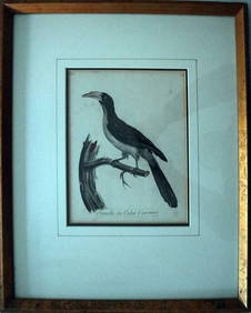
Le Valliant Crowned Hornbill Calao Couronne Rare Engraving ca1802 Framed OrnithologyLuis Porretta Fine Arts4.3(10)See Sold PriceMar 02, 2024
MARTIN VILLALBA Three Baristas Limited Ed 11/50 Engraving Hand ColoredLuis Porretta Fine Arts4.3(10)See Sold PriceMar 02, 2024
VENET / DEBUCOURT (1755-1832) Set 3 x Aquatint Engraved Hunting Scenes 23" x 16"Luis Porretta Fine Arts4.3(10)See Sold PriceMar 02, 2024
WILLIAM HEATH Rare Political Cartoon Siamese Youths c1829 LithographLuis Porretta Fine Arts4.3(10)See Sold PriceMar 02, 2024
THOMAS MOULE 1837 Colored Map of Warwickshire Framed vgcLuis Porretta Fine Arts4.3(10)See Sold PriceMar 02, 2024
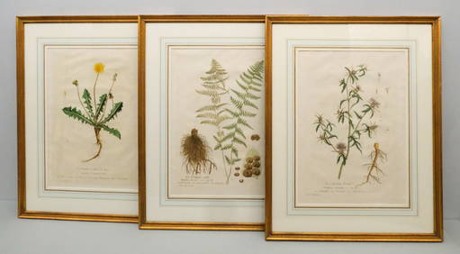
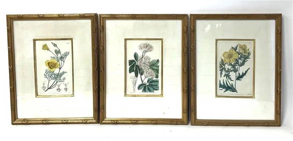
William Curtis; Three(3)19thC. English Botanical PrintsMid-Hudson Auction Galleries4.4(468)See Sold PriceFeb 24, 2024
Hand Colored Map of the city of Amsterdam 1720Global Auctions Company4.3(36)See Sold PriceMar 03, 2024
17th Century Hand Colored Engraved Map of GermanyGlobal Auctions Company4.3(36)See Sold PriceMar 03, 2024
18th Century Hess Germany Hand colored Engraved MapGlobal Auctions Company4.3(36)See Sold PriceMar 03, 2024
[ARCTIC]. BOWEN, Emanuel. A New & Accurate Map of the North...Potter & Potter Auctions4.6(539)See Sold PriceMar 07, 2024
Framed Hand Colored Antique Map of the Department of Nord, FranceDonny Malone Auctions4.5(1.7k)See Sold PriceMar 04, 2024
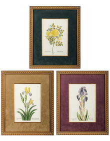
Georg Wolfgang Knorr (German, 1705-1761), Three Antique Hand Colored Botanical Engravings ofHoch LTD.4.5(73)See Sold PriceFeb 25, 2024
Pascal's Collection de fleurs... - Volume with 48 Originally Hand-colored LithographsTrillium Antique Prints & Rare Books4.5(30)See Sold PriceFeb 24, 2024
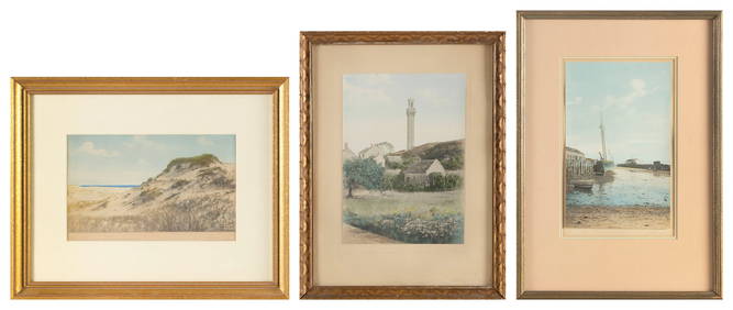
ROBERT WINSLOW (America, Early 20th Century), Three Provincetown views:, Hand-colored photographs,Eldred's4.7(409)See Sold PriceMar 07, 2024


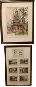
![FRENCH MAPS [3] V. LEVASSEUR, ATLAS ILLUSTRE (1 of 2)](https://p1.liveauctioneers.com/359/44582/19848039_1_x.jpg?height=282&quality=70&version=1377883298)


![[ARCTIC]. BOWEN, Emanuel. A New & Accurate Map of the North... (1 of 1)](https://p1.liveauctioneers.com/928/318880/171360917_1_x.jpg?height=282&quality=70&version=1707501302)