SoldThree Early Maps & Guides for Normandy FranceExcellent lot of three early Normandy items to include a fold out early 20th c. Bicycle Map, an 1880 tour guide with small individual maps and an early 20th c. guide with map in back. The maps are inSee Sold Price
SoldTHREE EARLY TRAVEL GUIDES AND MAPS.Includes Map of the States of Ohio, Indiana, and Illinois with the Settled Parts of Michigan and Wisconsin, Philadelphia: Augustus Mitchell, 1844, fold-out, handcolored, 17 3/4" x 21 1/2" map bound inSee Sold Price
Sold(3) Early Florida Maps, Bloomfield, Colton, 1880sThree early Florida maps including Bloomfield's Illustrated Historical Guide to St. Augustine, along with two copies of G.W. & C.B. Colton's New Sectional Map of the State of Florida. All circa 1880s.See Sold Price
SoldThree early mapsFrance, "Galliae Regni Potentiss: Nova Descriptio Ioanne Ioliveto Auctore," hand colored, text verso, paper reinforcing tape on fold crease and at top verso, scattered browning, original edges,14-3/4See Sold Price
SoldThree Early Maps of the Mouth of the MississippiGroup of Three Hand-Colored Engraved Maps of the Mouth of the Mississippi River from Pierre-Francois Xavier Charlevoix's Histoire et Description Generale de la Nouvelle France by Jacques-Nicolas BelliSee Sold Price
Three early maps of North AmericaAmerique Septentrionale, par Fx (Francois) Delamarche, 1833. Suite du Cours du Fleuve de St. Laurent, Depuis Quebec jusqu'au Generale des Voyages. Echelle de Lieues communes de France.See Sold Price
SoldThree Early German Maps of EuropeThree early European maps, created in Germany, depicting Deutschland (Germany) and Frankreich (France) and Europa (Europe) each measures approx. 16" x 12" ID all in matching framesSee Sold Price
SoldFrance.- Bonne (Rigobert) A group of regional mapsFrance.- Bonne (Rigobert) A group of regional maps including Normandy, Brittany, Champagne, Isle de France, Gascony and Languedoc, 14 engraved maps in early outline hand-colour, on laid paper, each apSee Sold Price
SoldThree Early 19th Century Handwritten School JournaThree Early 19th Century Handwritten School Journals and Young Girl's Journal, the three 1836-39 Frances C. Bosworth, with drawn and colored map, and one 1831 Caroline Sanford, with verse.See Sold Price
SoldFrance.- Normandy.- Ottens (Reiner & Joshua) LeFrance.- Normandy.- Ottens (Reiner & Joshua) Le Gouvernement de Normandie..., regional map with fold-out section in the upper right corner, engraving, an excellent impression with early hand-colouringSee Sold Price
Sold(3) Early Florida Travel Guides, 19th CenturyThree hardback Flordia travel guides including Florida of To-Day (1889), Going to Florida? (1925) and Rambler's Guide to Florida (1873). Some with maps. All in good condition.See Sold Price
Sold(2) EARLY MAPS FRANCE & DENMARK(lot of 2) Framed maps, comprising: (1) "A New Map of the Kingdom of Denmark Comprehending North and South Jutland, Zeeland, Fyen, Laaland and Part of Holstein" by John Cary, 1801, published by John CSee Sold Price
SoldThree early maps of Arabia,all hand colored, one by Guillamo Ruscelli, "Tabula Asiae VI", published Venice, 1561-64, Italian text verso, creases and minor stains, 8-5/8 x 12-1/8"; 1618 by Petras Bertius, "A Description D'ArabieSee Sold Price
SoldTHREE EARLY MAPS OF THE RUSSIAN EMPIRETHREE EARLY MAPS OF THE RUSSIAN EMPIRE. Comprising three maps of the Russian Empire including Laurie and Whittle's 1794 map entitled "Map Of The European And Asiatic Parts Of The Russian Empire," imaSee Sold Price
SoldThree Early Maps of South Carolina/North Carolina1. Mid 18th century map titled "A New Map of Carolina by Robert Morden"; page taken from a book or publication "A Description of Carolina"; map size approximately 5" x 5"; page size 6 3/8"W, 8"H; 2. MSee Sold Price
THREE EARLY MAPS. The two largest are hTHREE EARLY MAPS. The two largest are handcolored. Scandinavia, dated 1719. 21" x 25"; Ulster, sold by William Berry in London. 19 3/4" x 23". And a small engraved map of Yorkshire from a magazine. 8"See Sold Price
SoldEarly Map France Spain and PortugalC. 1850 by S. Augustus Mitchell Jr. in the Clerk's Office of the District Court of the U.S. for the Eastern District of Pa. Framed. 14" x 11"See Sold Price
SoldTHREE MAPS HUNGARY & AMERICAN 1755-1873Three early maps, including: 1755 color map of Hungary, 21" x 18" (w/ margins 30" x 22 1/4"), J. Gibson, edgewear, tears, some separation at middle fold, some light staining / toning; 1873 b/w map ofSee Sold Price
SoldJan Jansson Early Map Views France (2)Early maps: Jan Jansson. Calais and Lyon. (2) Map Views in France. Hand-colored engravings. From Theatrum exhibens celebriores Galliae et Helvetiae. Amsterdam, C. 1650s. 19" x 23".See Sold Price
SoldThree Early American Maps"Tennasee (sic) lately the S.Wn. Territory" from "Cary's American Pocket Atlas", Philadelphia, 1801, 8 x 6-1/2 in. (sight), matted with gilt painted frame, sun exposure at center fold; "Tennessee" MapSee Sold Price
SoldGroup of Three Antique Maps, FranceGroup of three antique maps highlighting the Ain, Manche, and Ardennes regions of France.See Sold Price
SoldThree early Southern maps[A Sketch of the Cherokee Country], London, 1772, "Engraved for Rev. Mants History of the War in America By J. Lodge", red "New York Historical Society" oval imprint, 10-3/4 x 18 in., [reduced at bottSee Sold Price
SoldThree early U.S. mapsThree early U.S. maps: "A Plan of the Country from Frogs Point to Croton River Showing the Positions of the American and British Armies from the 12th of October 1776 Until the Engagement on the WhiteSee Sold Price
Sold[THREE MAPS OF FRANCE][THREE MAPS OF FRANCE] , 18th c., hand-colored engravings, "Burgundia Ducatus", 19 in. x 22 1/2 in., with cartouche showing coat of arms and cherubs; "Guienne et Gaslogne, Basse Navarre et Bearn", bySee Sold Price
Frank Serratoni (CA,MI,1908-1970) watercolor paintingBroward Auction Gallery4.7(300)See Sold PriceMar 10, 2024
Early Pennsylvania Railroad Literature - 1881 New York and Chicago Limited Timetable Brochure andRail & Road Auctions4.6(165)See Sold PriceMar 07, 2024
A 1975 Walt Disney World Magic Kingdom Souvenir Map.Van Eaton Galleries4.6(103)See Sold PriceMar 02, 2024
Vintage French White Porcelain & Bronze Two-Tiered Table LampAkiba Galleries4.7(1.8k)See Sold PriceFeb 29, 2024
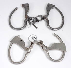
2PC Tower Single Lock Bottom Key HandcuffsBruneau & Co. Auctioneers4.5(491)See Sold PriceMar 18, 2024
2PC Tower Single Lock Side Key Steel HandcuffsBruneau & Co. Auctioneers4.5(491)See Sold PriceMar 18, 2024
Disney Magic Mediterranean Cruise 2007 Map W CoinsRapid Estate Liquidators and Auction Gallery4.5(1.1k)See Sold PriceMar 01, 2024


![[THREE MAPS OF FRANCE] (1 of 8)](https://p1.liveauctioneers.com/268/959/424799_1_x.jpg?height=282&quality=70)