SoldThomson maps of Tartary, and Asia, c.1814-17[Asia]. 2 double-page engraved maps from Thomson's ''A New General Atlas,'' Lon: 1814-1817. Each about 19 1/2 x 23 1/2 in. Very good condition. ++ Tartary. Outline coloring. ++ Asia. Full hand-colorinSee Sold Price
SoldT Cowperthwait: Russia In Asia & Tartary MapRussia in Asia and Tartary, 17 x 13.5 in, 1850, Thomas Cowperthwait Please note that this lot has a confidential reserve. When you leave a bid in advance of the auction, submit your maximum. Jasper52See Sold Price
Thomson: Antique Map of Asia, 1817Map: Asia. Publication Date: 1817 Cartographer: THOMSON, JOHN & CO. Publisher: JOHN THOMSON, JUNR. & CO. 1817 EDINBURGH Size: Double Folio – 17.75 H x 20.00 W Inches No.29 from Thomson's New GeneralSee Sold Price
Independent & Chinese "Tartary". Central Asia Tibet Silk Road. THOMSON 1817 mapTITLE/CONTENT OF MAP: Tartary [or central parts of Asia] A large detailed map showing Central Asia or "Tartary". The Great Wall of China is marked, delineating the northern border of China with ChinesSee Sold Price
Independent & Chinese "Tartary". Central Asia Tibet Silk Road. THOMSON 1830 mapTITLE/CONTENT OF MAP: 'Tartary' A large detailed map showing Central Asia or "Tartary". The Great Wall of China is marked, delineating the northern border of China with Chinese Tartary. The Silk RoadSee Sold Price
Independent & Chinese "Tartary". Central Asia Silk Road Tibet. THOMSON 1817 mapTITLE/CONTENT OF MAP: Tartary [or central parts of Asia] A large detailed map showing Central Asia or "Tartary". The Great Wall of China is marked, delineating the northern border of China with ChinesSee Sold Price
SoldMap of Tartary comprising most of AsiaHeading: (Maps) Author: Thomson, John Title: Tartary Place Published: Edinburgh Publisher: Date Published: 1814 Description: Engraved map, hand-colored in outline. 49.8x59.5See Sold Price
Map of Tartary comprising most of AsiaHeading: Author: Thomson, John Title: Tartary Place Published: Edinburgh Publisher: Date Published: 1814 Description: Engraved map, hand-colored in outline. 49.8x59.5 cm (1See Sold Price
Asia.Map: Asia. Date: 1817 Cartographer: THOMSON, JOHN & CO. Publisher: JOHN THOMSON, JUNR. & CO. Size (inches): 17.75X20 No.29 from Thomson's New General Atlas 1817. J. & G. Menzies, engraver. Australia iSee Sold Price
SoldMitchell Cowperthwait: Map of Russia in Asia & TartaryTitle: Map of Russia in Asia and Tartary By Mitchell, Thomas, and Cowperthwait Date: 1851 Dimensions: 17 x 14 Medium: Hand Colored Lithograph Please note that this lot has a confidential reserve. WhenSee Sold Price
Map of Russia and TartaryAuthor: Cowperthwait Title: Map of Russia and Tartary Medium: Ink on Paper Dimensions: 17"X14" Map of Russia in Asia and Tartary dated 1850. Engraved and published by Thomas Cowpertwaith in PhiladelphSee Sold Price
Sold1850 Map of RussiaAuthor: Cowperthwait Title: 1850 Map of Russia Medium: Ink on Paper Dimensions: 17"X14" Map of Russia in Asia and Tartary dated 1850. Engraved and published Thomas Cowperthwait. Key upper left. InsetSee Sold Price
Ortelius Map of Tartary*** START PRICE IS THE RESERVE *** [Asia] ORTELIUS, Abraham (1527-1598). Tartariae sive magni chami regni typus. Engraved map with hand color in full. Antwerp, 1587 or later (State 3). 21 ¼Â” x 17See Sold Price
SoldCary. A NEW MAP OF CHINESE & INDEPENDENT TARTARY.[Asia] A NEW MAP OF CHINESE & INDEPENDENT TARTARY, FROM THE LATEST AUTHORITIES. Lon: J. Cary, 1806. Shows most of Asia, including Kamchatka, Japan and northern Philippines. Contemp hand coloring. 17 �See Sold Price
1827 Thomson Map of Asia -- AsiaTitle: 1827 Thomson Map of Asia -- Asia Cartographer: J Thomson Year / Place: 1827, London Map Dimension (in.): 20.2 X 23.6 in. This is an excellent, large, double page map of Asia. The Great Wall ofSee Sold Price
SoldSanson geography of Asia 17 mapsHeading: Author: Sanson, Nicolas Title: L'Asie en plusieurs cartes nouvelles et exactes et en divers traittés de géographie et d'histoire... Ses empires, ses monarchies, ses estats, &c., les moeursSee Sold Price
Bellin: Two Maps of Tartary (Central-Northeast Asia)Title/Content of Map: Bellin: Two Maps of Tartary (Central-Northeast Asia) Date Printed: 1749/1760, Paris Cartographer: Jacques Nicolas Bellin Size: 12" x 8 1/2" (each) Bellin's highly detailed maps oSee Sold Price
Bellin: Two Maps of Tartary (Central-Northeast Asia)Bellin's highly detailed maps of Eastern and Western Tartary from Prevost d'Exiles' influential collection of travel narratives, Histoire Generale des Voyages.The upper map (Tartarie Orientale) encompSee Sold Price
Bellin: Two Maps of Tartary (Central-Northeast Asia)Bellin's highly detailed maps of Eastern and Western Tartary from Prevost d'Exiles' influential collection of travel narratives, Histoire Generale des Voyages.The upper map (Tartarie Orientale) encompSee Sold Price
Bellin: Two Maps of Tartary (Central-Northeast Asia)Map Title: 1. Carte de la Tartarie Orientale. 2. Carte de la Tartarie Occidentale Cartographer: Jacques Nicolas Bellin Place/Date: Paris / 1749/1760 Size: 12" x 8 1/2" (each) Condition: b&w; light oveSee Sold Price
Thomson: Antique Map of Tartary, 1817Map: Tartary. Publication Date: 1817 Cartographer: THOMSON, JOHN & CO. Publisher: JOHN THOMSON, JUNR. & CO. 1817 EDINBURGH Size: Double Folio – 19.25 H x 23.25 W Inches No.31 from Thomson's New GeneSee Sold Price
Tallis/Rapkin: Map of Asia, 1849Map: 'Asia. Tartary Siam Persia Cabool Cochinchina East Indies' States marked on the map include Siberia, Cochin China, China, Hindoostan, Cabool (Kabul), Turkey, Arabia, Persia, Beloochistan, Birmah,See Sold Price
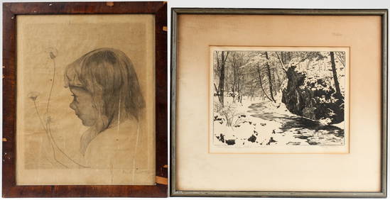
Early 19th Century Manuscript Map of AsiaEarly 19th century hand drawn and colored map of Asia measuring 17.5" x 21.5" (sight) housed in frame measuring 19.5" x 23.5". Reverse of frame exhibits fragment of old label with text "This map was mSee Sold Price
Moll: Antique Map of Tartary and Central Asia, 1732Title/Content of Map: 1732 Moll Map of Tartary and Central Asia -- Great Tartary. With the Tract of the Moscovite Ambassador's Travels from Moscow to Pekin in China… Date Printed: 1732, London CartoSee Sold Price
1818 RARE Geography Made Easy MAPS Jedidiah Morse Boston Indians Atlas AsiaSchilb Antiquarian Rare Books4.8(421)See Sold PriceMar 31, 2024
1849 Mitchell School ATLAS 24 MAPS America Holy Land France Africa Egypt AsiaSchilb Antiquarian Rare Books4.8(421)See Sold PriceMar 31, 2024
[CHICAGO]. Rare Pre-Fire Illinois Map: “Blanchard’s Map of ...Potter & Potter Auctions4.6(539)See Sold PriceMar 07, 2024
Willem Blaeu, Etc. 17th C. Antiquarian Maps, 2Auctions at Showplace4.5(726)See Sold PriceMar 17, 2024
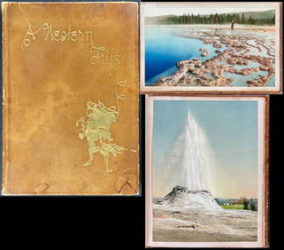
Schmidt's Memoir, A Western Trip - Volume with 12 Photos by William Henry Jackson, 17 by Schmidt andTrillium Antique Prints & Rare Books4.5(30)See Sold PriceFeb 24, 2024
Carey, pub. 1796 - A Chart of the West IndiesTrillium Antique Prints & Rare Books4.5(30)See Sold PriceFeb 24, 2024
Carey, pub. 1796 - Map of GeorgiaTrillium Antique Prints & Rare Books4.5(30)See Sold PriceFeb 24, 2024
Carey, pub. 1796 - Map of The State of South CarolinaTrillium Antique Prints & Rare Books4.5(30)See Sold PriceFeb 24, 2024
Carey, pub. 1796 - Map of KentuckyTrillium Antique Prints & Rare Books4.5(30)See Sold PriceFeb 24, 2024
Carey, pub. 1796 - Map of the Tennassee State formerly part of North Carolina (Tennessee)Trillium Antique Prints & Rare Books4.5(30)See Sold PriceFeb 24, 2024
De Jode, Rare, pub. 1593 - Map of the Middle East, Eastern Asia (Primae Partis Asiae accurataTrillium Antique Prints & Rare Books4.5(30)See Sold PriceFeb 24, 2024
1738 RUSSIA SIBERIA & GREAT TARTARY Description illustrated ANTIQUE in ENGLISHJasper524.5(9.8k)See Sold PriceFeb 27, 2024
JAWS RIDE AT UNIVERSAL STUDIOS FLORIDA - Set of Ride DocumentsPropstore4.2(6)See Sold PriceMar 14, 2024
Pre-colonial Africa. Mountains of Kong/Moon. Caravan routes. THOMSON 1817 mapJasper524.5(9.8k)See Sold PriceFeb 28, 2024
ANTIQUE ILLUSTRATED HANDBOOK OF GEOGRAPHY AND TRAVEL IN ASIA, VOLUME 2, 1896NY Elizabeth 4.3(84)See Sold PriceMar 03, 2024


![[CHICAGO]. Rare Pre-Fire Illinois Map: “Blanchard’s Map of ... (1 of 2)](https://p1.liveauctioneers.com/928/318880/171361260_1_x.jpg?height=282&quality=70&version=1707501302)