ATLAS of ANTIENT GEOGRAPHY by SAMUEL BUTLER 1843John McInnis Auctioneers,LLC4.6(502)See Sold PriceFeb 24, 2024
18TH C. ANTIQUE MAP: FRENCH & INDIAN WAR, FRAMEDThomaston Place Auction Galleries4.4(386)See Sold PriceFeb 24, 2024
Rand McNally Railroad Map Cabinet w/ 21 Railroad MapsRail & Road Auctions4.6(165)See Sold PriceMar 08, 2024
Keith Haring - Ink on New York Map, Best Buddies, Inscribed, Signed, and DatedSapphire Auction Gallery4(67)See Sold PriceMar 02, 2024
LATE 17TH C. FRENCH MAP OF THE NEW WORLD BY ALEXIS-HUBERT JAILLOT (1632-1712)Thomaston Place Auction Galleries4.4(386)See Sold PriceFeb 24, 2024
Central Railroad of New Jersey Map of Sandy Hook Route-ca. 1903JM Hobby Supply and Railroad Artifact Auctions4.4(126)See Sold PriceFeb 24, 2024
Lot of Six Mixed Atlas Box Cars-HO Scale-New in BoxJM Hobby Supply and Railroad Artifact Auctions4.4(126)See Sold PriceFeb 25, 2024
Rand McNally/Santa Fe Railroad Map of Iowa-1912JM Hobby Supply and Railroad Artifact Auctions4.4(126)See Sold PriceFeb 24, 2024
NICOLAES VISSCHER (NETHERLANDS, 1618-1709) MAP OF THE NEW WORLDThomaston Place Auction Galleries4.4(386)See Sold PriceFeb 24, 2024
17TH C. WORLD MAP BY NICOLAES VISSCHER (NETHERLANDS, 1618-1709)Thomaston Place Auction Galleries4.4(386)See Sold PriceFeb 24, 2024
Lot of Six Mixed Atlas Cabooses-HO Scale-New in BoxJM Hobby Supply and Railroad Artifact Auctions4.4(126)See Sold PriceFeb 25, 2024
Thomson: Map of British India South/North, 1814British India Southern Part/British India Northern Part. A paired set of British India maps from Thomson's New General Atlas, both both beautifully detailed and colored. The Northern India map includeSee Sold Price
SoldThomson: Antique Map of British India, 1814Map: British India Southern Part/British India Northern Part Cartographer: Thomson Place & Date: Edinburgh / 1814/1817 Size: 24 1/8" x 22 5/8" Condition: overall age-toning and spotting; repaired spliSee Sold Price
SoldHand-colored map of Hindostan 1814Title: Hindoostan Author: Thomson, John Description: Copper-engraved map, hand-colored. 45.60.5 cm. (17¾x23¾").Well-engraved map of India as the British East India Company held sway. At the right-haSee Sold Price
SoldHand-colored map of Hindostan 1814Title: Hindoostan Author:Thomson, John Description:Copper-engraved map, hand-colored. 45.60.5 cm. (17¾x23¾"). Well-engraved map of India as the British East India Company held sway. At the right-hanSee Sold Price
Thomson: Antique Map of British India, 1817TITLE/CONTENT OF MAP: 'British India, southern part' A large detailed map of southern India showing British territories and Native States. The Malabar, Coromandel and Pirate coasts are marked. Part ofSee Sold Price
Thomson: Antique Map of Southern British India 1817TITLE/CONTENT OF MAP: 'British India, southern part' A large detailed map of southern India showing British territories and Native States. The Malabar, Coromandel and Pirate coasts are marked. Part ofSee Sold Price
Thomson: Antique Map of Northern British India, 1817British India, northern part. Nepaul. Cabul' A detailed map of Northern British India, Nepal, and the environs of Kabul. The supposed course of the "Gaggar" (Ghaggar or Luni) river is marked running tSee Sold Price
Thomson: Antique Map of Southern British India, 1817British India, southern part' A large detailed map of southern India showing British territories and Native States. The Malabar, Coromandel and Pirate coasts are marked. Part of ceylon is shown. DateSee Sold Price
Thomson: Antique Map of Northern British India, 1817TITLE/CONTENT OF MAP: 'British India, northern part. Nepaul. Cabul' A detailed map of Northern British India, Nepal, and the environs of Kabul. The supposed course of the "Gaggar" (Ghaggar or Luni) riSee Sold Price
SoldHand Colored Engraving Thomson Map of India 1816Hand colored steel plate engraving of the map of India, 1816. Thomson mapmakers of England. Certificate of Authenticity from Geographicus, NYC. on back has a date of 1814. Map measures: 16" W x 18" H,See Sold Price
Thomson: Antique Map of Hindoostan & Ceylon, 1817Title/Content of Map: 'Hindoostan. Isle of Ceylon' British India & Ceylon. Sri Lanka Date Printed: 1817 Image Size: Approx 49.5 x 44.0cm, 19.5 x 17.25 inches (Large); Please note that this is a foldinSee Sold Price
SoldThomson: Map of Hindoostan, 1814Map: Hindoostan Cartographer: Thomson Place & Date: Edinburgh / 1814/1817 Size: 24 1/8" x 22 5/8" Condition: light overprinting and minor spotting The magnificent India map Thomson's influential New GSee Sold Price
SoldIndia in 1814Heading: (Maps) Author: Thomson, John Title: Hindoostan Place Published: Edinburgh Publisher: Date Published: 1814 Description: Engraved map, hand-colored. 45x40 cm (17¾x15¾See Sold Price
SoldIndia.- Thomson (John) British India, Southern Part;India.- Thomson (John) British India, Southern Part; British India, Northern Part; Hindoostan, three maps of India from Thomson's New General Atlas, the first two mentioned forming a two-sheet map ofSee Sold Price
Sold1814 Thomson Map of St. Vincent and Barbados -- WestTitle/Content of Map: 1814 Thomson Map of St. Vincent and Barbados -- West India Islands. St. Vincent [on sheet with] Barbadoes Cartographer: J Thomson Year/Place: 1814, Edinburgh Size: 19.7 X 23 in.See Sold Price
1814 Thomson Map of St. Vincent and Barbados -- WestTitle/Content of Map: 1814 Thomson Map of St. Vincent and Barbados -- West India Islands. St. Vincent [on sheet with] Barbadoes Date: 1814, Edinburgh Cartographer: J Thomson Size: 19.7 X 23 in. This iSee Sold Price
1814 Thomson Map of St. Vincent and Barbados -- WestTitle/Content of Map: 1814 Thomson Map of St. Vincent and Barbados -- West India Islands. St. Vincent [on sheet with] Barbadoes Cartographer: J Thomson Year/Place: 1814, Edinburgh Size: 19.7 X 23 in.See Sold Price
Thomson: Map of Canada & Nova Scotia, 1814Map: Canada and Nova Scotia Cartographer: Thomson Place & Date: Edinburgh / 1814/1817 Size: 23 3/4" x 19 1/8" Condition: light browning and minor staining in margins The superbly detailed British NortSee Sold Price
SoldThomson: St. Vincent and BarbadosReserve Reduced! Title of Map: West India Islands. St. Vincent. Barbadoes. Cartographer: John Thomson Place / Date: Edinburgh / 1814/1817 Size: 23 3/4" x 20" Condition: overall age toning; browning anSee Sold Price
India in 1814Heading: Author: Thomson, John Title: Hindoostan Place Published: Edinburgh Publisher: Date Published: 1814 Description: Engraved map, hand-colored. 45x40 cm (17¾x15¾").See Sold Price
Thomson: Antique Map of St. Vincent & Barbados, 1814West India Islands. St. Vincent. Barbadoes. Two islands on one sheet, from Thomson's New General Atlas, both with dramatic topography and numerous place names. Cartographer: John Thomson Place & Date:See Sold Price
SoldThomson (John) West India Islands-. Thomson (John) West India Islands, engraved map of Guadaloupe, Antigua, Mariegalante, etc., with original outline hand-colouring, 500 x 595mm., short tears to vertical fold, 1814 ? ArrowsmiSee Sold Price
Sold-. Thomson (John) West India IslandsThomson (John) West India Islands,engraved map of Guadaloupe, Antigua, Mariegalante, etc., with original outline hand-colouring, 500 x 595mm., short tears to vertical fold, 1814 § Arrowsmith (See Sold Price
SoldThomson (John) West India IslandsThomson (John) West India Islands,engraved map of Guadaloupe, Antigua, Mariegalante, etc., with original outline hand-colouring, 500 x 595mm., short tears to vertical fold, 1814 § Arrowsmith (See Sold Price
Jerusalem Map for British Soldiers in Palestine - WW2Levy Auction House4.3(11)See Sold PriceFeb 27, 2024
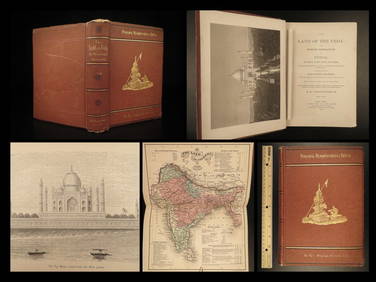
1872 INDIA Land of the Veda Travel Exploration Voyages Hindu Sepoy RebellionSchilb Antiquarian Rare Books4.8(421)See Sold PriceMar 31, 2024
Duval - Pair: Map of India & Map of MaldivesTrillium Antique Prints & Rare Books4.5(30)See Sold PriceFeb 24, 2024
D'Oyly (Calcutta, India) - Government House from St. Andrew's LibraryTrillium Antique Prints & Rare Books4.5(30)See Sold PriceFeb 24, 2024
D'Oyly (Calcutta, India) - Procession of the CurruckpoojaTrillium Antique Prints & Rare Books4.5(30)See Sold PriceFeb 24, 2024
GOVIND SOLEGAONKAR (Sehore, Madhya Pradesh, British India, 1912-1986). "Abstract composition."Setdart Auction House4.1(22)See Sold PriceMar 05, 2024
INDIA WITHIN THE GANGES SUSAN GOLE ILLUSTRATED MAPS EARLY CARTOGRAPHYJasper524.5(9.8k)See Sold PriceFeb 27, 2024
Pre-colonial Africa. Mountains of Kong/Moon. Caravan routes. THOMSON 1817 mapJasper524.5(9.8k)See Sold PriceFeb 28, 2024
Stanford, Edward 1901 Large Map. Geological Map of the British IslesAlbion Auctions4.6(336)See Sold PriceMar 01, 2024
Paterson & Mogg 1822 Pair of British Road Maps. Deal, Hythe, Shoreham, ChichesterAlbion Auctions4.6(336)See Sold PriceMar 01, 2024
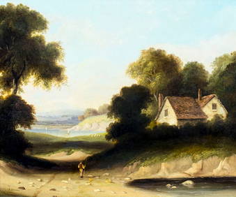
John Joseph Cotman (UK,1814-1878) oil painting antiqueBroward Auction Gallery4.8(277)See Sold PriceMay 19, 2024
James Sowerby (1757 - 1822) - Set of 8 Botanical Prints - Heath Cudweed - Saxifraga Nivalis -Proverde Auctions4.3(3)See Sold PriceFeb 28, 2024
James Sowerby (1757 - 1822) - Set of 8 Botanical Prints - Birthwort, Aristolochia clematitis -Proverde Auctions4.3(3)See Sold PriceFeb 28, 2024
James Sowerby (1757 - 1822) - Set of 10 Botanical Prints -Proverde Auctions4.3(3)See Sold PriceFeb 28, 2024
James Sowerby (1757 - 1822) - Set of 10 Botanical Prints - Common Sea-Buckthorn - Orobanche RapumProverde Auctions4.3(3)See Sold PriceFeb 28, 2024
James Sowerby (1757 - 1822) - Set of 10 Botanical Prints - Orobanche Common Lesser - CentrolepisProverde Auctions4.3(3)See Sold PriceFeb 28, 2024
James Sowerby (1757 - 1822) - Set of 10 Botanical Prints - Potentilla anserina - Poa aquatica -Proverde Auctions4.3(3)See Sold PriceFeb 28, 2024