ATLAS of ANTIENT GEOGRAPHY by SAMUEL BUTLER 1843John McInnis Auctioneers,LLC4.6(502)See Sold PriceFeb 24, 2024
18TH C. ANTIQUE MAP: FRENCH & INDIAN WAR, FRAMEDThomaston Place Auction Galleries4.4(386)See Sold PriceFeb 24, 2024
Rand McNally Railroad Map Cabinet w/ 21 Railroad MapsRail & Road Auctions4.6(165)See Sold PriceMar 08, 2024
Keith Haring - Ink on New York Map, Best Buddies, Inscribed, Signed, and DatedSapphire Auction Gallery4(67)See Sold PriceMar 02, 2024
LATE 17TH C. FRENCH MAP OF THE NEW WORLD BY ALEXIS-HUBERT JAILLOT (1632-1712)Thomaston Place Auction Galleries4.4(386)See Sold PriceFeb 24, 2024
Central Railroad of New Jersey Map of Sandy Hook Route-ca. 1903JM Hobby Supply and Railroad Artifact Auctions4.4(126)See Sold PriceFeb 24, 2024
Lot of Six Mixed Atlas Box Cars-HO Scale-New in BoxJM Hobby Supply and Railroad Artifact Auctions4.4(126)See Sold PriceFeb 25, 2024
Rand McNally/Santa Fe Railroad Map of Iowa-1912JM Hobby Supply and Railroad Artifact Auctions4.4(126)See Sold PriceFeb 24, 2024
NICOLAES VISSCHER (NETHERLANDS, 1618-1709) MAP OF THE NEW WORLDThomaston Place Auction Galleries4.4(386)See Sold PriceFeb 24, 2024
17TH C. WORLD MAP BY NICOLAES VISSCHER (NETHERLANDS, 1618-1709)Thomaston Place Auction Galleries4.4(386)See Sold PriceFeb 24, 2024
Lot of Six Mixed Atlas Cabooses-HO Scale-New in BoxJM Hobby Supply and Railroad Artifact Auctions4.4(126)See Sold PriceFeb 25, 2024
SoldThomson: Antique Map Northeastern United States, 1817Northern Provinces of the United States The beautifully detailed and colored northern United States map from Thomson's New General Atlas, with a lovely inset view of "the Great Falls of Niagara.'" CarSee Sold Price
Thomson: Antique Map of Southern United States, 1817Southern provinces of the United States' The map shows the United States including the first 17 states to acceed, including Tennessee, which had joined in 1796. Ohio, Louisiana and Indiana, which hadSee Sold Price
SoldThomson: Antique Map of Southeastern United States 1817Southern Provinces of the United States A beautiful exemplar of the southern United States map from Thomson's New General Atlas, with a lovely inset view of "Characteristic Scenery of the Hudson RiverSee Sold Price
Thomson: Antique Map of the United States, 1817United States of America' The map shows the United States including the first 17 states to acceed, including Tennessee, which had joined in 1796. Ohio, Louisiana and Indiana, which had all joined theSee Sold Price
Thomson: Antique Map of Southwest United States, 1817TITLE/CONTENT OF MAP: 'Southern provinces of the United States' The map shows the United States including the first 17 states to acceed, including Tennessee, which had joined in 1796. Ohio, LouisianaSee Sold Price
Thomson: Antique Map of Northern United States, 1817Title/Content of Map: 'Northern provinces of the United States' The map shows the "District of Maine", prior to its accession to the Union as the state of Maine in 1820. Some Native American Indian viSee Sold Price
Thomson: Antique Map of Northern United States, 1817TITLE/CONTENT OF MAP: 'Northern provinces of the United States' The map shows the "District of Maine", prior to its accession to the Union as the state of Maine in 1820. Some Native American Indian viSee Sold Price
SoldAntique Map United States Thomson's 1817Antique Map United States Thomson's 1817, authentic antique map, inscribed, "drawn & engraved for Thomson's new general atlas 1817", along with "Northern Provinces of the United States", hand coloredSee Sold Price
SoldThomson: Antique Map of U.S. / St. Lawrence River, 1817Map: The Course of the River St. Laurence/United States of America Cartographer: Thomson Place & Date: Edinburgh / 1817 Size: 24 1/4" x 16 1/8" Condition: overprinting and light age-toning throughout;See Sold Price
Thomson: Antique Map of US Northern Provinces, 1817Title/Content of Map: 'Northern provinces of the United States' The map shows the "District of Maine", prior to its accession to the Union as the state of Maine in 1820. Some Native American Indian viSee Sold Price
SoldMap of the Southern Province of U.S. 1817An Antique Hand-Colored Map of the Southern Provinces of the United States, 1817, from Thomson's New General Atlas, copper-engraved map, sheet 21 1/2 in. x 28 3/4 inSee Sold Price
Sold2 United States Maps, including 1817.2 United States Maps, including 1817. 1st item: Northern Provinces of the United States map by John Thomson from "Thomson's New General Atlas", engraved by Nathaniel Rodgers Hewitt, 1817. Colored mapSee Sold Price
SoldThomson/Hewitt Map, 1817 Southern Provinces of US"Map of the Southern Provinces of the United States", drawn and engraved by N. R. Hewitt, published by John Thomson, Edinburgh, John Cumming, Dublin, and Baldwin, Cradock, and Joy, London, 1817. FromSee Sold Price
Thomson: Antique Map of Venetian States, 1817TITLE/CONTENT OF MAP: 'Venetian States' This large map shows the main contiguous part of the Republic of Venice, although as an entity it had ceased to exist in 1797 DATE PRINTED: 1817 IMAGE SIZE: AppSee Sold Price
Thomson: Antique Map of Venetian States, Italy, 1817TITLE/CONTENT OF MAP: 'Venetian States' This large map shows the main contiguous part of the Republic of Venice, although as an entity it had ceased to exist in 1797 DATE PRINTED: 1817 IMAGE SIZE: AppSee Sold Price
Bonne: Antique Map of Northeastern USA, 1780Title/Content of Map: 'Carte de la Partie Nord des Etats Unis de l'Amérique Septentrionale' A map of the northeastern United States: Mid-Atlantic States and New England Date Printed: 1780 Image Size:See Sold Price
Bonne: Antique Map of Northeastern USA, 1780Title/Content of Map: 'Carte de la Partie Nord des Etats Unis de l'Amérique Septentrionale' A map of the northeastern United States: Mid-Atlantic States and New England Date Printed: 1780 Image Size:See Sold Price
Sold1780 - Antique map of Canadian Maritime Provinces. 1780Title/Content of Map: 1780 - Antique map of Canadian Maritime Provinces. 1780 Cartographer: Rigobert Bonne Date Printed: 1780 Description: Colonial Northeastern United States & Canada. Rigobert Bonne,See Sold Price
Thomson: Antique Map of Southern provinces of USTITLE/CONTENT OF MAP: 'Southern provinces of the United States' The map shows the United States including the first 17 states to acceed, including Tennessee, which had joined in 1796. Ohio, LouisianaSee Sold Price
Bonne: Antique Map of Northeast United States, 1780TITLE/CONTENT OF MAP: 'Carte de la Partie Nord des Etats Unis de l'Amérique Septentrionale' A map of the northeastern United States: Mid-Atlantic States and New England DATE PRINTED: 1780 IMAGE SIZE:See Sold Price
Thomson: Antique Map of Northern provinces of the USTITLE/CONTENT OF MAP: 'Northern provinces of the United States' The map shows the "District of Maine", prior to its accession to the Union as the state of Maine in 1820. Some Native American Indian viSee Sold Price
SoldTWO FRAMED MAPSAn antique atlas map of Nantucket, together with a reprinted map of of the North Eastern United States. Larger, 26 by 35 inches Categories: Tommy HilfigerSee Sold Price
SoldThomson: Antique Map of The Venetian States, 1814Title/Content of Map: The Venetian States Cartographer: Thomson Place & Date: Edinburgh / 1814/1817 Size: 19 1/4" x 23 1/4" Condition: light overprinting; minor spotting; some browning along the centeSee Sold Price
SoldJOHN THOMSON (Scottish 1777-circa 1840) A HAND COLOREDJOHN THOMSON (Scottish 1777-circa 1840) A HAND COLORED MAP, "Southern Provinces of the United States," 1817, with an engraved view at the upper left quadrant of "Characteristic Scenery of the Hudson RSee Sold Price
Arrowsmith & Lewis - Map of the United StatesTrillium Antique Prints & Rare Books4.5(30)See Sold PriceFeb 24, 2024
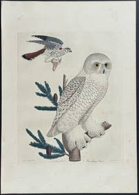
Wilson - Snow Owl (Snowy Owl) & Sparrow Hawk. 32Trillium Antique Prints & Rare Books4.5(30)See Sold PriceFeb 24, 2024
Wilson - Ivory-billed Woodpecker, Red-headed & Pileated Woodpeckers. 29Trillium Antique Prints & Rare Books4.5(30)See Sold PriceFeb 24, 2024
Wilson - Carolina Parrot & Flycatchers. 26Trillium Antique Prints & Rare Books4.5(30)See Sold PriceFeb 24, 2024
Cooke, George 1801 Antique Map. United States of AmericaAlbion Auctions4.6(336)See Sold PriceMar 01, 2024
Blackie (Pub) 1882 Folio Map. West USA - Pacific StatesAlbion Auctions4.6(336)See Sold PriceMar 01, 2024
Blackie (Pub) 1882 Folio Map. United States of North AmericaAlbion Auctions4.6(336)See Sold PriceMar 01, 2024