ATLAS of ANTIENT GEOGRAPHY by SAMUEL BUTLER 1843John McInnis Auctioneers,LLC4.6(502)See Sold PriceFeb 24, 2024
18TH C. ANTIQUE MAP: FRENCH & INDIAN WAR, FRAMEDThomaston Place Auction Galleries4.4(386)See Sold PriceFeb 24, 2024
Rand McNally Railroad Map Cabinet w/ 21 Railroad MapsRail & Road Auctions4.6(165)See Sold PriceMar 08, 2024
Keith Haring - Ink on New York Map, Best Buddies, Inscribed, Signed, and DatedSapphire Auction Gallery4(67)See Sold PriceMar 02, 2024
LATE 17TH C. FRENCH MAP OF THE NEW WORLD BY ALEXIS-HUBERT JAILLOT (1632-1712)Thomaston Place Auction Galleries4.4(386)See Sold PriceFeb 24, 2024
Central Railroad of New Jersey Map of Sandy Hook Route-ca. 1903JM Hobby Supply and Railroad Artifact Auctions4.4(126)See Sold PriceFeb 24, 2024
Lot of Six Mixed Atlas Box Cars-HO Scale-New in BoxJM Hobby Supply and Railroad Artifact Auctions4.4(126)See Sold PriceFeb 25, 2024
Rand McNally/Santa Fe Railroad Map of Iowa-1912JM Hobby Supply and Railroad Artifact Auctions4.4(126)See Sold PriceFeb 24, 2024
NICOLAES VISSCHER (NETHERLANDS, 1618-1709) MAP OF THE NEW WORLDThomaston Place Auction Galleries4.4(386)See Sold PriceFeb 24, 2024
17TH C. WORLD MAP BY NICOLAES VISSCHER (NETHERLANDS, 1618-1709)Thomaston Place Auction Galleries4.4(386)See Sold PriceFeb 24, 2024
Lot of Six Mixed Atlas Cabooses-HO Scale-New in BoxJM Hobby Supply and Railroad Artifact Auctions4.4(126)See Sold PriceFeb 25, 2024
SoldTHOMAS JEFFERYS, CARIBBEAN, CENTRAL AMERICAN MAPThomas Jefferys (British, died 1771). "An Index Map to the Following Sixteen Sheets Being a Compleat Chart of the West Indies" -1775, engraving with hand coloring for Robert Sayer, map and print selleSee Sold Price
Jefferys / Sayer: Antique Map Nicaragua/Costa Rica 1775Title/Content of Map: Part of the Provinces of Costa Rica and Nicaragua with the Lagunas Cartographer: Thomas Jefferys / Robert Sayer Place & Date: London / 1775 Size: 24 3/4" x 19 1/4" Condition: wasSee Sold Price
SoldJefferys / Sayer: Antique Map of Bay of Honduras, 1775Map: The Bay of Honduras Cartographer: Thomas Jefferys/Robert Sayer Place & Date: London / 1775 Size: 24 3/4" x 19 1/4" Condition: outline color; light overall age toning; several repaired marginal teSee Sold Price
SoldMoll: Antique Map of West Indies Central America, 1746Title/Content of Map: Southern United States, West Indes Mexico Central America Date Printed: 1746 Cartographer: Thomas Salmon & Herman Moll Material/Medium: Paper Size: 14 1/2" 9 1/2" Copperplate engSee Sold Price
SoldMITCHELL'S NEW NATIONAL MAP OF THE UNITED STATES, 1858Rolled map on old dowels, includes the continental United States, Caribbean and Central American countries, and the Sandwich Islands (Hawaii). Dated 1858, with population table at bottom showing resulSee Sold Price
West India Islands & Central American States. Caribbean. STANFORD 1904 old mapCAPTION PRINTED BELOW PICTURE: 'The West India Islands and Central American States' DATE PRINTED: 1904 IMAGE SIZE: Approx 52.5 x 70.5cm, 20.5 x 27.75 inches (Large); Please note that this is a foldingSee Sold Price
Thomas Jefferys: The American Atlas(British, 1719-1771)Twenty-three maps comprised of forty-nine copper plates, on thirty sheets, from The American Atlas; or, a Geographical Description of the Whole Continent of America; Wherein are DeSee Sold Price
SoldCentral America Caribbean Gulf of Mexico chart PortsTITLE/CONTENT OF MAP: 'Central American and West Indian Ports; Inset The Pacific Coast from San Diego to Vancouver; San Francisco; Aleutian; The Pacific Coast from Seattle to Dutch Harbor; Bermudas; KSee Sold Price
Holland Map of St. JohnHolland, Samuel (1728-1801). A Map of the Island of St. John... Engraved map with original hand color in full. London, 1775. Published by Thomas Jefferys in the American Atlas. 21 3/4" x 30" sheet, 26See Sold Price
Philip & Son: Map of Central America Caribbean, 1914TITLE/CONTENT OF MAP: 'Central American and West Indian Ports; Inset The Pacific Coast from San Diego to Vancouver; San Francisco; Aleutian; The Pacific Coast from Seattle to Dutch Harbor; Bermudas; KSee Sold Price
Central America Caribbean Gulf of Mexico chart PortsTITLE/CONTENT OF MAP: 'Central American and West Indian Ports; Inset The Pacific Coast from San Diego to Vancouver; San Francisco; Aleutian; The Pacific Coast from Seattle to Dutch Harbor; Bermudas; KSee Sold Price
Central America Caribbean Gulf of Mexico chart Ports lighthouses LARGE 1918 mapTITLE/CONTENT OF MAP: 'Central American and West Indian Ports; Inset The Pacific Coast from San Diego to Vancouver; San Francisco; Aleutian; The Pacific Coast from Seattle to Dutch Harbor; Bermudas; KSee Sold Price
Central America Caribbean Gulf of Mexico chart Ports lighthouses LARGE 1959 mapTITLE/CONTENT OF MAP: 'Central American and West Indian Ports inset The Lesser Antilles; The Windward Passage; Bermudas; Kingston; Havana; Salina Cruz; Coatzacoalcos; Willemstad, Curacao' DATE PRINTEDSee Sold Price
Central America Caribbean Gulf of Mexico chart Ports lighthouses LARGE 1918 mapTITLE/CONTENT OF MAP: 'Central American and West Indian Ports; Inset The Pacific Coast from San Diego to Vancouver; San Francisco; Aleutian; The Pacific Coast from Seattle to Dutch Harbor; Bermudas; KSee Sold Price
Central America Caribbean Gulf of Mexico chart Ports lighthouses LARGE 1927 mapTITLE/CONTENT OF MAP: Central American and West Indian Ports [inset The Lesser Antilles; The Windward Passage; Bermudas; Kingston; Havana; Salina Cruz; Puerto Mexico; Mouths of the Mississippi] DATE PSee Sold Price
Central America Caribbean Gulf of Mexico chart PortsTITLE/CONTENT OF MAP: 'Central American and West Indian Ports; Inset The Pacific Coast from San Diego to Vancouver; San Francisco; Aleutian; The Pacific Coast from Seattle to Dutch Harbor; Bermudas; KSee Sold Price
Central American Isthmuses and Inland Seas. Caribbean 1885 old antique mapTITLE/CONTENT OF MAP: 'Central American Isthmuses and Inland Seas' DATE PRINTED: 1885 IMAGE SIZE: Approx 10.5 x 11.5cm, 4 x 4.5 inches (Small) TYPE: Antique wood-engraved map; Scale 1:40,000,000 CONDISee Sold Price
Central America Caribbean Gulf of Mexico chart Ports lighthouses LARGE 1952 mapTITLE/CONTENT OF MAP: 'Central American and West Indian Ports inset The Lesser Antilles; The Windward Passage; Bermudas; Kingston; Havana; Salina Cruz; Coatzacoalcos; Willemstad, Curacao' DATE PRINTEDSee Sold Price
Central American Isthmuses and Inland Seas. Caribbean 1885 old antique mapTITLE/CONTENT OF MAP: 'Central American Isthmuses and Inland Seas' DATE PRINTED: 1885 IMAGE SIZE: Approx 10.5 x 11.5cm, 4 x 4.5 inches (Small) TYPE: Antique wood-engraved map; Scale 1:40,000,000 CONDISee Sold Price
Central America Caribbean Gulf of Mexico chart Ports lighthouses LARGE 1959 mapTITLE/CONTENT OF MAP: 'Central American and West Indian Ports inset The Lesser Antilles; The Windward Passage; Bermudas; Kingston; Havana; Salina Cruz; Coatzacoalcos; Willemstad, Curacao' DATE PRINTEDSee Sold Price
Central America Caribbean Gulf of Mexico chart Ports lighthouses LARGE 1952 mapTITLE/CONTENT OF MAP: 'Central American and West Indian Ports inset The Lesser Antilles; The Windward Passage; Bermudas; Kingston; Havana; Salina Cruz; Coatzacoalcos; Willemstad, Curacao' DATE PRINTEDSee Sold Price
Central America Caribbean Gulf of Mexico chart Ports lighthouses LARGE 1927 mapTITLE/CONTENT OF MAP: Central American and West Indian Ports [inset The Lesser Antilles; The Windward Passage; Bermudas; Kingston; Havana; Salina Cruz; Puerto Mexico; Mouths of the Mississippi] DATE PSee Sold Price
SoldJo Mora (1876-1947, Uruguay, CA) pictorial map.This one in particular is from 1933, made for Grace Line. The map focuses on Central America, depicts whimsical cartoons of the events of the colonial era, south and central American, the Caribbean (iSee Sold Price
SoldWonderful Engraved Maps from Jefferys' American AtlasA Map of the most Inhabited Part of Virginia containing the whole Province of Maryland...Drawn by Joshua Fry & Peter Jefferson in 1775. Thomas Jefferys (c. 1719 – 1771). Engraved map with original hSee Sold Price
American Express/New York Central Railroad Map of the United States-1934JM Hobby Supply and Railroad Artifact Auctions4.4(126)See Sold PriceFeb 24, 2024
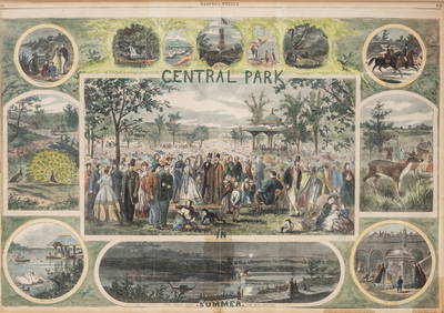
Thomas Nast. New York City engraving "Central Park in Summer" Antique hand colored engraving 1864Collective Hudson4.5(54)See Sold PriceMar 01, 2024
[UPRISING OF ENSLAVED PEOPLE]. American Eagle. No. 1. Salem, MA: Thomas C. Cushing, 5 January 1790.Freeman's | Hindman4.4(1.6k)See Sold PriceFeb 27, 2024
Arrowsmith & Lewis - Map of North AmericaTrillium Antique Prints & Rare Books4.5(30)See Sold PriceFeb 24, 2024
Arrowsmith & Lewis - Map of LouisianaTrillium Antique Prints & Rare Books4.5(30)See Sold PriceFeb 24, 2024
Arrowsmith & Lewis - Map of the United StatesTrillium Antique Prints & Rare Books4.5(30)See Sold PriceFeb 24, 2024
Mckenney & Hall - Two Octavo Volumes of Text with Rare Plate of Billy BowlegsTrillium Antique Prints & Rare Books4.5(30)See Sold PriceFeb 24, 2024
McKenney & Hall, Folio, Rare - 5 Native American LithographsTrillium Antique Prints & Rare Books4.5(30)See Sold PriceFeb 24, 2024
McKenney & Hall, Folio, Rare - Chono-Ca-Pe, An Ottoe ChiefTrillium Antique Prints & Rare Books4.5(30)See Sold PriceFeb 24, 2024
McKenney & Hall, Folio, Rare - Se-Quo-YahTrillium Antique Prints & Rare Books4.5(30)See Sold PriceFeb 24, 2024
McKenney & Hall, Folio, Rare - Po-Ca-Hon-TasTrillium Antique Prints & Rare Books4.5(30)See Sold PriceFeb 24, 2024
McKenney & Hall, Folio, Rare - Hunting the BuffaloeTrillium Antique Prints & Rare Books4.5(30)See Sold PriceFeb 24, 2024
Map of Mexico, Central America, New Grenada, Venzuela and the West IndiesJasper524.5(9.8k)See Sold PriceFeb 27, 2024


![[UPRISING OF ENSLAVED PEOPLE]. American Eagle. No. 1. Salem, MA: Thomas C. Cushing, 5 January 1790. (1 of 3)](https://p1.liveauctioneers.com/197/319238/171468013_1_x.jpg?height=282&quality=70&version=1707520367)


